Notes and Queries


Query 2311


A photograph of an unknown location, possibly taken around 1965 or 1966. The location may, possibly, be near Thornton Junction.

[Added 11 July 2023.]

Answers

Looks like a drift mine or opencast site though the large bing suggest a long mining history in the area. First thought is Kelty Disposal Point, operated by the Opencast Executive, which branched off the West of Fife Mineral Railway.
I don't remember these hopper wagons being used in Fife and would suggest north-east England.
These hopper wagons were used in Fife & Clackmannan (see e.g. images 13684 and 23558). The bing looks like one of the Lumphinnans pits - not No.1 which closed in 1957 but perhaps No.XI pit beside the Lumphinnans Central Jct to Kelty South Jct line. That pit did not close until late 1966. Note the bing is burning and that there appears to be a pylon of an aerial ropeway just to the left of the column of steam coming from the safety valve. Tramways up the bing slope were more common in Fife although Comrie was an exception which had an aerial ropeway for depositing spoil.
Following Mark's noting of Comrie Colliery's unique use of a tip aerial ropeway, have spent some time carefully checking 1950/60s pictures and mapping. Comrie seems very probably the location of the pictured WD 2-8-0 with its tip behind. That has also been also been noted as burning elsewhere. Looks like it is in this location.
Although I'd like to think Michael is right about Comrie, I'm not 100% convinced. First, given Comrie was on an NCB branch, it was normally the NCB locos which took coal to the exchange sidings at Oakley and empties back up. I'm not aware of BR locos using the branch but there might have been exceptions. Second, the hopper loader in the photo also doesn't fit with Comrie - Bill's most recent image 86579 shows the loading arrangements for wagons. Third, the aerial ropeway also ran from beside the washers up on to the bing. This is very clear in the photo of Comrie on the Scottish Mining website which appears to be taken from one of the aerial ropeway pylons looking down towards the pit in its earlier days. The relative alignment of the aerial ropeway and the sidings in that photo is hard to reconcile with the alignment of the sidings and the ropeway in the photo of the WD. Fourth, I think those hopper wagons were solely used to supply Kincardine Power Station and they only worked from a small number of pits and mines which supplied coal from the Upper Hirst seam including Manor Powis, Dollar, and Polmaise 3&4 (and it's clearly not one of those locations). I don't think the Upper Hirst seam was actually mined at Comrie.
Mark Poustie

Given your extensive local operational knowledge of Comrie I have to concede some reservations, despite having earlier found much very persuasive pictorial and diagramatic evidence. Presumably we now need to find a second Fife pit using aerial ropeway for bing disposals. Seems there was not just the one historically as originally suggested. Very struck by the inconsistent coal loading arrangements shown in the two photographs.
My above suggestion of another Fife pit with a ropeway may be purely misleading. Mea culpa. Was merely following the posting's rather leading header - stating "possibly ... near Thornton ...". Given it's not Comrie, with its unique to Fife ropeway, it would seem to leave a location outside the 'kingdom' probable.
There is an online gazetteer of UK aerial ropeways at www.ropeways.co.uk. It does suggest that in addition to Comrie, there were some other pits in Scotland which had ropeways including 2 in Ayrshire and also notes Rothes Colliery but the photo of WD is clearly not at Rothes. However, it does indicate the Lindsay Colliery at Kelty had an aerial ropeway and I've found a photo of that. Lindsay was closed in 1965 and abandoned in 1968 so the dates potentially fit. So Bill's initial suggestion may be close to the mark that the WD is on the remains of West of Fife Mineral Railway near Lindsay. However, again the relative alignment of the ropeway at Lindsay and the sidings don't quite seem to fit this photo of the WD. It did also occur to me that with the blurring of this photo in the foreground it might actually be a grab shot from a passing train which would rule out Lindsay. So Kenny's suggestion of N E England may be correct - and hopefully if it's not Lindsay, the gazetteer may help someone else identify the location.

I think this is probably Manor Powis, which had exactly this type of pylon on the aerial ropeway to the bing (and on the same orientation). Wagons of this type were used here. If correct, the view looks east.
Having looked at the photos on Canmore I agree with your suggestion, Ewan. The photos I have previously seen of Manor Powis were of the 1954 drift mine developed right beside the Forth and the narrow gauge line which brought the coal from there to the preparation plant at the older pit. This view is from the north side of the bing looking eastwards, from the Alloa-Stirling line and as I suggested earlier might be a grab shot from a passing train. Agree that pylons are the same in the Canmore photo and the bing is similarly shaped. These wagons were indeed used on Manor Powis - Kincardine Power Station trains hauling coal mined from the Upper Hirst seam reached at Manor Powis through the 1954 drift mine which finally closed in 1972. So I was clearly wrong in my earlier assessment that this was not Manor Powis.
This sounds good to me. The only place I can clearly remember these wagons locally was at Manor Powis, seen from the train from Dunfermline Upper to Stirling.
This query seems positively resolved now as Manor Powis, given both comments following Ewan's suggestion and subsequent historical checking being fully supportive.


Just to confirm you are a person and not an automated computer system, please type the name of the station.

We need your permission to display your comment. Note that your IP address is stored until the message is approved.

Please note that your comment will not appear immediately.


Query 2306


Where is this and what was purpose of this arrangement of track at the end of this platform? Note the long row of Motorail wagons on the track adjacent to the platform edge.

[Added 10 February 2021.]
Now resolved - see image 75754.

Answers

This is Inverness. Not sure of the purpose of the track arrangement at end of platform, but could be for a shunting loco to wait to remove empty stock from the adjacent platform?
I think this is Inverness, looking back towards the main southbound departure platforms. The short siding is a former end-loading dock, useful for loading a single Carriage Truck, but loading a rake of MotorRail carflats there would completely block the station throat. If memory serves, the far end of the siding where the carflats are stabled was provided with a loading ramp accessed from a narrow lane near the main station building - better than making cars drive all the way along the main departure platforms !
INVERNESS
Inverness station and this was used for the loading of cars onto the motorail wagons
Stirling and the Motorail loading ramp for cars?
Inverness? If so the siding at the platform end was used for unloading car carriers in an early form of motorail.
Platforms 1&2 at Inverness were extended in timber and a loading dock for cars added in 1905. (See photograph on page 58 of The Highland Main Line by Neil T Sinclair.)


Just to confirm you are a person and not an automated computer system, please type the name of the station.

We need your permission to display your comment. Note that your IP address is stored until the message is approved.

Please note that your comment will not appear immediately.


Query 2303


A DMU for Barrow in 1972, but where?

[Added 12 August 2020.]
Now resolved - see image 73977.

Answers

Kents Bank station.
Wrong direction for Kents Bank but the only suggestion I can make is the now closed Sandside between Milnthorpe and Arnside.
Ravenglass, looking north west.
Agree with KL...Ravenglass.
Not Sandside - closed in 1942!
Definitely Ravenglass. The gate leads to the ramped footpath down to the Ratty access road. The train is on the bridge over the village access road which was replaced by a new one a couple of years ago (the bridge not the road). The shelter from which the photo was taken is now part of the R&ER museum.


Just to confirm you are a person and not an automated computer system, please type the name of the station.

We need your permission to display your comment. Note that your IP address is stored until the message is approved.

Please note that your comment will not appear immediately.


Query 2301


A summer Saturday express restarts, but from where?

[Added 10 July 2020.]
Now resolved - see image 73602.

Answers

Forfar? I am thinking that this is at Forfar North Jct with the Black 5 taking the mainline towards Guthrie and the north with the photographer standing on the line to Monifieth?
Forfar North Junction.
Northbound at Forfar North Junction.


Just to confirm you are a person and not an automated computer system, please type the name of the station.

We need your permission to display your comment. Note that your IP address is stored until the message is approved.

Please note that your comment will not appear immediately.


Query 2300


A boy on a buffer stop watches a Black 5 pass a signal box and cottage. But where?
Now resolved - see image 73430.

Answers

Friarton, south of Perth, looking north. See photo 67307.
The old crossing at Friarton south of Perth station. Probably taken in the late 1950s.


Just to confirm you are a person and not an automated computer system, please type the name of the station.

We need your permission to display your comment. Note that your IP address is stored until the message is approved.

Please note that your comment will not appear immediately.


Query 2298


Waiting for a train... where?
Now resolved - see image 73380.

Answers

Bellingham station on the Catford Loop line in south London, looking south.


Just to confirm you are a person and not an automated computer system, please type the name of the station.

We need your permission to display your comment. Note that your IP address is stored until the message is approved.

Please note that your comment will not appear immediately.


Query 2297


View from a train... where?
Now resolved - see image 73359.

Answers

I'd say this was Reading West.
Looks like Reading West prior to electrification
Reading West station.


Just to confirm you are a person and not an automated computer system, please type the name of the station.

We need your permission to display your comment. Note that your IP address is stored until the message is approved.

Please note that your comment will not appear immediately.


Query 2296


Junction... where?
Now resolved - see image 73353.

Answers

Stainton Junction on the former Waverley Route at the south end of Kingmoor Yard, looking south.
Stainton RR.
Former bridge 203, buried on construction of down run round for Millerhill parapet visable.
Looks like the split of the lines to Kingmoor Yard and the old Waverley route at Stainton with the latter starting its climb to cross the WCML - as in image 31075.
Re my original response - I should have said image 31077 - sorry!


Just to confirm you are a person and not an automated computer system, please type the name of the station.

We need your permission to display your comment. Note that your IP address is stored until the message is approved.

Please note that your comment will not appear immediately.


Query 2295


Approaching a former station... where?
Now resolved - see image 73333.

Answers

Knowesgate on the Wansbeck line looking east, see photo 17788.
This is Knowesgate station on the Wansbeck Valley line between Morpeth and Reedsmouth.


Just to confirm you are a person and not an automated computer system, please type the name of the station.

We need your permission to display your comment. Note that your IP address is stored until the message is approved.

Please note that your comment will not appear immediately.


Query 2294


Freight approaching... where?
Now resolved - see image 73313.

Answers

GWR main line between Didcot and Swindon?
Agree with EG - looks like the east side of Swindon.


Just to confirm you are a person and not an automated computer system, please type the name of the station.

We need your permission to display your comment. Note that your IP address is stored until the message is approved.

Please note that your comment will not appear immediately.


Query 2293


Passing freight... where and when?
Now resolved - see image 73283.

Answers

Is this Strathord Junction? Freight is heading north with the Bankfoot branch on the right?
Total guess but could this be Stratford, the Black Five heading for Stanley Junction and the Bankfoot Branch curving away to the right (north)? Suggested date would be late 1950s.


Just to confirm you are a person and not an automated computer system, please type the name of the station.

We need your permission to display your comment. Note that your IP address is stored until the message is approved.

Please note that your comment will not appear immediately.


Query 2292


Old station house... where?
Now resolved - see image 73267.

Answers

Is it the station house at Newcastleton? The station itself would have been just off to the right beyond the level crossing.
Newcastleton, Copshaw, the Holm.
North Grimston, E Yorks?
Newcastleton.


Just to confirm you are a person and not an automated computer system, please type the name of the station.

We need your permission to display your comment. Note that your IP address is stored until the message is approved.

Please note that your comment will not appear immediately.


Query 2291


Train approaching... where and when?
Now resolved - see image 73254.

Answers

Possibly a southbound train leaving Inverness near Millburn Jn. mid 1950s.
Northbound after leaving Stirling in the fifties?
My first thought was, is this approaching Perth? However a more detailed examination of the area behind the telegraph pole and I wonder if it is a railway embankment that can be seen?
Prehaps heading north out of Perth, vicinity of Balhousie Junction?


Just to confirm you are a person and not an automated computer system, please type the name of the station.

We need your permission to display your comment. Note that your IP address is stored until the message is approved.

Please note that your comment will not appear immediately.


Query 2290


Abandoned platforms... where?
Now resolved - see image 73210.

Answers

This is the original Killin station, later renamed Glenoglehead Crossing, looking south through Glenogle towards Lochearnhead.
Glenoglehead on the Callander & Oban line, looking south.
The old platfforms at Glenoglehead looking south.


Just to confirm you are a person and not an automated computer system, please type the name of the station.

We need your permission to display your comment. Note that your IP address is stored until the message is approved.

Please note that your comment will not appear immediately.


Query 2289


Waiting for a train... where?
Now resolved - see image 73173.

Answers

Looks like half way around the North London line - can't be sure which station - somewhere near Hampstead Heath
Stoke Newington station in Greater London, looking south east.
The Liverpool Street bound platform at Stoke Newington.


Just to confirm you are a person and not an automated computer system, please type the name of the station.

We need your permission to display your comment. Note that your IP address is stored until the message is approved.

Please note that your comment will not appear immediately.


Query 2288


Train departure... where and when?
Now resolved - see image 73162.

Answers

East end of Greenock Central in the 1960s?
Preservation era departure from Keighley in the 1980s featuring 80002?
Paisley Gilmour Street - mid 1960s possibly?
Is it Greenock?


Just to confirm you are a person and not an automated computer system, please type the name of the station.

We need your permission to display your comment. Note that your IP address is stored until the message is approved.

Please note that your comment will not appear immediately.


Query 2287


An evening in the 80s... where?
Now resolved - see image 73140.

Answers

North Queensferry?
I think this is one of the South Wales Valley Lines.
The footbridge and lighting is the same as at Ystrad Rhondda in South Wales, so view may be at that location on the Treherbert line.
Looks like Cwmbran.
I agree with Ystrad Rhonnda - the new station the replaced the one that was renamed Ton Pentre, about 1986 I think. The furniture certainly looks very Valley Lines - and there are relatively few stations with more than one platform!


Just to confirm you are a person and not an automated computer system, please type the name of the station.

We need your permission to display your comment. Note that your IP address is stored until the message is approved.

Please note that your comment will not appear immediately.


Query 2286


Old goods shed... where is this?
Now resolved - see image 73095.

Answers

Was it Oldmeldrum?
Looks like the old goods shed at Biggar. It's used by a building company.
The old woden goods shed at Loanhead.
Biggar?
Looks like Biggar, Lanarkshire
Loanhead? A bit like the one from a different angle in image 45942.
Goods shed at Biggar I believe


Just to confirm you are a person and not an automated computer system, please type the name of the station.

We need your permission to display your comment. Note that your IP address is stored until the message is approved.

Please note that your comment will not appear immediately.


Query 2285


Diesel hauled... where and when?
Now resolved - see image 73062.

Answers

Northbound train at Pitlochry c1970. See photo 32421.
Pitlochry around 1973.
I think this could be Pitlochry in the early 70s with the train waiting to head north.
Pitlochry north bound.
Time period 68 to 73 leaning more more to early 70's from loco condition.
Northbound train at Pitlochry, late 1960s or early 1970s - Highland Lines Class 24/1 diesel with headlights and tablet catcher in cabside recess at the far (No.1) end.


Just to confirm you are a person and not an automated computer system, please type the name of the station.

We need your permission to display your comment. Note that your IP address is stored until the message is approved.

Please note that your comment will not appear immediately.


Query 2284


Station entrance... where?
Now resolved - see image 73011.

Answers

I think this is the east side entrance to Hither Green station running off Fernbrook Road.


Just to confirm you are a person and not an automated computer system, please type the name of the station.

We need your permission to display your comment. Note that your IP address is stored until the message is approved.

Please note that your comment will not appear immediately.


Query 2283


Passing train... where and when?
Now resolved - see image 72992.

Answers

Near Polmont around 1985?
Down train at Culloden Moor taken from the B9006. Engineers siding bottom right. Early 80'S?
Agree with general area of Polmont / Falkirk.
Looks like the cutting at Goose Hill - possibly a special in the 1980s - heading towards Wakefield Kirkgate.


Just to confirm you are a person and not an automated computer system, please type the name of the station.

We need your permission to display your comment. Note that your IP address is stored until the message is approved.

Please note that your comment will not appear immediately.


Query 2282


Platform view... where?
Now resolved - see image 72976.

Answers

Burnley Barracks station on the single line branch to Colne, Lancashire.
Burnley Barracks


Just to confirm you are a person and not an automated computer system, please type the name of the station.

We need your permission to display your comment. Note that your IP address is stored until the message is approved.

Please note that your comment will not appear immediately.


Query 2281


Platform view - where and when?
Now resolved - see image 72959.

Answers

Ballinluig on the Highland Main Line, looking north in the mid 80s.
This looks a bit like Ballinluig on the Highland Main Line, looking north, when there was still a crossing loop - possibly on the first visit of an HST to the HML in 1979.
Is it Pitlochry looking north?
Possibly Ballinluig looking north around 1980?
I think this could be Ballinluig looking north. The date would have to be 1984 as I believe the HSTs started on the "Chieffie" then and the loop was removed in 1985. I don't know when the platforms were demolished.


Just to confirm you are a person and not an automated computer system, please type the name of the station.

We need your permission to display your comment. Note that your IP address is stored until the message is approved.

Please note that your comment will not appear immediately.


Query 2280


Train approaching... where and when?
Now resolved - see image 72915.

Answers

Southbound from Aberdeen in the 1950s?
South of Perth 1955?


Just to confirm you are a person and not an automated computer system, please type the name of the station.

We need your permission to display your comment. Note that your IP address is stored until the message is approved.

Please note that your comment will not appear immediately.


Query 2279


Railway viaduct... where?
Now resolved - see image 72901.

Answers

Could be Pinmore on the Stranraer line.
I reckon that this could be the northern part of Pinmore Viaduct, viewed from road level below looking east, the basis for that assumption the construction and the rails and stanchions in lieu of masonry parapet.
Kinclair or Pinmore viaduct as viewed from the A714 looking East. This viaduct was opened in 1877 on the line between Girvan and Portpatrick.


Just to confirm you are a person and not an automated computer system, please type the name of the station.

We need your permission to display your comment. Note that your IP address is stored until the message is approved.

Please note that your comment will not appear immediately.


Query 2278


Passing train... where?
Now resolved - see image 72853.

Answers

The view south from Kidderminster station past the old goods shed.
The big shed on the right , the feather on the signal and the passing train are making me think this is Kidderminster.
Kidderminster, looking south. Train is a class 172 DMU in West Midlands livery.
Is this Kidderminster looking towards Worcester


Just to confirm you are a person and not an automated computer system, please type the name of the station.

We need your permission to display your comment. Note that your IP address is stored until the message is approved.

Please note that your comment will not appear immediately.


Query 2277


Looking towards a junction... where and when?
Now resolved - see image 72848.

Answers

Could this be the Townhill branch from Dunfermline in the days before trees took over the railway?
Strathord on the Caledonian main line to Aberdeen, branch to Bankfoot off to the left, looking north c1960.
Aberlady Junction? Date - the branch closed in 1964


Just to confirm you are a person and not an automated computer system, please type the name of the station.

We need your permission to display your comment. Note that your IP address is stored until the message is approved.

Please note that your comment will not appear immediately.


Query 2276


Steam hauled freight... where and when?
Now resolved - see image 72829.

Answers

The old Rotherham Masborough station in the late fifties or early sixties?
The north end of Stonehaven station in the early to mid 1950s. The WD 2-8-0 appears to have stopped to used the watering facilities.
I never saw one as clean as this. It can't be far from Doncaster Works.
Possibly the north end of Stonehaven station in the 1950s?


Just to confirm you are a person and not an automated computer system, please type the name of the station.

We need your permission to display your comment. Note that your IP address is stored until the message is approved.

Please note that your comment will not appear immediately.


Query 2275


Single line section ahead... where?
Now resolved - see image 72816.

Answers

It's Hunmanby, looking south.
Hunmanby on the Scarborough to Bridlington line, looking south. See photo 59109.
Hunmanby, looking towards Bridlington


Just to confirm you are a person and not an automated computer system, please type the name of the station.

We need your permission to display your comment. Note that your IP address is stored until the message is approved.

Please note that your comment will not appear immediately.


Query 2274


Train approaching... where and when?
Now resolved - see image 72807.

Answers

Isn't this Ayr? I have seen shots of the buildings behind which I think is a school near a junction. The stock is ex LMS and the loco a Crab?
Southern approach to Ayr in the 1950s?
Could this be Coatbridge? I may be way off but looks familiar.
Approaching Stevenston during the 1950s or 1960s?
Belmont LC south of Ayr station around 1960ish?
The train has passed over Belmont crossing and is now heading north towards Ayr.It will shortly cross over Chalmers Road before reaching the station.


Just to confirm you are a person and not an automated computer system, please type the name of the station.

We need your permission to display your comment. Note that your IP address is stored until the message is approved.

Please note that your comment will not appear immediately.


Query 2273


Level crossing in the 1980s... where?
Now resolved - see image 72788.

Answers

Brampton on the East Suffolk line, looking south.


Just to confirm you are a person and not an automated computer system, please type the name of the station.

We need your permission to display your comment. Note that your IP address is stored until the message is approved.

Please note that your comment will not appear immediately.


Query 2272


Train approaching... where and when?
Now resolved - see image 72776.

Answers

East Kilbride line, possibly around the Busby area in the late 1950s or early 1960s?
Train approach Clarkston in the early to mid 1960s?
Thorntonhall, 1966?


Just to confirm you are a person and not an automated computer system, please type the name of the station.

We need your permission to display your comment. Note that your IP address is stored until the message is approved.

Please note that your comment will not appear immediately.


Query 2271


Afternoon stroll... where?
Now resolved - see image 72765.

Answers

The old trackbed at Maxwelltown looking west.
Somewhere on the Speyside line ?
Reckon this is Maxwelltown, looking west to Cargenbridge from the over bridge at the east end of the station site, date wise could be any time After the track was lifted and the foot/cycle path created.


Just to confirm you are a person and not an automated computer system, please type the name of the station.

We need your permission to display your comment. Note that your IP address is stored until the message is approved.

Please note that your comment will not appear immediately.


Query 2270


Passing coal train... where?
Now resolved - see image 72710.

Answers

Looks like a train for Fiddlers Ferry passing under the WCML at Warrington Bank Quay
Looks like the low level line through Warrington just after passing below Bank Quay. The coal train would be heading for Fiddlers Ferry.
A Fiddlers Ferry coal train heading West under the WCML at Warrington Bank Quay?


Just to confirm you are a person and not an automated computer system, please type the name of the station.

We need your permission to display your comment. Note that your IP address is stored until the message is approved.

Please note that your comment will not appear immediately.


Query 2269


View through a station... where and when?
Now resolved - see image 72700.

Answers

Could be the old Clydebank station - probably taken around the mid 1950s?
Clydebank Central, looking south east in the 50s.


Just to confirm you are a person and not an automated computer system, please type the name of the station.

We need your permission to display your comment. Note that your IP address is stored until the message is approved.

Please note that your comment will not appear immediately.


Query 2268


Station entrance... where?
Now resolved - see image 72683.

Answers

Mill Hill East on London Underground's Northern Line.


Just to confirm you are a person and not an automated computer system, please type the name of the station.

We need your permission to display your comment. Note that your IP address is stored until the message is approved.

Please note that your comment will not appear immediately.


Query 2267


Passing train... where?
Now resolved - see image 72675.

Answers

Approaching Galabank Junction on the Borders Railway.
Looks like Borders Railway - near Stow, maybe.
The Highland main line running through Strathfleet.
On the Borders Railway near Heriot.
Initial thoughts were somewhere on the Gala Water side of Falahill but the fences look old and the First Group livery was probably gone by the time it reopened . I shall have a stab at the far north line near Rogart.


Just to confirm you are a person and not an automated computer system, please type the name of the station.

We need your permission to display your comment. Note that your IP address is stored until the message is approved.

Please note that your comment will not appear immediately.


Query 2266


Stabling point... where?
Now resolved - see image 72657.

Answers

Wondered if it might be the yard at Westbury?
Westbury


Just to confirm you are a person and not an automated computer system, please type the name of the station.

We need your permission to display your comment. Note that your IP address is stored until the message is approved.

Please note that your comment will not appear immediately.


Query 2265


Former locomotive shed... where?
Now resolved - see image 72651.

Answers


Just to confirm you are a person and not an automated computer system, please type the name of the station.

We need your permission to display your comment. Note that your IP address is stored until the message is approved.

Please note that your comment will not appear immediately.


Query 2264


Old goods shed... where?
Now resolved - see image 72631.

Answers

Ballater, looking east.
Inverness
Ballater


Just to confirm you are a person and not an automated computer system, please type the name of the station.

We need your permission to display your comment. Note that your IP address is stored until the message is approved.

Please note that your comment will not appear immediately.


Query 2263


Signal box... where?
Now resolved - see image 72623.

Answers

Chichester?
Eastbourne


Just to confirm you are a person and not an automated computer system, please type the name of the station.

We need your permission to display your comment. Note that your IP address is stored until the message is approved.

Please note that your comment will not appear immediately.


Query 2262


Signal box interior in the 1980s... where?
Now resolved - see image 72615.

Answers

Ely Station North.
Ely Station North


Just to confirm you are a person and not an automated computer system, please type the name of the station.

We need your permission to display your comment. Note that your IP address is stored until the message is approved.

Please note that your comment will not appear immediately.


Query 2261


What, where and when?

[Added 26 March 2020.]
Now resolved - see image 72601.

Answers

It's the yard at NRM Shildon, but can't place the loco!
Great Eastern Railway directors' saloon no. 63 of 1912 with a diesel shunter. Location possibly Shildon c 2006.
Agree - definitely the yard at Shildon, but can't identify the locomotive depite the strange yellow buffer plate!
Looks a bit like an old BR class 02 0-4-0 DH with the rear veranda and entrance door - were it not for the sloping cabsides. Foreign loco possibly?


Just to confirm you are a person and not an automated computer system, please type the name of the station.

We need your permission to display your comment. Note that your IP address is stored until the message is approved.

Please note that your comment will not appear immediately.


Query 2260


Station approach... where?
Now resolved - see image 72558.

Answers

Looks like Sherborne.
Sherborne in Dorset.


Just to confirm you are a person and not an automated computer system, please type the name of the station.

We need your permission to display your comment. Note that your IP address is stored until the message is approved.

Please note that your comment will not appear immediately.


Query 2257


View from the station footbridge... where?
Now resolved - see image 72542.

Answers

Narborough on the Nuneaton to Leicester line, looking north.
Possibly Tynemouth station, Tyne & Wear Metro


Just to confirm you are a person and not an automated computer system, please type the name of the station.

We need your permission to display your comment. Note that your IP address is stored until the message is approved.

Please note that your comment will not appear immediately.


Query 2256


Disused station... where?
Now resolved - see image 72517.

Answers

I think this is Pinkhill on the old Corstorphine branch looking east from under the bridge.
Pinkhill, NBR Corstorphine branch, looking east.
Pinkhill station on the old Corstorphine branch in Edinburgh, looking towards Balgreen.


Just to confirm you are a person and not an automated computer system, please type the name of the station.

We need your permission to display your comment. Note that your IP address is stored until the message is approved.

Please note that your comment will not appear immediately.


Query 2255


Approaching a level crossing... where?
Now resolved - see image 72505.

Answers

Rauceby on the Nottingham to Sleaford line, looking north west.
Looks like Wainfleet on the Skegness line?
Rauceby, Lincolnshire.


Just to confirm you are a person and not an automated computer system, please type the name of the station.

We need your permission to display your comment. Note that your IP address is stored until the message is approved.

Please note that your comment will not appear immediately.


Query 2254


Railway housing... where?
Now resolved - see image 72485.

Answers

Bit of a guess from previous Railscot posts. Somewhere on the Central Wales line?
The houses overlook Windermere station. I think they are now used as holiday accommodation.


Just to confirm you are a person and not an automated computer system, please type the name of the station.

We need your permission to display your comment. Note that your IP address is stored until the message is approved.

Please note that your comment will not appear immediately.


Query 2253


Train calling... where and when?
Now resolved - see image 72463.

Answers

Looks like Neilston High in the early 1950s, probably an Uplawmoor train.


Just to confirm you are a person and not an automated computer system, please type the name of the station.

We need your permission to display your comment. Note that your IP address is stored until the message is approved.

Please note that your comment will not appear immediately.


Query 2252


InterCity HST approaching in the 1990s... where?
Now resolved - see image 72436.

Answers

Goonbarrow Junction on the Newquay branch, looking south east.
Goonbarrow Junction signal box in the early 1990s.
Looks like a summer service on the Newquay branch at Goonbarrow Jct.


Just to confirm you are a person and not an automated computer system, please type the name of the station.

We need your permission to display your comment. Note that your IP address is stored until the message is approved.

Please note that your comment will not appear immediately.


Query 2251


Site of a former station... where?
Now resolved - see image 72412.

Answers

Possibly Junction Road station in Leith (later Junction Bridge). The Water of Leith would be on the left of the picture.
The eastern end of the old goods platform at Hawick.
Junction Street Bridge, Leith


Just to confirm you are a person and not an automated computer system, please type the name of the station.

We need your permission to display your comment. Note that your IP address is stored until the message is approved.

Please note that your comment will not appear immediately.


Query 2250


Former railway viaduct photographed in the 1950s... where?
Now resolved - see image 72392.

Answers

Friockheim
The long closed and demolished Friockheim viaduct.
The viaduct over the Lunan and Vinny Waters at Friockheim on the long closed curve to Glasterlaw, looking north. It was demolished in the late 70s following a partial collapse
Reckon this is Friockheim Viaduct looking northeast, the structure on the long disused east to north spur between the Arbroath & Forfar Railway and the Aberdeen Railway.


Just to confirm you are a person and not an automated computer system, please type the name of the station.

We need your permission to display your comment. Note that your IP address is stored until the message is approved.

Please note that your comment will not appear immediately.


Query 2249


Closing the gates... where and when?
Now resolved - see image 72371.

Answers

Are we on the GN & GE Joint line at Cowbit? looking north. As for the date, a guess would be sometime around 1970?
Little Steeping on the Skegness line, looking north-east in the mid 80s.
Has to be Lincs / Norfolk / Suffolk area of the country - possibly one of the replaced crossings on the Lowestoft line?
Little Steeping on the Skegness Line - now a half barrier autmatic crossing.


Just to confirm you are a person and not an automated computer system, please type the name of the station.

We need your permission to display your comment. Note that your IP address is stored until the message is approved.

Please note that your comment will not appear immediately.


Query 2248


Train approaching - where and when?
Now resolved - see image 72320.

Answers

Train is leaving Busby station heading towards East Kilbride. Looking north from Westerton Lane bridge c1960.


Just to confirm you are a person and not an automated computer system, please type the name of the station.

We need your permission to display your comment. Note that your IP address is stored until the message is approved.

Please note that your comment will not appear immediately.


Query 2247


A disused station... where?
Now resolved - see image 72309.

Answers

Could be the old Kielder Forest station in Northumberlad.
Kielder Forest, Nov 2007 - see image 17580
Looks like the old station at Kielder on the Border Counties line - later to become Kielder Forest.


Just to confirm you are a person and not an automated computer system, please type the name of the station.

We need your permission to display your comment. Note that your IP address is stored until the message is approved.

Please note that your comment will not appear immediately.


Query 2246


A former station... where?
Now resolved - see image 72263.

Answers

London Road goods station in Carlisle, see photo 38289.
The old terminus at Yarmouth South Town, now demolished.
The old London Road station in Carlisle.


Just to confirm you are a person and not an automated computer system, please type the name of the station.

We need your permission to display your comment. Note that your IP address is stored until the message is approved.

Please note that your comment will not appear immediately.


Query 2245


Platform view... where?
Now resolved - see image 72239.

Answers

Looks like Cleethorpes seen from a train passing through the station.


Just to confirm you are a person and not an automated computer system, please type the name of the station.

We need your permission to display your comment. Note that your IP address is stored until the message is approved.

Please note that your comment will not appear immediately.


Query 2244


Train departing... where and when?
Now resolved - see image 72199.

Answers

Bristol Temple Meads early 2000s?
Virgin Cross Country train at Leamington Spa station around 1995?
Leaving Bristol Temple Meads in the direction of Birmingham, probably mid to late nineties.
Looks a bit like the St Philips area of Bristol, visible on the north side of the line between Temple Meads station and Barton Road depot.


Just to confirm you are a person and not an automated computer system, please type the name of the station.

We need your permission to display your comment. Note that your IP address is stored until the message is approved.

Please note that your comment will not appear immediately.


Query 2243


Train approaching... where and when?
Now resolved - see image 72177.

Answers

Up train somewhere on the Strathmore main line between Stanley Jn and Forfar, perhaps: mid-late 1950s.
Agree with Strathmore Line, possibly near Ardler Junction based on old pictures


Just to confirm you are a person and not an automated computer system, please type the name of the station.

We need your permission to display your comment. Note that your IP address is stored until the message is approved.

Please note that your comment will not appear immediately.


Query 2242


Old railway viaduct... where?
Now resolved - see image 72146.

Answers

This reminds me of a viaduct over the Clyde near Carstairs, although I could be wrong. It's been a while since I was last there. I live locally, so will try to confirm when the weather improves.
Torksey Viaduct just east of the old Cottam Power Station.
Its the early box girder bridge over the Trent at Torksey in Lincolnshire.


Just to confirm you are a person and not an automated computer system, please type the name of the station.

We need your permission to display your comment. Note that your IP address is stored until the message is approved.

Please note that your comment will not appear immediately.


Query 2241


View from a train... where?
Now resolved - see image 72123.

Answers

Whimple, looking towards Exeter.


Just to confirm you are a person and not an automated computer system, please type the name of the station.

We need your permission to display your comment. Note that your IP address is stored until the message is approved.

Please note that your comment will not appear immediately.


Query 2240


Train approaching... where and when?
Now resolved - see image 72109.

Answers

Having a guess at Balquidder junction circa 1964
Could it be Girvan - train approaching from the south? 1960s?
The station appears to be in an elevated position with a mountainous background. I thought this would be easy but it isn’t. My first stab is Arrochar and Tarbet before vegetation overtook all these views. As for date we’ll go for 1959.
Could it be Crianlarich, coming off the Callander with the hills of GlenLochay in the background?


Just to confirm you are a person and not an automated computer system, please type the name of the station.

We need your permission to display your comment. Note that your IP address is stored until the message is approved.

Please note that your comment will not appear immediately.


Query 2239


Platform view... where?
Now resolved - see image 72067.

Answers

Swineshead, to the west of Boston. View towards Sloeaford.


Just to confirm you are a person and not an automated computer system, please type the name of the station.

We need your permission to display your comment. Note that your IP address is stored until the message is approved.

Please note that your comment will not appear immediately.


Query 2238


Loading bank alongside old station site in mid 1990s... where?
Now resolved - see image 72051.

Answers

Mawcarse
Mawcarse station, looking north east. See photo 18540.
Old goods platform at Menstrie.


Just to confirm you are a person and not an automated computer system, please type the name of the station.

We need your permission to display your comment. Note that your IP address is stored until the message is approved.

Please note that your comment will not appear immediately.


Query 2237


Waiting for a train... where?
Now resolved - see image 72046.

Answers

Dore & Totley station, looking west. Probably taken from a train on the Midland Main Line.
Dore & Totley?


Just to confirm you are a person and not an automated computer system, please type the name of the station.

We need your permission to display your comment. Note that your IP address is stored until the message is approved.

Please note that your comment will not appear immediately.


Query 2236


Station approach in 200X... where?
Now resolved - see image 72027.

Answers

Fairly sure this is the old station at Kirbymoorside, taken sometime after the agricultural firm which used the site left. The buildings have since been demolished.


Just to confirm you are a person and not an automated computer system, please type the name of the station.

We need your permission to display your comment. Note that your IP address is stored until the message is approved.

Please note that your comment will not appear immediately.


Query 2235


Platform view... where?
Now resolved - see image 71991.

Answers

Looks like Rotherham Central.


Just to confirm you are a person and not an automated computer system, please type the name of the station.

We need your permission to display your comment. Note that your IP address is stored until the message is approved.

Please note that your comment will not appear immediately.


Query 2234


Station approach... where?
Now resolved - see image 71950.

Answers

Sankey for Penketh on the ex Cheshire Lines Committee Manchester to Liverpool line.


Just to confirm you are a person and not an automated computer system, please type the name of the station.

We need your permission to display your comment. Note that your IP address is stored until the message is approved.

Please note that your comment will not appear immediately.


Query 2233


Freight approaching... where?
Now resolved - see image 71935.

Answers

Must be Bristol Parkway with the Theale - Robeston empty tamks... presumably taken from a train window?
Jim Petrie may be correct, as the curvature of the line accords with Parkway looking east, plus the footbridge corrugated sides are as at Parkway. See image 37963.
Agree, Bristol Parkway.


Just to confirm you are a person and not an automated computer system, please type the name of the station.

We need your permission to display your comment. Note that your IP address is stored until the message is approved.

Please note that your comment will not appear immediately.


Query 2231


Passing freight... where?
Now resolved - see image 71907.

Answers

Looks like a fairly new station. From comparisons the catenary would suggest Cambridge North.
Is this view taken on the soon to be electrified section of the Midland Main Line north of Bedford, possibly around Wellingborough or Market Harbrough?
There appears to be a third platform to the left that has no overhead wiring.
Could be Cambridge North.


Just to confirm you are a person and not an automated computer system, please type the name of the station.

We need your permission to display your comment. Note that your IP address is stored until the message is approved.

Please note that your comment will not appear immediately.


Query 2230


Old railway viaduct... where?
Now resolved - see image 71885.

Answers

Leaderfoot?
Looks like the Water of Luce Viaduct to the west of Glenluce, viewed south from the old road.


Just to confirm you are a person and not an automated computer system, please type the name of the station.

We need your permission to display your comment. Note that your IP address is stored until the message is approved.

Please note that your comment will not appear immediately.


Query 2229


Platform view... where?
Now resolved - see image 71874.

Answers

Looks a bit like Matlock Bath, taken from a passing railtour.


Just to confirm you are a person and not an automated computer system, please type the name of the station.

We need your permission to display your comment. Note that your IP address is stored until the message is approved.

Please note that your comment will not appear immediately.


Query 2228


Platform scene... where?
Now resolved - see image 71826.

Answers

Lincoln perhaps?
Agree with Lincoln - probably a Sheffield / Leeds train.


Just to confirm you are a person and not an automated computer system, please type the name of the station.

We need your permission to display your comment. Note that your IP address is stored until the message is approved.

Please note that your comment will not appear immediately.


Query 2226


Passing train... where and when?
Now resolved - see image 71799.

Answers

Barrhead South Junction, looking north in the late 50s. The train is on the Glasgow, Barrhead & Kilmarnock Joint line approaching the junction. Below is the Paisley & Barrhead District line. See photo 68963.


Just to confirm you are a person and not an automated computer system, please type the name of the station.

We need your permission to display your comment. Note that your IP address is stored until the message is approved.

Please note that your comment will not appear immediately.


Query 2225


A disused junction... where?
Now resolved - see image 71787.

Answers

Something makes me think this is just north of Poulton-le-Fylde on the former line to Fleetwood, looking towards Thornton? Image 27344?


Just to confirm you are a person and not an automated computer system, please type the name of the station.

We need your permission to display your comment. Note that your IP address is stored until the message is approved.

Please note that your comment will not appear immediately.


Query 2224


A former station... where?
Now resolved - see image 71775.

Answers

Looks like the former station at Barrasford on the Border Counties line from Hexham to Reedsmouth.
I may be totally wrong, but I find the architecture reminiscent if the Kirkby Stephen to Richmond route.
Barrasford, Border Counties Railway.
Yorkshire Dales - possibly on the Wensleydale Railway?


Just to confirm you are a person and not an automated computer system, please type the name of the station.

We need your permission to display your comment. Note that your IP address is stored until the message is approved.

Please note that your comment will not appear immediately.


Query 2223


Platform view in the 1990s... where?
Now resolved - see image 71740.

Answers

Looks like Cardenden - one of the Fife coal trains.
Could be Radley, south of Oxford. Possibly one of the Didcot PS coal trains?


Just to confirm you are a person and not an automated computer system, please type the name of the station.

We need your permission to display your comment. Note that your IP address is stored until the message is approved.

Please note that your comment will not appear immediately.


Query 2222


Platform view... where?
Now resolved - see image 71676.

Answers

Looks like the Merseyrail station at Aigburth.
The south-bound platform at Aigburth on the Merseyrail line between Liverpool Central and Hunt's Cross
This is Aigburth railway station on the Northern Line of Merseyrail. Nowadays it is part of the Southport–Hunts Cross route. In earlier times it was a Cheshire Lines Committee station on the main line between Manchester and Liverpool Central.


Just to confirm you are a person and not an automated computer system, please type the name of the station.

We need your permission to display your comment. Note that your IP address is stored until the message is approved.

Please note that your comment will not appear immediately.


Query 2221


Abandoned goods yard in 200X... where?
Now resolved - see image 71653.

Answers

Hexham, looking west, see photo 9297.


Just to confirm you are a person and not an automated computer system, please type the name of the station.

We need your permission to display your comment. Note that your IP address is stored until the message is approved.

Please note that your comment will not appear immediately.


Query 2220


Train arriving... where and when?
Now resolved - see image 71600.

Answers

Stirling. Mid-fifties?
Fairly sure this is a northbound train arriving at Coupar Angus in the early 1950s.
Looks like Stirling in the late fifties or early sixties.


Just to confirm you are a person and not an automated computer system, please type the name of the station.

We need your permission to display your comment. Note that your IP address is stored until the message is approved.

Please note that your comment will not appear immediately.


Query 2219


View from a train... where?
Now resolved - see image 71567.

Answers

Aviemore from the Speyside Railway platform.
Looks like one of the North London main line stations?
Looks like a WCML station in the outer London area, going by the supports' colour scheme, where the fast line platforms have been fenced off for use only as operationally required. Not Harrow & Wealdstone as platform buildings and canopy are different at that station. Possibly North Wembley or South Kenton where there are also the platforms for the LT lines to Harrow & Wealdstone
It is Harrow & Wealdstone; you can see Enterprise rent-a-car in the distance at The Bridge.


Just to confirm you are a person and not an automated computer system, please type the name of the station.

We need your permission to display your comment. Note that your IP address is stored until the message is approved.

Please note that your comment will not appear immediately.


Query 2218


Old railway viaduct... where?
Now resolved - see image 71549.

Answers

Possibly the one at Cargenbridge on the walking route from Dumfries?
South of Maxwelltown (left) and on the northern edge of the business park at Cargenbridge (right). The footpath in the foreground to the trackbed of the former Port Road.towards Dumfries and is known as the Maxwelltown Railway Path.
I reckon this is Garrick viaduct at Cargenbridge, just west of Dumfries on the old Port Road, the view north from the southwest side. Date sometime after 2000.


Just to confirm you are a person and not an automated computer system, please type the name of the station.

We need your permission to display your comment. Note that your IP address is stored until the message is approved.

Please note that your comment will not appear immediately.


Query 2217


Station frontage... where?
Now resolved - see image 71499.

Answers

Snaresbrook


Just to confirm you are a person and not an automated computer system, please type the name of the station.

We need your permission to display your comment. Note that your IP address is stored until the message is approved.

Please note that your comment will not appear immediately.


Query 2216


Train approaching... where and when?
Now resolved - see image 71480.

Answers

Northbound through Pollokshaws in the 1950s?
The yards at Pollokshaws West around 1955.


Just to confirm you are a person and not an automated computer system, please type the name of the station.

We need your permission to display your comment. Note that your IP address is stored until the message is approved.

Please note that your comment will not appear immediately.


Query 2215


View over a station... where?
Now resolved - see image 71460.

Answers

Looks like Urmston.
Urmston on the ex CLC Manchester to Liverpool line, looking west. See photo 61558.
Urmston, Greater Manchester


Just to confirm you are a person and not an automated computer system, please type the name of the station.

We need your permission to display your comment. Note that your IP address is stored until the message is approved.

Please note that your comment will not appear immediately.


Query 2214


Platform view in 200X... where?
Now resolved - see image 71447.

Answers

These look like the old railway cottages at Scotch Dyke on the Waverley Route, with the old station building out of shot on the right.


Just to confirm you are a person and not an automated computer system, please type the name of the station.

We need your permission to display your comment. Note that your IP address is stored until the message is approved.

Please note that your comment will not appear immediately.


Query 2213


Train approaching... where and when?
Now resolved - see image 71430.

Answers

The old yard at Balloch in the fifties?
Northbound past the sidings at Pollokshaws in the late 1950s?


Just to confirm you are a person and not an automated computer system, please type the name of the station.

We need your permission to display your comment. Note that your IP address is stored until the message is approved.

Please note that your comment will not appear immediately.


Query 2212


DMU at the platform... where and when?
Now resolved - see image 71408.

Answers

Looks like Norwich - say around 1975?
Norwich Thorpe, early 1980s ?
Norwich (Thorpe) c1980.
AYR 1980s
A bit of a guess but could it be Norwich, late 70s or early 80s?


Just to confirm you are a person and not an automated computer system, please type the name of the station.

We need your permission to display your comment. Note that your IP address is stored until the message is approved.

Please note that your comment will not appear immediately.


Query 2211


Old goods yard... where?
Now resolved - see image 71389.

Answers

Rosslynlee station on the Peebles Railway, looking south west.
Rosslynlee?


Just to confirm you are a person and not an automated computer system, please type the name of the station.

We need your permission to display your comment. Note that your IP address is stored until the message is approved.

Please note that your comment will not appear immediately.


Query 2210


Disused 3-arch road bridge spanning an operational railway alongside a busy road... where?
Now resolved - see image 71353.

Answers

Looks like Kilnknowe junction at Galashiels
Looking north with Burnley Barracks station to the right and the main road from the M65 into Burnley behind the photographer, I think.


Just to confirm you are a person and not an automated computer system, please type the name of the station.

We need your permission to display your comment. Note that your IP address is stored until the message is approved.

Please note that your comment will not appear immediately.


Query 2209


Platform scene... where?
Now resolved - see image 71331.

Answers

Solihull
This view has the appearance of being of Leamington Spa station looking northbound, although the platform canopy must have been cut back if it is.
Possibly Dorridge?


Just to confirm you are a person and not an automated computer system, please type the name of the station.

We need your permission to display your comment. Note that your IP address is stored until the message is approved.

Please note that your comment will not appear immediately.


Query 2208


Cold call... where and when?
Now resolved - see image 71320.

Answers

Dalwhinnie, looking north in the early 1990s.
Between Chester and Crewe, with the old MoD site fence in in the background. Taken about 10 years ago (2009).
Could be Dalwhinnie - 1990s.


Just to confirm you are a person and not an automated computer system, please type the name of the station.

We need your permission to display your comment. Note that your IP address is stored until the message is approved.

Please note that your comment will not appear immediately.


Query 2207


Disused station... where?
Now resolved - see image 71316.

Answers

The old Dunragit station on the Stranraer line.
Dunragit.


Just to confirm you are a person and not an automated computer system, please type the name of the station.

We need your permission to display your comment. Note that your IP address is stored until the message is approved.

Please note that your comment will not appear immediately.


Query 2206


Platform view... where?
Now resolved - see image 71292.

Answers

Corby, looking south, see photo 70865.
Corby
Corby, looking south?


Just to confirm you are a person and not an automated computer system, please type the name of the station.

We need your permission to display your comment. Note that your IP address is stored until the message is approved.

Please note that your comment will not appear immediately.


Query 2205


Former goods yard... where?
Now resolved - see image 71285.

Answers

Entrance to the old goods yard at Kilmaurs from Crosshouse Road.


Just to confirm you are a person and not an automated computer system, please type the name of the station.

We need your permission to display your comment. Note that your IP address is stored until the message is approved.

Please note that your comment will not appear immediately.


Query 2203


Train approaching... where and when?
Now resolved - see image 71240.

Answers

The track layout and the housing on the right suggests a southbound train through Hurlford, possibly 1955 or thereabouts.
GSWR main line somewhere south of Kilmarnock in the 195s?
I'm going by the various heights of the signals on the background gantry plus the cutting side opposite and think this is a southbound Jubilee-hauled express passing Hurlford Signalbox in my usual 'guesstimate' timeframe of late 1950s o early 1960s


Just to confirm you are a person and not an automated computer system, please type the name of the station.

We need your permission to display your comment. Note that your IP address is stored until the message is approved.

Please note that your comment will not appear immediately.


Query 2202


Old goods shed... where?
Now resolved - see image 71216.

Answers

The recently demolished shed that stood alongside the line at Market Harborough?


Just to confirm you are a person and not an automated computer system, please type the name of the station.

We need your permission to display your comment. Note that your IP address is stored until the message is approved.

Please note that your comment will not appear immediately.


Query 2201


A former goods shed... where?
Now resolved - see image 71192.

Answers

The old goods shed at Alne to the north of York. The shed and the old yard are still used by a building cmpany.
The old goods yard at Alne, North Yorkshire, alongside the main line.


Just to confirm you are a person and not an automated computer system, please type the name of the station.

We need your permission to display your comment. Note that your IP address is stored until the message is approved.

Please note that your comment will not appear immediately.


Query 2199


Platform view... where?
Now resolved - see image 71173.

Answers

Muirend, looking south?
Bowes Park station on the Hertford Loop, looking south west.


Just to confirm you are a person and not an automated computer system, please type the name of the station.

We need your permission to display your comment. Note that your IP address is stored until the message is approved.

Please note that your comment will not appear immediately.


Query 2198


Train approaching... where and when?
Now resolved - see image 71161.

Answers

The low embankment and type of fence suggest the line south of Ayr station, poossibly the same photo trip as image 57914 in 1960. (A hint of stabled stock at a lower level beyond the train?)


Just to confirm you are a person and not an automated computer system, please type the name of the station.

We need your permission to display your comment. Note that your IP address is stored until the message is approved.

Please note that your comment will not appear immediately.


Query 2196


Station approach... where?
Now resolved - see image 71124.

Answers

Castle Kennedy on the Port Road, looking east.
Could be Castle Kennedy to the east of Stranraer.


Just to confirm you are a person and not an automated computer system, please type the name of the station.

We need your permission to display your comment. Note that your IP address is stored until the message is approved.

Please note that your comment will not appear immediately.


Query 2195


Station entrance... where?
Now resolved - see image 71108.

Answers

Croxley station on London Underground's Metropolitan Line, looking north east towards Watford.
I think this is the Metropolitan Line station at Croxley
It's the Metropolitan Line station at Croxley between Moor Park and Watford.


Just to confirm you are a person and not an automated computer system, please type the name of the station.

We need your permission to display your comment. Note that your IP address is stored until the message is approved.

Please note that your comment will not appear immediately.


Query 2194


Freight approaching... where and when?
Now resolved - see image 71092.

Answers

Could be an up freight leaving the loops to the south of Perth in the mid 1950s.
The loops south of Perth station in the 1950s?


Just to confirm you are a person and not an automated computer system, please type the name of the station.

We need your permission to display your comment. Note that your IP address is stored until the message is approved.

Please note that your comment will not appear immediately.


Query 2193


Miserable morning... where?
Now resolved - see image 71070.

Answers

Looks like Bridgend, presumably one of the reallocated e-ScotRail sets.


Just to confirm you are a person and not an automated computer system, please type the name of the station.

We need your permission to display your comment. Note that your IP address is stored until the message is approved.

Please note that your comment will not appear immediately.


Query 2191


Passing DMU... where and when?
Now resolved - see image 71050.

Answers

Looks as if it could be Townhill Jn- Dunfermline Queen Margaret Statoin on the Fife Circle.The DMU on the Up and the rails behind the railings ,the headshunt at the former wagon Works.
I think that's an Edinburgh-bound Fife Circle train at Townhill Junction, circa 1990.
Townhill Junction in the early 1990s with the train heading for Dunfermline.
DMU passing Townhill and presumably heading to Edinburgh. It has just passed the site of the wagon workshops and is approaching the site of the junction of the line to Dunfermline Upper and Alloa and what is now Dunfermline Queen Margaret station. Looks like late 1980s.


Just to confirm you are a person and not an automated computer system, please type the name of the station.

We need your permission to display your comment. Note that your IP address is stored until the message is approved.

Please note that your comment will not appear immediately.


Query 2190


Part of an operational station in the early 1990s... where?
Now resolved - see image 71030.

Answers

Morecambe (Promenade), south side, still standing but now obscured by a fast food establishment.


Just to confirm you are a person and not an automated computer system, please type the name of the station.

We need your permission to display your comment. Note that your IP address is stored until the message is approved.

Please note that your comment will not appear immediately.


Query 2189


Start of a railway walk... where?
Now resolved - see image 71016.

Answers

The ramp up to the railway walk from Dumfries to the viaduct at Cargenbridge. The bridge over the Nith is not far off to the left.


Just to confirm you are a person and not an automated computer system, please type the name of the station.

We need your permission to display your comment. Note that your IP address is stored until the message is approved.

Please note that your comment will not appear immediately.


Query 2188


Freight approaching... where?
Now resolved - see image 70992.

Answers

Train on the ECML near King Edward Bridge Junction heading north.
ECML approaching Gateshead wrong line from the south.
Gateshead/Low Fell? Brick retaining walls look cleaned which I think was undertaken around the same time as the Gateshead Garden Festival.


Just to confirm you are a person and not an automated computer system, please type the name of the station.

We need your permission to display your comment. Note that your IP address is stored until the message is approved.

Please note that your comment will not appear immediately.


Query 2187


Train approaching... where and when?
Now resolved - see image 70937.

Answers

Almond Valley Junction, looking north in the early 50s. See photo 53330.
Looks like the Postal in the late 1950s passing south through Almond Valley Junction on the approach to Perth.
Southbound Postal through Almond Valley Junction in the mid 1950s.


Just to confirm you are a person and not an automated computer system, please type the name of the station.

We need your permission to display your comment. Note that your IP address is stored until the message is approved.

Please note that your comment will not appear immediately.


Query 2186


Station entrance... where?
Now resolved - see image 70921.

Answers

Main entrance to Grange Park station on the Hertford Loop.


Just to confirm you are a person and not an automated computer system, please type the name of the station.

We need your permission to display your comment. Note that your IP address is stored until the message is approved.

Please note that your comment will not appear immediately.


Query 2185


Entrance to a former goods yard... where?
Now resolved - see image 70898.

Answers

Coulter, between Biggar and Symington.


Just to confirm you are a person and not an automated computer system, please type the name of the station.

We need your permission to display your comment. Note that your IP address is stored until the message is approved.

Please note that your comment will not appear immediately.


Query 2183


Night scene... where?
Now resolved - see image 70871.

Answers

Rugby I think.
Agree with TR - bay at Rugby station.


Just to confirm you are a person and not an automated computer system, please type the name of the station.

We need your permission to display your comment. Note that your IP address is stored until the message is approved.

Please note that your comment will not appear immediately.


Query 2182


Roadside view... where?
Now resolved - see image 70845.

Answers

Back of the BP garage at Kikby Thore. Old Eden Valley route.
It looks like the Eden Valley railway along side the A66 road at Temple Sowerby, next to the BP garage.
The Eden Valley route at Kirkby Thore from the A66 garage forecourt.
Kirkby Thore next to the A66


Just to confirm you are a person and not an automated computer system, please type the name of the station.

We need your permission to display your comment. Note that your IP address is stored until the message is approved.

Please note that your comment will not appear immediately.


Query 2181


Old goods shed... where and when?
Now resolved - see image 70830.

Answers

Curriehill, late 1970s ?
Fairly sure this is the old shed at Curriehill, photographed from a westbound train. Date probably late 1960s or early 1970s.
Curriehill on the Carstairs line before the new station was built.


Just to confirm you are a person and not an automated computer system, please type the name of the station.

We need your permission to display your comment. Note that your IP address is stored until the message is approved.

Please note that your comment will not appear immediately.


Query 2180


Platform view... where?
Now resolved - see image 70799.

Answers

Reading Station during the recent rebuild
Could this be Breich station, during the recent rebuild as part of the Shotts line electrification works, with the view looking westerly towards the A706 Whitburn to Lanark road?
Robroyston?
Is that the new down main platform at Dunbar?
I think this is the new platform at Wellingborough - platform 4 as it will become.


Just to confirm you are a person and not an automated computer system, please type the name of the station.

We need your permission to display your comment. Note that your IP address is stored until the message is approved.

Please note that your comment will not appear immediately.


Query 2179


Platform scene... where?
Now resolved - see image 70762.

Answers

Wellington, Telford
Ockendon station on the London, Tilbury & Southend line from Upminster to Grays, looking south west.
Possibly Broadstairs?


Just to confirm you are a person and not an automated computer system, please type the name of the station.

We need your permission to display your comment. Note that your IP address is stored until the message is approved.

Please note that your comment will not appear immediately.


Query 2178


Goods train approaching... where and when?
Now resolved - see image 70751.

Answers

I think this is shots iron works on the Glasgow central Edinburgh line.
Near Bo'ness in the mid 1950s.
The sleeper fence looks like that alongside Forfar South Junction - see image 7379. Same period around 1953.


Just to confirm you are a person and not an automated computer system, please type the name of the station.

We need your permission to display your comment. Note that your IP address is stored until the message is approved.

Please note that your comment will not appear immediately.


Query 2177


Station cycle rack... where?
Now resolved - see image 70725.

Answers

Kemble railway station, Gloucestershire, on the Swindon to Gloucester line.
Kemble.
Looks like the corner of the car park at Kemble, Glocestershire.
I think this is at Kemble with the old Cirencester platform through the archway.
This is Kemble with the green door leading to the former Cirencester branch platform.


Just to confirm you are a person and not an automated computer system, please type the name of the station.

We need your permission to display your comment. Note that your IP address is stored until the message is approved.

Please note that your comment will not appear immediately.


Query 2176


A view from a bridge... where?
Now resolved - see image 70714.

Answers


Just to confirm you are a person and not an automated computer system, please type the name of the station.

We need your permission to display your comment. Note that your IP address is stored until the message is approved.

Please note that your comment will not appear immediately.


Query 2175


Train approaching... where and when?
Now resolved - see image 70676.

Answers

I think that could be Stonehaven station in the background - looking south around 1958?


Just to confirm you are a person and not an automated computer system, please type the name of the station.

We need your permission to display your comment. Note that your IP address is stored until the message is approved.

Please note that your comment will not appear immediately.


Query 2174


Train approaching... where and when?
Now resolved - see image 70656.

Answers


Just to confirm you are a person and not an automated computer system, please type the name of the station.

We need your permission to display your comment. Note that your IP address is stored until the message is approved.

Please note that your comment will not appear immediately.


Query 2173


A view from a train... where?
Now resolved - see image 70656.

Answers

Well its an East Midlands HST so... somewhere on the Midland Mainline
Eastbound through Barnetby heading for Cleethorpes.
I believe that's Gilberdyke looking east, taken from a Hull-bound train


Just to confirm you are a person and not an automated computer system, please type the name of the station.

We need your permission to display your comment. Note that your IP address is stored until the message is approved.

Please note that your comment will not appear immediately.


Query 2172


Wet platform scene... where?
Now resolved - see image 70613.

Answers

Amberley station in Sussex, looking south.


Just to confirm you are a person and not an automated computer system, please type the name of the station.

We need your permission to display your comment. Note that your IP address is stored until the message is approved.

Please note that your comment will not appear immediately.


Query 2171


View over a station... where?
Now resolved - see image 70601.

Answers

Possibly the new station on the west side of Warrington?
Going by image 70583 on Fridays latest images, Warrington West


Just to confirm you are a person and not an automated computer system, please type the name of the station.

We need your permission to display your comment. Note that your IP address is stored until the message is approved.

Please note that your comment will not appear immediately.


Query 2168


Station approach... where?
Now resolved - see image 70573.

Answers

Looks like Ardgay station (Bonar Bridge). Taken in the late 1980s or early 1990s.
Fearn on the Far North line.
Could be Fearn station from the south.


Just to confirm you are a person and not an automated computer system, please type the name of the station.

We need your permission to display your comment. Note that your IP address is stored until the message is approved.

Please note that your comment will not appear immediately.


Query 2167


Signal box with closed station off to the right... where?
Now resolved - see image 70544.

Answers

Looks a lot like Beeston Castle & Tarporley, between Crewe and Chester


Just to confirm you are a person and not an automated computer system, please type the name of the station.

We need your permission to display your comment. Note that your IP address is stored until the message is approved.

Please note that your comment will not appear immediately.


Query 2166


Station entrance... where?
Now resolved - see image 70520.

Answers

The entrance to Palmer's Green station in North London, seen from Aldermans Hill.


Just to confirm you are a person and not an automated computer system, please type the name of the station.

We need your permission to display your comment. Note that your IP address is stored until the message is approved.

Please note that your comment will not appear immediately.


Query 2165


Train approaching... where and when?
Now resolved - see image 70494.

Answers

Appears to be a Stranraer to Glasgow boat train climbing out of the Girvan Valley to Maybole, sometime in the early 1960s perhaps (assumption based on nothing more than a familiar looking fence line,)
Just south of Maybole with a train for Girvan in the late 50's or early 60's
Boat train from Stranraer south of Maybole - say late 1950s?


Just to confirm you are a person and not an automated computer system, please type the name of the station.

We need your permission to display your comment. Note that your IP address is stored until the message is approved.

Please note that your comment will not appear immediately.


Query 2164


Train approaching... where?
Now resolved - see image 70480.

Answers

Brunstane, with the voyager on the unwired sub to Portobello line.
The Edinburgh South Suburban line, near Brunstane - which is only served by trains using the nearer track - which is also electrified for access to Millerhill Yard; while the parallel South Sub line is not. The train is heading west!
Approaching Brunstane from Portobello East Junction on the Edinburgh Sub line, heading for Niddrie West Junction. Electrified line to Millerhill - and the Borders line in the foreground.


Just to confirm you are a person and not an automated computer system, please type the name of the station.

We need your permission to display your comment. Note that your IP address is stored until the message is approved.

Please note that your comment will not appear immediately.


Query 2163


Train approaching... where and when?
Now resolved - see image 70467.

Answers

A northbound train passing through Dubton heading for Aberdeen, around 1954?
Dubton Junction, looking west in the mid 50s. See photo 70162 for the other side of the bracket signal.
Dubton - northbound train - 1950s?


Just to confirm you are a person and not an automated computer system, please type the name of the station.

We need your permission to display your comment. Note that your IP address is stored until the message is approved.

Please note that your comment will not appear immediately.


Query 2162


Old bridge abutment... where?
Now resolved - see image 70450.

Answers

This is the site, looking east, of the railway swing bridge over the River Douglas at Hesketh Bank in West Lancashire. Hesketh Bank was on the West Lancashire line from Southport to Preston. The line closed in September 1964.
Total guess but the watercourse in the foreground appears to be tidal so on that basis alone I reckon that this could be the Solway Junction Railway between Kirkbride and the Solway viaduct.
Old bridge carrying the line over the Dee near Kirkcudbright?
This looks very much like the remains of the old West Lancashire Railway bridge over the River Douglas at Hesketh Bank. If I have the location correct then the view is eastwards towards Hoole. The former bridge here was built to rotate so that river traffic could travel to/from the Rufford Branch of the Leeds-Liverpool Canal and the River Ribble.Local history however suggests that the expensive feature was hardly ever used.


Just to confirm you are a person and not an automated computer system, please type the name of the station.

We need your permission to display your comment. Note that your IP address is stored until the message is approved.

Please note that your comment will not appear immediately.


Query 2161


Former locomotive shed... where?
Now resolved - see image 70442.

Answers

Aberfoyle ?
Could it be the old Rothbury shed?
Methven, see photo 67711
Loch Tay on the branch beyond Killin.
The former Methven shed.


Just to confirm you are a person and not an automated computer system, please type the name of the station.

We need your permission to display your comment. Note that your IP address is stored until the message is approved.

Please note that your comment will not appear immediately.


Query 2160


Train approaching... where and when?
Now resolved - see image 70407.

Answers

Cove Bay station, looking south in the late 50s.


Just to confirm you are a person and not an automated computer system, please type the name of the station.

We need your permission to display your comment. Note that your IP address is stored until the message is approved.

Please note that your comment will not appear immediately.


Query 2159


Freight approaching... where and when?
Now resolved - see image 70385.

Answers

The countryside suggests Ayrshire in the early 1960s, possibly an up train north of Cumnock.
Agree with Ayrshire, but I think the location is near Tarbolton - taken on the opposite side of the line from image 59446 dated March 1959.


Just to confirm you are a person and not an automated computer system, please type the name of the station.

We need your permission to display your comment. Note that your IP address is stored until the message is approved.

Please note that your comment will not appear immediately.


Query 2158


Train approaching... where?
Now resolved - see image 70348.

Answers

Looks to be a Freightliner working from Felixstowe Dock North Terminal heading thro' Trimley station heading for Ipswich, en route to a distant container terminal.
Containers from Felixstowe passing through Trimley - fairly recent picture.


Just to confirm you are a person and not an automated computer system, please type the name of the station.

We need your permission to display your comment. Note that your IP address is stored until the message is approved.

Please note that your comment will not appear immediately.


Query 2157


A closed station... where?
Now resolved - see image 70325.

Answers


Just to confirm you are a person and not an automated computer system, please type the name of the station.

We need your permission to display your comment. Note that your IP address is stored until the message is approved.

Please note that your comment will not appear immediately.


Query 2156


Approaching freight... where and when?
Now resolved - see image 70313.

Answers

The yards to the west of Dundee station n the 1950s?
Looks like Perth - say 1955.


Just to confirm you are a person and not an automated computer system, please type the name of the station.

We need your permission to display your comment. Note that your IP address is stored until the message is approved.

Please note that your comment will not appear immediately.


Query 2155


Station entrance... where?
Now resolved - see image 70273.

Answers

Well, the orange strip suggests London Overground; and the windows look Great Eastern to me; so one of the stations on the Enfield Town/Cheshunt/ Chingford lines perhaps? From Seven Sisters to Lower Edmonton, the line is elevated above street level and this looks as if it might be above the lines... Stoke Newington, Rectory Road and London Fields (where the line is elevated again) have been rebuilt I think; and Hackney Downs being a junction would likely have a more prominent street building... Stamford Hill, perhaps?
Agree with PH logic, although the Stamford Hill surroundings look slightly different on street view. I'd plump for Clapton.
Clapton, looking north east.
Agree with Clapton - looking east across the A107.


Just to confirm you are a person and not an automated computer system, please type the name of the station.

We need your permission to display your comment. Note that your IP address is stored until the message is approved.

Please note that your comment will not appear immediately.


Query 2154


Train approaching... where and when?
Now resolved - see image 70251.

Answers

Could be Burntisland, 1950s? Up train about to enter the girder bridge, photo taken from Harbour Place looking south-east?
Could it be the route east out of Perth in the 1950s?
I would go along with the Perth suggestion. The train would be leaving on the Dundee route, say around 1955.


Just to confirm you are a person and not an automated computer system, please type the name of the station.

We need your permission to display your comment. Note that your IP address is stored until the message is approved.

Please note that your comment will not appear immediately.


Query 2153


Yard approach... where and when?
Now resolved - see image 70215.

Answers

The yard at Fort William Junction in the 1990s.
Methil
Could it be the old Gunnie Yard in the 1990s. Looking north with the masts of the E&G in the background?


Just to confirm you are a person and not an automated computer system, please type the name of the station.

We need your permission to display your comment. Note that your IP address is stored until the message is approved.

Please note that your comment will not appear immediately.


Query 2152


Platform view... where?
Now resolved - see image 70182.

Answers

Rectory Road, London
Rectory Road station in London, looking south east. On the Liverpool Street to Enfield Town line, now part of the Overground.
The up platform at Rectory Road in East London.


Just to confirm you are a person and not an automated computer system, please type the name of the station.

We need your permission to display your comment. Note that your IP address is stored until the message is approved.

Please note that your comment will not appear immediately.


Query 2151


Train approaching... where and when?
Now resolved - see image 70162.

Answers

I reckon that this is Dubton, the train approaching from the Kinnaber Junction direction with an express bound from Aberdeen to (probably) Glasgow. Date I would guess at early to mid-1950s?
Dubton Junction, approaching Dubton station from the north, early-mid 1950s.
Dubton Junction on the Strathmore line, looking east in the early 50s.


Just to confirm you are a person and not an automated computer system, please type the name of the station.

We need your permission to display your comment. Note that your IP address is stored until the message is approved.

Please note that your comment will not appear immediately.


Query 2149


Passing train... where?
Now resolved - see image 70140.

Answers

Rogart, with a northbound service having just called at the station (behind the camera)


Just to confirm you are a person and not an automated computer system, please type the name of the station.

We need your permission to display your comment. Note that your IP address is stored until the message is approved.

Please note that your comment will not appear immediately.


Query 2148


Freight approaching... where and when?
Now resolved - see image 70109.

Answers

The strange shape in the background makes we want to say Thornton Junction but I can't quite reconcile the bracket signals with my memories of the layout there. I'm going to plump for a late LNER / very early BR era shot of Methil West...
Up freight to the south of Perth station?
Forgot the date - would say around 1952.
The gable of the large building in the background and church spire beyond make me think that this might be Stirling North Junction, the train heading onto the Stirling & Dunfermline Railway, possibly bound for Alloa or Dunfermline. Date I would suggest as early 1950s.
I believe Robert is correct - signals would match, much more plausible than Methil!


Just to confirm you are a person and not an automated computer system, please type the name of the station.

We need your permission to display your comment. Note that your IP address is stored until the message is approved.

Please note that your comment will not appear immediately.


Query 2147


View across a former railway viaduct... where?
Now resolved - see image 70086.

Answers

Is it Riddings Viaduct on the Langholm branch?
The viaduct over Loch Stroan to the west of New Galloway looking towards Stranraer.
Edinkillie Viaduct over the River Divie to the south of Dunphail
Stroan Viaduct on the Port Road?
Divie Viaduct?


Just to confirm you are a person and not an automated computer system, please type the name of the station.

We need your permission to display your comment. Note that your IP address is stored until the message is approved.

Please note that your comment will not appear immediately.


Query 2146


Site of a former station... where?
Now resolved - see image 70070.

Answers

Levenmouth?
Is it Loanhead, Midlothian?
Hornby station on the Little North Western line from Lancaster to Wennington, looking south west. See photo 24579.


Just to confirm you are a person and not an automated computer system, please type the name of the station.

We need your permission to display your comment. Note that your IP address is stored until the message is approved.

Please note that your comment will not appear immediately.


Query 2145


Steam hauled... where and when?
Now resolved - see image 70053.

Answers

To the south of Crianlarich on the West Highland Line?
I think this is somewhere along the west coast route running south from Ayr.
RF is right - this is Dailly looking north towards the station in or around 1958. The train is probably a Glasgow to Girvan service.


Just to confirm you are a person and not an automated computer system, please type the name of the station.

We need your permission to display your comment. Note that your IP address is stored until the message is approved.

Please note that your comment will not appear immediately.


Query 2144


Platform view... where?
Now resolved - see image 70029.

Answers

Wickham Market with restored canopy?
Melton on the East Suffolk Line, looking east.
Somewhere in Lincolnshire at a guess.
This is Melton station in Suffolk looking east towards the level crossing.


Just to confirm you are a person and not an automated computer system, please type the name of the station.

We need your permission to display your comment. Note that your IP address is stored until the message is approved.

Please note that your comment will not appear immediately.


Query 2143


Train approaching... where and when?
Now resolved - see image 70021.

Answers

Is it just to the north of Ayr after crossing the river, say 1958/59?
the wall construction behind the loco looks exactly the same as the wall along the back of Platform 1 at Kilmarnock (red sandstone) so I'm thinking somewhere on the G&SWR, that being the case, the loco probably one of Hurlford shed's Standard Class 3s (Nos 77015-77019 I think they were), but location defeats me for now.
Just north of Falkland Jct yard Newton on Ayr.
I think this is the same wall shown in image 60439 at Greenlaw Goods, possibly around the same period in the early 1950s.
Agreed west of Arkleston Junction opposite Paisley Greenlaw Goods.
Early 60s - can’t make out the crest on the tender to see if the early one or later.
Perhaps Largs train although the Standard 4 moguls did venture to Gourock as well.


Just to confirm you are a person and not an automated computer system, please type the name of the station.

We need your permission to display your comment. Note that your IP address is stored until the message is approved.

Please note that your comment will not appear immediately.


Query 2142


Platform scene... where?
Now resolved - see image 69979.

Answers

Hall Green on the Birmingham to Stratford on Avon line, looking south west. See photo 42910.


Just to confirm you are a person and not an automated computer system, please type the name of the station.

We need your permission to display your comment. Note that your IP address is stored until the message is approved.

Please note that your comment will not appear immediately.


Query 2141


DMU approaching... where and when?
Now resolved - see image 69963.

Answers

Assumed that the destination blind is a blank?
Would suggest the East Kilbride line in the early 1960s.
East Kilbride-Glasgow train approaching Thorntonhall, early 1960s.


Just to confirm you are a person and not an automated computer system, please type the name of the station.

We need your permission to display your comment. Note that your IP address is stored until the message is approved.

Please note that your comment will not appear immediately.


Query 2140


Station site with recovered sleepers... where and when?
Now resolved - see image 69951.

Answers

Somewhere between Airdrie and Bathgate in the 1990's, at a guess
Agree with Ken, just east of Airdrie on the site now occupied by the replacement Drumgelloch station.


Just to confirm you are a person and not an automated computer system, please type the name of the station.

We need your permission to display your comment. Note that your IP address is stored until the message is approved.

Please note that your comment will not appear immediately.


Query 2139


Passing freight... where?
Now resolved - see image 69919.

Answers

Heading west through Newbury?
From what I can see, the consist and catenary would suggest somewhere along the north London freight route.
Agree with EG comments. The freight is westbound approaching Gospel Oak from Upper Holloway. It is passing the junction for the line into platform 3 bay used by Barking trains.


Just to confirm you are a person and not an automated computer system, please type the name of the station.

We need your permission to display your comment. Note that your IP address is stored until the message is approved.

Please note that your comment will not appear immediately.


Query 2138


A closed station... where?
Now resolved - see image 69908.

Answers

Leyburn on the Wensleydale Railway.
Looks like an old GE station but can't quite place it as yet.
Found it - Leiston on the old Aldeburgh branch from Saxmundham.


Just to confirm you are a person and not an automated computer system, please type the name of the station.

We need your permission to display your comment. Note that your IP address is stored until the message is approved.

Please note that your comment will not appear immediately.


Query 2137


Steam on shed... where and when?
Now resolved - see image 69890.

Answers

Image 68001 shows a young enthusiast on the footplate of a Caley 4-4-0 at Forfar shed. While it doesn't look like the same person it could be his companion. There was a fair scrap line of Caley locos there at one time. I shall go for Forfar shed 1962 although I have no idea what the buildings in the background are.


Just to confirm you are a person and not an automated computer system, please type the name of the station.

We need your permission to display your comment. Note that your IP address is stored until the message is approved.

Please note that your comment will not appear immediately.


Query 2136


Platform scene... where and when?
Now resolved - see image 69867.

Answers

It looks like Brechin in the 1970s.
Last Train to Brechin, 2/5/81?
I think this is Brechin around time of closure in 1981.
looks like Brechin, late 1970s or early 1980s, with an interesting collection of first generation DMUs making up a railtour.


Just to confirm you are a person and not an automated computer system, please type the name of the station.

We need your permission to display your comment. Note that your IP address is stored until the message is approved.

Please note that your comment will not appear immediately.


Query 2134


Freight approaching... where?
Now resolved - see image 69854.

Answers

Approaching Cardiff Central from the east?
Looks like the eastern approach to Cardiff Central.
Could be the approach to Cardiff Central.


Just to confirm you are a person and not an automated computer system, please type the name of the station.

We need your permission to display your comment. Note that your IP address is stored until the message is approved.

Please note that your comment will not appear immediately.


Query 2133


Site of a former junction... where?

[Added 05 August 2019.]
Now resolved - see image 69841.

Answers

Wickham Market Junction on the East Suffolk Line, to the north of Wickham Market station, looking north east. Once the junction for the branch to Framlingham. The location is also known as Blackstock Crossing.
Just north of Wickham Market station, Suffolk.


Just to confirm you are a person and not an automated computer system, please type the name of the station.

We need your permission to display your comment. Note that your IP address is stored until the message is approved.

Please note that your comment will not appear immediately.


Query 2132


Train approaching... where?
Now resolved - see image 69828.

Answers

Sunnyside Junction, Coatbridge
The test train appears to be coming off the Whifflet spur heading west onto the Edinburgh to Glasgow LL, via Bathgate, line at Sunnyside Junction.
Appears to be a Network Rail test train coming off the M&KR goods only branch from Whifflet South at Sunnyside Junction in Coatbridge and heading west, possibly within the last month or so (July, 2019) as the train was in the area then.
Knightswood South Junction?
Coatbridge Sunnyside.


Just to confirm you are a person and not an automated computer system, please type the name of the station.

We need your permission to display your comment. Note that your IP address is stored until the message is approved.

Please note that your comment will not appear immediately.


Query 2131


Platform view... where?
Now resolved - see image 69814.

Answers

Ferry Road station at St Budeaux on the outskirts of Plymouth - looks like a special passing through.


Just to confirm you are a person and not an automated computer system, please type the name of the station.

We need your permission to display your comment. Note that your IP address is stored until the message is approved.

Please note that your comment will not appear immediately.


Query 2130


A closed station... where?
Now resolved - see image 69790.

Answers

This is the old railway building at Snape Maltings near Wickham Market in Suffolk.


Just to confirm you are a person and not an automated computer system, please type the name of the station.

We need your permission to display your comment. Note that your IP address is stored until the message is approved.

Please note that your comment will not appear immediately.


Query 2129


Road entrance to a former goods yard... where?
Now resolved - see image 69765.

Answers

Could be the old yard at Jedfoot, now part of a walkway, showing the entrance from the A698.
St. Briavels on the Wye Valley
Jedfoot goods yard - taken recently - now used as part of a walkway and picnic spot.


Just to confirm you are a person and not an automated computer system, please type the name of the station.

We need your permission to display your comment. Note that your IP address is stored until the message is approved.

Please note that your comment will not appear immediately.


Query 2128


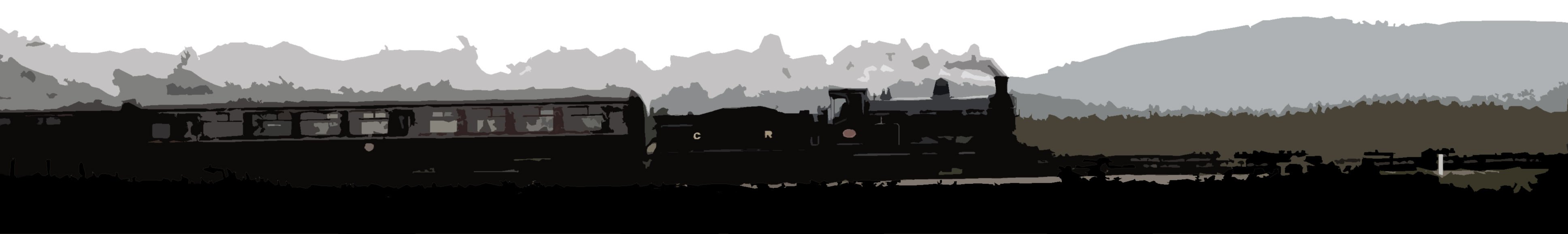
Old photograph showing CR 123 leaving Galashiels with a special. Can anyone provide any info regarding the date and the train involved?

[Added 28 July 2019.]
Now resolved - see image 69738.

Answers

Having trawled the Six Bells Junction website's Railtour files there are scant details of a "Caledonian 123 Excursion" from Edinburgh to Carlisle and back on 30/8/1958. There are no route details, but as it seems to have been from Princes St then it's more likely to have used the CR main line.
Unmistakably Gala.
I'll read the question properly in future.
D'oh!
It could be the special run by the Edinburgh model railway club in late 1958, which I recall ran out over the Peebles line.
The same picture appears in the Middleton Press album 'Peebles Loop' by Roger Darsley and Dennis Lovett. It is dated 13 September 1958, the rail tour being organised by the Edinburgh & Lothian Miniature Railway Club. It is recorded has travelling to Galashiels via Peebles and returning to Edinburgh by the Waverley Route, The image in the book was taken by D Welsh and is part of Bruce McCartney's collection.


Just to confirm you are a person and not an automated computer system, please type the name of the station.

We need your permission to display your comment. Note that your IP address is stored until the message is approved.

Please note that your comment will not appear immediately.


Query 2127


Work in progress... where?
Now resolved - see image 69726.

Answers

I think this may be the new platform works at Dunbar. I passed there this afternoon and was aware of a heap of ballast.
Image 63880 shows the low wall between the main lines and the platform loop which was the former Down platform, similar vegetation and house gable end.


Just to confirm you are a person and not an automated computer system, please type the name of the station.

We need your permission to display your comment. Note that your IP address is stored until the message is approved.

Please note that your comment will not appear immediately.


Query 2126


Entrance to a former station... where?
Now resolved - see image 69717.

Answers

Could be Cloughton on the old Scarbotough to Whitby route - now a very nice restaurant.
Don't know this one, but the architectural style looks very like the Stainmore line.
The old station at Cloughton, just north of Scarborough.


Just to confirm you are a person and not an automated computer system, please type the name of the station.

We need your permission to display your comment. Note that your IP address is stored until the message is approved.

Please note that your comment will not appear immediately.


Query 2125


Train approaching... where and when?
Now resolved - see image 69692.

Answers

Leaving Stirling northbound passing Shore Road sheds in the mid 1950s?
Could be Perth - southbound shortly after leaving the station around 1950.
Wild surmise, Beattock in the mid 50s?
Could it be a train leaving the south end of Perth in the 50s?


Just to confirm you are a person and not an automated computer system, please type the name of the station.

We need your permission to display your comment. Note that your IP address is stored until the message is approved.

Please note that your comment will not appear immediately.


Query 2124


Waiting for a train... where?
Now resolved - see image 69667.

Answers

Worcester Shrub Hill, see photo 64699.
Worcester, Shrub Hill.


Just to confirm you are a person and not an automated computer system, please type the name of the station.

We need your permission to display your comment. Note that your IP address is stored until the message is approved.

Please note that your comment will not appear immediately.


Query 2123


Passing freight... where and when?
Now resolved - see image 69654.

Answers

The poles and background hills suggest the southern approach to Perth in the mid 1950s.
Freight is in the down loop on the approach to Perth station. Would say 1956 approx.


Just to confirm you are a person and not an automated computer system, please type the name of the station.

We need your permission to display your comment. Note that your IP address is stored until the message is approved.

Please note that your comment will not appear immediately.


Query 2122


Platform scene... where?
Now resolved - see image 69630.

Answers

Manningtree on the Great Eastern main line, looking west towards London.


Just to confirm you are a person and not an automated computer system, please type the name of the station.

We need your permission to display your comment. Note that your IP address is stored until the message is approved.

Please note that your comment will not appear immediately.


Query 2121


View over a former station... where?
Now resolved - see image 69613.

Answers

Killywhan in Dumfries & Galloway looking towards Dumfries.
Killywhan on the Dumfries to Castle Douglas line, looking east. See photo 12945.
Is it Abernethy on the Perth-Ladybank line? Just a long shot!
Looks like Killywhan on the Port Road between Dumfries and Dalbeattie.


Just to confirm you are a person and not an automated computer system, please type the name of the station.

We need your permission to display your comment. Note that your IP address is stored until the message is approved.

Please note that your comment will not appear immediately.


Query 2120


Freight approaching... where and when?
Now resolved - see image 69590.

Answers

West end of Shields Road station - as in image 60430 but about 10 years later. Train is on the St Enoch line, presumably having run via Saltmarket and Gorbals Jcts.
I'm going to hazard a guess that this is on the City of Glasgow Union line near Shields Station, probably mid- to late-1950s, given the number of steel-bodied mineral wagons in the train.
Judging by the bracket signal behind the train, I reckon this is the west end of Shields Road Station, the train heading west off the CoGUR lines from Gorbals Junction, date possibly mid- to late- 1950s.


Just to confirm you are a person and not an automated computer system, please type the name of the station.

We need your permission to display your comment. Note that your IP address is stored until the message is approved.

Please note that your comment will not appear immediately.


Query 2119


Train approaching... where and when?
Now resolved - see image 69562.

Answers

Taking the Strathmore line at Kinnaber Junction in the late 1950s.
Looks to me like Kinnaber Junction, the train taking the Bridge of Dun line bound for Forfar and beyond. Reckon this would be late 1950s or early 1960s, before the A4s took over on the Aberdeen expresses.
Up train taking the Strathmore route at Kinnaber Junction, early/mid 1950s?
Taking the Forfar line at Kinnaber Junction, possibly late 1950s / early 1960s before the down home signal was replaced by a shorter tubular post on the left side of the down main?


Just to confirm you are a person and not an automated computer system, please type the name of the station.

We need your permission to display your comment. Note that your IP address is stored until the message is approved.

Please note that your comment will not appear immediately.


Query 2118


A passing DMU... where and when?
Now resolved - see image 69541.

Answers

My first thought with this photo was that it was between Bucksburn & Persley with a Cravens DMU heading towards Aberdeen. The factory on the left reminds me of Twin Spires Creamery.but the chimney in the background looks too far to the right to be at Mugiemoss paper mill.
The DMU looks like it has just run past the Twin Spires Creamery at Bucksburn. Date sometime in the early 1960s.


Just to confirm you are a person and not an automated computer system, please type the name of the station.

We need your permission to display your comment. Note that your IP address is stored until the message is approved.

Please note that your comment will not appear immediately.


Query 2117


Trackbed preparations... where and when?
Now resolved - see image 69527.

Answers

Looks like the northern approach to Newtongrange during preparation work on the Borders line in 2009/2010?
This could be the Airdrie to Bathgate route reinstatement in progress around 2010 or 2011. Possibly just east of the old Drumgelloch station.
The old Waverley route just to the north of Galashiels during construction of the Borders line?


Just to confirm you are a person and not an automated computer system, please type the name of the station.

We need your permission to display your comment. Note that your IP address is stored until the message is approved.

Please note that your comment will not appear immediately.


Query 2116


Freight passing through... where and when?
Now resolved - see image 69497.

Answers

Pitcaple station on the GNSR main line, looking north east c1960.
I Believe this is Lumphanan Station on The Aberdeen Ballater Line.
Westbound through Pincaple in the 1960s.
I think this is somewhere along the Deeside line.
Definitely former GNSR territory and from the location of the signal box and the siding just visible opposite, it looks like Pitcaple, I would guess it must be early 1960s, shortly after the EE Type 1s arrived and when there was still enough traffic to form such a lengthy freight!
I think it is Pitcaple station in the mid 1960s.


Just to confirm you are a person and not an automated computer system, please type the name of the station.

We need your permission to display your comment. Note that your IP address is stored until the message is approved.

Please note that your comment will not appear immediately.


Query 2115


Train approaching... where and when?
Now resolved - see image 69475.

Answers

Heading out of Aberdeen passing through Kittybrewster - say the late 1950s?
Train leaving Aberdeen in the 1950s passing through Kittybrewster.


Just to confirm you are a person and not an automated computer system, please type the name of the station.

We need your permission to display your comment. Note that your IP address is stored until the message is approved.

Please note that your comment will not appear immediately.


Query 2114


View towards a junction... where and when?
Now resolved - see image 69448.

Answers

Almondbank, looking east towards Perth in the early 60s. The station is behind the camera. The line through the gate served the Royal Naval Store Depot and in earlier times the Huntingtower and Pitcairnfield bleachworks.
Could be the entrance to the Naval Stores siding at Almondbank circa 1960.
It looks like the branch entrance to the Royal Naval stores depot just beyond Almondbank - late 1950s perhaps?


Just to confirm you are a person and not an automated computer system, please type the name of the station.

We need your permission to display your comment. Note that your IP address is stored until the message is approved.

Please note that your comment will not appear immediately.


Query 2113


Freight approaching... where and when?
Now resolved - see image 69434.

Answers

Bucksburn, looking south east towards Aberdeen, taken from Goodhope Road bridge c1960.
Passing through Bucksburn in the 1960s.


Just to confirm you are a person and not an automated computer system, please type the name of the station.

We need your permission to display your comment. Note that your IP address is stored until the message is approved.

Please note that your comment will not appear immediately.


Query 2112


Train approaching... where and when?
Now resolved - see image 69406.

Answers

Could be to the south of Muirend with the Clarkston East line on the left, say 1952?
Could it be on the Down Main at Aberlady Junction? .
Claydon LNE Junction on Oxford to Bletchley line in the 1940s, perhaps?
Could it be the southern approach to Muirend station in the mid 1950s?


Just to confirm you are a person and not an automated computer system, please type the name of the station.

We need your permission to display your comment. Note that your IP address is stored until the message is approved.

Please note that your comment will not appear immediately.


Query 2111


Side by side... where?
Now resolved - see image 69380.

Answers

The sidings at Worcester Shrubhill?
Just outside Worcester Shrub Hill station, to the south. The footpath to the signal box can be seen on the bottom right.


Just to confirm you are a person and not an automated computer system, please type the name of the station.

We need your permission to display your comment. Note that your IP address is stored until the message is approved.

Please note that your comment will not appear immediately.


Query 2110


Walking along a trackbed... where?
Now resolved - see image 69367.

Answers

The trackbed of the SB&B approaching Symington. The A72 runs parallel off to the left.
That could be Benrinnes in the background. Somewhere on the Strathspey - Advie or Ballindalloch, possibly.
I think we are looking towards Symington (just beyond the trees in the middle distance) on the trackbed of the line from Biggar.
Is it on the trackbed of the NB line from Stirling to Balloch by any chance.?
Looks like Tinto hill in the background so approach to Symington from Biggar.
Is that looking West towards Tinto on the Symington, Biggar and Peebles Railway where it runs alongside the A72 on the Eastern outskirts of Symington?


Just to confirm you are a person and not an automated computer system, please type the name of the station.

We need your permission to display your comment. Note that your IP address is stored until the message is approved.

Please note that your comment will not appear immediately.


Query 2109


Stopping train... where and when?
Now resolved - see image 69336.

Answers

The old station at Throsk, looking south through the road bridge with the line into Bandeath depot in the foreground. Possibly a Larbert to Alloa train - say around 1950?
Throsk, early 1950s.
Throsk on the Larbert to Alloa line, looking south in the mid 50s. See photo 35376.
This is Throsk with the train heading in the direction of the swing bridge over the Forth and Alloa. The branch to RNAD Bandeath curves to the right in the foreground. Date looks to be early 1950s.


Just to confirm you are a person and not an automated computer system, please type the name of the station.

We need your permission to display your comment. Note that your IP address is stored until the message is approved.

Please note that your comment will not appear immediately.


Query 2108


About to cross a viaduct... where?
Now resolved - see image 69309.

Answers

Dighty Viaduct in Birkhill,Dundee over the Dighty Burn
Comrie Dean Viaduct, looking east towards Blairhall Junction and Oakley.
Bilston Glen Viaduct in Midlothian
I think this is the Dean Viaduct on the old Stirling and Dunfermline route.


Just to confirm you are a person and not an automated computer system, please type the name of the station.

We need your permission to display your comment. Note that your IP address is stored until the message is approved.

Please note that your comment will not appear immediately.


Query 2107


Freight approaching... where and when?
Now resolved - see image 69287.

Answers

Possibly the NB approach to Stirling in the 1950s with the Ochils in the background?
West of Alloa in the 1950s - eastbound.
Approaching Stirling off the S&D route in the early fifties.


Just to confirm you are a person and not an automated computer system, please type the name of the station.

We need your permission to display your comment. Note that your IP address is stored until the message is approved.

Please note that your comment will not appear immediately.


Query 2106


Train arriving... where and when?
Now resolved - see image 69252.

Answers

Cambus on the Stirling to Dunfermline line, looking west in the mid 50s.
Fairly sure this is the old station at Cambus, probably taken in the early 1950s looking west back towards Stirling.


Just to confirm you are a person and not an automated computer system, please type the name of the station.

We need your permission to display your comment. Note that your IP address is stored until the message is approved.

Please note that your comment will not appear immediately.


Query 2105


Work in progress... where?
Now resolved - see image 69237.

Answers

Worcestershire Parkway station, low level platforms, looking north.
Warrington West, maybe.
The new station at Worcestershire Parkway looking north towards Birmingham.


Just to confirm you are a person and not an automated computer system, please type the name of the station.

We need your permission to display your comment. Note that your IP address is stored until the message is approved.

Please note that your comment will not appear immediately.


Query 2104


Station frontage... where?
Now resolved - see image 69226.

Answers

Malton from the car park?
Cupar Station on the north East Coast line between kirkaldy and dundee
The station forecourt at Malton, looking east.


Just to confirm you are a person and not an automated computer system, please type the name of the station.

We need your permission to display your comment. Note that your IP address is stored until the message is approved.

Please note that your comment will not appear immediately.


Query 2103


Platform scene... where and when?
Now resolved - see image 69198.

Answers

Looks like Connel Ferry, probably a train for Ballachulish, say 1959?
Ballachulish Branch train at Connel Ferry, circa mid-1950s. Locomotive, probably No. 55124, tying on at the west end of the station after running round.
Connel Ferry - circa 1961 ?
Connel Ferry station, looking east c1960.
Killin junction some time back in the 50s


Just to confirm you are a person and not an automated computer system, please type the name of the station.

We need your permission to display your comment. Note that your IP address is stored until the message is approved.

Please note that your comment will not appear immediately.


Query 2102


Passing train... where?
Now resolved - see image 69186.

Answers

On the Chester to Holyhead line about 1.5 miles north east of Penmaemawr, looking west. The class 158 is in the new Transport for Wales livery.
North Wales beside the A55 with the village of Dwygyfylchi to the left and further left, Penmaenmawr. TfW Class 158 heading east towards Conwy.
Transport for Wales liveried 158 on the North Wales Coast line
On the North Wales Coast, looks like it could be heading towards Abergele.


Just to confirm you are a person and not an automated computer system, please type the name of the station.

We need your permission to display your comment. Note that your IP address is stored until the message is approved.

Please note that your comment will not appear immediately.


Query 2101


Freight approaching... where and when?
Now resolved - see image 69172.

Answers

Could be the northern approach to Stirling in the 1950s.
Passing Polmadie westbound, probably around 1952?
Stirling 1950s?


Just to confirm you are a person and not an automated computer system, please type the name of the station.

We need your permission to display your comment. Note that your IP address is stored until the message is approved.

Please note that your comment will not appear immediately.


Query 2100


Former station master's house... where?
Now resolved - see image 69150.

Answers

It looks like the house on the end of the building that was once West Cliff station in Whitby.


Just to confirm you are a person and not an automated computer system, please type the name of the station.

We need your permission to display your comment. Note that your IP address is stored until the message is approved.

Please note that your comment will not appear immediately.


Query 2098


Passing light engine... where and when?
Now resolved - see image 69125.

Answers

Could this be somewhere near Deansgate prior to the massive regeneration work in that part of Manchester?
Approaching Saltley in the early 1980s?
Saltley looking west with Curzon St station in the background. Probably mid- to late-70s.
Could this view be near Carlisle (Duranhill!) with the Class 25 on the S&C line, the Tyne Valley lines seen beyond, and the wagons in the background stabled on the old goods yard sidings ?
I am wondering what the building in the top left is. Reminds me of Manchester Central but the rest of the landscape doesn't seem to fit in. I need to do some more research!
I think the buildings could be part of Coatbridge in the 1970s with the view being east over the sidings at Whifflet.


Just to confirm you are a person and not an automated computer system, please type the name of the station.

We need your permission to display your comment. Note that your IP address is stored until the message is approved.

Please note that your comment will not appear immediately.


Query 2097


Passing railbus... where and when?
Now resolved - see image 69089.

Answers

Could it be Elgin East?
Elgin East, looking north east with Maisondieu Road in the background c.1960.
The railbus is approaching Elgin East station. This would have been taken towards the end of the 1950s.


Just to confirm you are a person and not an automated computer system, please type the name of the station.

We need your permission to display your comment. Note that your IP address is stored until the message is approved.

Please note that your comment will not appear immediately.


Query 2095


Disused station... where?
Now resolved - see image 69074.

Answers

Canonbie station on the Langholm branch, looking north west.
This looks like the much changed Canonbie station on the Langholm branch looking north from the main road towards Langholm.


Just to confirm you are a person and not an automated computer system, please type the name of the station.

We need your permission to display your comment. Note that your IP address is stored until the message is approved.

Please note that your comment will not appear immediately.


Query 2094


Voyager approaching... where?
Now resolved - see image 69061.

Answers

Wishaw South
Motherwell
Holytown Junction?


Just to confirm you are a person and not an automated computer system, please type the name of the station.

We need your permission to display your comment. Note that your IP address is stored until the message is approved.

Please note that your comment will not appear immediately.


Query 2093


Passing freight... where?
Now resolved - see image 69033.

Answers

Taken at Woodbridge Park station looking east towards Barking.


Just to confirm you are a person and not an automated computer system, please type the name of the station.

We need your permission to display your comment. Note that your IP address is stored until the message is approved.

Please note that your comment will not appear immediately.


Query 2091


A former railway bridge... where?
Now resolved - see image 69022.

Answers

It's the bridge over the former Monkland Canal at Sheepford.
Could it be Coatbridge, alongside the old Monkland Canal (now a cycle route)?
The old M&K railway bridge at Sheepford. The cycle path was part of the Monkland Canal.


Just to confirm you are a person and not an automated computer system, please type the name of the station.

We need your permission to display your comment. Note that your IP address is stored until the message is approved.

Please note that your comment will not appear immediately.


Query 2090


Passing freight... where and when?
Now resolved - see image 69001.

Answers

Shore Road, Stirling, around 1950.
Wonder if it could be Shore Road to the north of Stirling station around 1950?


Just to confirm you are a person and not an automated computer system, please type the name of the station.

We need your permission to display your comment. Note that your IP address is stored until the message is approved.

Please note that your comment will not appear immediately.


Query 2089


Platform view... where?
Now resolved - see image 68968.

Answers

Mangapps station at the Mangapps Railway Museum in Essex.
Mangapps
It's the Mangapps Museum line station in Essex.


Just to confirm you are a person and not an automated computer system, please type the name of the station.

We need your permission to display your comment. Note that your IP address is stored until the message is approved.

Please note that your comment will not appear immediately.


Query 2088


Steam hauled... where and when?
Now resolved - see image 68953.

Answers

Glasgow/Busby or East Kilbride train leaving Giffnock hauled by ex-Caledonian 0-4-4 tank - mid 1950s.
Leaving Giffnock for Busby in the 1950s.


Just to confirm you are a person and not an automated computer system, please type the name of the station.

We need your permission to display your comment. Note that your IP address is stored until the message is approved.

Please note that your comment will not appear immediately.


Query 2087


Former station approach... where?
Now resolved - see image 68943.

Answers

This is the driveway approaching Amisfield, north of Dumfries
Amisfield


Just to confirm you are a person and not an automated computer system, please type the name of the station.

We need your permission to display your comment. Note that your IP address is stored until the message is approved.

Please note that your comment will not appear immediately.


Query 2086


View from a closed station... where?
Now resolved - see image 68885.

Answers

I think it might possibly be the northern portal of Crescent Wood Tunnel on the old Crystal Palace High Level branch from Nunhead that, despite being electrified, was abandoned in 1954.
It could be North Portal of Scotland St Tunnel in Edinburgh
Monmouth Troy, looking west.
Is it on the old harbour branch at Tweedmouth?
Definitely Monmouth Troy, I think.
Yes, it's the tunnel immediately to the west of the old Troy station in Monmouth. I believe the tunnel is currently used as a rifle range by a local club.


Just to confirm you are a person and not an automated computer system, please type the name of the station.

We need your permission to display your comment. Note that your IP address is stored until the message is approved.

Please note that your comment will not appear immediately.


Query 2085


Platform view... where?
Now resolved - see image 68874.

Answers

Possibly the rebuilt Northumberland Park station on the Lea Valley line in North London?
Agree with Northumberland Park on the Lea Valley line in North London. Seen following the rebuild to handle the new Stratford - Meridian Water shuttle service - looking north along the newly laid third line.


Just to confirm you are a person and not an automated computer system, please type the name of the station.

We need your permission to display your comment. Note that your IP address is stored until the message is approved.

Please note that your comment will not appear immediately.


Query 2084


Remnant of a bygone line... where?
Now resolved - see image 68845.

Answers

Rothbury in Northumberland. It's in the town centre, not at the station site, which was about a quarter of a mile away.
Its in Rothbury - the Hotel is on the other side of the river from the station site, which is now an industrial area.
Appleby ?
Bridge Street, Rothbury, Northumberland. Rothbury station, which was opened by the Northumberland Central Railway in 1862, was the terminus of a branch from Scotsgap on the Morpeth to Reedsmouth line. The line was worked from the outset by the North British Railway and later absorbed by them. Subsequently it became part of the LNER and then the North Eastern Region of British Railways. Passenger trains ceased in September 1952, and goods services ended in November 1963. A final train ran in the middle of 1964 and the track was lifted later that year. Today almost nothing remains of the railway station.
A possible explanation of the Railway Hotel being so far away from the station and on the other side of the river is that the line to Rothbury was originally planned to extend northwards through Wooler to Cornhill. So the Railway Hotel, which was built in Victorian times, might have been named after a section of railway which in the event did not materialise.


Just to confirm you are a person and not an automated computer system, please type the name of the station.

We need your permission to display your comment. Note that your IP address is stored until the message is approved.

Please note that your comment will not appear immediately.


Query 2083


Steam hauled freight... where and when?
Now resolved - see image 68820.

Answers

Forfar North Junction, looking west in the mid 50s.
Fairly sure this is Forfar North Junction in about 1952.


Just to confirm you are a person and not an automated computer system, please type the name of the station.

We need your permission to display your comment. Note that your IP address is stored until the message is approved.

Please note that your comment will not appear immediately.


Query 2082


Train approaching... where and when?
Now resolved - see image 68792.

Answers

On the Paisley Canal Line between Mosspark West and Corkerhill in the mid 50s. Looking east from Kinnell Place bridge with the White Cart Water on the right.
Westbound for Paisley Canal just west of Corkerhill, I reckon, mid- to late-1950s
Just passed through Corkerhill alongside the White Cart? Poss around 1958?


Just to confirm you are a person and not an automated computer system, please type the name of the station.

We need your permission to display your comment. Note that your IP address is stored until the message is approved.

Please note that your comment will not appear immediately.


Query 2081


View from a train... where?
Now resolved - see image 68781.

Answers

Is this Melling between Carnforth and Wennington?
It could be Melling in Cumbria on the line from Carnforth to Hellifield. Has been closed for many years and is now a private house.


Just to confirm you are a person and not an automated computer system, please type the name of the station.

We need your permission to display your comment. Note that your IP address is stored until the message is approved.

Please note that your comment will not appear immediately.


Query 2080


Former railway viaduct... where?
Now resolved - see image 68767.

Answers

Looks like the ex-NER Newton Cap Viaduct to the north of Bishop Auckland, which now carries the main road into the town.
This looks like the Newton Cap viaduct over the River Wear on the north side of Bishop Auckland, now used by a road, possibly the A689.
Looks like the one at Newton Cap, Bishop Auckland in Durham.
No question of 'looks like', it is indeed Newton Cap Viaduct. Might be worth adding some details from the rebuilding project. Closed to trains in 1968. Became a footpath in 1972. Work to convert into a road bridge began in 1993 and was completed in 1995. The conversion involving putting a concrete deck some 13 feet wider than the viaduct on top of the existing structure. The deck provides a single road carriageway with footpaths on each side. The viaduct is 828 feet long, and its stone/brick construction was deemed strong enough to safely take the additional load of the concrete deck. The deck added 2% to the weight of the viaduct bringing it up to 48,000 tonnes. The conversion is said to be the first of its type in the UK.


Just to confirm you are a person and not an automated computer system, please type the name of the station.

We need your permission to display your comment. Note that your IP address is stored until the message is approved.

Please note that your comment will not appear immediately.


Query 2079


Train approaching... where and when?
Now resolved - see image 68748.

Answers

Coupar Angus, looking west, possibly on 5/4/53 as the train could be the same one as in photo 68017. The maltings building can be seen the background of photo 24848.
Possibly Coupar Angus with a local train off the Blairgowrie branch approaching? Say early 1950s.
Could this be the southern approach to Coupar Angus station, with a local passenger service from Blairgowrie approaching the outer face of the ‘Down’ island platform? Possible date, say early to mid-1950s.


Just to confirm you are a person and not an automated computer system, please type the name of the station.

We need your permission to display your comment. Note that your IP address is stored until the message is approved.

Please note that your comment will not appear immediately.


Query 2078


View from a train... where?
Now resolved - see image 68729.

Answers

The viaduct or causeway over the reservoir at Butterley on the Midland Railway in Derbyshire.
The causeway over Butterley Reservoir on the Midland Railway Trust's line between Hammersmith and Butterley, looking east.
Crossing the causeway with Butterley Reservoir on the left; looking back towards the Midland Railway Centre's Butterley station.
Butterley Reservoir on the Midland Railway Trust


Just to confirm you are a person and not an automated computer system, please type the name of the station.

We need your permission to display your comment. Note that your IP address is stored until the message is approved.

Please note that your comment will not appear immediately.


Query 2077


Former goods shed... where?
Now resolved - see image 68716.

Answers

Castle Cary, looking west from the station car park. The line to Yeovil goes under the road bridge on the left while the main line to Cogload Jct is in the middle and the remaining siding is nearest the camera.
Castle Cary in Somerset, looking west.
Castle Cary?
Yes it is Castle Cary. It's been like this for quite some time now. I was told by a member of the station staff that bats were discovered nesting there after demolition started so work was stopped and it has been in this state ever since.


Just to confirm you are a person and not an automated computer system, please type the name of the station.

We need your permission to display your comment. Note that your IP address is stored until the message is approved.

Please note that your comment will not appear immediately.


Query 2073


Freight only branch in the 1990s... where?
Now resolved - see image 68678.

Answers

I reckon this is James Watt Dock molasses siding in Greenock, the line up to the main line curving left to cross the A8 on the viaduct, the line straight ahead the rump of the dock sidings network that terminated at the molasses loading point alongside the tanks visible in the background.
James Watt Dock branch in Greenock, looking west, see photo 42723.
Dalmuir Riverside?


Just to confirm you are a person and not an automated computer system, please type the name of the station.

We need your permission to display your comment. Note that your IP address is stored until the message is approved.

Please note that your comment will not appear immediately.


Query 2072


Platform scene... where?
Now resolved - see image 68664.

Answers

This looks very similar to Whitstable except it was a dull wet day when I visited.


Just to confirm you are a person and not an automated computer system, please type the name of the station.

We need your permission to display your comment. Note that your IP address is stored until the message is approved.

Please note that your comment will not appear immediately.


Query 2070


Steam hauled... where and when?
Now resolved - see image 68640.

Answers

From the landscape and the locomotive it would most likely be the Edinburgh to Aberdeen main line in the mid 1950s.
Just a bit of a guess but could this be a down express near Gleneagles in the early to mid 50s?
I think this could be a northbound Waverley route service, having departed Carlisle and just crossed the River Eden, probably mid-1950s.
Possibly in the "wild guess" category, but could it be an Up express approaching Inverkeithing North Junction in the 1950s?
.... I made a "triangulation error" in my wild guess - I meant to write Inverkeithing East Junction!
Running into Ladybank?
Agree with original suggestion - would suggest the southern approach to Stonehaven around 1955/56.
As you were - I meant norther approach.
Could be Almond Valley Junction, looking south east towards Perth in the mid 50s, before the New Yard was built.


Just to confirm you are a person and not an automated computer system, please type the name of the station.

We need your permission to display your comment. Note that your IP address is stored until the message is approved.

Please note that your comment will not appear immediately.


Query 2069


A former station... where?
Now resolved - see image 68611.

Answers

Looks like the level crossing at Picton on the Northallerton to Teesside line.
The old station at Picton in North Yorkshire looking west.
Picton, on the Northallerton to Eaglescliffe line, looking west. See photo 21417.
Picton, North Yotks


Just to confirm you are a person and not an automated computer system, please type the name of the station.

We need your permission to display your comment. Note that your IP address is stored until the message is approved.

Please note that your comment will not appear immediately.


Query 2068


Station frontage... where?
Now resolved - see image 68584.

Answers

Chislehurst
Entrance to Chilslehurst station seen from Station Approach.


Just to confirm you are a person and not an automated computer system, please type the name of the station.

We need your permission to display your comment. Note that your IP address is stored until the message is approved.

Please note that your comment will not appear immediately.


Query 2064


Train approaching... where?
Now resolved - see image 68567.

Answers

That's an eastward view at Croy, I think.
Approaching Croy station from the east?


Just to confirm you are a person and not an automated computer system, please type the name of the station.

We need your permission to display your comment. Note that your IP address is stored until the message is approved.

Please note that your comment will not appear immediately.


Query 2063


Train departure... where and when?
Now resolved - see image 68556.

Answers

St Fillans on the Crieff to Balquidder line, looking west c1950.
St Fillans 1950ish
Suggest St Fillans in the early 1950s with a train leaving for Crieff.


Just to confirm you are a person and not an automated computer system, please type the name of the station.

We need your permission to display your comment. Note that your IP address is stored until the message is approved.

Please note that your comment will not appear immediately.


Query 2062


A former station... where?
Now resolved - see image 68534.

Answers

This looks familiar, North Grimston on the former Malton to Driffield line. View from what would have been the level crossing with Malton to the right.
The second station at North Grimston on the Malton - Driffield line.


Just to confirm you are a person and not an automated computer system, please type the name of the station.

We need your permission to display your comment. Note that your IP address is stored until the message is approved.

Please note that your comment will not appear immediately.


Query 2061


End of the line... where?
Now resolved - see image 68518.

Answers

Just a wild guess - I remember a similar scene at Wolverhampton on the former GW line some years ago.
This reminds me of the remains of the old Longridge branch behind West View Liesure Centre in Preston.


Just to confirm you are a person and not an automated computer system, please type the name of the station.

We need your permission to display your comment. Note that your IP address is stored until the message is approved.

Please note that your comment will not appear immediately.


Query 2060


Freight approaching... where and when?

[Added 21 April 2019.]
Now resolved - see image 68501.

Answers

I think this could be Cardonald Junction around the mid 1950s, with the freight coming off the old Shieldhall branch.
Could it be Shieldhall Junction in the 1950s?
Cardonald Junction on the Glasgow & Paisley Joint, looking west with the train coming off the Renfrew District line in the mid 50s.
Cart Junction, around 1955?


Just to confirm you are a person and not an automated computer system, please type the name of the station.

We need your permission to display your comment. Note that your IP address is stored until the message is approved.

Please note that your comment will not appear immediately.


Query 2057


Platform view... where?
Now resolved - see image 68480.

Answers

Looks like the station building at Oakleigh Park, North London.


Just to confirm you are a person and not an automated computer system, please type the name of the station.

We need your permission to display your comment. Note that your IP address is stored until the message is approved.

Please note that your comment will not appear immediately.


Query 2056


Unloading in progress... where?
Now resolved - see image 68467.

Answers

The cement terminal at Seaham Harbour.


Just to confirm you are a person and not an automated computer system, please type the name of the station.

We need your permission to display your comment. Note that your IP address is stored until the message is approved.

Please note that your comment will not appear immediately.


Query 2054


Train approaching... where and when?
Now resolved - see image 68447.

Answers

Branch train leaving Gleneagles for Crieff in the early 1950s.
Could it be the north end of Gleneagles?


Just to confirm you are a person and not an automated computer system, please type the name of the station.

We need your permission to display your comment. Note that your IP address is stored until the message is approved.

Please note that your comment will not appear immediately.


Query 2053


Old signal box... where?
Now resolved - see image 68414.

Answers

Helmsley on the Gilling to Pickering line, looking west. See photo 55155.
Helmsley. A view I had intended to take early last year, but with events that overtook everything else I was still needing to go back for the lineside view. See image 55155.
Could be Helmsley in North Yorkshire - the old station still stands off to the right as a large private house.


Just to confirm you are a person and not an automated computer system, please type the name of the station.

We need your permission to display your comment. Note that your IP address is stored until the message is approved.

Please note that your comment will not appear immediately.


Query 2052


Steam approaching... where and when?
Now resolved - see image 68392.

Answers

Clarkston on the East Kilbride line, looking north west in the 50s.
Glasgow/Busby or East Kilbride train entering Clarkston & Stamperland in the 1950s.
I think this could be an inner circle train on the Edinburgh Suburban line between Gorgie and Craiglockhart, possibly passing Craiglockhart Junction. Date circa 1955.


Just to confirm you are a person and not an automated computer system, please type the name of the station.

We need your permission to display your comment. Note that your IP address is stored until the message is approved.

Please note that your comment will not appear immediately.


Query 2050


A view from a train... where?
Now resolved - see image 68380.

Answers

Possibly the recently opened facilities just south of Banbury?
Banbury Depot


Just to confirm you are a person and not an automated computer system, please type the name of the station.

We need your permission to display your comment. Note that your IP address is stored until the message is approved.

Please note that your comment will not appear immediately.


Query 2049


Train approaching... where?
Now resolved - see image 68353.

Answers

Cambrian Coast line near Barmouth?
Barmouth on the Cambrian Coast Line, looking north-west.
Tywyn, West Wales.
Could it be approaching Barmouth
This looks like the Cambrian Coast line - maybe on the approach to Machynlleth?


Just to confirm you are a person and not an automated computer system, please type the name of the station.

We need your permission to display your comment. Note that your IP address is stored until the message is approved.

Please note that your comment will not appear immediately.


Query 2048


A station from the air... where?
Now resolved - see image 68337.

Answers

I believe it's Datchet, on the Windsor & Eton Riverside branch
Looks like Datchet on the Windsor branch.
Datchet.


Just to confirm you are a person and not an automated computer system, please type the name of the station.

We need your permission to display your comment. Note that your IP address is stored until the message is approved.

Please note that your comment will not appear immediately.


Query 2047


Train approaching... where and when?
Now resolved - see image 68327.

Answers

Heading north on the main line out of Stirling, late 1940s / early 1950s.
Wondered if it might be Stirling in the 1950s with the train heading for Alloa / Dunfermline via the S&D line?


Just to confirm you are a person and not an automated computer system, please type the name of the station.

We need your permission to display your comment. Note that your IP address is stored until the message is approved.

Please note that your comment will not appear immediately.


Query 2046


About to pass over a level crossing... where?
Now resolved - see image 68313.

Answers

It's the A40 at Llandovery - looks like a northbound excursion about tp cross.
Northbound through Llandovery, about to cross the A40.
Llandovery on the Central Wales Line, looking north east. Could be the 'Heart of Wales' tour on 2/9/17 with 68 016 and the Northern Belle stock.
The A40 level crossing at the north end of Llandovery station.
Is this Llandovery looking north.?


Just to confirm you are a person and not an automated computer system, please type the name of the station.

We need your permission to display your comment. Note that your IP address is stored until the message is approved.

Please note that your comment will not appear immediately.


Query 2045


Train arriving... where?
Now resolved - see image 68299.

Answers

Disley station on the Stockport to Buxton line, looking east.
Disley
Arrival at Disley on the Buxton line.


Just to confirm you are a person and not an automated computer system, please type the name of the station.

We need your permission to display your comment. Note that your IP address is stored until the message is approved.

Please note that your comment will not appear immediately.


Query 2044


Passing coal empties... where?
Now resolved - see image 68285.

Answers

Edinburgh's South Sub - westbound near Cluny Road bridge.
Edinburgh suburban line between Blackford Hill and Morningside Road


Just to confirm you are a person and not an automated computer system, please type the name of the station.

We need your permission to display your comment. Note that your IP address is stored until the message is approved.

Please note that your comment will not appear immediately.


Query 2043


Passing Freight... where?
Now resolved - see image 68272.

Answers

Nuneaton
About to pass through Nuneaton?


Just to confirm you are a person and not an automated computer system, please type the name of the station.

We need your permission to display your comment. Note that your IP address is stored until the message is approved.

Please note that your comment will not appear immediately.


Query 2041


Passing train... where?
Now resolved - see image 68265.

Answers

Looks like a train eastbound through Ashton-under-Lyne station.
Ashton-under-Lyne
Ashton-under-Lyne looking east along platform 2.


Just to confirm you are a person and not an automated computer system, please type the name of the station.

We need your permission to display your comment. Note that your IP address is stored until the message is approved.

Please note that your comment will not appear immediately.


Query 2040


Passing express... where and when?
Now resolved - see image 68234.

Answers

Stanley Junction, looking north east, c1950.
I believe this is Harburn Station on the Carstairs section Midcalder Jct to Cobbinshaw prior to 1964 before Closure.
Passing Stanley Junction southbound in the early to mid 1950s.


Just to confirm you are a person and not an automated computer system, please type the name of the station.

We need your permission to display your comment. Note that your IP address is stored until the message is approved.

Please note that your comment will not appear immediately.


Query 2039


Cross platform view... where?
Now resolved - see image 68221.

Answers

The station that comes to mind would be Achnasheen.
Bempton on the Yorkshire Coast Line?
It has a Welsh look to me. I thought it might be Llanfair PG. It isn't, but the building has distinct similarities to Llanfair PG.
It's Garve on the Kyle Line.
Was through it two weeks ago on our bug highland rail tour.
Have a look at http://www.scottishhills.com/html/modules.php?name=Forums&file=viewtopic&t=14172
It's Garve station on the Kyle line.


Just to confirm you are a person and not an automated computer system, please type the name of the station.

We need your permission to display your comment. Note that your IP address is stored until the message is approved.

Please note that your comment will not appear immediately.


Query 2037


Train at the platform... where and when?
Now resolved - see image 68200.

Answers

NBR signal and box; single-line branch... I reckon this could be Alva.
Alva, early 1950s maybe.
Mildenhall, Suffolk, early 1950s, perhaps?
Alva?


Just to confirm you are a person and not an automated computer system, please type the name of the station.

We need your permission to display your comment. Note that your IP address is stored until the message is approved.

Please note that your comment will not appear immediately.


Query 2035


Train arriving... where?
Now resolved - see image 68186.

Answers

Manors ?
Manors, I reckon.


Just to confirm you are a person and not an automated computer system, please type the name of the station.

We need your permission to display your comment. Note that your IP address is stored until the message is approved.

Please note that your comment will not appear immediately.


Query 2034


Passing steam... where and when?

Answers

Strathord early 1950s Cally bogie on local train


Just to confirm you are a person and not an automated computer system, please type the name of the station.

We need your permission to display your comment. Note that your IP address is stored until the message is approved.

Please note that your comment will not appear immediately.


Query 2033


Platform scene... where?

[Added 27 March 2019.]
Resolved. See image 68152.

Answers

Canterbury West station, looking south west towards Ashford.
Blackheath?
Canterbury West station with a Javelin at the platform, presumably on a St Pancras - Margate service.


Just to confirm you are a person and not an automated computer system, please type the name of the station.

We need your permission to display your comment. Note that your IP address is stored until the message is approved.

Please note that your comment will not appear immediately.


Query 2017


Steam engine between turns... where and when?
[Added 22 March 2019] NOW RESOLVED - SEE IMAGE 68095

Answers

I think this is a Reid C15 at Stirling's NB Shore Road shed, possibly around 1950.
This might be Dundee Tay Bridge shed yard or thereabouts in every the early 1950s, this impression coming from the skyline behind and what appear to be more locos in the distance (Dundee West shed?)
Could it be the ex-NBR loco sheds just north of Stirling station, perhaps in very early BR days?
The east side of Dundee? Say early 1950s?


Just to confirm you are a person and not an automated computer system, please type the name of the station.

We need your permission to display your comment. Note that your IP address is stored until the message is approved.

Please note that your comment will not appear immediately.


Query 2015


Going for a walk... where?
[Added 20 March 2019] NOW RESOLVED - SEE IMAGE 68071

Answers

Fairly sure this is the Weardale Railway's platform at Bishop Auckland West - presumably at the time of 'fitting out' (around 2008?) The main line station is out of shot in the left background.


Just to confirm you are a person and not an automated computer system, please type the name of the station.

We need your permission to display your comment. Note that your IP address is stored until the message is approved.

Please note that your comment will not appear immediately.


Query 2014


Former junction with lifted branch... where and when?
[Added 19 March 2019] NOW RESOLVED - SEE IMAGE 68049

Answers

Bilston Glen colliery sidings, looking north towards Loanhead. Track bed of former line to Glencorse in the foreground, c1980.
I also believe this is Bilston Glen Colliery.


Just to confirm you are a person and not an automated computer system, please type the name of the station.

We need your permission to display your comment. Note that your IP address is stored until the message is approved.

Please note that your comment will not appear immediately.


Query 2013


Passing a former junction... where and when?
[Added 18 March 2019] NOW RESOLVED - SEE IMAGE 68042

Answers

Glasterlaw Junction on Strathmore mainline. Train heading for Forfar having just passed Glasterlaw station. Early 1950's.
Glasterlaw Junction on the Strathmore line, looking north east with the track bed of the line to Arbroath in the foreground. Taken in the early 50s.
Glasterlaw 1953
Glasterlaw Junction? Around 1955?


Just to confirm you are a person and not an automated computer system, please type the name of the station.

We need your permission to display your comment. Note that your IP address is stored until the message is approved.

Please note that your comment will not appear immediately.


Query 2012


Railway trackbed... where?
[Added 17 March 2019] NOW RESOLVED - SEE IMAGE 68031

Answers

Looks like the old trackbed at Ribbleton looking SW towards the site of Deepdale Junction.
It looks like the Stirling -Dunfermline Line between Townhill and Dunfermline Upper/Touch


Just to confirm you are a person and not an automated computer system, please type the name of the station.

We need your permission to display your comment. Note that your IP address is stored until the message is approved.

Please note that your comment will not appear immediately.


Query 2011


Train approaching... where and when?
[Added 16 March 2019] NOW RESOLVED - SEE IMAGE 68017

Answers

Could this be approaching Coupar Angus with the main line to Stanley Jct on the left and the train coming off the Blairgowrie branch? If the location is correct it could be late 40s or early 50s..
Coupar Angus, train is coming off the Blairgowrie branch, looking west in the early 50s.
Coming of the Blairgowrie branch onto the Strathmore mainline at Coupar Angus. About 1950.


Just to confirm you are a person and not an automated computer system, please type the name of the station.

We need your permission to display your comment. Note that your IP address is stored until the message is approved.

Please note that your comment will not appear immediately.


Query 2010


Steam on shed... where and when?
[Added 14 March 2019] NOW RESOLVED - SEE IMAGE 68001

Answers

Given the loco is an ex-Caley 4-4-0 (72 class), then from the likely sheds it looks most likely to be Forfar. The shed was closed in the early 1960s so I'd put the date at 1958 or 1959.


Just to confirm you are a person and not an automated computer system, please type the name of the station.

We need your permission to display your comment. Note that your IP address is stored until the message is approved.

Please note that your comment will not appear immediately.


Query 2009


A closed station, photographed looking across a field in 20XX... where is this?
[Added 12 March 2019] NOW RESOLVED - SEE IMAGE 67977

Answers

Elrington on the Allendale branch, looking west,


Just to confirm you are a person and not an automated computer system, please type the name of the station.

We need your permission to display your comment. Note that your IP address is stored until the message is approved.

Please note that your comment will not appear immediately.


Query 2008


Engineer's train... where?
[Added 10 March 2019] NOW RESOLVED - SEE IMAGE 67943

Answers

This is the S&C near Stainforth, the train is heading south.
Stainforth, North Yorks?


Just to confirm you are a person and not an automated computer system, please type the name of the station.

We need your permission to display your comment. Note that your IP address is stored until the message is approved.

Please note that your comment will not appear immediately.


Query 2005


Freight passing through... where?
[Added 9 March 2019] NOW RESOLVED - SEE IMAGE 67931

Answers

Looks like the Down Slow at Queen's Park, London end of the WCML?
South Hampstead
The up WCML freight is passing below Loudon Road, NW8, to run through South Hampstead station. It will then continue through Primrose Hill Tunnel and join the North London Line.
Pretty sure the train is northbound - having originated on the NLL.
Oops, sorry about that - it is indeed heading north. (Had my atlas upside down!!) Thanks.


Just to confirm you are a person and not an automated computer system, please type the name of the station.

We need your permission to display your comment. Note that your IP address is stored until the message is approved.

Please note that your comment will not appear immediately.


Query 2004


Steam hauled freight... where and when?
[Added 7 March 2019] NOW RESOLVED - SEE IMAGE 67917

Answers

I wondered if the train might have just crossed the Forth at Stirling heading for Bridge of Allan?


Just to confirm you are a person and not an automated computer system, please type the name of the station.

We need your permission to display your comment. Note that your IP address is stored until the message is approved.

Please note that your comment will not appear immediately.


Query 2003


Freight approaching... where?
[Added 6 March 2019] NOW RESOLVED -SEE IMAGE 67887

Answers

A Coatbridge bound Freightliner Intermodal service heads north through the Ryelands area of Lancaster. The 40 MPH advance speed restriction on the left is for the diverging routes off the Up Main into platforms 4 or 5 at Lancaster.
Could be Lancaster?


Just to confirm you are a person and not an automated computer system, please type the name of the station.

We need your permission to display your comment. Note that your IP address is stored until the message is approved.

Please note that your comment will not appear immediately.


Query 2002


Old station platform with surviving nameboard posts... where?
[Added 5 March 2019] NOW RESOLVED - SEE IMAGE 67875

Answers

Three Cocks Junction?
Remains of Freshwater station, IoW. The main station site is now occupied by a supermarket, behind which is this garden centre.
Freshwater, Isle of Wight, is a potential candidate.


Just to confirm you are a person and not an automated computer system, please type the name of the station.

We need your permission to display your comment. Note that your IP address is stored until the message is approved.

Please note that your comment will not appear immediately.


Query 2001


Tall poles... where is this?
[Added 4 March 2019] NOW RESOLVED - SEE IMAGE 67863

Answers

Near Leith Hall, just west of Kennethmont on the GNSR main line, looking north along the B9002.
This is the B9002 crossing the Inverness - Aberdeen main line west of Kennethmont.
B9002 bridge over Aberdeen to Inverness line near Kennethmont.
I think we are looking north along the B9002, north of Kennethmont village with the former station almost a mile to the east (right).


Just to confirm you are a person and not an automated computer system, please type the name of the station.

We need your permission to display your comment. Note that your IP address is stored until the message is approved.

Please note that your comment will not appear immediately.


Query 2000


Steam on shed in the sixties... where?
[Added 2 March 2019] NOW RESOLVED - SEE IMAGE 67846

Answers

Culter Paper Mill
I think this is Culter paper mill, Aberdeen. The mill closed in the mid 1960s so this was possibly taken around 1959/1960.


Just to confirm you are a person and not an automated computer system, please type the name of the station.

We need your permission to display your comment. Note that your IP address is stored until the message is approved.

Please note that your comment will not appear immediately.


Query 1999


A former signal box... where and when?
[Added 1 March 2019] NOW RESOLVED - SEE IMAGE 67829

Answers

Could be Ardler Junction, with the Dundee via Newtyle branch on the other side of the box - say 1955??
Ardler Junction on the Strathmore Line, looking east. The line to Newtyle can be seen behind the signal box, this was not used following the accident in 1948. Photo possibly taken in the early 1950s.
Could be Ardler Junction on the former Caledinian main line.
Ardler Junction in the 1950s, looking east along the main line.


Just to confirm you are a person and not an automated computer system, please type the name of the station.

We need your permission to display your comment. Note that your IP address is stored until the message is approved.

Please note that your comment will not appear immediately.


Query 1998


A closed station... where and when?
[Added 28 February 2019] NOW RESOLVED - SEE IMAGE 67809

Answers

Ruthven Road station on the Perth to Crieff line, looking east in the 60s.
I think this is Nisbet on the Jedburgh Branch
Ruthven Road, just west of Perth on the old Crieff line - looking east back towards Perth.
Could it be Ruthven Road, the first station out of Perth and before Almondbank on the Perth-Crieff line?


Just to confirm you are a person and not an automated computer system, please type the name of the station.

We need your permission to display your comment. Note that your IP address is stored until the message is approved.

Please note that your comment will not appear immediately.


Query 1997


Train approaching... where and when?
[Added 27 February 2019] NOW RESOLVED - SEE IMAGE 67796

Answers

Approaching Inverkeithing off the Rosyth Dockyard branch - say mid to late 1950s? Possibly a workers' train?
Approaching Inverkeithing station off the Rosyth branch in the 1950s. Inverkeithing South Junction signal box in the right background, see photo 19632.
It's a stopping train from Rosyth Dockyard approaching Inverkeithing Station at Inverkeithing South Junction, probably during the mid-1950s. The train will either continue to Thornton Junction, or reverse at Inverkeithing for Edinburgh.
J35 64505 approaching Inverkeithing with a workmen's train off the Rosyth Dockyard branch - late 1950s. Inverkeithing South Jn signalbox in the background.
Inverkeithing South Junction, when the Rosyth Dockyard branch diverged north of the Boreland Road bridge. The arched bridge on the left formerly spanned the Halbeath wagonway. Probably mid 1950s.
Inverkeithing South Junction with workers train coming off Rosyth Dockyard branch. As KM notes, the bridge to the left crossed the former Halbeath Railway.


Just to confirm you are a person and not an automated computer system, please type the name of the station.

We need your permission to display your comment. Note that your IP address is stored until the message is approved.

Please note that your comment will not appear immediately.


Query 1996


Passing freight... where?
[Added 25 February 2019] NOW RESOLVED - SEE IMAGE 67780. (THERE'S NO PLACE LIKE HOUGHAM!)

Answers

Certain it's the ECML to the south of Doncaster but can't name the precise spot as yet.
It's near Hougham to the south of Newark - thanks to EG for pointer.


Just to confirm you are a person and not an automated computer system, please type the name of the station.

We need your permission to display your comment. Note that your IP address is stored until the message is approved.

Please note that your comment will not appear immediately.


Query 1995


A closed station, photographed in the 1970s... where is this?
[Added 24 February 2019] NOW RESOLVED - SEE IMAGE 67757

Answers

Yarmouth, Isle of Wight.
Yarmouth on the Isle of Wight, looking north east.
The former station at Yarmouth IoW - it now houses a restaurant going by the name of 'Off The Rails' - well worth a visit.


Just to confirm you are a person and not an automated computer system, please type the name of the station.

We need your permission to display your comment. Note that your IP address is stored until the message is approved.

Please note that your comment will not appear immediately.


Query 1994


A stroll past an abandoned platform... where?
[Added 22 February 2019] NOW RESOLVED - SEE IMAGE 67735

Answers

Kilbarchan
Suggest the old L&D station at Bowling, looking east towards Glasgow with the old island platform on the right.
Is it the old station at Coanwood on the Alston branch ?


Just to confirm you are a person and not an automated computer system, please type the name of the station.

We need your permission to display your comment. Note that your IP address is stored until the message is approved.

Please note that your comment will not appear immediately.


Query 1993


A closed station... where and when?
[Added 21 February 2019] NOW RESOLVED - SEE IMAGE 67711

Answers

I think this is Methven, looking towards the buffer stops, probably taken around the time of final closure of the line from Methven Junction in 1965.
Methven, looking north-east in the early 60s.


Just to confirm you are a person and not an automated computer system, please type the name of the station.

We need your permission to display your comment. Note that your IP address is stored until the message is approved.

Please note that your comment will not appear immediately.


Query 1992


Approach to a closed station in 2007... where is this?
[Added 18 February 2019] NOW RESOLVED - SEE IMAGE 67696

Answers

Moy
Not Moy - see photographs of Moy station and S/Ms house from same period on the website.
Tullibardine, looking north-west towards Crieff.
Agree with the Tullibardine suggestion.


Just to confirm you are a person and not an automated computer system, please type the name of the station.

We need your permission to display your comment. Note that your IP address is stored until the message is approved.

Please note that your comment will not appear immediately.


Query 1991


Passing Pendolino... where is this?
[Added 17 February 2019] NOW RESOLVED - SEE IMAGE 67660

Answers

Holts Lane, Poulton-le-Fylde
Holts Lane, Poulton-le-Fylde.
This looks very much line a photo taken from the end of Holts Lane, Poulton-le-Fylde looking north towards Poulton-le-Fylde station. Prior to the electrification there used to be a foot crossing to the right but I seem to recall that it was being closed but I haven't been back to check recently.


Just to confirm you are a person and not an automated computer system, please type the name of the station.

We need your permission to display your comment. Note that your IP address is stored until the message is approved.

Please note that your comment will not appear immediately.


Query 1990


Station entrance... where?
[Added 14 February 2019] NOW RESOLVED - SEE IMAGE 67613

Answers

Wanstead Park on the GOBLIN line, looking north.


Just to confirm you are a person and not an automated computer system, please type the name of the station.

We need your permission to display your comment. Note that your IP address is stored until the message is approved.

Please note that your comment will not appear immediately.


Query 1989


Train approaching... where and when?
[Added 13 February 2019] NOW RESOLVED - SEE IMAGE 67600

Answers

Kennishead, looking west towards Barrhead in the 1950s.
I think this might be Kennishead station looking west towards Barrhead from the Glasgow-bound platform, the crossover and signals for the still open Spiersbridge Branch which would, if memory serves, put the date at say late 1950s (I think the branch closed circa 1960).
Kennishead possibly?


Just to confirm you are a person and not an automated computer system, please type the name of the station.

We need your permission to display your comment. Note that your IP address is stored until the message is approved.

Please note that your comment will not appear immediately.


Query 1988


Old railway viaduct... where?
[Added 9 February 2019] NOW RESOLVED - SEE IMAGE 67584

Answers

Looks to be the Camps viaduct over the Almond on the Camps Branch of the NB line to Pumpherston Oil Works
Not sure about Camps Viaduct - both the stonework and the fencing look different - see image 35980.
Isn't it the viaduct over the Water of Leith, on the CR Leith North & Granton branch, just north of the former Murrayfield station?
Looks a bit.like Glenfarg but if it is the handrail must be a fairly new addition.
Lower Largo maybe?
Coltbridge viaduct at Murrayfield?
Fairly sure this is Comrie Dean Viaduct on the Stirling & Dunfermline route between East Grange and Oakley. Closed with this section of the line in 1982 and since converted to a cycle route.


Just to confirm you are a person and not an automated computer system, please type the name of the station.

We need your permission to display your comment. Note that your IP address is stored until the message is approved.

Please note that your comment will not appear immediately.


Query 1987


Site of a gated level crossing... where is this?
[Added 8 February 2019] NOW RESOLVED - SEE IMAGE 67530

Answers

Hoole, looking east to Longton Bridge with the former station site behind the photographer.
This is the last remnant of the level crossing gates at Station Road, Little Hoole, West Lancashire. Formerly the site of Hoole Station on the West Lancashire Railway route from Southport to Preston. Closed to passengers and goods on 7 September 1964.
Incidentally, on 23 May 1964 Carlisle Kingmoor allocated 72007 'Clan Mackintosh' passed through here at speed at the head of the RCTS 'Ribble-Lune Rail Tour'.


Just to confirm you are a person and not an automated computer system, please type the name of the station.

We need your permission to display your comment. Note that your IP address is stored until the message is approved.

Please note that your comment will not appear immediately.


Query 1986


Steam hauled... where?
[Added 6 February 2019] NOW RESOLVED - SEE IMAGE 67516

Answers

45690 Bahamas test run returning to KWVR from Tyseley, February 5th. Outside Chesterfield, I think???
45596 plus support coach on the way from Tyseley to the KWVR on 5/2 crossing the River Rother passing through Chesterfield.


Just to confirm you are a person and not an automated computer system, please type the name of the station.

We need your permission to display your comment. Note that your IP address is stored until the message is approved.

Please note that your comment will not appear immediately.


Query 1985


Station frontage... where?
[Added 5 February 2019] NOW RESOLVED - SEE IMAGE 67489

Answers

Could be part of Weston-Super-Mare station?
It looks very similar to part of Weston super Mare station building on the up side.
Possibly Great Malvern?
Weston-super-Mare.


Just to confirm you are a person and not an automated computer system, please type the name of the station.

We need your permission to display your comment. Note that your IP address is stored until the message is approved.

Please note that your comment will not appear immediately.


Query 1984


A former station... where?
[Added 4 February 2019] NOW RESOLVED - SEE IMAGE 67474

Answers

The station was Featherstone Park on the Haltwhistle to Alston branch, now part of a popular walking route.
Featherstone Park on the Alston branch, looking south, see photo 31453.
Featherstone Park on the Alston branch?


Just to confirm you are a person and not an automated computer system, please type the name of the station.

We need your permission to display your comment. Note that your IP address is stored until the message is approved.

Please note that your comment will not appear immediately.


Query 1983


Hard working tank engine... where and when?
[Added 3 February 2019] NOW RESOLVED - SEE IMAGE 67464

Answers

Looks like Busby Junction with a freight coming off the branch, probable date around mid 1950s.
Could it be Dalrymple Junction in the 1950s?
This is Busby Junction with a northbound train of empty mineral wagons from Giffnock Quarry coming off the East Kilbride branch on to the GB&K main line hauled by a Polmadie-based ex-Caledonian 782 class 0-6-0 tank. This train propelled its loaded wagons from the south end of Giffnock station Mondays to Fridays around 7 a.m. during the 1950s and early 1960s on to the Giffnock Quarry branch. The wagons contained slag which was used to fill the disused quarry.
I reckon that this might be Busby Junction, the train coming off the line from the East Kilbride direction, photo taken from the signalbox steps looking west and the date say late 1950s.


Just to confirm you are a person and not an automated computer system, please type the name of the station.

We need your permission to display your comment. Note that your IP address is stored until the message is approved.

Please note that your comment will not appear immediately.


Query 1982


Former station house photographed from the trackbed... where is this?
[Added 2 February 2019] NOW RESOLVED - SEE IMAGE 67451

Answers

Leadburn, looking south towards Peebles
Leadburn
Leadburn on the Peebles line, looking south, see photo 22597.
I think this is the old station masters house alongside Leadburn station, the junction on the Peebles Loop with the branch to Dolphinton.


Just to confirm you are a person and not an automated computer system, please type the name of the station.

We need your permission to display your comment. Note that your IP address is stored until the message is approved.

Please note that your comment will not appear immediately.


Query 1981


Steam hauled passenger train... where and when?
[Added 31 January 2019] NOW RESOLVED - REF QUERY 67439

Answers

Milliken Park. Goods Yd off to the left now occupied by a bus depot. Local train probably a St Enoch to Kilmarnock via Dalry service given the loadings c1959. This stretch of railway know as bomb alley was notorious in the box's latter life and you took your life in your hands manning it due to the high vandalism. In fact the box was destroyed by arson on 1st March 1978.


Just to confirm you are a person and not an automated computer system, please type the name of the station.

We need your permission to display your comment. Note that your IP address is stored until the message is approved.

Please note that your comment will not appear immediately.


Query 1980


Class 47 at speed... where and when?
[Added 30 January 2019] NOW RESOLVED - SEE IMAGE 67410

Answers

The buildings in the background were part of RAF Turnhouse (since demolished). Would put the date in 1980s?
I think this could be a nortbound train passing the now demolished buildings at RAF Turnhouse, now Edinburgh Airport. The cable duct would be in the process of installation, probably early 1970s. The photograph is taken from Lennie bridge.
Down express (probably to Aberdeen), passing RAF Turnhouse heading for Dalmeny. Late 1970s


Just to confirm you are a person and not an automated computer system, please type the name of the station.

We need your permission to display your comment. Note that your IP address is stored until the message is approved.

Please note that your comment will not appear immediately.


Query 1979


Platform view... where and when?
[Added 29 January 2019] NOW RESOLVED - SEE IMAGE 67398

Answers

Almondbank station, on the Perth to Crieff line, looking west c1960.
Almondbank, by any chance
It's Almondbank early 60s (nitpicking it's actually Lochty Bridge)
I think this is Almondbank Station on the Prth, Almond Valley & Methven Railway, looking west from the east side of the overbridge carrying the A85. Station itself looks to be closed (nameboard gone, it was obove the platform level windows on the building) so date is after 1951 and the snow on the ground suggests the really harsh winter of 1962/63.
Almondbank
I think it's Almondbank looking towards Methven Junction and Crieff. Late 1950s or 1960s.


Just to confirm you are a person and not an automated computer system, please type the name of the station.

We need your permission to display your comment. Note that your IP address is stored until the message is approved.

Please note that your comment will not appear immediately.


Query 1978


Passing train... where?
[Added 27 January 2019] NOW RESOLVED - SEE IMAGE 67385

Answers

The Calder Valley line?
I would say this location is Haymarket West Jct on the Edinburgh Glasgow Main Line.
Definitely not Haymarket West Junction - would opt more towards the Calder Valley line, but can't find a match!
Between Ferriby and Brough in the East Riding?
I think this is to the east of Skillings Lane, Brough in the East Riding.


Just to confirm you are a person and not an automated computer system, please type the name of the station.

We need your permission to display your comment. Note that your IP address is stored until the message is approved.

Please note that your comment will not appear immediately.


Query 1977


Passing trains... where?
[Added 26 January 2019] NOW RESOLVED - SEE IMAGE 67355

Answers

Wondered about Selby - with the 158 standing in the bay platform?
This looks to be a view at Selby with the 2 Car TPE 170 on an Hull to Manchester service, and the Northern 158 stabled in the south end up bay.
Selby - looking west from the Hull platform.


Just to confirm you are a person and not an automated computer system, please type the name of the station.

We need your permission to display your comment. Note that your IP address is stored until the message is approved.

Please note that your comment will not appear immediately.


Query 1976


Pacer in the mist - where is this?
[Added 25 January 2019] NOW RESOLVED - SEE IMAGE 67340

Answers

I've no real idea, maybe the Alrincham to Chester line via Hale and Knutsford?
Possibly a Leeds - Morecambe train approaching Wennington - fairly recently?
My first thought is Wennington, looking east towards Bentham.
It is one of the former West Yorkshire PTE owned Andrew Barclay class 144 3 car Pacers in Northern rail colours, with what appears to be SYPTE branding, and my punt is that it is running on the Hope Valley line
Wennington - possibly a Leeds - Morecambe train?


Just to confirm you are a person and not an automated computer system, please type the name of the station.

We need your permission to display your comment. Note that your IP address is stored until the message is approved.

Please note that your comment will not appear immediately.


Query 1975


Station approach... where and when?
[Added 24 January 2019] NOW RESOLVED - SEE IMAGE 67326

Answers

Looks like the GNS station at Bucksburn, sometime in the 1950s?
Is this Boat of Garten Station, now operated by the Strathspey Railway?
Bucksburn c1970. See photo 15720.
The old station at Bucksburn, Aberdeen, probably after closure to passenger traffic but still being used for parcels and goods - say around 1960?
My guess is Aviemore but no real idea when.
Looks rather like Ballater, minus the canopy. Late 60s, post-closure, perhaps?
Could be Bucksburn, north west of Aberdeen, just before closure?
I would agree with Bucksburn and with no vehicles parked, after closure so late 1950s.


Just to confirm you are a person and not an automated computer system, please type the name of the station.

We need your permission to display your comment. Note that your IP address is stored until the message is approved.

Please note that your comment will not appear immediately.


Query 1973


Bridge watchers... where and when?
[Added 22 January 2019] NOW RESOLVED - SEE IMAGE 67307

Answers

Friarton signal box in the south of Perth, looking north from Breadalbane Terrace. The bridge being installed - presumably a second-hand one - is still there (96A). Probably taken in the early 60s. It is possible that the level crossing was removed during the resignalling of Perth, thus creating the need for a footbridge.


Just to confirm you are a person and not an automated computer system, please type the name of the station.

We need your permission to display your comment. Note that your IP address is stored until the message is approved.

Please note that your comment will not appear immediately.


Query 1972


View through a station... where?
[Added 21 January 2019] NOW RESOLVED - SEE IMAGE 67293

Answers

Looks like Middlewood Lower Level, with the closed line from Macclesfield (right) to Manchester (left) passing overhead.
Is this Middlewood station in Cheshire?


Just to confirm you are a person and not an automated computer system, please type the name of the station.

We need your permission to display your comment. Note that your IP address is stored until the message is approved.

Please note that your comment will not appear immediately.


Query 1971


About to cross a bridge... where and when?
[Added 20 January 2019] NOW RESOLVED - SEE IMAGE 67276

Answers

Could be 57644 with the same working as shown in photo 63130. Location could be between Belston Junction and Rankinston, looking north east near Sinclairston, the bridge in the foreground carrying the line over the road to Muirston Farm.
Parkhill heading towards Dyce. 1950s.
Ayrshire coal empties in the late 1950s or early 1960s - possibly near Tarbolton?
Given the countryside, locomotive and position of the brakevan I'd say the train of empties is about to cross the bridge at Sinclairston, Ayrshire having run round at Belston Junction on its way from Ayr to one of the local collieries. Wondered if it might even be the train photographed earlier at image 63130


Just to confirm you are a person and not an automated computer system, please type the name of the station.

We need your permission to display your comment. Note that your IP address is stored until the message is approved.

Please note that your comment will not appear immediately.


Query 1970


1.Locomotive? 2.Location? 3.Date?
[Added 19 January 2018]

Answers

I'd say it's the Romney, Hythe & Dymchurch Rly, looking west at New Romney - 1960s or 70s maybe. Possibly one of the two Mountain-type locos, No.5 Hercules or No.6 Samson.
Either Samson or Hercules, at New Romney on the RHDR, sometime in the 60s.
On the Romney, Hythe & Dymchurch Railway. 1. Locomotive - one of the 1920s Davey Paxman types. 2. Location - New Romney, looking north. Date - early 1960s?. The old, possibly South Eastern Railway, coach body on the left adds interest to the view.
Hercules? New Romney? 1962?
I think this is the Romney, Hythe & Dymchurch Railway
Could this be at the north end of New Romney station in the early 1970s? If it is New Romney, the area has been developed a bit since the! Don't know the loco however.
I believe its Green Goddess on the RH&DR
Looks a bit like the Romney Hythe and Dymchurch.


Just to confirm you are a person and not an automated computer system, please type the name of the station.

We need your permission to display your comment. Note that your IP address is stored until the message is approved.

Please note that your comment will not appear immediately.


Query 1969


Station frontage... where?
[Added 18 January 2019] NOW RESOLVED - SEE IMAGE 67248

Answers

The old Eastern Counties Railway building at Snaresbrook - now served by the London Underground's Central Line.
Snaresbrook on London's Central Line
Snaresbrook - Central Line?


Just to confirm you are a person and not an automated computer system, please type the name of the station.

We need your permission to display your comment. Note that your IP address is stored until the message is approved.

Please note that your comment will not appear immediately.


Query 1968


Leaf train in action... where?
[Added 17 January 2019] NOW RESOLVED - SEE IMAGE 67234

Answers

Cogan station in Cardiff, looking north.


Just to confirm you are a person and not an automated computer system, please type the name of the station.

We need your permission to display your comment. Note that your IP address is stored until the message is approved.

Please note that your comment will not appear immediately.


Query 1967


Former level crossing... where?
[Added 16 January 2019]

Answers

Eddleston
Eddleston (again!)
Looks like the old LC at Eddleston on the Peebles line.
Eddleston, on the Peebles Railway.
Looks like Eddleston again, looking north with the station masters house out of view to the right of photo.


Just to confirm you are a person and not an automated computer system, please type the name of the station.

We need your permission to display your comment. Note that your IP address is stored until the message is approved.

Please note that your comment will not appear immediately.


Query 1966


Platform view... where?
[Added 15 January 2019] NOW RESOLVED - SEE IMAGE 67213

Answers

Is it Abercynon in south Wales?
Shiplake station on the Henley-on-Thames branch, looking south.
Possibly Shiplake in Oxfordshire?


Just to confirm you are a person and not an automated computer system, please type the name of the station.

We need your permission to display your comment. Note that your IP address is stored until the message is approved.

Please note that your comment will not appear immediately.


Query 1965


Quiet stretch of line... where?
[Added 14 January 2019] NOW RESOLVED - SEE IMAGE 67195

Answers

Powderhall RTS (as-was)
This is almost at the end of the now disused Powderhall branch in Edinburgh.
The Rosyth Dockyard branch at Inverkeithing?
Could this be the end of the old Granton Branch north of Powderhall Waste Disposal facility, this remaining headshunt used for Binliner trains (are those the wires from the capstans that can be seen on either side of the line?) before or after loading?
Could it be the headshunt at Powderhall?
View back towards the Powderhall refuse site - the chimney can just be made out through the trees - plus the container haulage cable mechanism is still there.


Just to confirm you are a person and not an automated computer system, please type the name of the station.

We need your permission to display your comment. Note that your IP address is stored until the message is approved.

Please note that your comment will not appear immediately.


Query 1964


Passing freight... where and when?
[Added 12 January 2019] NOW RESOLVED - SEE IMAGE 67175

Answers

This is the East Kilbride line.
Agree with JM - I think it could be near the site of Clarkston East Junction - possibly the opposite side of the line from image 66783 - possibly around the same time?.


Just to confirm you are a person and not an automated computer system, please type the name of the station.

We need your permission to display your comment. Note that your IP address is stored until the message is approved.

Please note that your comment will not appear immediately.


Query 1963


A grey day... where?
[Added 11 January 2019] NOW RESOLVED - SEE IMAGE 67157

Answers

I think this is Hale, Greater Manchester, looking north from the level crossing.
Hale on the Chester - Manchester Pic line?


Just to confirm you are a person and not an automated computer system, please type the name of the station.

We need your permission to display your comment. Note that your IP address is stored until the message is approved.

Please note that your comment will not appear immediately.


Query 1962


Parting of the ways... where is this?
[Added 10 January 2019] NOW RESOLVED - SEE IMAGE 67143

Answers

Looks like the turn off into the yard at Cockenzie PS, with the ECML on the right.
Just north of Law Junction on the West Coast main line?
The east end of the 'Up' loop beyond Prestonpans Station, with the old branch round to Cockenzie Power Station sidings curving north under the road bridge.
Prestonpans - the line on the left led to the now demolished Cockenzie Power Station.
Cockenzie Power Station branch at Prestonpans.
The junction of the Cockenzie Power Station branch at Prestonpans
The entrance to Cockenzie PS unloading, now demolished.
Looks like the Cockenzie power station line where it leaves the east cost main line.
It's Prestonpans - on the right, the east end of the Up Passenger Loop merges into the ECML Up Main, and on the left the connection to (latterly) the loops and unloading point for Cockenzie Power Station disappears north under the A198. Before the power station was built in the 1960s this link connected to the former Preston Links colliery.
This is Prestonpans on the ECML looking east with branch to the now demolished Cockenzie Power Station curving to the left and disappearing under the bridge.


Just to confirm you are a person and not an automated computer system, please type the name of the station.

We need your permission to display your comment. Note that your IP address is stored until the message is approved.

Please note that your comment will not appear immediately.


Query 1961


Active coal yard in the 1990s... where?
[Added 9 January 2019] NOW RESOLVED - SEE IMAGE 67131

Answers

Auchterarder?
It's the old coal yard at Auchyerarder.
Auchterarder
Is it the old coal yard at Greenhead on the N&C line?


Just to confirm you are a person and not an automated computer system, please type the name of the station.

We need your permission to display your comment. Note that your IP address is stored until the message is approved.

Please note that your comment will not appear immediately.


Query 1960


Waiting for a train... where?
[Added 8 January 2019] NOW RESOLVED - SEE IMAGE 67119

Answers

Bedworth, looking towards Coventry
Bloxwich station on the Chase Line in the West Midlands, looking south.


Just to confirm you are a person and not an automated computer system, please type the name of the station.

We need your permission to display your comment. Note that your IP address is stored until the message is approved.

Please note that your comment will not appear immediately.


Query 1959


Former station master's house... where?
[Added 7 January 2019] NOW RESOLVED - SEE IMAGE 67107

Answers

Could be Eddleston on the Peebles loop.
The old station house at Doune on the closed Dunblane to Callander line.
Eddleston, on the line from Edinburgh to Pebbles.
Yes, this is the old station house at Eddleston, the old station station itself is now in private hands and lies behind the house.


Just to confirm you are a person and not an automated computer system, please type the name of the station.

We need your permission to display your comment. Note that your IP address is stored until the message is approved.

Please note that your comment will not appear immediately.


Query 1958


Passing train... where and when?
[Added 6 January 2019] NOW RESOLVED - SEE IMAGE 67094

Answers

A down Thames-Clyde Express leaving Carlisle. Early sixties.
Approaching Leeds off the S&C line in the 1960s?
Agree with down Thames-Clyde Express, but I think the location is shortly after leaving Kilmarnock station.
Looks like the approaches to Glasgow in the sixties.
I'm probably wildly wrong yet again but at first glance this looks to me like the 'Thames-Clyde Express' just after departure from Kilmarnock station and heading up the line towards Barrhead then on to Glasgow, about to pass Kilmarnock No 1 Signalbox (on the hump of ground adjacent to the loco), Johnnie Walker's siding access and short headshunt in foreground, the original 'Long Lyes' (multiple loop sidings between the dalry line and Kilmarnock Works, these closed by then) in the background, Dalry line hidden by the hump in the ground. I would reckon this to be the early 1960s.


Just to confirm you are a person and not an automated computer system, please type the name of the station.

We need your permission to display your comment. Note that your IP address is stored until the message is approved.

Please note that your comment will not appear immediately.


Query 1957


View over a viaduct... where is this?
[Added 5 January 2019] NOW RESOLVED - SEE IMAGE 67077

Answers

Firth Viaduct on the Penicuik Railway, looking towards Roslin?
Not Firth, which, apart from differences in the landscape has a substantial metal fence along its length, being a popular walkway. Don't know where this is but has a distinctive L&Y look about it.
Not 100% certain but it may be Entwistle Viaduct twixt Bolton and Blackburn
Charles may be right, as, if the view is looking easterly, the viaduct curve is correct, and it would be Ramsbottom - on the East Lancs Railway - seen in the middle distance and the wind turbines on Knowl Moor, north east of Rochdale, seen in the far distance.
It's Martholme Viaduct over the River Calder on the closed Padiham Loop - see image 18532.


Just to confirm you are a person and not an automated computer system, please type the name of the station.

We need your permission to display your comment. Note that your IP address is stored until the message is approved.

Please note that your comment will not appear immediately.


Query 1955


About to leave... where?
[Added 4 January 2019] NOW RESOLVED - SEE IMAGE 67061

Answers

Garelochead, looking north, see photo 14652.
Leaving Georgemas Jct. for the South ?
Leaving Garelochhead for the north?


Just to confirm you are a person and not an automated computer system, please type the name of the station.

We need your permission to display your comment. Note that your IP address is stored until the message is approved.

Please note that your comment will not appear immediately.


Query 1954


Branch freight... where and when?
[Added 2 January 2019]

Answers

I have a feeling (ie a total guess) that this is a short freight heading east from East Kilbride to Maver & Coulson's siding on the long closed line to Blantyre, somewhere about the late 1950s or early 1960s.
Annbank.
Is this the freight to Mavor & Coulson's factory beyond the end of the East Kilbride branch on the line which formerly led to High Blantyre?
On the branch to Smeaton/Dalkeith Colliery, early 1960s?
Running east from East Kilbride Station past Dunblane Drive towards the old Mavor & Coulson sidings which were next to (gone alas) Rolls-Royce at Mavor Avenue. Line originally continued down to High Blantyre to meet with line coming in from Strathaven.
I think this is the Mayor & Coulson siding beyond East Kilbride. Late 1950s?
Is it a freight on the Langholm branch - around 1960?


Just to confirm you are a person and not an automated computer system, please type the name of the station.

We need your permission to display your comment. Note that your IP address is stored until the message is approved.

Please note that your comment will not appear immediately.


Query 1953


Former station building... where?
[Added 1 January 2019] NOW RESOLVED - SEE IMAGE 67030

Answers

The old station at Leigh on Sea on the London, Tilbury & Southend line. Replaced by the present station in the 30s and now a sailing club.
It's the original station at Leigh-on-Sea, closed and replaced in the 1930s. It now houses the local sailing club.


Just to confirm you are a person and not an automated computer system, please type the name of the station.

We need your permission to display your comment. Note that your IP address is stored until the message is approved.

Please note that your comment will not appear immediately.


Query 1952


View from a train... where and when?
[Added 31 December 2018]

Answers

Could be the Sept 1951 'Paisley & Barrhead' SLS tour - possibly near Paisley West?
Looks like a Jumbo on a special. The probable period and previous website pictures would suggest the Paisley & Barrhead 1951 tour. Would suggest between Elderslie and Paisley?


Just to confirm you are a person and not an automated computer system, please type the name of the station.

We need your permission to display your comment. Note that your IP address is stored until the message is approved.

Please note that your comment will not appear immediately.


Query 1951


A view from a train... where?
[Added 29 December 2018] NOW RESOLVED - SEE IMAGE 66989

Answers

Mansfield Woodhouse station on the Nottingham to Worksop line, looking north. I assume the train is a tour of some sort as such a long train would not normally be seen on this line. The goods shed to train shed conversion on the right is most unusual.
Mansfield Woodhouse station - a recent picture.
Mansfield Woodhouse
Passing through Mansfield Woodhouse station
This is Mansfield Woodhouse station on the Robin Hood line, with the special heading north towards Worksop.
Looks like a special passing Mansfield Woodhouse - fairly recent possibly.


Just to confirm you are a person and not an automated computer system, please type the name of the station.

We need your permission to display your comment. Note that your IP address is stored until the message is approved.

Please note that your comment will not appear immediately.


Query 1950


Steam hauled passenger train... where and when?
[Added 26 December 2018] NOW RESOLVED - SEE IMAGE 66976

Answers

I think this could be on the East Kilbride line.
Possibly between Thornliebank and Giffnock at Burnfield Road overbridge.
Agree with JM - would put date around 1958.


Just to confirm you are a person and not an automated computer system, please type the name of the station.

We need your permission to display your comment. Note that your IP address is stored until the message is approved.

Please note that your comment will not appear immediately.


Query 1949


Abutment with eejit... where is this?
[Added 23 December 2018] NOW RESOLVED - SEE IMAGE 66929

Answers

The most westerly of the abutments on the road out of Roxburgh looking west.
PS Merry Christmas to all involved with Railscot - and thank you.
Roxburgh, remains of the Jedburgh line bridge looking south west, see photo 18438.
Roxburgh
This looks like Roxburgh, view south west on Teviot Road with the abutment on the Jedburgh branch? The derestricted sign on the right with the oblique bar in what possibly could be construed as a 'half off' position does help pinpoint it.
Haven't a clue as to where the bridge abutment is that is being propped up by 'the eejit' but hope that both he, John and your families have a very merry Christmas and a happy, prosperous New Year!
I think this is the remains of the bridge that carried the Jedburgh branch across the road immediately south of Roxburgh station.
Sadly unable to identify this one, but thought I'd take the opportunity to say 'same to you' to the Railscot team - your efforts are much appreciated.
This looks like the most westerly of the surviving bridge abutments in Roxburgh, the bridge once carried the Jedburgh branch.
Agree with all the above...Roxburgh it is.
Seasons greetings to one and all.


Just to confirm you are a person and not an automated computer system, please type the name of the station.

We need your permission to display your comment. Note that your IP address is stored until the message is approved.

Please note that your comment will not appear immediately.


Query 1948


Ballast train... where and when?
[Added 19 December 2018] NOW RESOLVED - SEE IMAGE 66888

Answers

Could be the yard at Clarkston viewed across the main line, around 1960.
St Marnock's goods yard, Kilmarnock, around 1955.
Agree with AT's Clarkston suggestion - looking north towards Glasgow, I'd put the date around 1955.


Just to confirm you are a person and not an automated computer system, please type the name of the station.

We need your permission to display your comment. Note that your IP address is stored until the message is approved.

Please note that your comment will not appear immediately.


Query 1947


Platform view... where?
[Added 18 December 2018] NOW RESOLVED - SEE IMAGE 66856

Answers

Burnham-on-Crouch station on the Southminster branch, looking east. See photo 28336.
I think this could be Burnham-on-Crouch.


Just to confirm you are a person and not an automated computer system, please type the name of the station.

We need your permission to display your comment. Note that your IP address is stored until the message is approved.

Please note that your comment will not appear immediately.


Query 1946


Part of a large former railway goods shed... where?
[Added 15 December 2018] NOW RESOLVED - SEE IMAGE 66844

Answers

The road is Ousegate in Selby, just before it passes under the railway. Selby station is behind the old goods depot.
Selby, looking west along Ousegate, the station is behind the shed and the Swing Bridge is just to the right.
Agree - Selby. The buildings are part of a commercial area known as The Goods Yard with an entrance just off to the left.


Just to confirm you are a person and not an automated computer system, please type the name of the station.

We need your permission to display your comment. Note that your IP address is stored until the message is approved.

Please note that your comment will not appear immediately.


Query 1945


Loading bank near a closed station.... where is this?
[Added 13 December 2018] NOW RESOLVED - SEE IMAGE 66802

Answers

Cambus o' May
Could be near Cambus O' May on the Deeside Way?


Just to confirm you are a person and not an automated computer system, please type the name of the station.

We need your permission to display your comment. Note that your IP address is stored until the message is approved.

Please note that your comment will not appear immediately.


Query 1943


A closed station... where is this?
[Added 10 December 2018] NOW RESOLVED - SEE IMAGE 66786

Answers

Macbiehill on the Dolphinton line?
This is the remains at Longwitton on the Northumberland Central Railway - probably taken at least 20 years ago given its current state. View east from the B6342 towards Rothbury.


Just to confirm you are a person and not an automated computer system, please type the name of the station.

We need your permission to display your comment. Note that your IP address is stored until the message is approved.

Please note that your comment will not appear immediately.


Query 1942


Passing freight... where and when?
[Added 9 December 2018] NOW RESOLVED - SEE IMAGE 66743

Answers

Freight on the old Princes Pier line in the early 1980s(?). View looking back towards Lynedoch station.
Lynedoch station site in Greenock, looking east. The train is heading towards Clydeport Freightliner depot in the mid 80s.
Passing the site of Greenock Lynedoch station heading for the container terminal, possibly 1980's.
At first glance, this looks to me like the line down to Greenock Container Terminal at Lynedoch, say early- to mid-1980s?
Looks like the former line to Greenock Princes Pier photographed looking east from Lynedoch Street around 1985. The train will be heading for Clydeport container terminal.


Just to confirm you are a person and not an automated computer system, please type the name of the station.

We need your permission to display your comment. Note that your IP address is stored until the message is approved.

Please note that your comment will not appear immediately.


Query 1941


Part of a closed station... where?
[Added 6 December 2018] NOW RESOLVED - SEE IMAGE 66728

Answers

This was part of the old station at Teversal Manor, just to the west of Mansfield, Notts. It now stands alongside a public footpath.


Just to confirm you are a person and not an automated computer system, please type the name of the station.

We need your permission to display your comment. Note that your IP address is stored until the message is approved.

Please note that your comment will not appear immediately.


Query 1940


Trackbed by the sea... where?
[Added 28 November 2018] NOW RESOLVED - SEE IMAGE 66685

Answers

Near to Golf Club House Halt.
Not near Golf Club House Halt I'm afraid but so far I've been unable to identify the location.
I'm not sure if this is standard gauge. Difficult to get the scale from the photo. The bridge looks a bit skinny and flimsy. The curve also looks a bit savage for a real railway. Could it be some abandoned seaside narrow gauge or miniature?
Could it be the remains of the Isle of Sanday light railway ?
Possibly part of the old wartime military tramway near Portland?
I think the bridge would be a replacement like on closed railway trails. Also wondered about the structure top left. Spurn Head maybe?
Looking at the shadow cast by the railings on this side of the bridge, does it suggest somewhere further south? I had considered somewhere like Portland but am wondering if it could be even further south? I am however still looking.
I may be wrong, but I think this may be the old tramway alignment on Holy Isle in Northumberland.


Just to confirm you are a person and not an automated computer system, please type the name of the station.

We need your permission to display your comment. Note that your IP address is stored until the message is approved.

Please note that your comment will not appear immediately.


Query 1939


Disused platform... where?
[Added 27 November 2018] NOW RESOLVED - SEE IMAGE 66576

Answers

Looks like the old Cirencester branch platform at Kemble
Kemble station, the former Cirencester branch platform, see photo 58106.
Looks like the old branch platform at Kemble, Gloucestershire.
Could it be Kemble, showing the cut-back branch to Cirencester Town?
Kemble


Just to confirm you are a person and not an automated computer system, please type the name of the station.

We need your permission to display your comment. Note that your IP address is stored until the message is approved.

Please note that your comment will not appear immediately.


Query 1938


Passing a closed station... where is this?
[Added 26 November 2018] NOW RESOLVED - SEE IMAGE 66565

Answers

Greenhead station on the Newcastle & Carlisle Railway, looking north towards Carlisle.


Just to confirm you are a person and not an automated computer system, please type the name of the station.

We need your permission to display your comment. Note that your IP address is stored until the message is approved.

Please note that your comment will not appear immediately.


Query 1937


Autumn morning... where?
[Added 25 November 2018] NOW RESOLVED - SEE IMAGE 66552

Answers

Borders Railway, near the Gore Glen bridge over the A7 ?
A wild guess, near Shawfair on the Waverley line.
Just north of Gorebridge station on the Borders Railway.
I think the train is a Tweedbank to Edinburgh service just to the south of Eskbank station, having recently crossed the A7 at Hardengreen roundabout.


Just to confirm you are a person and not an automated computer system, please type the name of the station.

We need your permission to display your comment. Note that your IP address is stored until the message is approved.

Please note that your comment will not appear immediately.


Query 1934


Train approaching... where and when?
[Added 22 November 2018] NOW RESOLVED - SEE IMAGE 66539

Answers

These things ran summer Saturday relief trains from Glasgow stations to various coastal resorts, including Fife during the first half of the 1960s; when steam-heating was not a issue. As for location. I haven't a clue.
New Polmadie EE Type 1s were also initially 'trialled' on Glasgow suburban passenger turns in the mid 1960s. This could be one of those
I think this is on the East Kilbride branch. The northbound train has just crossed Busby viaduct and the distant signal for Clarkston & Stamperland. 1965? One of the two morning trains for St. Enoch which were not DMUs (although these were usually steam-hauled)? Or maybe even a summer special to the coast via West Street Junction?
Agree with DS re East Kilbride - Glasgow train at Clarkston, would put date at around 1964/1965.


Just to confirm you are a person and not an automated computer system, please type the name of the station.

We need your permission to display your comment. Note that your IP address is stored until the message is approved.

Please note that your comment will not appear immediately.


Query 1933


Train approaching... where is this?
[Added 20 November 2018] NOW RESOLVED - SEE IMAGE 66501

Answers

About 1 mile to the east of Accrington station


Just to confirm you are a person and not an automated computer system, please type the name of the station.

We need your permission to display your comment. Note that your IP address is stored until the message is approved.

Please note that your comment will not appear immediately.


Query 1932


A former station building... where?
[Added 19 November 2018]

Answers

The GWR Station at Aynho south of Banbury.
Shenton Station , Battlefield Railway
It's the building on the down side at Shenton.


Just to confirm you are a person and not an automated computer system, please type the name of the station.

We need your permission to display your comment. Note that your IP address is stored until the message is approved.

Please note that your comment will not appear immediately.


Query 1931


Goods train... where and when?
[Added 16 November 2018] NOW RESOLVED - SEE IMAGE 66464

Answers

Could it be part of the West Street Junction complex in the mid 1950s?
Has a feel of Seafield/South Leith about it.
Could it be part of the old Meadows Yard in the early 1950s?
I think this was taken at the old sidings to the north of Shawlands station. They were lifted in the 1950s. The main line to East Kilbride is on the left


Just to confirm you are a person and not an automated computer system, please type the name of the station.

We need your permission to display your comment. Note that your IP address is stored until the message is approved.

Please note that your comment will not appear immediately.


Query 1930


Passing through... where?
[Added 15 November 2018] NOW RESOLVED - SEE IMAGE 66430

Answers

Looks like Long Preston, looking north from the road bridge.
Southbound coal train passing through Long Preston station on the Settle & Carlisle line.


Just to confirm you are a person and not an automated computer system, please type the name of the station.

We need your permission to display your comment. Note that your IP address is stored until the message is approved.

Please note that your comment will not appear immediately.


Query 1929


View towards a former station and level crossing... where?
[Added 13 November 2018] NOW RESOLVED - SEE IMAGE 66414

Answers

Wetwang on the Malton to Driffield line, looking north.


Just to confirm you are a person and not an automated computer system, please type the name of the station.

We need your permission to display your comment. Note that your IP address is stored until the message is approved.

Please note that your comment will not appear immediately.


Query 1928


View from a train... where and when?
[Added 11 November 2018] NOW RESOLVED - SEE IMAGE 63383

Answers

Balado or Crook of Devon
Gilnockie station on the Langholm branch, looking south east c.1960.
This was the platform frame at Gilnockie on the Langholm branch, photograph looks 1960ish.


Just to confirm you are a person and not an automated computer system, please type the name of the station.

We need your permission to display your comment. Note that your IP address is stored until the message is approved.

Please note that your comment will not appear immediately.


Query 1927


Some enchanted evening... where?
[Added 10 November 2018] NOW RESOLVED - SEE IMAGE 66367

Answers

Avoncliff with a southbound service entering the station. If this the location then the canal crosses the railway on the Avoncliff aqueduct behind the train?
The wide 6' between the running lines suggests we in ex GWR broad gauge territory.I think it is Avoncliff on the Bath to Westbury line


Just to confirm you are a person and not an automated computer system, please type the name of the station.

We need your permission to display your comment. Note that your IP address is stored until the message is approved.

Please note that your comment will not appear immediately.


Query 1926


Passing freight... where and when?
[Added 7 November 2018] NOW RESOLVED - SEE IMAGE 66322

Answers

Could be Falkland Junction in Ayr, looking north, c1970.
Looks like the box in Falkland Yard, Ayr, and the type 4 looks newish - say 1969.


Just to confirm you are a person and not an automated computer system, please type the name of the station.

We need your permission to display your comment. Note that your IP address is stored until the message is approved.

Please note that your comment will not appear immediately.


Query 1925


Site of a closed station... where?
[Added 5 November 2018] NOW RESOLVED - SEE IMAGE 66292

Answers

Kielder Forest on the Border Counties Railway, closed to passengers in October 1956, and looking south towards Hexham. The station building/house is on the left, and the further building may be the Station Garage built post-closure.
Kielder on the Border Counties line - looking south platform side.


Just to confirm you are a person and not an automated computer system, please type the name of the station.

We need your permission to display your comment. Note that your IP address is stored until the message is approved.

Please note that your comment will not appear immediately.


Query 1924


Passing train... where and when?
[Added 2 November 2018] NOW RESOLVED - SEE IMAGE 66270

Answers

Possibly Pollokshaws at Haggs Road beside the old Vernal coal yard.
Agree with JM - passing south through the yards at Pollokshaws - probably around 1955.


Just to confirm you are a person and not an automated computer system, please type the name of the station.

We need your permission to display your comment. Note that your IP address is stored until the message is approved.

Please note that your comment will not appear immediately.


Query 1923


Site of a closed station in 200X... where?
[Added 31 October 2018] NOW RESOLVED - SEE IMAGE 66239

Answers

Dalbeattie on the Port Road, looking west.


Just to confirm you are a person and not an automated computer system, please type the name of the station.

We need your permission to display your comment. Note that your IP address is stored until the message is approved.

Please note that your comment will not appear immediately.


Query 1922


What, where and when?
[Added 29 October 2018] NOW RESOLVED - SEE IMAGE 66217

Answers

Macbrayne's turbine steamer RMS Saint Columba approaching Rothesay, probably around 1955
TS Saint Columba near Gourock (?) in the mid 1950s.
The steamer is St Columba.
RMS Saint Columba, MacBrayne's mail steamer, late 1950s.
Place not sure - perhaps off Innellan?
I think this is the St Columba in probably the mid fifties, the steamer being withdrawn after the 1958 season so later than that. I am not sure about the location but wondered if it was heading towards Rothesay with the Toward peninsula behind?
T S Saint Columba. Launched as Queen Alexandra in 1912. Sold to David MacBrayne in 1935 and from then sailed on mail service from Glasgow to Ardrishaig until withdrawal at end of 1958 season. Difficult to pinpoint location, but off Rothesay is more likely than Gourock due to background topography.


Just to confirm you are a person and not an automated computer system, please type the name of the station.

We need your permission to display your comment. Note that your IP address is stored until the message is approved.

Please note that your comment will not appear immediately.


Query 1921


Entrance to a former station... where?
[Added 27 October 2018] NOW RESOLVED - SEE IMAGE 66190

Answers

I wondered if this could have been taken from the opposite end of the stairway shown in image 26792 at Filey?


Just to confirm you are a person and not an automated computer system, please type the name of the station.

We need your permission to display your comment. Note that your IP address is stored until the message is approved.

Please note that your comment will not appear immediately.


Query 1920


A closed station... where?
[Added 24 October 2018] NOW RESOLVED - SEE IMAGE 66157

Answers

Stamford Bridge on the River Derwent in East Yorkshire, closed in the mid 1960s, looking west towards York.


Just to confirm you are a person and not an automated computer system, please type the name of the station.

We need your permission to display your comment. Note that your IP address is stored until the message is approved.

Please note that your comment will not appear immediately.


Query 1918


A view from a train... where and when?
[Added 20 October 2018] NOW RESOLVED - SEE IMAGE 66098

Answers

It looks similar to the south end of Carlisle station though the presence of a Pacer unit on what would be a Barrow-in-Furness service makes me think I may be wrong.
Reminds me of Longsight, Manchester?
Could it be Leeds Neville Hill depot
Could be Leeds Neville Hill, looking west, c2000.


Just to confirm you are a person and not an automated computer system, please type the name of the station.

We need your permission to display your comment. Note that your IP address is stored until the message is approved.

Please note that your comment will not appear immediately.


Query 1917


Info required. Scene in the yard at Stratford in 1961. Any info on unit type, deployment etc would be much appreciated. ADDITIONAL INFO NOW ADDED TO IMAGE 32093.

Answers

Looks like it is one of the Liverpool St to Shenfield units which were first built to work on 1500V DC overhead lines but later converted to work on 25kV and given classification of AM6. This unit looks as if it has been converted since it has been numbered '018'. My ABC Winter edition of 1959/60 states that the units were given a '0' prefix when rebuilt.
Agreed. A (later) Class 306 EMU. The last was withdrawn in 1981 but 306017 is preserved as part of the National Collection.
A class 306 EMU - used for many years on the Liverpool Street - Shenfield services from their introduction in 1949. A farewell tour ran in 1981 and was photographed by Mark Dufton - see image 48405.
Preserved unit 306017 appeared at an open day at Bedford in May 1988 - see photograph by Ian Dinmore at 37922.


Just to confirm you are a person and not an automated computer system, please type the name of the station.

We need your permission to display your comment. Note that your IP address is stored until the message is approved.

Please note that your comment will not appear immediately.


Query 1916


Passing a closed station... where?
[Added 14 October 2018] NOW RESOLVED - SEE IMAGE 66051

Answers

I wondered if this was the remains of Gogar station on the Edinburgh-Glasgow main line? The Edinburgh by-pass bridge would be off to the right and the view would be looking northeast. I can't quite recall exactly but I think there are surviving steps from the Gogar Lane overbridge down to where the platforms once were on the down side.
Eskbank & Dalkeith? The remains of a passenger shelter can still be glimpsed on the Down platform there.
I initially thought of Eskbank & Dalkeith too but the fencing on the steps there is black metal, not this style and with the removal of the old footbridge I'm not convinced it's possible to get this close to the top of the steps there.
Could it be part of the remains at the former Winchburgh station?
Remains at Tynehead?
The steps at Winchburgh go straight down and have metal railings -same style as Eskbank in fact (see image 18544) and the original steps at Tynehead have been replaced by a new Network Rail access stair (see image 51807) and the cutting is much deeper there than in this query image.
Completely foreign territory for me, but Donibristle Halt?
Kinaldie, (Blackburm) between Kintore and Pitmedden.
John Dallimore is right. Image 62093 of Kinaldie does not show the steps but it does show the same fencing on the platform as in this image.


Just to confirm you are a person and not an automated computer system, please type the name of the station.

We need your permission to display your comment. Note that your IP address is stored until the message is approved.

Please note that your comment will not appear immediately.


Query 1915


Steam hauled passenger train... where and when?
[Added 11 October 2018] NOW RESOLVED - SEE IMAGE 65978

Answers

Additional ; Locomotive is B1 61261
Bit of a guess, but is this the Heads of Ayr branch near Alloway, with a through train to Edinburgh in summer 1963?
Would go along with the Heads of Ayr suggestion, although can't place the precise location - doubtless all much changed since the early 1960s.


Just to confirm you are a person and not an automated computer system, please type the name of the station.

We need your permission to display your comment. Note that your IP address is stored until the message is approved.

Please note that your comment will not appear immediately.


Query 1914


Former goods shed... where is this?
[Added 10 October 2018] NOW RESOLVED - SEE IMAGE 65954

Answers

Huntly on the GNSR main line, looking south west.
Currie?
I think this is the old goods shed at Huntly - the station is on the right behind the hay bales.
Agreed that it is Huntly.


Just to confirm you are a person and not an automated computer system, please type the name of the station.

We need your permission to display your comment. Note that your IP address is stored until the message is approved.

Please note that your comment will not appear immediately.


Query 1913


Former station entrance... where?
[Added 7 October 2018] NOW RESOLVED - SEE IMAGE 65931

Answers

Falkirk Camelon?
Camelon was my first thought but it was an island with one entrance. Don't know this one yet.
This is the entrance to the former Lea Road station on the west side of Preston.


Just to confirm you are a person and not an automated computer system, please type the name of the station.

We need your permission to display your comment. Note that your IP address is stored until the message is approved.

Please note that your comment will not appear immediately.


Query 1912


Passing train... where and when?
[Added 5 October 2018] NOW RESOLVED - SEE IMAGE 65899

Answers

Approaching Busby Junction from south, late 50’s?
Passing Kennishead, say mid fifties?


Just to confirm you are a person and not an automated computer system, please type the name of the station.

We need your permission to display your comment. Note that your IP address is stored until the message is approved.

Please note that your comment will not appear immediately.


Query 1911


Platform view... where and when?
[Added 2 October 2018] NOW RESOLVED - SEE IMAGE 65854

Answers

Auchterless station on the Macduff branch, looking north in the 50s.


Just to confirm you are a person and not an automated computer system, please type the name of the station.

We need your permission to display your comment. Note that your IP address is stored until the message is approved.

Please note that your comment will not appear immediately.


Query 1910


Train departing... where and when?
[Added 1 October 2018] NOW RESOLVED - SEE IMAGE 65834

Answers

Riddings Junction around 1959/1960. The train is northbound on the Waverley route.
Riddings Junction on the Waverley Route looking north along the mainline, taken from the island platform with the Langholm branch to the left.
Riddings Jn Down Main platform, looking north towards Hawick, late 1950s or early 1960s.
Riddings Junction on the Waverley Route, looking north east c1960.
Riddings Junction looking north, 1960.


Just to confirm you are a person and not an automated computer system, please type the name of the station.

We need your permission to display your comment. Note that your IP address is stored until the message is approved.

Please note that your comment will not appear immediately.


Query 1909


Closed and overgrown station... where?
[Added 30 September 2018] NOW RESOLVED- SEE IMAGE 65819

Answers

I think this is Verney Junction on the abandoned section of the Oxford to Bletchley line, which is scheduled to reopen as East West Rail.
Verney Junction on the former Oxford to Cambridge line, looking south west.
Looks like Verney Junction. I think that's the old station master's house in the background.


Just to confirm you are a person and not an automated computer system, please type the name of the station.

We need your permission to display your comment. Note that your IP address is stored until the message is approved.

Please note that your comment will not appear immediately.


Query 1908


Lineside view... where and when?
[Added 29 September 2018] NOW RESOLVED - SEE IMAGE 65809

Answers

I have a feeling that this could be just south of Cove Bay looking north towards the village. If it is where I am thinking off the North Sea would be below to the right.
The scene reminds me of the line between Stonehaven and Aberdeen but the bridge puts me off a bit.
Near Cove Bay on the main line - part of an old quarry. Date around 1959.


Just to confirm you are a person and not an automated computer system, please type the name of the station.

We need your permission to display your comment. Note that your IP address is stored until the message is approved.

Please note that your comment will not appear immediately.


Query 1907


Old coach... where and when?
[Added 27 September 2018] NOW RESOLVED - SEE IMAGE 65787

Answers

Can't help with the coach, but the shed in the background is Kyle of Lochalsh, as it was in 1959.
Location is Kyle of Lochalsh loco shed c.1960. Not so sure about the coach body, possibly ex LNWR or West Coast Joint Stock.
Kirkby Stephen in the early 1950s?


Just to confirm you are a person and not an automated computer system, please type the name of the station.

We need your permission to display your comment. Note that your IP address is stored until the message is approved.

Please note that your comment will not appear immediately.


Query 1905


View from a train... where and when?
[Added 26 September 2018] NOW RESOLVED - SEE IMAGE 65767

Answers

Corkerhill on the Paisley Canal line, looking east with the station beyond the bridge c. 1960.
I reckon this is an eastbound train on the Paisley Canal Line, approaching Corkerhill station, late 1950s or early 1960s, at any rate shortly after Corkerhill Railway Village was replaced by those flats visible on the other side of the road.
The train is approaching Corkerhill Road bridge eastbound, with she station beyond the bridge. Probably the 1950s - possibly the SLS Paisley & Barrhead Railtour??


Just to confirm you are a person and not an automated computer system, please type the name of the station.

We need your permission to display your comment. Note that your IP address is stored until the message is approved.

Please note that your comment will not appear immediately.


Query 1904


Passing train... where and when?
[Added 25 September 2018] NOW RESOLVED - SEE IMAGE 65752

Answers

Could be a Glasgow - Fife train on the Winchburgh Jn - Dalmeny Jn link, seen from the trackbed of the lifted Winchburgh Shale railway, looking north towards the Forth.
Back in 1979, I travelled quite a bit around Kings Lynn and came across two closed railways at 90 degrees to one another. One line, I think is the M&GN line from South Lynn to Gayton Road and the other track is GER from Swaffam to Kings Lynn. Mind you they could also be the M&GN line and the GER lines at Fakenham.

HTH
Reminiscent of some of the old colliery lines on the Blyth & Tyne, in the sixties possibly south of Ashington?
Between Winchburgh and Dalmeny Jcts looking north along trackbed of Niddry Castle shale line.
Niddry Castle tramlines closed 1961, look to be recently lifted in this pic.


Just to confirm you are a person and not an automated computer system, please type the name of the station.

We need your permission to display your comment. Note that your IP address is stored until the message is approved.

Please note that your comment will not appear immediately.


Query 1903


End of the line... where?
[Added 24 September 2018] NOW RESOLVED - SEE IMAGE 65740

Answers

Near Millerhill, the current end of the former Glencorse branch, latterly used as a headshunt for access to Monktonhall Colliery. Looking east from near the A6106 Millerhill Road.
Is it the eastern end of the sidings / run-round loop at the former Blindwells open-cast mine near Prestonpans?
I reckon this is the rump of the Edinburgh, Loanhead & Roslin Railway to the west of the former Millerhill Junction, the photo taken from or adjacent to the Shawfair diversion of the Borders Railway, circa 2014, the new line coincidentally bisecting the old line just beyond the buffers to their west.
This looks like the stub of the Roslin branch just south west of Millerhill yard.
This is the stub end of the Bilston Glen/Glencorse branch just south of Millerhill which sadly was not connected to the new Borders Railway which could have enabled through ECML to Borders Railway specials etc.
South end of Millerhill, maybe - stub end of branch to Loanhead and Roslin.
This is the buffer end at the stump of the Bilston Branch at Millerhill yard


Just to confirm you are a person and not an automated computer system, please type the name of the station.

We need your permission to display your comment. Note that your IP address is stored until the message is approved.

Please note that your comment will not appear immediately.


Query 1902


Steam hauled... where and when?
[Added 21 September 2018] NOW RESOLVED - SEE IMAGE 65729

Answers

A bit of a guess but could this be an East Kilbride train approaching Hairmyres? Early 60s?
Is it on the Killin branch in the early sixties?
Wemyss Bay line, single section? 1960s. A guess.
I think this may be the north end of the Heads of Ayr branch in the late 1950s, with the train heading for Alloway Junction.


Just to confirm you are a person and not an automated computer system, please type the name of the station.

We need your permission to display your comment. Note that your IP address is stored until the message is approved.

Please note that your comment will not appear immediately.


Query 1901


Round the bend... where is this?
[Added 20 September 2018] NOW RESOLVED - SEE IMAGE 65691

Answers

Bathgate ?
Looking west from Bathgate Depot access road
Train is on the curve west after leaving Bathgate. The fence would be the perimeter of Bathgate Golf Course.


Just to confirm you are a person and not an automated computer system, please type the name of the station.

We need your permission to display your comment. Note that your IP address is stored until the message is approved.

Please note that your comment will not appear immediately.


Query 1900


Passing Pendolino... where is this?
[Added 18 September 2018] NOW RESOLVED - SEE IMAGE 65669

Answers

A little South of Shap heading South, going by the skyline
From looking at Google Maps it could be the curves on the WCML to the east of the village of Milnthorpe, Cumbria.
Hincaster Junction south of Oxenholme, with the trackbed of the line to Arnside going off to the right.


Just to confirm you are a person and not an automated computer system, please type the name of the station.

We need your permission to display your comment. Note that your IP address is stored until the message is approved.

Please note that your comment will not appear immediately.


Query 1899


Arrival... where and when?
[Added 17 September 2018] NOW RESOLVED - SEE IMAGE 65652

Answers

Wild guess. I have no idea what the buildings looked like but I am going for the Moffat train arriving at Beattock. There appears to be a shadow of the footbridge. The date is probably early 1950s going by the ladies' antiquated dress. Loco 55260 was shedded at Beattock in the mid 1950s before wandering to Oban, Perth and other places.
Lugton station, looking north east in the late 50s.
Could be Lugton in the 1950s. The signal box would have been in the left background.


Just to confirm you are a person and not an automated computer system, please type the name of the station.

We need your permission to display your comment. Note that your IP address is stored until the message is approved.

Please note that your comment will not appear immediately.


Query 1898


Steam hauled passenger train... where and when?
[Added 15 September 2018] NOW RESOLVED - SEE IMAGE 65637

Answers

Glasgow to Carlisle train north of Rockcliffe in the late 1950s.
Between Prestwick & Falkland Jctn. heading south c. 1959
The Jubilee has express headlamps but the consist appears to be non corridor coaches. Looks like Ayrshire in the 1950s and would hazard a guess at Troon.


Just to confirm you are a person and not an automated computer system, please type the name of the station.

We need your permission to display your comment. Note that your IP address is stored until the message is approved.

Please note that your comment will not appear immediately.


Query 1897


Parcels train... where and when?
[Added 13 September 2018] NOW RESOLVED - SEE IMAGE 65603

Answers

The northbound train is approaching Whitletts Road, Ayr, around 1960. Google Maps shows the school building in the background still standing.


Just to confirm you are a person and not an automated computer system, please type the name of the station.

We need your permission to display your comment. Note that your IP address is stored until the message is approved.

Please note that your comment will not appear immediately.


Query 1896


Steam hauled freight... where and when?
[Added 8 September 2018] NOW RESOLVED - SEE IMAGE 65551

Answers

Going on nothing more than from the Ayr direction.the presence of a 'Crab' and a rake of empty mineral wagons I reckon this is on the Ayr to Mauchline line in the vicinity of Mossblown Junction, the arn-less signal possibly the junction's distant
Tarbolton in the late 1950s.
Eastbound coal empties midway between Ayr and Annbank, near the site once occupied by Auchincruive station. Would date the picture around 1960.


Just to confirm you are a person and not an automated computer system, please type the name of the station.

We need your permission to display your comment. Note that your IP address is stored until the message is approved.

Please note that your comment will not appear immediately.


Query 1895


Former goods facilities... where?
[Added 7 September 2018] NOW RESOLVED - SEE IMAGE 65521

Answers

The old goods yard at Thornhill looking west across the main line in the general direction of the village.
Is it Holywood on the GSWR main line? The new semaphore added for entry to the loop which was reinstated a few years ago?
Thornhill


Just to confirm you are a person and not an automated computer system, please type the name of the station.

We need your permission to display your comment. Note that your IP address is stored until the message is approved.

Please note that your comment will not appear immediately.


Query 1894


Long abandoned platforms... where?
[Added 5 September 2018] NOW RESOLVED - SEE IMAGE 65492

Answers

Milton of Campsie maybe around 2012?
Wonder if this might be Milton of Campsie?


Just to confirm you are a person and not an automated computer system, please type the name of the station.

We need your permission to display your comment. Note that your IP address is stored until the message is approved.

Please note that your comment will not appear immediately.


Query 1893


Abandoned platform... where is this?
[Added 4 September 2018] NOW RESOLVED - SEE IMAGE 65478

Answers

The old station at Holywood looking south towards Dumfries from the level crossing.
The Old Hollywood Station looking South towards Dumfries.
Holywood on the G&SWR Main Line, looking south east towards Dumfries.
Looks like Holywood on the G&SWR main line north of Dumfries.


Just to confirm you are a person and not an automated computer system, please type the name of the station.

We need your permission to display your comment. Note that your IP address is stored until the message is approved.

Please note that your comment will not appear immediately.


Query 1892


Demolition work... where and when?
[Added 3 September 2018] NOW RESOLVED - SEE IMAGE 65456

Answers

The old station at Powderhall - later the home of the 'Binliner'. Probably mid 1980s?
Powderhall station on the Granton branch in Edinburgh, looking north west from Broughton Road. Taken in the late 80s when the line was being brought back into use to carry waste from Powderhall depot.
Alterations during conversion of the Powderhall incinerator to a waste transfer station c.1985.
Looks like Powderhall during conversion to handle Binliner container trains in the 1980s.


Just to confirm you are a person and not an automated computer system, please type the name of the station.

We need your permission to display your comment. Note that your IP address is stored until the message is approved.

Please note that your comment will not appear immediately.


Query 1891


Trackbed between two operational stations... where?
[Added 2 September 2018] NOW RESOLVED - SEE IMAGE 65446

Answers

This is in Welshpool, the trackbed of the Welshpool & Llanfair Railway between Raven Square and Welshpool. Looking east from a street called Woodside.
Could it be the original route of the Coryton branch at Heath, in Cardiff?
Could be the route between Raven Square and the main line stations in Welshpool.
Between High Wycombe and Bourne End?


Just to confirm you are a person and not an automated computer system, please type the name of the station.

We need your permission to display your comment. Note that your IP address is stored until the message is approved.

Please note that your comment will not appear immediately.


Query 1890


Passing through... where and when?
[Added 31 August 2018] NOW RESOLVED - SEE IMAGE 65413

Answers

Lochside station, looking north east towards Paisley in the 60s. Station probably closed at the time, it re-opened in 1966 and is know known as Lochwinnoch.
Pollockshaws West with a train of suburban stock - late 1950s or 60s.
I would suggest Lochside (formerly and later once again 'Lochwinnoch') looking towards Paisley, the train possibly a Kilmarnock-bound local from St. Enoch, say late 1950s. Hurlford had a few of the BR Standard 3MT 2-6-0s at that time, and this might be one of them (can't read the smokebox number unfortunately).
A train for Kilmarnock passing Lochside (as was) in 1957/1958.


Just to confirm you are a person and not an automated computer system, please type the name of the station.

We need your permission to display your comment. Note that your IP address is stored until the message is approved.

Please note that your comment will not appear immediately.


Query 1889


Double header... where?
[Added 30 August 2018] NOW RESOLVED - SEE IMAGE 65394

Answers

Looks like the Branch Line Society 'Marching Crompton Tour' near Stormy Loops on 27 August.
Near Pyle on the South Wales Main Line, looking west from the bridge carrying Waun Bant Road over the line near Stormy loops. There was a railtour with two class 33s on 27/8/18 - The Marching Crompton - this could be the train in the photo.
This is a view of WCRC 33029 & 33207 working the Branch Line Society 'Marching Crompton' tour from Crewe to Carmarthen. Was the photo taken between Crewe & Shrewsbury, possibly around Preese?


Just to confirm you are a person and not an automated computer system, please type the name of the station.

We need your permission to display your comment. Note that your IP address is stored until the message is approved.

Please note that your comment will not appear immediately.


Query 1888


Parcels train at speed... where and when?
[Added 28 August 2018] NOW RESOLVED - SEE IMAGE 65385

Answers

Southbound on the G&SW approaching Kirkconnel.
I think this is taken on Tabolton bank, possibly in the late 1950s.
Something about this says G&SW main line - between Cumnock and New Cumnock, maybe. Is the Clan class Pacific identifiable from the original print or negative? Date - early/mid 1960s.


Just to confirm you are a person and not an automated computer system, please type the name of the station.

We need your permission to display your comment. Note that your IP address is stored until the message is approved.

Please note that your comment will not appear immediately.


Query 1887


Train at the platform... where and when?
[Added 27 August 2018] NOW RESOLVED - SEE IMAGE 65362

Answers

Mosspark West on the Paisley Canal Line, looking west c1960.


Just to confirm you are a person and not an automated computer system, please type the name of the station.

We need your permission to display your comment. Note that your IP address is stored until the message is approved.

Please note that your comment will not appear immediately.


Query 1886


Entrance to a former goods yard, photographed in 200x... where?
[Added 25 August 2018] NOW RESOLVED - SEE IMAGE 65347

Answers

I'm sure this is Gilling in North Yorkshire, possibly taken around 2005. The old goods shed has since been converted to living accommodation.
Looks like the North Yorks station at Gilling which closed in the 1950s. This would have been taken around 2008 before the goods shed was converted - a side view of the modified version is shown in image 55079.


Just to confirm you are a person and not an automated computer system, please type the name of the station.

We need your permission to display your comment. Note that your IP address is stored until the message is approved.

Please note that your comment will not appear immediately.


Query 1885


Waiting for a train... where?
[Added 23 August 2018] NOW RESOLVED - SEE IMAGE 65307]

Answers

Bottesford, on the Grantham to Nottingham line, looking north east towards Nottingham.
At a wild guess, somewhere between Nottingham and Grantham
Bottesford on the Nottingham - Grantham line.


Just to confirm you are a person and not an automated computer system, please type the name of the station.

We need your permission to display your comment. Note that your IP address is stored until the message is approved.

Please note that your comment will not appear immediately.


Query 1884


A closed station... where and when?
[Added 22 August 2018] NOW RESOLVED - SEE IMAGE 65291

Answers

Stalham in Norfolk, during the time it was in use as a council depot - probably around the mid to late 1980s. The building was later dismantled and relocated to Holt on the NNR.


Just to confirm you are a person and not an automated computer system, please type the name of the station.

We need your permission to display your comment. Note that your IP address is stored until the message is approved.

Please note that your comment will not appear immediately.


Query 1883


Steam hauled passenger train... where and when?
[Added 21 August 2018] NOW RESOLVED - SEE IMAGE 65277

Answers

Elderslie, looking east, the bridge carries Burnbrae Road with the station beyond. c1960.
Train passing Elderslie in the early 1960s - station off picture to the left.


Just to confirm you are a person and not an automated computer system, please type the name of the station.

We need your permission to display your comment. Note that your IP address is stored until the message is approved.

Please note that your comment will not appear immediately.


Query 1882


Passing freight... where and when?
[Added 19 August 2018] NOW RESOLVED - SEE IMAGE 65262

Answers

From the OHLE I'd say it was somewhere on the Woodhead route in the 1970s.
The overhead line clutter looks like Guide Bridge. The gloomy weather indicates it could be 25/11/1967 when Bittern visited or 1968 around the end of steam when several railtours passed this location.
Possibly Penistone?
My first thoughts were somewhere around Crewe in the early 70s, possibly south of the station? A lot of 'heavy' OHLE was used on the early 25kV electrification schemes and the type of insulators suggest 25kV so not on the Woodhead route.
Agree with suggestion that freight is just south of Crewe station, sometime around 1970.
Southbound freight just beyond Crewe station. I'd put it around 1969 or 1970.
Appears to be Crewe, with the empty car carrier working crossing over just north of the station to access the low level lines via the surface lines running behind the west side of the station, rather than via the direct underpass, in order to proceed to what is now Basford Hall yard. Looks like what could be the former Crewe North shed site diesel stabling sidings to right centre of view
Further to my previous comment; the train appears to be made of BR carflats, so this may be a Motorail train rather than a pure freight train.
I'm now persuaded by the above comments that the train is crossing east to west approaching Crewe station from the north..... I think!


Just to confirm you are a person and not an automated computer system, please type the name of the station.

We need your permission to display your comment. Note that your IP address is stored until the message is approved.

Please note that your comment will not appear immediately.


Query 1881


View through a station... where?
[Added 18 August 2018]

Answers

Winchelsea station on the Ashford to Hastings line, looking south west towards Hastings.
Its Winchelsea in East Sussex, looking south west towards Hastings from Winchelsea Lane crossing.
Winchelsea, East Sussex. On the Marshlink line between Ashford and Hastings.


Just to confirm you are a person and not an automated computer system, please type the name of the station.

We need your permission to display your comment. Note that your IP address is stored until the message is approved.

Please note that your comment will not appear immediately.


Query 1880


A former goods shed... where is this?
[Added 16 August 2018] NOW RESOLVED - SEE IMAGE 65204

Answers

Its in a former railway yard on the east side of Barnsley just off the A61. Its now part of a light industrial & retail area I think its now something to do with the motor trade.


Just to confirm you are a person and not an automated computer system, please type the name of the station.

We need your permission to display your comment. Note that your IP address is stored until the message is approved.

Please note that your comment will not appear immediately.


Query 1879


Surviving loading gauge on a closed line... where?
[Added 14 August 2018] NOW RESOLVED - SEE IMAGE 65172

Answers

Mislingford goods station which was situated between the Wickham and Droxford stations on the former LSWR Meon Valley line in Hampshire. The goods station consisted of a couple of sidings and a small goods shed. It was originally built to serve a nearby sawmill and water pumping station. The whole line closed to passengers in 1955 and the section including Mislingford to goods in 1962. It continued in use under private ownership and as part of an failed preservation scheme until the early 1970s and the track was then lifted. Most of it is now a railway path.


Just to confirm you are a person and not an automated computer system, please type the name of the station.

We need your permission to display your comment. Note that your IP address is stored until the message is approved.

Please note that your comment will not appear immediately.


Query 1878


Steam approaching... where and when?
[Added 12 August 2018] NOW RESOLVED - SEE IMAGE 65153

Answers

I might be wrong but could this be cardenden in the mid 50s
I think this is likely to be a Glasgow area scene in the early 1950s, still unsure exactly where.
I think that this is alongside St Rollox MPD, with the train heading for Glasgow Buchanan Street crossing the bridge over the Switchback line.
The lines to the engine shed would be off camera to the left hand side of the photo.
The line nearest the camera the up main looking east, towards Milton Junction, with the train on the down main heading towards Glasgow Buchanan Street.
The track beyond the hut would be the down through siding, which was on a single track overbridge, then the original Glasgow and Garnqueen tracks on the double track bridge on the right hand side of the image.
No electrification stickers visible on the loco, so sometime in the 1950’s
Agree with St Rollox suggestion and early 1950s. Looks to be an empty stock working into Buchanan Street.


Just to confirm you are a person and not an automated computer system, please type the name of the station.

We need your permission to display your comment. Note that your IP address is stored until the message is approved.

Please note that your comment will not appear immediately.


Query 1876


Train approaching... where?
[Added 10 August 2018] NOW RESOLVED - SEE IMAGE 65118

Answers

Greenfaulds?
Looks like the approach to Greenfaulds station from the Falkirk Grahamston direction.


Just to confirm you are a person and not an automated computer system, please type the name of the station.

We need your permission to display your comment. Note that your IP address is stored until the message is approved.

Please note that your comment will not appear immediately.


Query 1875


Stopping train... where and when?
[Added 8 August 2018] NOW RESOLVED - SEE IMAGE 65097

Answers

Kennishead looking towards Glasgow
Going by nothing more than the curve of the track and the bridge parapet on the left, I'm going to suggest Kennishead as the location, the train Kilmarnock-bound, and the date, say late 1950s or very early 1960s.
I think this is Kennishead on the GB&K in the late 40s/early 50s.
This is Kennishead around 1955, the signal box is out of shot to the right. A southbound train is passing through, probably a semi-fast for Kilmarnock.
Looking north through Kennishead station - mid 1950s?


Just to confirm you are a person and not an automated computer system, please type the name of the station.

We need your permission to display your comment. Note that your IP address is stored until the message is approved.

Please note that your comment will not appear immediately.


Query 1874


Station approach... where?
[Added 7 August 2018] NOW RESOLVED - SEE IMAGE 65084

Answers

Fairly sure this is the station at Beverley, East Yorkshire.
Vauxhall, going by the cars!
Beverley?


Just to confirm you are a person and not an automated computer system, please type the name of the station.

We need your permission to display your comment. Note that your IP address is stored until the message is approved.

Please note that your comment will not appear immediately.


Query 1873


A closed station... where?
[Added 5 August 2018] NOW RESOLVED - SEE IMAGE 65069

Answers

Corpusty on the Midland & Great Northern Joint line from Melton Constable to Yarmouth, looking north west towards Melton.


Just to confirm you are a person and not an automated computer system, please type the name of the station.

We need your permission to display your comment. Note that your IP address is stored until the message is approved.

Please note that your comment will not appear immediately.


Query 1872


Disused railway viaduct... where?
[Added 4 August 2018] NOW RESOLVED - SEE IMAGE 65052

Answers

Could be the Larpool Viaduct at Whitby.
I think this is the former Whitby and Scarborough line, where it crosses the Esk Valley line between Ruswarp and Whitby.
Part of Larpool Viaduct on the Yorkshire coast, just south of the former Whitby West Cliff station


Just to confirm you are a person and not an automated computer system, please type the name of the station.

We need your permission to display your comment. Note that your IP address is stored until the message is approved.

Please note that your comment will not appear immediately.


Query 1871


Steam hauled freight... where and when?
[Added 3 August 2018] NOW RESOLVED - SEE IMAGE 65035

Answers

Looks like Brownhill Junction in the mid 1950s with an up freight passing.
Brownhll Junction - southbound train, mid to late 1950s.


Just to confirm you are a person and not an automated computer system, please type the name of the station.

We need your permission to display your comment. Note that your IP address is stored until the message is approved.

Please note that your comment will not appear immediately.


Query 1870


Steam hauled passenger train... where and when?
[Added 31 July 2018] NOW RESOLVED - SEE IMAGE 65017

Answers

Johnstone High, looking west in the late 50s.
Is it the east end of Johnstone station in the late 1950?


Just to confirm you are a person and not an automated computer system, please type the name of the station.

We need your permission to display your comment. Note that your IP address is stored until the message is approved.

Please note that your comment will not appear immediately.


Query 1869


Old platform... where?
[Added 30 July 2018] NOW RESOLVED - SEE IMAGE 64990

Answers

Northallerton, on the east side of the ECML, looking north east.
Looks very much like the up side engineers siding at the north end of Northallerton Station
The north east sidings at Northallerton on the ECML.
On the east side of Northallerton station at the north end?


Just to confirm you are a person and not an automated computer system, please type the name of the station.

We need your permission to display your comment. Note that your IP address is stored until the message is approved.

Please note that your comment will not appear immediately.


Query 1868


Closing the crossing gates... where and when?
[Added 29 July 2018] NOW RESOLVED - SEE IMAGE 64980

Answers

First impression is the Banff branch or possibly the Macduff.
I think this picture was taken in the late 70's/early 80's. The line has been singled and is much reduced in status and looking at the telegraph poles it could have been a main line. Could it be somewhere between Stanley Junction and Forfar? A bit of a long shot .
Agree with the above, and given the steep rise up to the rail level, I'm fairly sure it is Kirkinch, between Ardler and Alyth junctions, looking east.
Agree with CB - I think this is Kirkinch level crossing near Eassie around 1970.
Kirkinch Crossing, east of Alyth Junction on the Strathmore line, looking east in the early 70s.


Just to confirm you are a person and not an automated computer system, please type the name of the station.

We need your permission to display your comment. Note that your IP address is stored until the message is approved.

Please note that your comment will not appear immediately.


Query 1867


Steam hauled special... where and when?
[Added 25 July 2018] NOW RESOLVED - SEE IMAGE 64972

Answers

The branch to Bonybridge( Canal) from Greenhill Jct ? Late 60's excursion
I agree with the Bonnybridge location. However, I think this is one of Maude's sojourns on the main line in the early 1980s, following the restoration for Rainhill. The rail-blue and grey coaches suggest this.
Could it be approaching Bridge of Dun from the Brechin branch? Real brain-teaser: there appears to be a large signal box in the distance, some Steven's type lower-quadrant signals in the middle distance, and to top it all the train appears to be running wrong road (or perhaps on parallel single lines). The coaches look like ex-LMS so perhaps 'blood & custard' rather than blue and white so 1950s to early 1960s perhaps??
The configuration appears to be that of the SLS tour of 1st September 1951, some pictures of which appear on the site. I think this is the special on the curve after passing west through Cart Junction on the leg to Kilbarchan - beyond the location shown in image 56603.
Correction - I should have said approaching the junction - the signal box for which appears in the background!
I agree with Jim - perhaps the train is being propelled? Have looked at various photos of Cart Jcn and there are two signalling diagrams available on www.signalbox.org.
I wasn't too happy with my Bridge of Dun suggestion as the surroundings seemed too built-up and on second thoughts the Brechin branch was single track!


Just to confirm you are a person and not an automated computer system, please type the name of the station.

We need your permission to display your comment. Note that your IP address is stored until the message is approved.

Please note that your comment will not appear immediately.


Query 1865


A former station... where?
[Added 24 July 2018] NOW RESOLVED - SEE IMAGE 64917

Answers

The old station at Whitby West Cliff, looking north through the site of the platforms.
Whitby West Cliff, looking north west.
The former West Cliff station at Whitby on the Yorkshire Coast line, now converted to residential accommodation. View is north along the line of the trackbed.


Just to confirm you are a person and not an automated computer system, please type the name of the station.

We need your permission to display your comment. Note that your IP address is stored until the message is approved.

Please note that your comment will not appear immediately.


Query 1863


Steam hauled passenger train... where and when?
[Added 22 July 2018] NOW RESOLVED - SEE IMAGE 64900

Answers

South of Stewarton heading for Kilmarnock in mid 1950s
Could be the section between Stewarton and Kilmarnock - probably taken during the early part of the 1950s?


Just to confirm you are a person and not an automated computer system, please type the name of the station.

We need your permission to display your comment. Note that your IP address is stored until the message is approved.

Please note that your comment will not appear immediately.


Query 1861


Platform entrance... where?
[Added 21 July 2018] NOW RESOLVED - SEE IMAGE 64882

Answers

Dalwhinnie.
I think it's the station building at Dalwhinnie.


Just to confirm you are a person and not an automated computer system, please type the name of the station.

We need your permission to display your comment. Note that your IP address is stored until the message is approved.

Please note that your comment will not appear immediately.


Query 1860


View towards a junction in the 1990s... where is this?
[Added 19 July 2018] NOW RESOLVED - SEE IMAGE 64864

Answers

This looks like Mid Calder Junction. The OHLE was extended onto the Shotts Line (on the left) a short distance in the late 1980s/early 1990s.
Looking east towards Monktonhall Junction from trackbed of the Lothian Lines with the ECML on the left.
Monktonhall Junction, with the connection to Millerhill Yard on the right and the ECML on the left.
Monktonhall looking towards Inveresk from the grounds of Queen Margaret University. Land in the foreground would be site of the old freight lines towards Niddrie.
I suggest it is at former Wanton Walls Jn between Musselburgh Station and Monktonhall Jn on ECML
Looking south east towards Monktonhall Junction with the ECML on the left and the chord to Millerhill on the right.


Just to confirm you are a person and not an automated computer system, please type the name of the station.

We need your permission to display your comment. Note that your IP address is stored until the message is approved.

Please note that your comment will not appear immediately.


Query 1859


Behind the platform shelter... where?
[Added 18 July 2018] NOW RESOLVED - SEE IMAGE 64852

Answers

Freshford, see 63061.


Just to confirm you are a person and not an automated computer system, please type the name of the station.

We need your permission to display your comment. Note that your IP address is stored until the message is approved.

Please note that your comment will not appear immediately.


Query 1858


Scene in the 1970s... where?
[Added 17 July 2018]

Answers

Leith Walk East goods yard behind the sheds on the right, with Granton line in foreground. Looking east towards Easter Road overbridge, beyond which is Easter Road Junction. A Bill Roberton pic, perhaps?
Leith Walk East goods station, looking east. The bridge on the left carries Easter Road over the railway and Easter Road station is beyond. The buildings in the centre of the photo can be seen in photo 24397 looking in the opposite direction.
The old Leith Walk East goods depot, looking towards Easter Road Junction.
I have a suspicion that these biuldings are on the approach to Edinburgh Princess street images 31813 and 29568 on this site, so the bridge would currently be on the junction of western approach and grove st, and the bouldings to the right would be those in upper grove place, (tried matching the chimney puts ..... its doesnt work)
I think this is an eastward view towards the former Easter Road Station from a point between Leith Walk and Easter Road on the Edinburgh, Leith & Granton Deviation line.
NOW RESOLVED - SEE IMAGE 64839


Just to confirm you are a person and not an automated computer system, please type the name of the station.

We need your permission to display your comment. Note that your IP address is stored until the message is approved.

Please note that your comment will not appear immediately.


Query 1857


A closed station... where is this?
[Added 16 July 2018] NOW RESOLVED - SEE IMAGE 64832

Answers

Looks a bit like Meeth at the southern end of the traffic free section of the Tarka Trail in North Devon.
Auchenheath
Meeth, looking south east towards Halwill Junction, see photo 19853.
The old station at Meeth, North Devon, looking south.


Just to confirm you are a person and not an automated computer system, please type the name of the station.

We need your permission to display your comment. Note that your IP address is stored until the message is approved.

Please note that your comment will not appear immediately.


Query 1856


Closed station, photographed in the mid 1970s... where is this?
[Added 14 July 2018] NOW RESOLVED - see image 64822

Answers

Ballinluig, looking west.
I think this is the former station at Ballinluig.


Just to confirm you are a person and not an automated computer system, please type the name of the station.

We need your permission to display your comment. Note that your IP address is stored until the message is approved.

Please note that your comment will not appear immediately.


Query 1855


A view from a bridge... where is this?
[Added 11 July 2018] NOW RESOLVED - SEE IMAGE 64804

Answers

Everything about this says Wales to me - not got any further as yet however.
Going with the Wales suggestion could this be the approach to Rhymney looking south with the former line going into the old ironworks; later a steel stockholders if I recall correctly from c2012.
Pinwherry?
Have established this is the site of the old station at Bedlinog (closed 1964) looking north west from the bridge carrying High Street.


Just to confirm you are a person and not an automated computer system, please type the name of the station.

We need your permission to display your comment. Note that your IP address is stored until the message is approved.

Please note that your comment will not appear immediately.


Query 1854


Passing train... where and when?
[Added 8 July 2018] NOW RESOLVED - SEE IMAGE 64775

Answers

Possibly taken on Neilston Bank in the 1950s?


Just to confirm you are a person and not an automated computer system, please type the name of the station.

We need your permission to display your comment. Note that your IP address is stored until the message is approved.

Please note that your comment will not appear immediately.


Query 1853


Work in progress... where and when?
[Added 7 July 2018] NOW RESOLVED - SEE IMAGE 64746

Answers

North end of Aviemore when the bay platform and siding next to it were removed. Now trying to remember when this happened and the shops appeared to replace it, 1973 or possibly 1974?
Isn't that the bracket signal at the north end of Aviemore station? If so we're looking across to the Strathspey Railway from the west side of the main running lines, the sidings this side lifted. No idea what the work in progress is, but date is.possibly late 1970s into the 1980s?
Looks like Aviemore - probably around 1978 or 1979?


Just to confirm you are a person and not an automated computer system, please type the name of the station.

We need your permission to display your comment. Note that your IP address is stored until the message is approved.

Please note that your comment will not appear immediately.


Query 1852


TransPennine 185... where?
[Added 5 July 2018] NOW RESOLVED - SEE IMAGE 64728

Answers

Thirsk on the East Coast Main Line, looking north west.
The 185 looks to be exiting Thirsk down platform heading north to Middlesbrough
Thirsk
Just leaving Thirsk?
I think this could be the view from the road bridge at Thirsk station looking north towards Northallerton with the ECML fast lines to the right.


Just to confirm you are a person and not an automated computer system, please type the name of the station.

We need your permission to display your comment. Note that your IP address is stored until the message is approved.

Please note that your comment will not appear immediately.


Query 1851


Passing freight... where?
[Added 4 July 2018] NOW RESOLVED - SEE IMAGE 64711

Answers

Eastbound freight passing through Winchester.
Looks like a northbound train at Winchester, Hampshire.
Definitely Winchester.


Just to confirm you are a person and not an automated computer system, please type the name of the station.

We need your permission to display your comment. Note that your IP address is stored until the message is approved.

Please note that your comment will not appear immediately.


Query 1850


Soon to depart... from where?
[Added 3 July 2018] NOW RESOLVED - SEE IMAGE 64699

Answers

Worcester Shrub Hill, looking south.
Possibly Worcester Shrub Hill?


Just to confirm you are a person and not an automated computer system, please type the name of the station.

We need your permission to display your comment. Note that your IP address is stored until the message is approved.

Please note that your comment will not appear immediately.


Query 1849


Railway through the countryside - where is this?
[Added 1 July 2018] NOW RESOLVED - SEE IMAGE 64684

Answers

From the topography I would say it's on the Windermere branch, but can't yet identify the precise location.
I was thinking this could be the site of Kingswood Crossing (note the wider formation) on the Hignland main line looking north towardfs Dunkeld.
Would agree with JP - I think this is east of Windermere looking back towards the town.


Just to confirm you are a person and not an automated computer system, please type the name of the station.

We need your permission to display your comment. Note that your IP address is stored until the message is approved.

Please note that your comment will not appear immediately.


Query 1848


Turn left... where is this?
[Added 30 June 2018] NOW RESOLVED - SEE IMAGE 64712

Answers

Northallerton looking south west from the north side of the Leeds Northern line. View possibly taken close to the new pub/restaurant sited opposite the former Northallerton Town Station. See image 41017 for a similar view taken from the J Sainsbury store car park on the south side of the line.
Could be the northern approach to Northallerton on the Teesside line?
Northallerton East Junction. The train is taking the route to the ECML and Northallerton Station.


Just to confirm you are a person and not an automated computer system, please type the name of the station.

We need your permission to display your comment. Note that your IP address is stored until the message is approved.

Please note that your comment will not appear immediately.


Query 1847


Train of tanks... where?
[Added 28 June 2018] NOW RESOLVED - SEE IMAGE 64653

Answers

Given the plethora of undergrowth and the works ongoing to left of shot, I think this is the Waterloo branch near Kittybrewster.
Looks like one of the China Clay trains on the Aberdeen Waterloo branch.
North end of the Waterloo branch in Aberdeen?
This looks like the Waterloo branch somewhere near Kittybrewster.


Just to confirm you are a person and not an automated computer system, please type the name of the station.

We need your permission to display your comment. Note that your IP address is stored until the message is approved.

Please note that your comment will not appear immediately.


Query 1846


'Push off'... where is this?
[Added 27 June 2018] NOW RESOLVED - SEE IMAGE 64640

Answers

Looking west at Glaisdale?
Glaisdale on the Whitby line, looking north-west.
View west along the Esk Valley Line from the platform at Glaisdale.


Just to confirm you are a person and not an automated computer system, please type the name of the station.

We need your permission to display your comment. Note that your IP address is stored until the message is approved.

Please note that your comment will not appear immediately.


Query 1845


Passing train... where is this?
[Added 26 June 2018] NOW RESOLVED - SEE IMAGE 64625

Answers

The F&F catenary suggests a newly electrified line. I think this is looking north at Mythop Rd, Weeton (behind the photographer) with the Pendolino heading to Blackpool North
This is difficult. OHL equipment looks brand new but a Pendolino has to be close to the WCML. OHL code letters difficult to make out. In other words I've no idea!
The new electrification masts combined with the traction suggest Preston - Blackpool. This is from Mythop Rd NW towards Poulton-le-Fylde


Just to confirm you are a person and not an automated computer system, please type the name of the station.

We need your permission to display your comment. Note that your IP address is stored until the message is approved.

Please note that your comment will not appear immediately.


Query 1844


Platform view through a former station... where?
[Added 25 June 2018] NO0W RESOLVED - SEE IMAGE 64612

Answers

North-eastward at Dollar on the Devon Valley line.
Dollar, looking south-east towards Kinross.
Dollar,
Dollar?
Dollar?
Dollar, looking east towards Rumbling Bridge and Kinross Jn.


Just to confirm you are a person and not an automated computer system, please type the name of the station.

We need your permission to display your comment. Note that your IP address is stored until the message is approved.

Please note that your comment will not appear immediately.


Query 1843


Steam hauled freight... where and when?
[Added 23 June 2018] NOW RESOLVED - SEE IMAGE 64590

Answers

Troon (Old), looking north in the early 60s.
Looks like the original Troon station - probably a Gladgow - Stranraer freight heading south. Say late 1950s?


Just to confirm you are a person and not an automated computer system, please type the name of the station.

We need your permission to display your comment. Note that your IP address is stored until the message is approved.

Please note that your comment will not appear immediately.


Query 1842


Passing train... where and when?
[Added 19 June 2018] NOW RESOLVED - SEE IMAGE 64568

Answers

Just to the north of Muir of Ord station?
Perhaps somewhere about Plean Jn. looking north towards the Ochil Hills.
Shot on the E&G to the east of Bishopbriggs, taken around 2010?
Might be the Glasgow - Cumbernauld line between Stepps and Gartcosh.


Just to confirm you are a person and not an automated computer system, please type the name of the station.

We need your permission to display your comment. Note that your IP address is stored until the message is approved.

Please note that your comment will not appear immediately.


Query 1841


Former goods shed in use as a storage facility... where?
[Added 17 June 2018] NOW RESOLVED - SEE IMAGE 64522

Answers

This is the former NER design goods shed at Brotton on the Cleveland Railway, later North Eastern railway line between Redcar and Whitby. The station closed to passengers in 1960 and to goods around 10 years later. The line through the station is still open for goods traffic principally for the Boulby potash mine.
Its the old good shed at Brotton
It's the old goods shed at Brotton, North Yorks, on what is now the branch from Saltburn West Junction to Boulby Mine. I think the building is used by the adjacent tyre and exhaust centre.


Just to confirm you are a person and not an automated computer system, please type the name of the station.

We need your permission to display your comment. Note that your IP address is stored until the message is approved.

Please note that your comment will not appear immediately.


Query 1840


Branch remains... where?
[Added 16 June 2018] NOW RESOLVED - SEE IMAGE 64504

Answers

Looks like the remains at Blindwells to the east of Prestonpans. ECML to the left.
Ravenstruther, near Carstairs?
Blindwells, just east of Presonpans ?
Could this be part of the Kilbarchan Loop at Lochwinnoch?
Blindwells opencast
Blindwells
Looks like the former Meadowmill Opencast branch just east of Prestonpans on the ECML.


Just to confirm you are a person and not an automated computer system, please type the name of the station.

We need your permission to display your comment. Note that your IP address is stored until the message is approved.

Please note that your comment will not appear immediately.


Query 1839


A closed station... where?
[Added 14 June 2018] NOW RESOLVED - SEE IMAGE 64490

Answers

Bunchrew, looking west, see photo 6089.
Its the station building at Bunchrew, west of Inverness, looking
towards the level crossing just off picture to the left...
Bunchrew, west of Inverness on the Dingwall line.


Just to confirm you are a person and not an automated computer system, please type the name of the station.

We need your permission to display your comment. Note that your IP address is stored until the message is approved.

Please note that your comment will not appear immediately.


Query 1838


Photograph taken at Whiting Bay in 1955... can anyone identify the vessel?
[Added 12 June 2018]

Answers

TS Duchess of Hamilton??
Looks like a paddle steamer - can't tell which!
I'd go for TS Duchess of Montrose - based on the detail specifics such as, portholes, masts etc.
Agree with Duchess of Montrose.
Definitely the Montrose.
Agree this is TS Duchess of Montrose probably on one of it's regular sailings from Gourock to Brodick and Whiting Bay in Arran which it did 4days a week in the 1950,s.
Stii backing DofH ... see https://www.flickr.com/photos/hughspicer/24161320693/in/pool-767508@N21/


Just to confirm you are a person and not an automated computer system, please type the name of the station.

We need your permission to display your comment. Note that your IP address is stored until the message is approved.

Please note that your comment will not appear immediately.


Query 1837


View through a window in the 1990s... where is this?
[Added 10 June 2018] NOW RESOLVED - SEE IMAGE 64428

Answers

Possibly part of the railway serving the potash mine at Boulby in North Yorkshire?


Just to confirm you are a person and not an automated computer system, please type the name of the station.

We need your permission to display your comment. Note that your IP address is stored until the message is approved.

Please note that your comment will not appear immediately.


Query 1835


A former station... where?
[Added 6 June 2018] NOW RESOLVED - SEE IMAGE 64395

Answers

This one reminds me of Middleton-in-Teesdale, but I have not been there in thirty years. The architecture is certainly in keeping with the Stainmore line.
The old Stainmore line station at Barras?
It's Robin Hood's Bay on the old Whitby to Scarborough line. I believe the building is now a holiday home conversion.
looks very much like Robin Hoods Bay


Just to confirm you are a person and not an automated computer system, please type the name of the station.

We need your permission to display your comment. Note that your IP address is stored until the message is approved.

Please note that your comment will not appear immediately.


Query 1834


Steam and speed... where and when?
[Added 5 June 2018] NOW RESOLVED - SEE IMAGE 57814

Answers

Fairly sure this is Paisley West in the mid to late 1950s, with the train heading for Glasgow.
Corsebar Junction in Paisley, looking south west. This photo is already on the website as photo 57814.


Just to confirm you are a person and not an automated computer system, please type the name of the station.

We need your permission to display your comment. Note that your IP address is stored until the message is approved.

Please note that your comment will not appear immediately.


Query 1833


View from the deck of TS 'Queen Mary II' in September 1955.. can anyone help in identifying the location?
[Added 2 June 2018] NOW RESOLVED - SEE IMAGE 64345

Answers

Tighnabruaich Pier in kyles of Bute.
This would appear to be a view taken whilst approaching Lochranza Pier on Arran from the east.
Can't argue with Tighnabruaich, possibly in the mid 1950s?


Just to confirm you are a person and not an automated computer system, please type the name of the station.

We need your permission to display your comment. Note that your IP address is stored until the message is approved.

Please note that your comment will not appear immediately.


Query 1832


Platform view in 200X... where?
[Added 2 June 2018] NOW RESOLVED - SEE IMAGE 64315

Answers

Goring & Streatley, on the GWR main line, looking north.


Just to confirm you are a person and not an automated computer system, please type the name of the station.

We need your permission to display your comment. Note that your IP address is stored until the message is approved.

Please note that your comment will not appear immediately.


Query 1831


Passing by... where?
[Added 30 May 2018] NOW RESOLV ED - SEE IMAGE 64293

Answers

Shortly after passing Carmuirs West signal box around 1995?
I would suggest north of the green bridge at Dunblane
The date is after 2004 as it is one of the batch of 170s which were supplied in SPT livery with a green stripe from that date.
Could be a late spring/early summer view south from the road bridge over the curve through Cowie between Stirling and Larbert, say around 2010.
No idea of location, other than wonder if it is the site of a former junction with a line formally going straight ahead, such as the former direct line to Perth via Kinross at Lumphinnans by Cowdenbeath?


Just to confirm you are a person and not an automated computer system, please type the name of the station.

We need your permission to display your comment. Note that your IP address is stored until the message is approved.

Please note that your comment will not appear immediately.


Query 1830


Former goods shed, now in use as a retail bedding and carpet outlet... where?
[Added 28 May 2018] NOW RESOLVED - SEE IMAGE 64243

Answers

Sturminster Newton and if I remember correctly the shop now occupying the nearest building was selling carpets & beds when I visited in 2014.


Just to confirm you are a person and not an automated computer system, please type the name of the station.

We need your permission to display your comment. Note that your IP address is stored until the message is approved.

Please note that your comment will not appear immediately.


Query 1829


Steam hauled freight... where and when?
[Added 26 May 2018] NOW RESOLVED - SEE IMAGE 64230

Answers

Auchinleck, looking west. The train is taking the line to Cronberry, c1960.
Auchinleck in the early 1960s. The 'Crab' looks to be shunting / marshalling a train in the yard.


Just to confirm you are a person and not an automated computer system, please type the name of the station.

We need your permission to display your comment. Note that your IP address is stored until the message is approved.

Please note that your comment will not appear immediately.


Query 1828


A view from a bridge... where?
[Added 24 May 2018] NOW RESOLVED - SEE IMAGE 13857

Answers

mauchline?
Southern approach to Stirling?
Carlisle, looking east from the bridge carrying Eastern Way over the Carlisle to Newcastle line.


Just to confirm you are a person and not an automated computer system, please type the name of the station.

We need your permission to display your comment. Note that your IP address is stored until the message is approved.

Please note that your comment will not appear immediately.


Query 1827


Nicely refurbished and re-roofed goods shed seen from the platform... where?
[Added 21 May 2018] NOW RESOLVED - SEE IMAGE 64159

Answers

Obviously on the Settle and Carlisle, going by the MR fencing. Not Kirkby Stephen, which had an office protruding from one end.
As it seems restored wondered about Butterley or Peak Rail but can't find evidence on Google Earth.
This looks like the shed on the south side of the line at Marske. I think it was once owned by a mini-bus company.


Just to confirm you are a person and not an automated computer system, please type the name of the station.

We need your permission to display your comment. Note that your IP address is stored until the message is approved.

Please note that your comment will not appear immediately.


Query 1826


Steam and speed... where and when?
[Added 19 May 2018] NOW RESOLVED - SEE IMAGE 64122

Answers

Southbound through the old Troon station in the mid to late 1950s. Probably a Glasgow to Stranraer train.
Monkton?
Based on nothing more than the flat ground (golf course?) and the wall, I reckon this could be somewhere between Barassie and Irvine, the train possibly a St. Enoch to Stranraer service, say late 19950s or early 1960s.


Just to confirm you are a person and not an automated computer system, please type the name of the station.

We need your permission to display your comment. Note that your IP address is stored until the message is approved.

Please note that your comment will not appear immediately.


Query 1825


Looking along platform 3... where?
[Added 18 May 2018] NOW RESOLVED - SEE IMAGE 64094

Answers

Dumbarton central
Newton Abbot station, looking south.
This is Aviemore Station on the Highland Main Line
Newton Abbot station.


Just to confirm you are a person and not an automated computer system, please type the name of the station.

We need your permission to display your comment. Note that your IP address is stored until the message is approved.

Please note that your comment will not appear immediately.


Query 1824


Disused station... where?
[Added 17 May 2018] NOW RESOLVED - SEE IMAGE 60481

Answers

Somewhere near Kielder
It has the look of Gatehouse of Fleet
I think this is Gatehouse of Fleet on the old Port Road.


Just to confirm you are a person and not an automated computer system, please type the name of the station.

We need your permission to display your comment. Note that your IP address is stored until the message is approved.

Please note that your comment will not appear immediately.


Query 1823


Coastal scene... where?
[Added 16 May 2018]

Answers

Between Brora and Helmsdale. Don't know exact location.
Wild guess - Between Dovey Junction and Aberystwyth
Looks like it could be between Brora & Helmsdale.
I'd narrow it down to Kintradwell Links north of Brora.


Just to confirm you are a person and not an automated computer system, please type the name of the station.

We need your permission to display your comment. Note that your IP address is stored until the message is approved.

Please note that your comment will not appear immediately.


Query 1822


A former station... where?
[Added 15 May 2018] NOW RESOLVED - SEE IMAGE 64059

Answers

Nisbet on the Jedburgh branch, looking south west, see photo 9688.
Could be Nisbet on the Jedburgh branch - looking south.
Looks like the old station at Nisbet on the branch between Roxburgh and Jedburgh - probaly taken fairly recently.


Just to confirm you are a person and not an automated computer system, please type the name of the station.

We need your permission to display your comment. Note that your IP address is stored until the message is approved.

Please note that your comment will not appear immediately.


Query 1821


Platform view into the sun in the 1980s... where?
[Added 14 May 2018] NOW RESOLVED - SEE IMAGE 64048

Answers

Crewkerne, looking east ?
Crewkerne on the L&SWR Waterloo to Exeter line, looking east in the late 80s.
Looking east along the platform at Crewkerne?


Just to confirm you are a person and not an automated computer system, please type the name of the station.

We need your permission to display your comment. Note that your IP address is stored until the message is approved.

Please note that your comment will not appear immediately.


Query 1820


Passing train... where and when?
[Added 12 May 2018] NOW RESOLVED - SEE IMAGE 64035

Answers

Mosspark?
Agreed, Mosspark West, as was?
View east. If I recall right, the platforms were staggered.
Yes, Mosspark West - judging by the layout and the locomotive the photograph would probably have been taken in the mid 1950s.


Just to confirm you are a person and not an automated computer system, please type the name of the station.

We need your permission to display your comment. Note that your IP address is stored until the message is approved.

Please note that your comment will not appear immediately.


Query 1819


Road approach to a former station... where?
[Added 11 May 2018] NOW RESOLVED - SEE IMAGE 64010

Answers

Looks like Snainton in North Yorkshire to the east of Pickering.
Looks like Snainton on the closed line between Pickering and Scarborough.


Just to confirm you are a person and not an automated computer system, please type the name of the station.

We need your permission to display your comment. Note that your IP address is stored until the message is approved.

Please note that your comment will not appear immediately.


Query 1818


A footbridge too far... where is this?
[Added 8 May 2018] NOW RESOLVED - SEE IMAGE 63992

Answers

Could this be the footbridge at Hove station ?
I think this is Burntisland in Fife.
It's the footbridge at Exeter Central looking north.


Just to confirm you are a person and not an automated computer system, please type the name of the station.

We need your permission to display your comment. Note that your IP address is stored until the message is approved.

Please note that your comment will not appear immediately.


Query 1817


Old trackbed... where is this?
[Added 7 May 2018] NOW RESOLVED - SEE IMAGE 63944

Answers

Has a kind of west highland feel to it.
Killin branch maybe?
Agree with JC re general area - feeling it could be the trackbed just east of Killin Junction?


Just to confirm you are a person and not an automated computer system, please type the name of the station.

We need your permission to display your comment. Note that your IP address is stored until the message is approved.

Please note that your comment will not appear immediately.


Query 1816


Bridges... where?
[Added 6 May 2018] NOW RESOLVED - SEE IMAGE 63932

Answers

Branksomw:Poole
Branksome, Dorset.


Just to confirm you are a person and not an automated computer system, please type the name of the station.

We need your permission to display your comment. Note that your IP address is stored until the message is approved.

Please note that your comment will not appear immediately.


Query 1815


Passing train... where?
[Added 3 May 2018] NOW RESOLVED - SEE IMAGE 63914

Answers

This looks like the section between Grange-over-Sands and Arnside.


Just to confirm you are a person and not an automated computer system, please type the name of the station.

We need your permission to display your comment. Note that your IP address is stored until the message is approved.

Please note that your comment will not appear immediately.


Query 1814


A former station... where?
[Added 1 May 2018] NOW RESOLVED - SEE IMAGE 63879

Answers

Looks like Glassel on the Royal Deeside line - extended several times
Kirkbank on the Jedburgh line perhaps?


Just to confirm you are a person and not an automated computer system, please type the name of the station.

We need your permission to display your comment. Note that your IP address is stored until the message is approved.

Please note that your comment will not appear immediately.


Query 1813


Surviving platform face... where is this?
[Added 30 April 2018] NOW RESOLVED - SEE IMAGE 63850

Answers

Stratford upon Avon Old Town station
Stratford-upon-Avon Old Town station, looking towards the river.
Yes, as above this is Seven Meadows Road which is built on the formation through Stratford upon Avon Old Town station that closed to passengers in 1952 and to all traffic in 1965. On the opposite side of the road to the platform edge a buffer stop and short length of track either remain or have been put there as a reminder of what once was.


Just to confirm you are a person and not an automated computer system, please type the name of the station.

We need your permission to display your comment. Note that your IP address is stored until the message is approved.

Please note that your comment will not appear immediately.


Query 1812


End of the line... where?
[Added 28 April 2018] NOW RESOLVED - SEE IMAGE 63838

Answers

Could this be a section of the now disconnected former Poulton Le Fylde to Fleetwood line, which is now under the control of the Poulton & Wyre Railway Society, looking south from the A585 Amounderness Way?
Agree with DP - location is near site of Burn Naze station.


Just to confirm you are a person and not an automated computer system, please type the name of the station.

We need your permission to display your comment. Note that your IP address is stored until the message is approved.

Please note that your comment will not appear immediately.


Query 1811


Looking over a former station... where?
[Added 27 April 2018] NOW RESOLVED - SEE IMAGE 63800

Answers

Cynonville again? It looks very like photo 63664.
Cynonville with the structure on the platform on the right used for barbeques!


Just to confirm you are a person and not an automated computer system, please type the name of the station.

We need your permission to display your comment. Note that your IP address is stored until the message is approved.

Please note that your comment will not appear immediately.


Query 1810


A former goods yard, in use as a NR access point at the time... where?
[Added 25 April 2018] NOW RESOLVED - SEE IMAGE 63782

Answers

East Linton on the ECML, looking east.
East Linton?
First thought is East Linton


Just to confirm you are a person and not an automated computer system, please type the name of the station.

We need your permission to display your comment. Note that your IP address is stored until the message is approved.

Please note that your comment will not appear immediately.


Query 1809


A 'Railfreight' class 47 on a level crossing in the early 1990s... where?
[Added 22 April 2018] NOW RESOLVED - SEE IMAGE 63767

Answers

One of the crossings between Bedale and Leyburn: - Finghall or Crakehall?


Just to confirm you are a person and not an automated computer system, please type the name of the station.

We need your permission to display your comment. Note that your IP address is stored until the message is approved.

Please note that your comment will not appear immediately.


Query 1808


A closed station... where?
[Added 21 April 2018] NOW RESOLVED - SEE IMAGE 63712

Answers

Haxby on the Scarborough line to the north east of York, looking west from the level crossing.
This looks like Haxby on the York to Malton line.
Haxby on the York to Scarborough line. See image 21830
Haxby


Just to confirm you are a person and not an automated computer system, please type the name of the station.

We need your permission to display your comment. Note that your IP address is stored until the message is approved.

Please note that your comment will not appear immediately.


Query 1807


Looking towards a disused station... where?
[Added 19 April 2018] NOW RESOLVED - SEE IMAGE 63687

Answers

Newhaven Station, North Edinburgh, Caledonian Leith Lines. Looking East under Craighall Road. Freight lines ran to the left under a second span.
Newhaven station in Edinburgh, looking east.
Looks like Newhaven on the former Caledonian Leith North branch - looking east towards the terminus.
Newhaven, CR Leith branch ?


Just to confirm you are a person and not an automated computer system, please type the name of the station.

We need your permission to display your comment. Note that your IP address is stored until the message is approved.

Please note that your comment will not appear immediately.


Query 1806


Passing tanks... where?
[Added 18 April 2018] NOW RESOLVED - SEE IMAGE 63676

Answers

Dalston station on Cumbrian Coast line with Colas 60 heading north from Dalston fuel terminal.
Dalston on the Maryport & Carlisle, looking west.
Is it Dalston station in Cumbria?
The 'Dalston Tanks' tanks at Dalston, Cumbria.
I think this Dalston in Cumbria with the empty tanks heading back to Grangemouth?
I wonder if it might be Dalston (Cumbria) with a train from the nearby oil depot?
Dalston Station on the Cumbrian Coast Line. The tanks will be loaded and going to the Scottish Fuels depot just south of the station.


Just to confirm you are a person and not an automated computer system, please type the name of the station.

We need your permission to display your comment. Note that your IP address is stored until the message is approved.

Please note that your comment will not appear immediately.


Query 1805


Looking towards a former station... where?
[Added 17 April 2018] NOW RESOLVED - SEE IMAGE 63664

Answers

I think it's the old station at Cynonville in the Afan Valley.


Just to confirm you are a person and not an automated computer system, please type the name of the station.

We need your permission to display your comment. Note that your IP address is stored until the message is approved.

Please note that your comment will not appear immediately.


Query 1804


Disused station... where?
[Added 16 April 2018] NOW RESOLVED - SEE IMAGE 63653

Answers

Mealsgate station, on the Maryport & Carlisle branch from Aspatria, looking east.


Just to confirm you are a person and not an automated computer system, please type the name of the station.

We need your permission to display your comment. Note that your IP address is stored until the message is approved.

Please note that your comment will not appear immediately.


Query 1803


Signal box interior - early 1980s... where?
[Added 15 April 2018] NOW RESOLVED - SEE IMAGE 63363

Answers

Aberdeen South?
Appears to be Aberdeen South with its 150 lever frame before start of rationalisation of the mechanical signalling given the number of working levers still evident. Box closed 9 Aug 81.
Cannot give an answer as to location, but there appears to be a barrel roofed train shed end visible thro' the far windows.
Kings Cross, St. Enoch, & Princes Street, would therefore spring to mind as possible candidates needing a large lever frame.


Just to confirm you are a person and not an automated computer system, please type the name of the station.

We need your permission to display your comment. Note that your IP address is stored until the message is approved.

Please note that your comment will not appear immediately.


Query 1802


A canopy that's seen better days... where is this?
[Added 13 April 2018] NOW RESOLVED - SEE IMAGE 63600

Answers

Arundel, looking north-east.
Looking north at Arundel station, West Sussex, with the A27 crossing the formation in the background.


Just to confirm you are a person and not an automated computer system, please type the name of the station.

We need your permission to display your comment. Note that your IP address is stored until the message is approved.

Please note that your comment will not appear immediately.


Query 1801


Black 5 passing... where and when?
[Added 11 April 2018] NOW RESOLVED - SEE IMAGE 63578

Answers

Gut feeling is a northbound Carlisle to Glasgow service taking the Kilmarnock line just north of Mauchline station, the tracks in the foreground being those to Annbank and Ayr, say early 1960s.
The train is heading north from Mauchline towards Glasgow on the GSWR. Probably taken in the late 1950s?
Could it be a Kilmarnock/Glasgow via Dalry train approaching the junction with the Ayr/Largs line at Dalry?
Train on Down Main heading North just after passing Mauchline. Lines to Annbank Jn in foreground. Date around 1963.


Just to confirm you are a person and not an automated computer system, please type the name of the station.

We need your permission to display your comment. Note that your IP address is stored until the message is approved.

Please note that your comment will not appear immediately.


Query 1800


Station House - but no station. Where is this? NOW RESOLVED - SEE IMAGE 63555

Answers

West Auckland I believe, looking towards the level crossing and west to Barnard Castle. The original line from Shildon over the Brusselton incline came in from behind the photographer on the left hand side and the line from Bishop Auckland from the right hand side.
how can I get copies of the photos of Aberfoyle Scotland that you have on you web site, as they would be useful in a book of Aberfoyle that I am writing


Just to confirm you are a person and not an automated computer system, please type the name of the station.

We need your permission to display your comment. Note that your IP address is stored until the message is approved.

Please note that your comment will not appear immediately.


Query 1799


Just passing... where?
[Added 8 April 2018] NOW RESOLVED - SEE IMAGE 63540

Answers

Borders Railway, near Falahill
Passing Falahill village southbound on the Borders line, heading for the diveunder below the A7.
It looks like Falahill summit.


Just to confirm you are a person and not an automated computer system, please type the name of the station.

We need your permission to display your comment. Note that your IP address is stored until the message is approved.

Please note that your comment will not appear immediately.


Query 1798


Station approach... where is this?
[Added 5 April 2018] NOW RESOLVED - SEE IMAGE 63520

Answers

It's Bingham, Notts, served by trains on the Nottingham - Skegness line..


Just to confirm you are a person and not an automated computer system, please type the name of the station.

We need your permission to display your comment. Note that your IP address is stored until the message is approved.

Please note that your comment will not appear immediately.


Query 1797


Edinburgh bound HST in the early 1990s... where is this?
[Added 4 April 2018] NOW RESOLVED - SEE IMAGE 63489

Answers

Somewhere about Cramlington?
Possibly the Gyle a few years before the shopping centre and car parks took over? Train would be heading south, say 1990.
Would agree with JP - train is approaching South Gyle staion, possibly 1988/1989.


Just to confirm you are a person and not an automated computer system, please type the name of the station.

We need your permission to display your comment. Note that your IP address is stored until the message is approved.

Please note that your comment will not appear immediately.


Query 1796


Platform view... where?
[Added 3 April 2018] NOW RESOLVED - SE IMAGE 63474

Answers

Battersby on the Middlesbrough to Whitby line, looking north-east.
Battersby - looking out towards the junction of the Middlesbrough and Whitby lines, with the North Yorkshire Moors in the top left background.
Battersby Junction, but it's interesting how the three large windows in the building opposite have had their shape changed from an almost flat arch to a semi-circular arch within the last 30 years or so.


Just to confirm you are a person and not an automated computer system, please type the name of the station.

We need your permission to display your comment. Note that your IP address is stored until the message is approved.

Please note that your comment will not appear immediately.


Query 1795


Passing train... where and when?
[Added 31 March 2018] NOW RESOLVED - SEE IMAGE 63464

Answers

Could be Elderslie station in the background, taken in the mid to late 1950s.


Just to confirm you are a person and not an automated computer system, please type the name of the station.

We need your permission to display your comment. Note that your IP address is stored until the message is approved.

Please note that your comment will not appear immediately.


Query 1794


A couple of hours outside Johannesburg on the Premiere Classe train in November 2005, I stuck my head out the window and saw the electric hauled freight approaching. Can anyone tell me where this is? KS NOW RESOLVED - SEE IMAGE 63427

Answers

Approaching Potchefstroom - around 5km to the north east of the town.


Just to confirm you are a person and not an automated computer system, please type the name of the station.

We need your permission to display your comment. Note that your IP address is stored until the message is approved.

Please note that your comment will not appear immediately.


Query 1793


Refurbished early 20th century railway building.. where is this?
[Added 28 March 2018] NOW RESOLVED - SEE IMAGE 63400

Answers

The building is in Inverurie, in Harlaw Road. It was once the Drawing Office of the GNSR works.
Inverurie. The former GNSR loco works offices.
Looks like the refurbished GNSR offices on Harlaw Road, Inverurie, refurbished in the last year or so. The main works stood in the background. Taken fairly recently.


Just to confirm you are a person and not an automated computer system, please type the name of the station.

We need your permission to display your comment. Note that your IP address is stored until the message is approved.

Please note that your comment will not appear immediately.


Query 1792


Signal remains... where?
[Added 25 March 2018] NOW RESOLVED - SEE IMAGE 63387

Answers

This looks familiar. I think it is in the pass of Leny, north of Callander.
How about just east of Oakley on the Stirling - Dunfermline line? Last time I walked there the shallow cutting to the east of Oakley looked rather like this and if memory serves there were home signals on each line in the cutting including a home junction signal for the Comrie branch on the down line. However, I think this is the up line. Quite possibly way off track though ...
As a follow up, and remembering more clearly, the home semaphores at Oakley were pole variety not lattice post like this one and the distants were colour light so probably not Oakley.
Is this another of Ken Strachan's views taken along the Rodwell trail at Weymouth / Portland Bill? There is a pulley attached to the support which could have been used in possibly hauling wagons from the stone quarries in the area.
Is it the trackbed alongside Loch Lubnaig?


Just to confirm you are a person and not an automated computer system, please type the name of the station.

We need your permission to display your comment. Note that your IP address is stored until the message is approved.

Please note that your comment will not appear immediately.


Query 1791


Hold up... where and when?
[Added 24 March 2018] NOW RESOLVED - SEE IMAGE 63343

Answers

Railtour (the Buchan Belle?) approaching Kinnaber Jn from the by then singled remains of the Strathmore route? The road ahead certainly looks like a singled main line. Other photos of the Buchan Belle on Railscot are in B&W so this might be a later tour around time of closure of the line to Bridge of Dun and Brechin. Just a guess which may well be way off track!
Waiting for the road north on the ex CR route at Kinnaber Jct. Wouldn't have happened during the 'race to the north' days :)
Still working on the date.
A bit of a search of the web and with a little help from 6 Bells Junction, could this be the 'Last Train to Brechin' railtour on 2nd May 1981? To add to my earlier answer is the train stopped at Kinnaber Jcts outer home signal near Hillside?
'Last Train to Brechin' railtour of 2 May 1981 stopped at Kinnaber Junction.


Just to confirm you are a person and not an automated computer system, please type the name of the station.

We need your permission to display your comment. Note that your IP address is stored until the message is approved.

Please note that your comment will not appear immediately.


Query 1790


Deltic... where and when?
[Added 23 March 2018] NOW RESOLVED - SEE IMAGE 63311

Answers

In or near Northallerton?
Level crossing on Ladysneuk Rd, Causewayhead on the Stirling to Alloa line.
Special along the just re-opened Alloa line, possibly at Ladysneuk Road LC in Causewayhead?
On the NYMR between Grosmont and Whitby?
Is it 55022 at Cambuskenneth level crossing on the reopening of the Stirling to Alloa passenger service?
Could this be at the Causewayhead crossing on the Alloa route on 15th May 2008 opening celebrations. A Deltic visited that day. There is a new housing development next to the crossing and it is single track. See image 19042
I think this is Ladysneuk Level crossing at Causewayhead with an eastbound special train for the reopening of the railway from Stirling to Alloa and Kincardine in 2008.


Just to confirm you are a person and not an automated computer system, please type the name of the station.

We need your permission to display your comment. Note that your IP address is stored until the message is approved.

Please note that your comment will not appear immediately.


Query 1789


Old goods shed... where?
[Added 21 March 2018] NOW RESOLVED - SEE IMAGE 63298

Answers

Shildon, looking west, the station is to the right. Now part of the NRM's 'Locomotion' outstation.
Shildon?
The old goods shed within the museum at Shildon?
Shildon


Just to confirm you are a person and not an automated computer system, please type the name of the station.

We need your permission to display your comment. Note that your IP address is stored until the message is approved.

Please note that your comment will not appear immediately.


Query 1788


Train at the platform... where and when?
[Added 19 March 2017] NOW RESOLVED - SEE IMAGE 63271

Answers

Could be the southbound platform at Glengarnock in the 1950s.
Glengarnock, looking north-east towards Paisley in the mid 50s. See photo 62357.
Early to mid fifties on the G&SW south of Kilmarnock. Hurlford maybe?


Just to confirm you are a person and not an automated computer system, please type the name of the station.

We need your permission to display your comment. Note that your IP address is stored until the message is approved.

Please note that your comment will not appear immediately.


Query 1787


Station approach... where?
[Added 19 March 2018] NOW RESOLVED - SEE IMAGE 63287

Answers

This is the new station completed by Network SouthEast at Weymouth. I have a similar image which I can send you to confirm. I was the Advertising Account Executive at Central Advertising Services South (based Waterloo) looking after the South Western Division of NSE at its opening on 3rd July 1986.
The modern day station at Weymouth - taken not long ago.
The modern station at Weymouth.


Just to confirm you are a person and not an automated computer system, please type the name of the station.

We need your permission to display your comment. Note that your IP address is stored until the message is approved.

Please note that your comment will not appear immediately.


Query 1786


Site of a former station... where?
[Added 14 March 2018] MOVED TO LONG TERM MYSTERIES 21 MARCH 2018 NOW RESOLVED - SEE IMAGE 63308

Answers

I see this has dropped into 'Long Term' John - should we just release it now with the caption? M


Just to confirm you are a person and not an automated computer system, please type the name of the station.

We need your permission to display your comment. Note that your IP address is stored until the message is approved.

Please note that your comment will not appear immediately.


Query 1785


View through a former station... where is this?
[Added 12 March 2018] NOW RESOLVED - SEE IMAGE 63204

Answers

I think that's Craigleith on the Caledonian Railway Granton Branch.
Is this the path along the former Dunfermline Upper to Alloa line trackbed?
I am looking at a photo of Craigleith and the platforms curve the other way, I wonder if this isn't part of the Monsal Trail in Derbyshire ?
Rodwell station on the Weymouth to Portland line, looking north.
Rosslyn Castle station, on the line to Penicuik.?
Definitley not Craigleith there's no overbridge to the Esso ( holiday inn)hotel
It is the former Rodwell station and the footpath through it is part of the Rodwell Trail. As can just about be seen there is a reproduction totem sign on the platform.


Just to confirm you are a person and not an automated computer system, please type the name of the station.

We need your permission to display your comment. Note that your IP address is stored until the message is approved.

Please note that your comment will not appear immediately.


Query 1784


View through a station... where?
[Added 10 March 2018] NOW RESOLVED - SEE IMAGE 63175

Answers

Swineshead station, Lincolnshire - looking towards Boston.
Swineshead


Just to confirm you are a person and not an automated computer system, please type the name of the station.

We need your permission to display your comment. Note that your IP address is stored until the message is approved.

Please note that your comment will not appear immediately.


Query 1783


View from a former station... where?
[Added 9 March 2018] NOW RESOLVED - SEE IMAGE 63149

Answers

I think this is Langley (behind the photographer) on the Allendalle branch; view is eastwards towards Hexham. The bridge in the distance (without parapets) carried flues from a lead smelter to the left, to chimneys further up the hill. Evidence of these structures still existed either side of the bridge when I visited in 2006.
Could it be the old South Tyne station at Langley - this would be the view north from the end of the platform. Probably taken in the last year or so.


Just to confirm you are a person and not an automated computer system, please type the name of the station.

We need your permission to display your comment. Note that your IP address is stored until the message is approved.

Please note that your comment will not appear immediately.


Query 1782


End of the road in 1998... where?
[Added 8 March 2018] NOW RESOLVED - SEE IMAGE 63137

Answers

Could be the stub of the C & O line at Dunblane, looking south.
Just a wild guess - Coryton branch in Cardiff
I wonder if this is the west end of the turnback siding at Dunblane on the short stub of the C&O line towards Doune?
Is this the turnback stub on the former Callander route north of Dunblane?


Just to confirm you are a person and not an automated computer system, please type the name of the station.

We need your permission to display your comment. Note that your IP address is stored until the message is approved.

Please note that your comment will not appear immediately.


Query 1781


Steam hauled passenger train... where and when?
[Added 7 March 2018] NOW RESOLVED - SEE IMAGE 63124

Answers

I think the train is leaving Dumfries for the south - some time around 1955?
A foreigner on Cambrian/GWR metals? Looks like GWR coaching stock and a GWR disc signal, can't make out any numbering on the loco, nor am I sure of the age of the container wagons, but I would guess late 1940s or early 1950s. From the terrain in the background, could it be departing from Oswestry towards Whitchurch? Fringes of the GWR network may also explain the LMS motive power.
Suggest Dumfries with Jubilee hauled express on Up Main heading south over the connection to engine shed and with the goods yard in the background. Date going by the still extant ground disc signal is before 26th April 1957 when Dumfries was resignalled with colour lights.


Just to confirm you are a person and not an automated computer system, please type the name of the station.

We need your permission to display your comment. Note that your IP address is stored until the message is approved.

Please note that your comment will not appear immediately.


Query 1780


One time station concourse.... where?
[Added 5 March 2018] NOW RESOLVED - SEE IMAGE 63110

Answers

This looks like the remains of Filey Holiday Camp station.
Agree with Filey Camp - looking out along platform 4 and the engine release road on the north side of the station.


Just to confirm you are a person and not an automated computer system, please type the name of the station.

We need your permission to display your comment. Note that your IP address is stored until the message is approved.

Please note that your comment will not appear immediately.


Query 1779


Surviving supports... of which railway bridge?
[Added 4 March 2018] NOW RESOLVED - SEE IMAGE 63093

Answers

solway firth bridge
Could it be on the Yorkshire Coast line north of Whitby?
Was also going to say the Solway viaduct, but looking at other pictures of it the design of the supports is different and the Solway viaduct approach embankments are made of blocks of red sandstone and not whitish round boulders so probably somewhere else.
It looks like chalk is the bedrock so if it were anywhere in the Yorkshire it would need to be between Bridlington or Scarborough.
I think this has to be one of the closed coastal routes somewhere along the south coast of England.
Could be the remains of the Fleet Viaduct on the Weymouth to Portland line Dorset, looking east.
Jim Petrie got me thinking - could this be the remains of Fleet Viaduct between Weymouth and the Isle of Portland ?
A bit difficult to pin down but I think the remains of the Sandsend Viaduct or the Newholm Beck Viaduct on the Whitby, Redcar and Middlesborough Union Railway are possible.
Remains of the old Ferry Bridge on the Portland branch.


Just to confirm you are a person and not an automated computer system, please type the name of the station.

We need your permission to display your comment. Note that your IP address is stored until the message is approved.

Please note that your comment will not appear immediately.


Query 1778


Steam hauled service... where and when?
[Added 3 March 2018] NOW RESOLVED - SEE IMAGE 63074

Answers

At first glance, I'm going to hazard a guess at an Ayr-bound commuter train approaching Monkton from the Lochgreen Junction/Troon direction, early 1960s.
Suggest Monkton looking north towards site of Monkton Station which sat beyond the bridge in background. The Fairburn tank is hauling an impressive load which going by the Class 1 headlamp code could be an excursion or race special to Ayr. Date around 1959 and certainly before Monkton Stn SB closed in 1962 as witnessed by the still extant signals being passed by the train..


Just to confirm you are a person and not an automated computer system, please type the name of the station.

We need your permission to display your comment. Note that your IP address is stored until the message is approved.

Please note that your comment will not appear immediately.


Query 1777


Late call... where is this?
[Added 2 March 2018] NOW RESOLVED - SEE IMAGE 63061

Answers

Freshford station on the Westbury to Bath line, looking north-west, see photo 63033.


Just to confirm you are a person and not an automated computer system, please type the name of the station.

We need your permission to display your comment. Note that your IP address is stored until the message is approved.

Please note that your comment will not appear immediately.


Query 1776


A closed station... where?
[Added 1 March 2018] NOW RESOLVED - SEE IMAGE 63048

Answers

Somewhere in East Anglia? Still checking,
It's the old Smeeth Road station, near Wisbech, closed in 1968.


Just to confirm you are a person and not an automated computer system, please type the name of the station.

We need your permission to display your comment. Note that your IP address is stored until the message is approved.

Please note that your comment will not appear immediately.


Query 1775


Freight approaching... where?
[Added 28 February 2018] NOW RESOLVED - SEE IMAGE 63031

Answers

On the branch from Buxton to Hindlow in the Peak District. The train is about to pass under Staden Lane on the outskirts of Buxton, looking north-west.
Wild Guesses. Machen Quarry Branch or more possibly the Baglan Bay line.
66605 and the white hopper wagons suggest an aggregates train in the Peak District, and I think this is Staden Lane on the Downlow branch from Buxton.
Train is leaving Buxton on the Hindlow branch.


Just to confirm you are a person and not an automated computer system, please type the name of the station.

We need your permission to display your comment. Note that your IP address is stored until the message is approved.

Please note that your comment will not appear immediately.


Query 1774


Double headed freight... where?
[Added 27 February 2018] NOW RESOLVED =- SEE IMAGE 63017

Answers

Quintinshill possibly?
It is possibly Stafford Castle on the hill above second engine. If that's the case, will be a couple of miles north of Stafford, after going under the M6.
Approaching Tamworth on the WCML?
Is the view taken just south of Lichfield, with the A38 Lichfield by-pass in the distance, and the Freightliner heading south?
Grendon Bridge, south of Polesworth.


Just to confirm you are a person and not an automated computer system, please type the name of the station.

We need your permission to display your comment. Note that your IP address is stored until the message is approved.

Please note that your comment will not appear immediately.


Query 1773


Trackbed and remains of wooden platform face... where?
[Added 24 February 2018] NOW RESOLVED - SEE IMAGE 63005

Answers

Balado?
Possibly Abbotsford Ferry?
I think this is the remains of the old Aberfeldy branch platform at Ballinluig..
This is Jedfoot looking north, with the river just off to the left and the car parking area alongside the A698 to the right.


Just to confirm you are a person and not an automated computer system, please type the name of the station.

We need your permission to display your comment. Note that your IP address is stored until the message is approved.

Please note that your comment will not appear immediately.


Query 1772


Steam hauled passenger train... where and when?
[Added 22 February 2018] NOW RESOLVED - SEE IMAGE 62977

Answers

Possibly Mayfield Junction on the Darvel branch between Barleith and Galston, looking south-west c1960.
To me it looks like Barrhead Sth Jn with photographer standing on connection to Barrhead Central. The underbridge looks remarkably like image 54366. Shanks factory in background. Going by the Caley route indicator if my memory serves me right is a St Enoch to Kilmarnock service with quite a motley collection of stock behind one of Hurlford shed dolled up 2Ps possibly 40644. Date c1959.
This train is passing Barrhead Junction with the remaining track of the Barrhead Central branch in the immediate foreground where the photographer is standing. This photo oeiginally appeared in the Railway Magazine during 1958.


Just to confirm you are a person and not an automated computer system, please type the name of the station.

We need your permission to display your comment. Note that your IP address is stored until the message is approved.

Please note that your comment will not appear immediately.


Query 1771


A former station... where?
[Added 21 February 2018] NOW RESOLVED - SEE IMAGE 62948

Answers

Joppa on the ECML, looking south, see photo 14178.
Joppa Station, in Edinburgh on the East Coast Mainline
Joppa.
Joppa
I think that's Joppa Station, looking southwards towards the railway.


Just to confirm you are a person and not an automated computer system, please type the name of the station.

We need your permission to display your comment. Note that your IP address is stored until the message is approved.

Please note that your comment will not appear immediately.


Query 1770


HST held at a signal... where and when?
[Added 17 February 2018] MOVED TO LONG TERM MYSTERIES 25 FEBRUARY 2018 : RESTORED TO CURRENT MI 15 MAY 2019

[Moved back from long term mysteries on 15/05/2019.]

Answers

Fairly sure its somewhere on the northern section of the Midland main line - probably in the late 1980s judging by the HST.
From the industrial landscape I wonder if this is one of the summer Saturday HST workings on the Newquay branch.
This is the rear power car of a down train standing at the former Parkgate & Rawmarsh station, closed 1968, between Sheffield & Swinton.
The train is probably awaiting signals to cross through Aldwarke Junction on its way to Leeds or Doncaster.
The building above the power car is the “Station Hotel”, which has carried this name on OS maps since 1892, although in this his image of the same location https://www.geograph.org.uk/photo/3477564 it carries “The Station” sign.


Just to confirm you are a person and not an automated computer system, please type the name of the station.

We need your permission to display your comment. Note that your IP address is stored until the message is approved.

Please note that your comment will not appear immediately.


Query 1769


Preparing to depart... where and when?
[Added 15 February 2018] NOW RESOLVED - SEE IMAGE 62893

Answers

Edinburgh Waverley, the west end of platform 21 (as was) c.1960.
Edinburgh Waverley West End of Platform 21 Gresley A3 possibly 60100 Spearmint. Guess in the early 1960s as the Staircase giving access to/from Waverley bridge is still in situ
Dundee 1962
Looks like Edinburgh Waverley 'Sub' Platform 21 (now 8?) looking west, c.1963-65.
Given it's an aged A3 using the 'sub' platform at Waverley would suggest it's a railtour. The only one I can find that fits is the 1965 'LNER Pacific' tour hauled by 60052 'Prince Palatine'.
Not sure at all but I shall try Dundee Tay Bridge at the Dock Street Tunnel end, although I don't know where the two tracks on the Down side become one. The cab stripe would make it 1964 or early 1965.
The Suburban Platform at Edinburgh Waverley
Dundee Tay Bridge some time after steam was banned on the WCML.
After much deliberation, I think the Dundee option is more likely. I think the ironwork on the left of the loco is too close to the track to be Edinburgh. 60052 was the loco most likely to be as clean as this and, for the likely date, I would agree with Jim Petrie as 4 September 1965.
I thought Dundee initially, but then found image 32027 showing the same tour at Dundee station, where the loco stopped beyond the canopy to take on water. Also the Dundee canopy is a different design and the line is also on a curve to the left.
Agree on old platform 21 @ Waverley. However I'm fairly sure its not 60052 on her last outing as my recollection is of that train leaving from the main station.


Just to confirm you are a person and not an automated computer system, please type the name of the station.

We need your permission to display your comment. Note that your IP address is stored until the message is approved.

Please note that your comment will not appear immediately.


Query 1768


Withdrawn

Answers

Location incorrect


Just to confirm you are a person and not an automated computer system, please type the name of the station.

We need your permission to display your comment. Note that your IP address is stored until the message is approved.

Please note that your comment will not appear immediately.


Query 1767


Steam on shed... where and when?
[Added 12 February 2018] NOW RESOLVED - SEE IMAGE 62848

Answers

I think this is Rothbury
I think it might be Alloa...but not sure?
Is it the old shed at Montrose?
Seafield perhaps?
I would guess that's round the back of Montrose Shed. There are many photos of Class J37s working from Montrose towards the end of the steam era.
Seafield. Looks rather run down, Possibly early 60s just prior to closure.
Seafield around 1960. Main shed building also appears from a different angle in image 27652


Just to confirm you are a person and not an automated computer system, please type the name of the station.

We need your permission to display your comment. Note that your IP address is stored until the message is approved.

Please note that your comment will not appear immediately.


Query 1766


Station House... where?
[Added 11 February 2018] NOW RESOLVED - SEE IMAGE 43750

Answers

Falstone on the Border Counties Line, looking south-east, see photo 43750.
Looks like the entrance to the station house at Falstone on the Border Counties line .


Just to confirm you are a person and not an automated computer system, please type the name of the station.

We need your permission to display your comment. Note that your IP address is stored until the message is approved.

Please note that your comment will not appear immediately.


Query 1765


Diesel multiple unit... where?
[Added 10 February 2018] NOW RESOLVED - SEE IMAGE 62824

Answers

Littleborough
Could be Littleborough on the Manchester & Leeds route?


Just to confirm you are a person and not an automated computer system, please type the name of the station.

We need your permission to display your comment. Note that your IP address is stored until the message is approved.

Please note that your comment will not appear immediately.


Query 1764


Steam hauled freight... where and when?
[Added 9 February 2018] NOW RESOLVED - SEE IMAGE 62809

Answers

Off the cuff suggestion at first glance is Bervie/Inverbervie, say early 1960s?
Could be Inverbervie on 22nd February 1964.
Could be Inverbervie in the 1960s.
J38 at Leslie, mid-1960s?
Inverbervie early 1960's


Just to confirm you are a person and not an automated computer system, please type the name of the station.

We need your permission to display your comment. Note that your IP address is stored until the message is approved.

Please note that your comment will not appear immediately.


Query 1763


Steam in action... where and when?
[Added 7 February 2018]

Answers

Cathcart in 1960's viewed from the Neilston branch
Suggest Irvine Jct with train heading towards Ayr. Photographer standing on the Up Branch towards Kilmarnock with Up Loop to his right and connections to Nos 1 and 2 Down Loops to left. Roof of Irvine Jct SB above rear of train. The wagons in background look like they are sitting in what was known as Walker's Sdg. Date around 1959.
NOW RESOLVED - SEE IMAGE 62799


Just to confirm you are a person and not an automated computer system, please type the name of the station.

We need your permission to display your comment. Note that your IP address is stored until the message is approved.

Please note that your comment will not appear immediately.


Query 1762


Steam hauled passenger... where and when?
[Added 6 February 2018] NOW RESOLVED - SEE IMAGE 62776

Answers

Looking north at Portlethen around 1960.
Portlethen station, looking towards Aberdeen in the mid 60s.
I think this is on the Aberdeen Railway, probably at Portlethen Station during the early-to-mid 1950s.
Somewhere on the Strathmore route say 1964-65. Still checking.


Just to confirm you are a person and not an automated computer system, please type the name of the station.

We need your permission to display your comment. Note that your IP address is stored until the message is approved.

Please note that your comment will not appear immediately.


Query 1761


Class 317 at the platform... where and when?
[Added 5 February 2018] NOW RESOLVED - SEE IMAGE 62764

Answers

Ayr station, looking north. Possibly taken on 30/10/83 when the electrification of the Ayr line was announced. As the class 318s built for the line were similar to the 317s, I assume this unit was borrowed from the Bed-Pan line as a public exhibit. It has definitely got there before the wires.
Is this at Ayr on display prior to electrification with Scotrail borrowing a Class 317/2 from the GN electrification (even though Luton is displayed)? 317s were I think built between 1985 and 1986
I think this is one of the exhibits at Ayr open day in 1983.
This has to be posed at one of those staged open days or promotional events prior to the introduction of a new service because there's no OHLE above the Class 317 EMU ! No idea where, but as part of the Bed-Pan electrification in the 1980s?


Just to confirm you are a person and not an automated computer system, please type the name of the station.

We need your permission to display your comment. Note that your IP address is stored until the message is approved.

Please note that your comment will not appear immediately.


Query 1760


A view from a train... where and when?
[Added 2 February 2018] NOW RESOLVED - SEE IMAGE 62753

Answers

Heading down the branch to Folkestone Harbour in the 1980s?


Just to confirm you are a person and not an automated computer system, please type the name of the station.

We need your permission to display your comment. Note that your IP address is stored until the message is approved.

Please note that your comment will not appear immediately.


Query 1759


Light engine movement... where is this?
[Added 31 January 2018] NOW RESOLVED - SEE IMAGE 62720

Answers

The lie of the land suggests the WCML between, say, Preston and Lancaster
I thought this might be the WCML near Scorton but I don't recognise that bridge though it looks very new.
I think this could be the ECML in Lincolnshire, at the point where it crosses the Skegness line - looking north east.


Just to confirm you are a person and not an automated computer system, please type the name of the station.

We need your permission to display your comment. Note that your IP address is stored until the message is approved.

Please note that your comment will not appear immediately.


Query 1758


A gloomy afternoon... where and when?
[Added 30 January 2018] NOW RESOLVED - SEE IMAGE 62696

Answers

This looks like DC overheads and the back of an LNER tender. It would appear to be Bittern on The Mancunian on 25 November 1967. The location is probably Guide Bridge. Apparently it was hauled tender first to Stockport.
Guide Bridge in the east end of Manchester, looking east from the end of the platform, Ashton Junction signal box on the right. Taken in the late 50s.
I think this is a location on the Woodhead Route, and I'm going to hazard a guess that it's an eastward view at Guide Bridge, probably in the late 1950s.
Ashton Junction (Guide Bridge), 1960s?
'The Mancunian' railtour at Guide Bridge in November 1967. View east from the platforms with 60019 Bittern about to run back into the station tender first before setting off for Stockport (see 27780).
Thought it might be around Penistone or Wath judging by the overhead style. Early 60s?
I think that this is at the east end of Guide Bridge station.


Just to confirm you are a person and not an automated computer system, please type the name of the station.

We need your permission to display your comment. Note that your IP address is stored until the message is approved.

Please note that your comment will not appear immediately.


Query 1757


Former station... where is this?
[Added 28 January 2018] NOW RESOLVED - SEE IMAGE 62685

Answers

Plowden on the Bishop's Castle Railway, looking north.


Just to confirm you are a person and not an automated computer system, please type the name of the station.

We need your permission to display your comment. Note that your IP address is stored until the message is approved.

Please note that your comment will not appear immediately.


Query 1756


Steam special... what, where and when?
[Added 27 January 2018] NOW RESOLVED - SEE IMAGE 62668

Answers

The west end of Manchester Victoria station. The train is attracting a great deal of attention, it could well be the '15 Guinea Special' on 11/8/68 with 45110 about to leave for Liverpool.
A special at Manchester Victoria in the 1960s - possibly the 15 guinea finale?


Just to confirm you are a person and not an automated computer system, please type the name of the station.

We need your permission to display your comment. Note that your IP address is stored until the message is approved.

Please note that your comment will not appear immediately.


Query 1755


Passing through a junction... where?
[Added 26 January 2018] NOW RESOLVED - SEE IMAGE 62645

Answers

Bo-Peep Junction, looking east towards Hastings, taken from the platform at West St. Leonards station.
Bopeep Junction and signal box, with a train on the Hastings - Brighton line passing by. Looking from West St Leonards station.
Looks like the junction of the coast line, and the line coming down from Tonbridge via Tunbridge Wells, at St.Leonards, viewed from the west station on the Tonbridge line; with an ex TransPennine Express Class 170/3 2 car unit heading from Ashford, via Hastings, towards Eastbourne & Brighton.
Bopeep Jct. seen from West St. Leonards station, looking east towards Bopeep Tunnel. Train approaching from Hastings, a few miles down the line.


Just to confirm you are a person and not an automated computer system, please type the name of the station.

We need your permission to display your comment. Note that your IP address is stored until the message is approved.

Please note that your comment will not appear immediately.


Query 1754


A former station... where?
[Added 23 January 2018] NOW RESOLVED - REF QUERY 62639

Answers

Looks like the old station at Ford Bridge alongside the A49 midway between Ludlow and Hereford.
Agree with EG...Ford bridge it is.


Just to confirm you are a person and not an automated computer system, please type the name of the station.

We need your permission to display your comment. Note that your IP address is stored until the message is approved.

Please note that your comment will not appear immediately.


Query 1753


Remote trackbed leading to a station beyond the trees... where is this?
[Added 22 January 2018] NOW RESOLVED - SEE IMAGE 62606

Answers

West of Saughtree on the Border Counties Railway, looking north-east.
Deadwater or Saughtree on the Border Counties Rly?
Looks like the approach to Riccarton Junction from the north?
It looks like the northern end of the old Border Counties route - somewhere near the England/Scotland border. Could be looking towards Deadwater.
Looking north towards Saughtree?
Satellite images suggest this could be Saughtree on the Border Counties line.The plantations seem to match.
Looks like the approach to Steele road from the South on the Waverley Route.


Just to confirm you are a person and not an automated computer system, please type the name of the station.

We need your permission to display your comment. Note that your IP address is stored until the message is approved.

Please note that your comment will not appear immediately.


Query 1752


Steam on shed... where and when?
[Added 18 January 2018] NOW RESOLVED - SEE IMAGE 62595

Answers

Given the locomotives present and the roof pattern I would suggest this could be Lostock Hall shed around 1960.
Would go along with the Lostock Hall suggestion - loco could be locally based 42960.


Just to confirm you are a person and not an automated computer system, please type the name of the station.

We need your permission to display your comment. Note that your IP address is stored until the message is approved.

Please note that your comment will not appear immediately.


Query 1751


A class 37 with an engineers train... where and when?
[Added 17 January 2018] NOW RESOLVED - SEE IMAGE 62558

Answers

I think it's the junction where the spur from Slateford connects with the Edinburgh Sub just before the site of Craiglockhart station.
The architecture looks more like Lancashire/Yorkshire, but I am yet to pinpoint exactly where. Looks like an unofficially named Tinsley 37, so sometime around 1987-90.
Definitely not the junction at Craiglockhart. The houses look like victorian Edinburgh types but at that particular junction the houses are the bungalow style at Ashley..
I think this location is between Slateford and Haymarket East Junction
This looks like Haltwhistle with Moor View on the right. The train is probably an engineer's train leaving the old yard at the west end of the station c 1990?.


Just to confirm you are a person and not an automated computer system, please type the name of the station.

We need your permission to display your comment. Note that your IP address is stored until the message is approved.

Please note that your comment will not appear immediately.


Query 1750


Freight in the fog... where and when?
[Added 15 January 2018] NOW RESOLVED - SEE IMAGE 62533

Answers

Although I initially thought of the Highland Main Line around Moy, I am now thinking that the 8F is on the Port Road, possibly east of Loch Skerrow? I must admit that I don't associate an 8F with either line so could be on the wrong single line.


Just to confirm you are a person and not an automated computer system, please type the name of the station.

We need your permission to display your comment. Note that your IP address is stored until the message is approved.

Please note that your comment will not appear immediately.


Query 1749


InterCity express... where and when?
[Added 14 January 2018] NOW RESOLVED - SEE IMAGE 62505

Answers

I think this train is on the Duff Street Connection, heading past Slateford Yard on its way towards Edinburgh Waverley, and is about to cross the Edinburgh Suburban line. The date would be sometime during the 1980s.
A westbound train passing Slateford yard in the early 1980s on the Carstairs - Edinburgh route about to cross over the sub.
Slateford yard - with an Edinburgh bound train just about to cross the Edinburgh suburban circle. Late 70s or 80s.
This looks like a northbound West Coast train about to cross the Edinburgh Suburban lines adjacent to Slateford Plant Depot, probably in the mid 1980s.


Just to confirm you are a person and not an automated computer system, please type the name of the station.

We need your permission to display your comment. Note that your IP address is stored until the message is approved.

Please note that your comment will not appear immediately.


Query 1748


Steam hauled passenger train... where and when?
[Added 12 January 2018] NOW RESOLVED - SEE IMAGE 62485

Answers

Heading south from Crossmyloof Station on the Glasgow, Barrhead & Neilston line, circa 1954.


Just to confirm you are a person and not an automated computer system, please type the name of the station.

We need your permission to display your comment. Note that your IP address is stored until the message is approved.

Please note that your comment will not appear immediately.


Query 1747


Passing freight... where?
[Added 11 January 2018] NOW RESOLVED - SEE IMAGE 62471

Answers

Is this a view north from Bermuda Park station?


Just to confirm you are a person and not an automated computer system, please type the name of the station.

We need your permission to display your comment. Note that your IP address is stored until the message is approved.

Please note that your comment will not appear immediately.


Query 1746


Passing freight... where and when?
[Added 10 January 2018] NOW RESOLVED - SEE IMAGE 62454

Answers

Coming off the line from Bellshill and heading westbound at Uddingston Junction, I think. The abutment behind the leading Class 20 would have supported the bridge carrying the Glasgow, Bothwell, Hamilton & Coatbridge Railway over the Clydesdale Junction line.
Uddingston Junction West Coast Main Line


Just to confirm you are a person and not an automated computer system, please type the name of the station.

We need your permission to display your comment. Note that your IP address is stored until the message is approved.

Please note that your comment will not appear immediately.


Query 1745


Drawing to a halt... where and when?
[Added 9 January 2018] NOW RESOLVED - SEE IMAGE 62448

Answers

Bucksburn station, looking north-west, c 1960.


Just to confirm you are a person and not an automated computer system, please type the name of the station.

We need your permission to display your comment. Note that your IP address is stored until the message is approved.

Please note that your comment will not appear immediately.


Query 1744


Train approaching... where and when?
[Added 8 January 2018] NOW RESOLVED - SEE IMAGE 62436

Answers

Ballater station, looking east, c1960.
This has the look of Ballater around 1960
Ballater, 1962
Initially I thought that this was Cairnie Junction but now I'm not so sure.
A DMU from Aberdeen arriving at Ballater around 1960.


Just to confirm you are a person and not an automated computer system, please type the name of the station.

We need your permission to display your comment. Note that your IP address is stored until the message is approved.

Please note that your comment will not appear immediately.


Query 1743


Stabled stock... where?
[Added 7 January 2018] NOW RESOLVED - SEE IMAGE 62423

Answers

Plymouth
Whitby possibly 2015.
Plymouth (North Road), looking east.


Just to confirm you are a person and not an automated computer system, please type the name of the station.

We need your permission to display your comment. Note that your IP address is stored until the message is approved.

Please note that your comment will not appear immediately.


Query 1742


Steam hauled freight... where and when?
[Added 6 January 2018] NOW RESOLVED - SEE IMAGE 62048

Answers

Bridge of Earn
mid-fifties
Turriff, late 1950's
Turriff station on the Macduff line, looking north-west c.1960.


Just to confirm you are a person and not an automated computer system, please type the name of the station.

We need your permission to display your comment. Note that your IP address is stored until the message is approved.

Please note that your comment will not appear immediately.


Query 1741


End of the line... where?
[Added 3 January 2018] NOW RESOLVED - SEE IMAGE 62394

Answers

By the size of the Arch bridge I suggest it could be the OB carrying the A92 over Auchmuty Branch in Fife
Isnt this the reverse of https://www.railscot.co.uk/img/15/820/ Bridge on the former line to Auchmuty off the Leslie branch passing under the A92 near Cadham
It's the view north at High Peak Junction on the Cromford & High Peak Railway. The road bridge carries the A6.
I would agree with Cromford Wharf and the A6 bridge, used to be double track but has been infilled/strengthened, behind the camera are two LMS brakevans.


Just to confirm you are a person and not an automated computer system, please type the name of the station.

We need your permission to display your comment. Note that your IP address is stored until the message is approved.

Please note that your comment will not appear immediately.


Query 1740


Bridge over trackbed... where is this?
[Added 2 January 2018] NOW RESOLVED - SEE IMAGE 62362

Answers

The old (and now unusable) footbridge over the Waverley route trackbed just south of the former Hassendean station .
Hassendeanburn on the Waverley Route between Hassendean and Hawick, looking south-west. See photo 44325.
I'm guessing something in the Waverley line area - the gradient profile in the foreground being par for the course. It appears to be a single track solum, but that could just be what's been used lately.
Near Hassendean. See image 44325?
If so its time there was track there again!


Just to confirm you are a person and not an automated computer system, please type the name of the station.

We need your permission to display your comment. Note that your IP address is stored until the message is approved.

Please note that your comment will not appear immediately.


Query 1739


Where is this and what is the purpose of the new stairway?
[Added 1 January 2018]

Answers

It looks like the bridge over the railway on Whitehill Drive at the north end of Millerhill. I don't know about the new steps on the left though.
I have a feeling this is along the Glasgow - Edinburgh line via Falkirk High. There was a number of bridge works along the way. The stairs look like they go a manhole cover.
Looking east along Whitehill Road at Millerhill. The Depot entrance is opposite the steps. Could they be some kind of PW access?
Given the numbers who will be employed at the new Millerhill EMU depot I wondered if this might form part of a staff only route between the main depot and Newcraighall station - which, despite being just off to the left, is otherwise difficult to reach from here.
Agree with the new Millerhill Depot and note that the new rail access is to be from the north at the site of the stairwell.There is existing bike and pedestrian access to Newcraighall a bit further east so I can only assume that it is connected with the rail access.


Just to confirm you are a person and not an automated computer system, please type the name of the station.

We need your permission to display your comment. Note that your IP address is stored until the message is approved.

Please note that your comment will not appear immediately.


Query 1738


Looking towards a closed station... where and when?
[Added 31 December 2017] NOW RESOLVED - SEE IMAGE 62343

Answers

Schoolhill Station Aberdeen
This looks a bit like Schoolhill in Aberdeen, probably in the 1960s before the Swindon DMUs.
I think that's Denburn Road Aberdeen
Happy New Year to all! I reckon this is looking north from the former engine sidings and turntable on the Denburn Valley Line towards Schoolhill Station, obviously after the track at the north end of Aberdeen Joint Station was severely rationalised so would guess say circa 1973.
Aberdeen Schoolhill station, with the remains of the GNS sidings in the foreground. Would date it around 1975.


Just to confirm you are a person and not an automated computer system, please type the name of the station.

We need your permission to display your comment. Note that your IP address is stored until the message is approved.

Please note that your comment will not appear immediately.


Query 1737


Former goods shed... where and when?
[Added 30 December 2017] NOW RESOLVED - SEE IMAGE 62333

Answers

Aberdeen Guild Street
Aberdeen Guild Street. The tanker seemed to be sittingthere out of use in the early 2000s but I don't know how long it stayed after that.


Just to confirm you are a person and not an automated computer system, please type the name of the station.

We need your permission to display your comment. Note that your IP address is stored until the message is approved.

Please note that your comment will not appear immediately.


Query 1736


Looking along a trackbed... where?
[Added 28 December 2017] NOW RESOLVED - SEE IMAGE 62319

Answers

Wild guess ...................... Moffat branch.
Old trackbed leaving Keswick?
I am fairly sure that this is looking north towards Barbon on the former Clapham (Yorkshire) to Low Gill line.


Just to confirm you are a person and not an automated computer system, please type the name of the station.

We need your permission to display your comment. Note that your IP address is stored until the message is approved.

Please note that your comment will not appear immediately.


Query 1735


Passing a former station... where?
[Added 25 December 2017] NOW RESOLVED - SEE IMAGE 62298

Answers

Looks a bit like one of the stations on the York to Scarborough line, perhaps Haxby, Strensall or similar.
Further to my earlier suggestion Flaxton appears to be favourite.
Flaxton
Flaxton on the former NER/LNER York- Malton-Scarborough line.


Just to confirm you are a person and not an automated computer system, please type the name of the station.

We need your permission to display your comment. Note that your IP address is stored until the message is approved.

Please note that your comment will not appear immediately.


Query 1734


Steam in action... where and when?
[Added 24 December 2017] NOW RESOLVED - SEE IMAGE 62257

Answers

Could this be the Middleton Railway in Leeds with the train heading for the Middleton Park terminus.
I wonder if this is on Middleton Railway in Leeds in the late 70s or early 80s?
Fairly sure this is a train on the Middleton Railway - perhaps mid 1980s?


Just to confirm you are a person and not an automated computer system, please type the name of the station.

We need your permission to display your comment. Note that your IP address is stored until the message is approved.

Please note that your comment will not appear immediately.


Query 1733


Some eejit trying to take a picture... where?
[Added 20 December 2017] NOW RESOLVED - SEE IMAGE 62232

Answers

Sheriffhall, the old Edinburgh & Dalkeith bridge, see photo 46446.
If its a Railway Bridge that Santa is at then judging by the span of the arch, I suggest it could be main road bridge over the Auchmuty branch.
King's Gate on the Borders Railway?
Is it the old railway tunnel at Auchendinny on the Penicuik branch?
Looks like Santa's in the old Edinburgh & Dalkeith Railway tunnel, to the left of the later Edinburgh & Hawick Railway at what I believe is now called Kings Gate (looking north). The road is called Melville Road, and links the old A68 south of Sheriffhall Roundabout with that leading to Eskbank Toll.
Could be the old Edinburgh & Dalkeith route approaching Sheriffhall from the south as depicted in a number of previous Railscot images.


Just to confirm you are a person and not an automated computer system, please type the name of the station.

We need your permission to display your comment. Note that your IP address is stored until the message is approved.

Please note that your comment will not appear immediately.


Query 1731


DMU heading for... where?
[Added 18 December 2017] NOW RESOLVED - SEE IMAGE 62189

Answers

Could be between Rogart and Lairg but unsure of destination.
Northbound between Helmsdale and Kildonan ?
Approaching Dingwall from the south.
Inverness - Wick/Thurso service near Rogart
I think the train is heading west between Rogart and Lairg. taken from the A939 road looking south.
West Highland Line - Between Tyndrum and Bridge of Orchy from the A82
More likely to be on the Highland Main line, Far North, or Kyle line being a Class 158 DMU. The West Highland line services are possibly still operated entirely by Class 156 DMUs, and according to drivers I talked to in 2013 look to it remaining that way for many years, due to their ruggedness and reliability.
Possibly the section beyond Lairg on the Far North line.
Sorry looked like a Scotrail Class 156 until I blew up the picture
A slight correction to my earlier comment, the road couldn't be the A939, it should be the A839.
Between Achnashellach and Strathcarron, heading for Kyle
Train on the Far North line passing through Strathfleet photographed looking south from alongside the A839 road. The train looks to be heading west towards Lairg.


Just to confirm you are a person and not an automated computer system, please type the name of the station.

We need your permission to display your comment. Note that your IP address is stored until the message is approved.

Please note that your comment will not appear immediately.


Query 1730


Steam hauled passenger train... where and when?
[Added 15 December 2017] NOW RESOLVED - SEE IMAGE 62154

Answers

Could this be a west bound service at Clydebank East Jct with the lines to the old Clydebank East station to the right of the loco? The date, perhaps 1955 to 1958
Agree with the general location and the date, but I think the train is eastbound approaching Clydebank Central (as was).


Just to confirm you are a person and not an automated computer system, please type the name of the station.

We need your permission to display your comment. Note that your IP address is stored until the message is approved.

Please note that your comment will not appear immediately.


Query 1729


Network Rail test train... where?
[Added 12 December 2017] NOW RESOLVED -SEE IMAGE 62133

Answers

On the Midland between Rotherham and Sheffield?
Reminds me of the South Wales Main Line between Margam and Pyle
Agree with previous response - I think the train is on Stormy Bank heading towards Pyle.


Just to confirm you are a person and not an automated computer system, please type the name of the station.

We need your permission to display your comment. Note that your IP address is stored until the message is approved.

Please note that your comment will not appear immediately.


Query 1728


Former railway goods facilities... where?
[Added 11 December 2017] NOW RESOLVED - SEE IMAGE 62106

Answers

Oldmeldrum, GNSR.
Fyvie on the Macduff line, looking south.


Just to confirm you are a person and not an automated computer system, please type the name of the station.

We need your permission to display your comment. Note that your IP address is stored until the message is approved.

Please note that your comment will not appear immediately.


Query 1727


Freight approaching... where?
[Added 10 December 2017] NOW RESOLVED - SEE IMAGE 62094

Answers

Manchester Oxford Road, looking west. The buildings on the right are in Whitworth Street West.


Just to confirm you are a person and not an automated computer system, please type the name of the station.

We need your permission to display your comment. Note that your IP address is stored until the message is approved.

Please note that your comment will not appear immediately.


Query 1725


Coal empties... where and when?
[Added 6 December 2017] NOW RESOLVED - SEE IMAGE 62046

Answers

Looks like a telephoto shot from the (now-closed) footbridge at Leith. Empties probs ex-Cockenzie, for Russian coal. Maybe 2010?
The Bank branch near New Cumnock, around 2010?
Second thoughts, isn't Leith, as the rails are bullhead. The warehouse(?) behind the trees had made me think of the adjacent retail sheds.
Leaving Thornton Yard for Westfield around 2003/4?


Just to confirm you are a person and not an automated computer system, please type the name of the station.

We need your permission to display your comment. Note that your IP address is stored until the message is approved.

Please note that your comment will not appear immediately.


Query 1724


Scene in the sixties... where?
[Added 5 December 2017] NOW RESOLVED - SEE IMAGE 62024

Answers

Pitmedden on the GNSR main line, looking east. See this photo: http://www.gnsra.org.uk/gnsra_gallery_stations_111.htm
Pitmedden, looking east/south towards Dyce.


Just to confirm you are a person and not an automated computer system, please type the name of the station.

We need your permission to display your comment. Note that your IP address is stored until the message is approved.

Please note that your comment will not appear immediately.


Query 1723


ECML service... where and when?
[Added 1 December 2017]. NOW RESOLVED - SEE IMAGE 61977

Answers

South end of Peascliffe Tunnel, north of Grantham on the East Coast Main Line. Looking north from Belton Lane, c 2010.
Up service, during the 'East Coast' (post GNER) era, emerging from Peascliffe Tunnel?
Could be Peascliff Tunnel south end in GNER era, say 2010.


Just to confirm you are a person and not an automated computer system, please type the name of the station.

We need your permission to display your comment. Note that your IP address is stored until the message is approved.

Please note that your comment will not appear immediately.


Query 1722


Entrance to a former railway yard... where?
[Added 28 November 2017] NOW RESOLVED - SEE IMAGE 61955

Answers

It looks like the old railway yard at Pilton in Barrnstaple, to the north of the station.
I agree with EG...Pilton it is.


Just to confirm you are a person and not an automated computer system, please type the name of the station.

We need your permission to display your comment. Note that your IP address is stored until the message is approved.

Please note that your comment will not appear immediately.


Query 1721


A closed station... where?
[Added 25 November 2017] NOW RESOLVED - SEE IMAGE 61901

Answers

Alyth Jct?
Tillietudlem
Possibly Tillietudlem.
Looks like Tillietudlem on the old Lanarkshire route to Coalburn. This would be the view north.


Just to confirm you are a person and not an automated computer system, please type the name of the station.

We need your permission to display your comment. Note that your IP address is stored until the message is approved.

Please note that your comment will not appear immediately.


Query 1720


Surviving abutments of a bridge that once carried the line into a station on the left... where is this?
[Added 24 November 2017] NOW RESOLVED - SEE IMAGE 61872

Answers

This could be the view south, near Libberton, B7016
Bankhead on the Carstairs to Dolphinton line, looking south down the B7016 Biggar Road. See photo 308.
I think this is the line from Carstairs to West Linton, where it crossed the B7016 south of Carnwath, looking south to Thankerton Law. I do not have a name for the station.
This is at Carnwath on the B7017 Biggar Road. The line is the former Carstairs to Dolphinton and Leadburn Jn. The view is looking south to the road bridge over the Medwin Water and the hill in the background is Quothquan Law by Thankerton with the lower slopes of Tinto on the right.

Further to my suggestion I believe the station was called Bankhead presumably to distinguish it from Carnwath on the Cobbinshaw line.
I think this bridge is on the Dunsire branch line


Just to confirm you are a person and not an automated computer system, please type the name of the station.

We need your permission to display your comment. Note that your IP address is stored until the message is approved.

Please note that your comment will not appear immediately.


Query 1719


Approaching a level crossing... where?
[Added 21 November 2017] NOW RESOLVED - SEE IMAGE 61856

Answers

It's Mansfield Road level crossing to the west of Retford.


Just to confirm you are a person and not an automated computer system, please type the name of the station.

We need your permission to display your comment. Note that your IP address is stored until the message is approved.

Please note that your comment will not appear immediately.


Query 1718


HST on a curve... where?
[Added 20 November 2017] NOW RESOLVED - SEE IMAGE 61823

Answers

Although the EMT HST doesn't fit, the area looks like it could be on the curve between Allington East and Allington North Jcts.
The new(ish) east curve at Allington Junction?
This looks like a fairly recently built stretch of embankment so I would say this is the Allington Curve or Chord which allows trains to bypass Grantham Station.
Looks like the curve between Allington East and North Junctions.


Just to confirm you are a person and not an automated computer system, please type the name of the station.

We need your permission to display your comment. Note that your IP address is stored until the message is approved.

Please note that your comment will not appear immediately.


Query 1717


The train now arriving... where and when?
[Added 19 November 2017] NOW RESOLVED - SEE IMAGE 61802

Answers

Caldwell c. 1958
Looks like a station on the Port Road east of Newton Stewart? Say 1955.
Lugton Stn with the Crab hauling what looks like a St Enoch to Kilmarnock local circa 1960. The ground disc signal applies Up Main to Up Loop or back along Up Main.
Possibly the west end of Dalbeattie with a train entering from Castle Douglas.


Just to confirm you are a person and not an automated computer system, please type the name of the station.

We need your permission to display your comment. Note that your IP address is stored until the message is approved.

Please note that your comment will not appear immediately.


Query 1716


Station platform... where?
[Added 18 November 2017] NOW RESOLVED - SEE IMAGE 61789

Answers

East Tanfield Station, Tanfield railway, county Durham
I think this is the station at East Tanfield at the southern terminus of the Tanfield Railway. Looks like it was taken around 2005.
East Tanfield Station, Tanfield Railway


Just to confirm you are a person and not an automated computer system, please type the name of the station.

We need your permission to display your comment. Note that your IP address is stored until the message is approved.

Please note that your comment will not appear immediately.


Query 1715


Steam hauled passenger train... where and when?
[Added 15 November 2017] NOW RESOLVED - SEE IMAGE 61752

Answers

Has a feel of the G&SW route out of Glasgow in the mid 1950s - possibly a Holbeck 'Scot' - maybe around the Kennishead area?


Just to confirm you are a person and not an automated computer system, please type the name of the station.

We need your permission to display your comment. Note that your IP address is stored until the message is approved.

Please note that your comment will not appear immediately.


Query 1713


Station entrance... where is this?
[Added 14 November 2017] NOW RESOLVED - SEE IMAGE 61720

Answers

Looks very much like the up-side at Parton on the Cumbrian Coast line!
Also similar to Long Buckby - up side
Would agree with the Parton suggestion.


Just to confirm you are a person and not an automated computer system, please type the name of the station.

We need your permission to display your comment. Note that your IP address is stored until the message is approved.

Please note that your comment will not appear immediately.


Query 1712


Station approach... where?
[Added 11 November 2017] NOW RESOLVED - SEE IMAGE 61685

Answers

Middleton in Teesdale
It's the road approach to the old station at Middleton in Teesdale Co Durham with the station house nearest the camera.


Just to confirm you are a person and not an automated computer system, please type the name of the station.

We need your permission to display your comment. Note that your IP address is stored until the message is approved.

Please note that your comment will not appear immediately.


Query 1711


Level crossing... where and when?
[Added 6 November 2017] NOW RESOLVED - SEE IMAGE 61608

Answers

I think this is the level crossing at Inverboyndie on the Banff branch, looking towards Banff. Late 1950s?
I think that this is the Banff - Tillynaught line between Ladysbridge and Bridgefoot looking towards Banff with the A98 crossing at the level crossing. Possibly in the 1950s as the tall signal was removed some time before closure to passenger traffic in July 1964.
Agree with previous suggestions of Inverboyndie level crossing looking east. Would put the date around 1962/63.


Just to confirm you are a person and not an automated computer system, please type the name of the station.

We need your permission to display your comment. Note that your IP address is stored until the message is approved.

Please note that your comment will not appear immediately.


Query 1710


Station approach... where?
[Added 30 October 2017] NOW RESOLVED - SEE IMAGE 61493

Answers

Is this another Connex era station in the South East going by the yellow surround to one poster panel, rather than being on the Merseyrail network as I suggested an earlier SE station could be?
Liskeard in Cornwall, the street level building looking south-east.


Just to confirm you are a person and not an automated computer system, please type the name of the station.

We need your permission to display your comment. Note that your IP address is stored until the message is approved.

Please note that your comment will not appear immediately.


Query 1709


Site of an old locomotive depot - where is this?
[Added 30 October 2017] NOW RESOLVED - SEE IMAGE 41464

Answers

This is Bridge Road Lancaster and site of former Ripley Engine shed. WCML crosses bridge in background
Bridge Road, Lancaster, alongside the WCML.
I thought that I may be banned from answering this one but I see that there are two other answers already! Yes, a view west along Bridge Road with the WCML crossing the road, Lancaster station less than a mile to the right.


Just to confirm you are a person and not an automated computer system, please type the name of the station.

We need your permission to display your comment. Note that your IP address is stored until the message is approved.

Please note that your comment will not appear immediately.


Query 1708


Steam hauled passenger train... where and when?
[Added 28 October 2017] NOW RESOLVED - SEE IMAGE 61451

Answers

Is this Tillytarmont from the north where the GNSR mainline crosses the Deveron in the mid-1950s? The old bridge was not demolished until the mid-1970s which would account the structure not looking like it does today.
Suggest it is Barsoles Viaduct east of Dalbeattie with a Jubilee hauled Stranraer to Dumfries or further South service c1959. A good match is the photo contained within Page 3 of On Glasgow & South Western Lines by David Cross.
Agree with DH - the piers of the old viaduct still stand in the River Urr.


Just to confirm you are a person and not an automated computer system, please type the name of the station.

We need your permission to display your comment. Note that your IP address is stored until the message is approved.

Please note that your comment will not appear immediately.


Query 1706


Steam hauled freight... where and when?
[Added 24 October 2017] NOW RESOLVED - SEE IMAGE 61370

Answers

View taken of a Down Goods passing Busby Jct heading towards the Glasgow direction c1959. Refer image 49881 for similar view albeit probably taken from the signalbox.


Just to confirm you are a person and not an automated computer system, please type the name of the station.

We need your permission to display your comment. Note that your IP address is stored until the message is approved.

Please note that your comment will not appear immediately.


Query 1705


Station approach... where?
[Added 22 October 2017] NOW RESOLVED - SEE IMAGE 61345

Answers

Upper Warlingham on the Croyden & Oxted Joint line.
I think its hildenborough before renovation
Could possibly be the station forecourt at Upper Warlingham in Surrey?


Just to confirm you are a person and not an automated computer system, please type the name of the station.

We need your permission to display your comment. Note that your IP address is stored until the message is approved.

Please note that your comment will not appear immediately.


Query 1704


Twins... where?
[Added 21 October 2017] NOW RESOLVED - SEE IMAGE 61294

Answers

I believe this is the east end of Didcot in the sidings between the avoiding lines (off to the left) and the station on the right.
Didcot Yard east end stabling point, pre electrification, with the GWML station platform seen to right of view. A signal for the Oxford line can be seen to left of the LH loco.


Just to confirm you are a person and not an automated computer system, please type the name of the station.

We need your permission to display your comment. Note that your IP address is stored until the message is approved.

Please note that your comment will not appear immediately.


Query 1703


Coastal scene... where?
[Added 18 October 2017] NOW RESOLVED - SEE IMAGE 61240

Answers

Starcross.
Cockwood Harbour, south of Starcross in Devon, looking east over the River Exe to Exmouth. Taken in the late 90s.
Cockwood Harbour between Starcross and Dawlish Warren.
So thats Cockwood harbour viewed from Dawlish Warren Road
Cockwood harbour, Devon looking at the Great Western Mainline to Plymouth with the tide out, taken from just off Dawlish Warrren Road.


Just to confirm you are a person and not an automated computer system, please type the name of the station.

We need your permission to display your comment. Note that your IP address is stored until the message is approved.

Please note that your comment will not appear immediately.


Query 1702


Old railway platform... where is this?
[Added 13 October 2017] NOW RESOLVED - SEE IMAGE 61223

Answers

Dornoch
Definitely not Dornoch - can't suggest where else it might be however.
Could be Bonnyrig on the Peebles line.
Callander, looking south towards the Dreadnought Hotel
Kirkcudbright?
Could it be the old station site in Lancaster?


Just to confirm you are a person and not an automated computer system, please type the name of the station.

We need your permission to display your comment. Note that your IP address is stored until the message is approved.

Please note that your comment will not appear immediately.


Query 1701


Looking along an embankment to the site of a former station... where?
[Added 12 October 2017] NOW RESOLVED - SEE IMAGE 61165

Answers

Davidson's Mains, NW Edinburgh
Dee Street Halt in Banchory on the Deeside Line, looking east.
The short lived station (halt?) at Banchory. - now a car park.


Just to confirm you are a person and not an automated computer system, please type the name of the station.

We need your permission to display your comment. Note that your IP address is stored until the message is approved.

Please note that your comment will not appear immediately.


Query 1700


Wet autumn morning... where?
[Added 11 October 2017] NOW RESOLVED - SEE IMAGE 61152

Answers

Pitlochry, looking south down Ferry Road.
Ferry Road, Pitlochry
Pitlochry, south end.
Pitlochry and if it is morning it would suggest it is the 'Up Chieftain' so this is the lead power car.
Stonehaven
Ferry Road Pitlochry looking towards the River Tummel. Pitlochry station is off the picture to the right.


Just to confirm you are a person and not an automated computer system, please type the name of the station.

We need your permission to display your comment. Note that your IP address is stored until the message is approved.

Please note that your comment will not appear immediately.


Query 1699


Entrance to a closed station... where?
[added 10 October 2017] NOW RESOLVED - SEE IMAGE 61136

Answers

Closeburn on the G&SWR main line, looking north. See photo 32168.
This is Closeburn on 31 Jan 2006. The red sandstone sent me straight to Dumfrieshire. See sister image 32168.


Just to confirm you are a person and not an automated computer system, please type the name of the station.

We need your permission to display your comment. Note that your IP address is stored until the message is approved.

Please note that your comment will not appear immediately.


Query 1698


A closed station... where and when?
[Added 8 October 2017] NOW RESOLVED - SEE IMAGE 61105

Answers

I think this is Haughley between Stowmarket and Diss, probably in the late 70s
It's the remains at Haughley Junction in Suffolk, taken sometime in the 1970s,. The station closed in the 1960s and the rest of it, including the platforms, has been demolished. However, this building still stands - looking much better than it did here!


Just to confirm you are a person and not an automated computer system, please type the name of the station.

We need your permission to display your comment. Note that your IP address is stored until the message is approved.

Please note that your comment will not appear immediately.


Query 1697


Station bathed in sunshine... where?
[Added 4 October 2017] NOW RESOLVED - SEE IMAGE 61041

Answers

It's Kildale on the Whitby line.
Kildale on the Middlesbrough to Whitby line, looking east. See photo 18815.
Kildale on the Middlesbrough - Whitby line, looking east towards Grosmont.
The sandstone and red tiled roofed building suggest North Yorkshire, and the white lettering on a blue background on the station nameboard suggest a northern station.
The Esk Valley comes to mind, and a quick check confirms this to be Kildale.
Kildale, on the Esk Valley line
This looks like Kildale on the Battersby to Whitby line, looking east.


Just to confirm you are a person and not an automated computer system, please type the name of the station.

We need your permission to display your comment. Note that your IP address is stored until the message is approved.

Please note that your comment will not appear immediately.


Query 1696


Station approach... where?
[Added 2 October 2017] NOW RESOLVED - SEE IMAGE 61050

Answers

After much searching I think that I have found it, Thurston in East Anglia.
Thurston it is...well found John!


Just to confirm you are a person and not an automated computer system, please type the name of the station.

We need your permission to display your comment. Note that your IP address is stored until the message is approved.

Please note that your comment will not appear immediately.


Query 1695


View over a closed station site... where?
[Added 1 October 2017] NOW RESOLVED - SEE IMAGE 60994

Answers

Thought it must be a Ken Strachan shot in South Wales, and then twigged it is of the old Aberdare High Level station building under major refurbishment for re-use. Bing aerial view shows the walls provided to assist the flow of the Afon Cynon through the curved arch rail overbridge;, and protect the bridge structure.


Just to confirm you are a person and not an automated computer system, please type the name of the station.

We need your permission to display your comment. Note that your IP address is stored until the message is approved.

Please note that your comment will not appear immediately.


Query 1694


Railway viaduct... where is this?
[Added 26 September 2017] NOW RESOLVED - SEE IMAGE 60948

Answers

I am sure this is the Viaduct at Dunfermline Lower Station Fife.
Not Woodmill viaduct at Dunfermline Town as this is on a curve and has two roadway arches as it is now on a roundabout.
Perhaps Cullen or Portsoy on the GNSR Moray Firth line.
It's Pontlottyn on the Rhymney line - looking south along the A469.


Just to confirm you are a person and not an automated computer system, please type the name of the station.

We need your permission to display your comment. Note that your IP address is stored until the message is approved.

Please note that your comment will not appear immediately.


Query 1692


Open day... where and when?
[Added 23 September 2017]. NOW RESOLVED - SEE IMAGE 60907

Answers

Hope Cement Works on 17/9/05, see photo 58317.


Just to confirm you are a person and not an automated computer system, please type the name of the station.

We need your permission to display your comment. Note that your IP address is stored until the message is approved.

Please note that your comment will not appear immediately.


Query 1691


Twin tunnels... where and when?
[Added 16 September 2017] NOW RESOLVED - REF IMAGE 60871

Answers

Carmuirs before demolition?
This looks like the tunnels under the River Kelvin (?) between Gilshochill and Possilpark where the recent landslip occurred.
I Think the former tunnels under the canal in the section between Carmuirs west Junction and Greenhill lower Junction.
Pretty sure it is not Carmuirs - the centre support is not wide enough. Under the Forth & Clyde Canal between Kelvindale and Anniesland?
I have discovered my waterway is actually the Forth and Clyde Canal and not the River Kelvin. The location would be called Lambhill.
If that was where the rockfall was recently, :Lambhill as suggest by Gordon McRae might be a better fit


Just to confirm you are a person and not an automated computer system, please type the name of the station.

We need your permission to display your comment. Note that your IP address is stored until the message is approved.

Please note that your comment will not appear immediately.


Query 1690


Platform view... where?
[Added 15 September 2017] NOW RESOLVED - SEE IMAGE 60773

Answers

Whitley Bridge on the Knottingley to Goole line, looking east.


Just to confirm you are a person and not an automated computer system, please type the name of the station.

We need your permission to display your comment. Note that your IP address is stored until the message is approved.

Please note that your comment will not appear immediately.


Query 1689


Platform scene... where and when?
[Added 14 September 2017]

Answers

Langley Berks. 1950s? Canal Wharf is North of the station on the Grand Union Slough branch.
Have a feeling this would have been at one of the stations in the Paisley/Renfrew area in the 1950s.
There is a C&RWT publication which shows this as being a platform sign at Johnstone station, Renfrewshire in the late 1940s.


Just to confirm you are a person and not an automated computer system, please type the name of the station.

We need your permission to display your comment. Note that your IP address is stored until the message is approved.

Please note that your comment will not appear immediately.


Query 1688


A closed station... where is this?
[Added 12 September 2017] NOW RESOLVED - SEE IMAGE 60748

Answers

I was struglling with this one, but it looks very much like Hedon Railway Station but after a major upgrade, the gable end seems to have but move back, but the pitched roof and windows seem to be the correct place.
Ryehill & Burstwick station on the Hull to Withernsea line, looking south-east.


Just to confirm you are a person and not an automated computer system, please type the name of the station.

We need your permission to display your comment. Note that your IP address is stored until the message is approved.

Please note that your comment will not appear immediately.


Query 1686


Steam hauled freight... where and when?
[Added 8 September 2017] NOW RESOLVED - SEE IMAGE 60692

Answers

Suggest a southbound freight just coming off the Templand Viaduct at Cumnock around 1961. Goods Yd to left of photographer.
Could be the northern approach to Cumnock in the early 1960s?


Just to confirm you are a person and not an automated computer system, please type the name of the station.

We need your permission to display your comment. Note that your IP address is stored until the message is approved.

Please note that your comment will not appear immediately.


Query 1685


Level crossing... where?
[Added 7 September 2017] NOW RESOLVED - SEE IMAGE 60674

Answers

Eggesford
Eggesford on the Barnstaple line, looking east. Taken c. 2000.
I am fairly certain that it is a train to Barnstaple entering the loop at Eggesford; station behind the camera.
Looks like Eggesford on the Barnstaple branch arond 2003?


Just to confirm you are a person and not an automated computer system, please type the name of the station.

We need your permission to display your comment. Note that your IP address is stored until the message is approved.

Please note that your comment will not appear immediately.


Query 1684


Just passing - where and when?
[Added 6 September 2017] NOW RESOLVED - SEE IMAGE 60677

Answers

Pelaw, with the Metro lines off to the right. The 158 is heading away from the camera towards Sunderland. Northern Spirit livery with First Transpennine branding suggests sometime between 2004 - 2008.
The period before the 185s arrived to take over transpennine express services. Could 158737 and another 158 be approaching Colton Junction heading towards York after the Leeds Lines and the Castleford/Sheffield lines have re-ordered, with the merging ECML line just off view to right. 158737 became SWT 158880 after being ousted from TPE services.
A 'Northerm Spirit' liveried 158 heading past Pelaw in the Sunderland direction around 2004/5.


Just to confirm you are a person and not an automated computer system, please type the name of the station.

We need your permission to display your comment. Note that your IP address is stored until the message is approved.

Please note that your comment will not appear immediately.


Query 1683


Site of a closed station... where is this?
[Added 4 September 2017] NOW RESOLVED - REF IMAGE 60645

Answers

So thats Waenavon very desolate Its between Brynmawr and Garn-Yr-Erw Halt on the Brynmawr and Blaenavon Railway


Just to confirm you are a person and not an automated computer system, please type the name of the station.

We need your permission to display your comment. Note that your IP address is stored until the message is approved.

Please note that your comment will not appear immediately.


Query 1682


Fast freight... where and when?
[Added 3 September 2017] NOW RESOLVED - SEE IMAGE 60639

Answers

Just south of Lamington Viaduct, from the A702 road. Late 1990s?
I think this is on the WCML looking North somewhere between Lamington Viaduct over the Clyde and Wandel. The crash barrier on the right is on the A702. Its a class 90 in revised Railfrieght Grey with a Railfrieght Distribution logo, any time between delivery in 1988/9 and privatisation in 1996.
Just south of the viaduct over the Clyde at Lamington in the mid 1990s, with the crash barrier alongside the A702 on the right.
Approaching Abington on the West Coast Main Line.


Just to confirm you are a person and not an automated computer system, please type the name of the station.

We need your permission to display your comment. Note that your IP address is stored until the message is approved.

Please note that your comment will not appear immediately.


Query 1681


Station remains... where?
[Added 30 August 2017] NOW RESOLVED - SEE IMAGE 60595

Answers

Remains of Fochriw on the Brecon & Merthyr route, looking south.


Just to confirm you are a person and not an automated computer system, please type the name of the station.

We need your permission to display your comment. Note that your IP address is stored until the message is approved.

Please note that your comment will not appear immediately.


Query 1680


Standard steam... where and when?
[Added 29 August 2017] NOW RESOLVED - SEE IMAGE 60614

Answers

Looking towards Langside Jct with train just passing over the West St lines between Larkfield Jct and West St Jct. The side view of Larkfield Jct No 20 co-acting Up Outer Home signal is on left. Train heading towards St Enoch and going by the Class 2 headcode probably a local off Carlisle. Date around 1962.


Just to confirm you are a person and not an automated computer system, please type the name of the station.

We need your permission to display your comment. Note that your IP address is stored until the message is approved.

Please note that your comment will not appear immediately.


Query 1679


Station forecourt... where?
[Added 26 August 2017] NOW RESOLVED - SEE IMAGE 60537

Answers

It's Arundel station in West Sussex approaching from the west side car park.


Just to confirm you are a person and not an automated computer system, please type the name of the station.

We need your permission to display your comment. Note that your IP address is stored until the message is approved.

Please note that your comment will not appear immediately.


Query 1678


Part of a viaduct... where?
[added 24 August 2017] NOW RESOLVED - SEE IMAGE 60498

Answers

Smardale Viaduct (Settle /Carlisle) crossing over former Kirkby Stephen - Tebay line
Part of Smardale Viaduct on the Settle & Carlisle line.


Just to confirm you are a person and not an automated computer system, please type the name of the station.

We need your permission to display your comment. Note that your IP address is stored until the message is approved.

Please note that your comment will not appear immediately.


Query 1677


Steam in action... where and when?
[Added 23 August 2017] NOW RESOLVED - SEE IMAGE 60503

Answers

Looks a bit like the Pentland and Tinto Express, somewhere near Coltbridge Junc?
Too much track for Coltbridge Jn, I feel... ex-CR 0-4-4T possibly at Clyde Jn acting as St.Enoch pilot, working ECS to judge by the Class C lamp code.
Empty stock heading for St Enoch in the mid to late 1950s - somewhere between Shields and Bridge Street?


Just to confirm you are a person and not an automated computer system, please type the name of the station.

We need your permission to display your comment. Note that your IP address is stored until the message is approved.

Please note that your comment will not appear immediately.


Query 1676


A country station... where?
[Added 22 August 2017] NOW RESOLVED - SEE IMAGE 60471

Answers

Pretty sure this is Springfield station in Fife. Used to be one of its (few) regular passengers when I worked at nearby Springfield House.
Springfield, Fife
Springfield in Fife, looking south-west towards Ladybank.
The north east corner of Springfield station in Fife.
This is Springfield in Fife.


Just to confirm you are a person and not an automated computer system, please type the name of the station.

We need your permission to display your comment. Note that your IP address is stored until the message is approved.

Please note that your comment will not appear immediately.


Query 1675


Railway viaduct... where?
[Added 21 August 2017] NOW RESOLVED - SEE IMAGE 60463

Answers

Conisbrough Viaduct
Conisborough Viaduct on the ex LYR Dearne Valley Line?
Conisbrough Viaduct on the old Dearne Valley line?


Just to confirm you are a person and not an automated computer system, please type the name of the station.

We need your permission to display your comment. Note that your IP address is stored until the message is approved.

Please note that your comment will not appear immediately.


Query 1674


Platform view... where?
[Added 19 August 2017] NOW RESOLVED - SEE IMAGE 60460

Answers

Haywards Heath on the Brighton Main Line, looking south.
Haywards Heath, looking south
The Brighton end of Haywards Heath


Just to confirm you are a person and not an automated computer system, please type the name of the station.

We need your permission to display your comment. Note that your IP address is stored until the message is approved.

Please note that your comment will not appear immediately.


Query 1673


Former goods shed... where is this?
[Added 19 August 2017] NOW RESOLVED - SEE IMAGE 60445

Answers

Alne on the East Coast Main Line, looking north.
Alne on the ECML north of York. Nothing remains of the station, which stood on the other (up) side of the line.


Just to confirm you are a person and not an automated computer system, please type the name of the station.

We need your permission to display your comment. Note that your IP address is stored until the message is approved.

Please note that your comment will not appear immediately.


Query 1672


Former industrial saddle tank... what, where and when?
[Added 16 August 2017] NOW RESOLVED - SEE IMAGE 60397

Answers

Hawthorn Leslie 0-4-0 tank loco, ex Keighley Gas Works no. 2 of 1911. Taken at Marley Hill on the Tanfield Railway, looking east towards the curve that links the shed site (formerly on the Bowes Railway) to the Tanfield line proper. Taken recently.
A Hawthorn Leslie 0-4-0ST at Marley Hill, Tanfield Railway, in the 1970s.
Foxfield Railway
This gas to be the Tanfield Railway probably at the junction for Marley Hill shed. The vestibule end of the coach looks right. As for when, it could be last eeekend.
The engine would appear to be Keighley Corporation Gas Dept. No.2, Hawthorn Leslie No. 2859 of 1911.
This looks like 'Keighley Corporation Gas Dept. No.2', Hawthorn Leslie & Co. No.2859 of 1911, at the Tanfield Railway - possibly sometime after its most recent overhaul completed in March 2013.
Marley Hill on the Tanfield Railway.


Just to confirm you are a person and not an automated computer system, please type the name of the station.

We need your permission to display your comment. Note that your IP address is stored until the message is approved.

Please note that your comment will not appear immediately.


Query 1671


A closed station, photographed in the mid 1970s... where is this?
[Added 14 August 2017] NOW RESOLVED - SEE IMAGE 60367

Answers

Bishop's Nympton & Molland on the Devon & Somerset line, looking west towards Barnstaple.
'BO' would be a Cardiff plate, so S Wales valleys somewhere?
I think that this is Bishop's Nympton & Molland station in north Devon looking west towards South Molton.
Bishops Lympton & Molland - probably the mid to late 1970s?


Just to confirm you are a person and not an automated computer system, please type the name of the station.

We need your permission to display your comment. Note that your IP address is stored until the message is approved.

Please note that your comment will not appear immediately.


Query 1670


D432... where and when?
[Added 12 August 2017] NOW RESOLVED - SEE IMAGE 60375

Answers

Ok so lets assume its IS26

1S26 Euston - Edinburgh/Glasgow. at Carstairs they split with 1B26 going to Edinburgh & 1S26 to Glasgow so thats London KGX to Glasgow Central so I am going to assume its Polmadie.

D432 was renumbered 1973 to 50032 Courageous
The multiple working jumper cables and boxes are still to be fitted. I think they were done late 69/early 70 but need to check when D432 was done.
D432 was recorded on a passenger train at Perth on one occasion, and a goods train to Forfar on another so the location could potentially be a bit wider than Glasgow Central/Polmadie.
Has a definite Crewe feel about it - presumably prior to commencing duty on a northbound service..
Early series BR electrification appears to be visible. This and the lack of jumper cables suggests around 1968, so that would rule out Polmadie or Carstairs. Crewe seems most likely.


Just to confirm you are a person and not an automated computer system, please type the name of the station.

We need your permission to display your comment. Note that your IP address is stored until the message is approved.

Please note that your comment will not appear immediately.


Query 1669


Where, when... and what's the track ironmongery in the sidings?
[Added 12 August 2017] NOW RESOLVED - SEE IMAGE 60354

Answers

I don't think it is in Scotland. The DCL Co2 tanks used to go mostly to Birmingham Coleshill and Manchester Ardwick East. I do not know either of these locations but hope that this might jog someone's memory.
The wagon on the right looks like one of BP's bogie LPG tanks from the 1980s/90s period.
Would hazard a guess at or around the former ICI complex at Haverton Hill, Teeside, where a large area of sidings existed, or it could be a steelworks or even a refinery, going by the chimney and process tower.
Location unknown to me but the 'track ironmongery' looks like retarders, used in marshalling yards to slow wagons. These were fitted to the sidings at the ICI installation at Ardeer alongside the Largs branch at Stevenston.
Location? No idea! However the 'ironmongery' is glanding rails (additional rails sitting on top of the sleepers connected to fishplates above the rails and below the sleepers) to stiffen the permanent way over areas of poor formation, culverts and mineral workings. Given the extent of the glanding rails in the photograph there are some serious formation issues at this location!


Just to confirm you are a person and not an automated computer system, please type the name of the station.

We need your permission to display your comment. Note that your IP address is stored until the message is approved.

Please note that your comment will not appear immediately.


Query 1668


Station frontage... where is this?
[Added 9 August 2017] NOW RESOLVED - SEE IMAGE 60318

Answers

Woldingham (formerly Marden Park)
Woldingham on the Croydon & Oxted Joint line, looking west.


Just to confirm you are a person and not an automated computer system, please type the name of the station.

We need your permission to display your comment. Note that your IP address is stored until the message is approved.

Please note that your comment will not appear immediately.


Query 1667


A closed station... where?
[Added 8 August 2017] NOW RESOLVED - SEE IMAGE 60303

Answers

Eastriggs (formerly Dornock) on the G&SW main line. Looking north, the line is behind the building with Gretna Green to the right.


Just to confirm you are a person and not an automated computer system, please type the name of the station.

We need your permission to display your comment. Note that your IP address is stored until the message is approved.

Please note that your comment will not appear immediately.


Query 1666


Steam hauled in the late 1950s... where is this?
[Added 5 August 2017] NOW RESOLVED - SEE IMAGE 60285

Answers

I think this might be a southbound train shortly after leaving Glengarnock?
Agree area location with Rob F but suggest it is just north of Glengarnock. Why I say this is I think the buildings in the background are the bonded warehouses and above third telegraph pole looks to be Glengarnocks Up Distant. As for the train and going by the route indicator suggests its a St Enoch to Largs service in July 1959.
Oops - take 2.... would agree with DH description!


Just to confirm you are a person and not an automated computer system, please type the name of the station.

We need your permission to display your comment. Note that your IP address is stored until the message is approved.

Please note that your comment will not appear immediately.


Query 1665


Remains of a station and goods yard, photographed in 200X... where?
[Added 3 August 2017] NOW RESOLVED - SEE IMAGE 60312

Answers

Perhaps somewhere at the western end of the Airdrie, Bathgate route before rebuilding ?
This could be Dalbeattie looking in the direction of Dumfries. The goods yard would have been on the right with the through platforms to the left. Probably around 2005?


Just to confirm you are a person and not an automated computer system, please type the name of the station.

We need your permission to display your comment. Note that your IP address is stored until the message is approved.

Please note that your comment will not appear immediately.


Query 1664


Passing freight... where?
[Added 2 August 2017] NOW RESOLVED - SEE IMAGE 60226

Answers

Salford Crescent - it's a bin train heading to Brindle Heath on the down Bolton.
The loco is hauling Viridor waste containers, so the view is likely to be in the north west around Manchester, where the waste terminals are sited, rather than en route to either Scunthorpe or Oxwellmains. It could possibly could be on a working to the Waste to Energy plant within the Ineos complex at Runcorn. It is a station with relatively modern canopies and island platforms which should narrow it down.
GM waste train at Salford Crescent - probably heading to Brindle Heath.


Just to confirm you are a person and not an automated computer system, please type the name of the station.

We need your permission to display your comment. Note that your IP address is stored until the message is approved.

Please note that your comment will not appear immediately.


Query 1663


A closed station... where and when?
[Added 30 July 2017] NOW RESOLVED - SEE IMAGE 60212

Answers

Is this a former Somerset & Dorset line station, somewhere like Chilcompton?
It is Chilcompton although today its a housing estate, their are some nice photos on the S&Ds Heritage website.
The old station at Swaffham, Norfolk. Long demolished - this photograph probably dates from the mid 1970s.


Just to confirm you are a person and not an automated computer system, please type the name of the station.

We need your permission to display your comment. Note that your IP address is stored until the message is approved.

Please note that your comment will not appear immediately.


Query 1662


A pair of 66s... where?
[Added 30 July 2017] NOW RESOLVED - REF QUERY 60205

Answers

The signal location case style with the black roof suggests one of the 1960s Western Region installations. Possibly Severn Tunnel Junction?
Peterborough just north of the station looking roughly north east with the train coming off either New England yard or having been looped.
Is this a view taken at Westbury yard west end, showing the consecutively numbered 66s?
I believe DP has it - Westbury yard.


Just to confirm you are a person and not an automated computer system, please type the name of the station.

We need your permission to display your comment. Note that your IP address is stored until the message is approved.

Please note that your comment will not appear immediately.


Query 1661


Station approach... where?
[Added 28 July 2017]m NOW RESOLVED - SEE IMAGE 60167

Answers

By coincidence, I was there earlier this week. Llandudno.


Just to confirm you are a person and not an automated computer system, please type the name of the station.

We need your permission to display your comment. Note that your IP address is stored until the message is approved.

Please note that your comment will not appear immediately.


Query 1660


Double header... where and when?
[Added 27 July 2017] NOW RESOLVED - SEE IMAGE 60225

Answers

Is this on the Port Road heading west between Dumfries and Castle Douglas? Not sure of exactly where and as for the 'when' I would guess mid to late 50s?
Could well be the Port Road, but as the track is single it would have to be between Castle Douglas and Dunragit.
Suggest train is just to the east of Newton Stewart station heading for Dumfries.
I really don't know where this is, but since this is "Railscot", the Port Road or the GSW between Ayr and Stranraer are the obvious locations. However, is the S&D a possibility?


Just to confirm you are a person and not an automated computer system, please type the name of the station.

We need your permission to display your comment. Note that your IP address is stored until the message is approved.

Please note that your comment will not appear immediately.


Query 1659


Old railway tunnel now part of a walkway... where is this?
[Added 27 July 2017] NOW RESOLVED - SEE IMAGE 60150

Answers

It's the old Balerno branch - Colinton tunnel
Colinton Tunnel on the Balerno branch in Edinburgh. This is the north portal, looking south towards Colinton station.
I think this may be the tunnel near Colinton on the Balerno branch?
The Edinburgh end of Colinton Tunnel on the Balerno branch - looks like a recent photograph.


Just to confirm you are a person and not an automated computer system, please type the name of the station.

We need your permission to display your comment. Note that your IP address is stored until the message is approved.

Please note that your comment will not appear immediately.


Query 1658


Diesel trio... where and when?
[Added 23 July 2017] NOW RESOLVED - SEE IMAGE 60133

Answers

Inverness MPD, mid to late 1980s?
Is that a castle visible at a high level in the distance at centre extreme left of view? If so, could this be Stirling South in the mid 70's, a period when motorail services still originated from the station
The class 27 and the halogen headlight on the class 47 date this to mid-1980s, but I am unable to pinpoint which Scottish depot this is.
I think this is the stabling area alongside Aberdeen station in the mid to late 1980s.
This is my photo. I am fairly certain this is Aberdeen Guild Street goods yard. Locos stabled there after Ferryhill was used only for maintenance around 1985. The sidings were upgraded at some point, but I think this is in Spring 1987. I have shots of locos further into the disused sidings in autumn 85.


Just to confirm you are a person and not an automated computer system, please type the name of the station.

We need your permission to display your comment. Note that your IP address is stored until the message is approved.

Please note that your comment will not appear immediately.


Query 1657


Passing through... where and when?
[Added 23 July 2017] NOW RESOLVED - SEE IMAGE 60112

Answers

Four tracks, a former GW broad gauge formation, and a Virgin Cross Country Voyager, so between Didcot & Reading. This the fast-line formation at Goring looking west, likely taken between 2002 & 2007; after the ending of loco-hauled trains and the start of the Arriva franchise.
Goring & Streatley station on the Great Western main line, looking north, before the wires went up.
View north west at Goring and Streetley station, probably around 2005 give or take a year either way.
Goring and Streatley - probably late 90's early 00's.


Just to confirm you are a person and not an automated computer system, please type the name of the station.

We need your permission to display your comment. Note that your IP address is stored until the message is approved.

Please note that your comment will not appear immediately.


Query 1656


Mail train... where is this?
[Added 21 July 2017] NOW RESOLVED - SEE IMAGE 60091

Answers

This is Exeter St Davids looking towards Taunton. You can see 'Red Cow' level crossing off the end of the platform.
Could it be Bristol Temple Meads south end, going by curved platform. Had considered Reading mail platform and Exeter St. David, but believe both were straight platforms.
Looks like Exeter St Davids, with the level crossing to the north of the station just visible.


Just to confirm you are a person and not an automated computer system, please type the name of the station.

We need your permission to display your comment. Note that your IP address is stored until the message is approved.

Please note that your comment will not appear immediately.


Query 1655


Station forecourt in 200X... where is this?
[Added 20 July 2017] NOW RESOLVED - SEE IMAGE 60140

Answers

Am I correct that the yellow is indicating this to be a Merseyrail station, possibly one of the end to end with Northern Rail stations, such as Ormskirk
Ormskirk is red brick, as are many stations in the Merseyside area. However some stations in the Bootle area are of yellow brick; Bootle Oriel Rd. Waterloo, Bank Hall to name three. Some station's have been substantially rebuilt in recent time, and I don't actually know which station this is, but I think this station is one of those in that more defined area.
Penge West in the south London suburbs.


Just to confirm you are a person and not an automated computer system, please type the name of the station.

We need your permission to display your comment. Note that your IP address is stored until the message is approved.

Please note that your comment will not appear immediately.


Query 1653


View east... where?
[Added 18 July 2017] NOW RESOLVED - SEE IMAGE 60055

Answers

Cameron Toll on the Edinburgh Suburban line?.
On the Edinburgh sub between Newington and Duddingston approach Cameron Toll.


Just to confirm you are a person and not an automated computer system, please type the name of the station.

We need your permission to display your comment. Note that your IP address is stored until the message is approved.

Please note that your comment will not appear immediately.


Query 1652


Arrival at platform 1... where?
[Added 18 July 2017] NOW RESOLVED - SEE IMAGE 60050

Answers

Westbury, looking north-east towards Newbury.
I think this is the Dundee Platform in Perth Station.
Westbury, Wiltshire.


Just to confirm you are a person and not an automated computer system, please type the name of the station.

We need your permission to display your comment. Note that your IP address is stored until the message is approved.

Please note that your comment will not appear immediately.


Query 1651


A closed station... where and when?
[Added 16 July 2017] NOW RESOLVED - SEE IMAGE 60046

Answers

Ponfeigh serving Douglas Water between Muirkirk and Lanark Caledonian Railway
Forgot to say early 80's????
Ponfeigh station on the Lanark to Muirkirk line, looking north-east c1980.
This looks like a small former mining community. First guess is Cronberry, East Ayrshire. Probably in the 1990s.
That's Ponfeigh on the Lanark to Muirkirk line sometime in the seventies or eighties.


Just to confirm you are a person and not an automated computer system, please type the name of the station.

We need your permission to display your comment. Note that your IP address is stored until the message is approved.

Please note that your comment will not appear immediately.


Query 1650


Locomotive and brake van... where and when?
[Added 15 July 2017] NOW RESOLVED - SEE IMAGE 60035

Answers

So its a Jumbo 0-6-0, the only thing that stopped me thinking that was its missing a bar above wheels 1 and 2 but that seems to be a later addition to the locos.

There was a Scottish Rambler railtour to Garlieston on the 15th April 1963 behind 57375. One leg of the tour Millisle Garlieston was in open wagons with a Brake Van. Ah what would Health and Safety say.

So thats on the Portpatrick and Wigtownshire Joint Railway, I am wondering whether its just North of Whauphill
I think that Jonathan's onto something here, as I suspect that the engine and van are returning from Garlieston and that's Millisle signalbox in the background.
I seem to recall that when the railtour visited Garlieston in those anti-health & safety open wagons, No 57375 had been cleaned for the occasion, which makes me think that this particular loco and van are off the daily goods, given the rather grimy state of the loco.
Looks to be propelling a brake van towards a junction - reminiscent of one of the Ayrshire colliery branches in the 1950s, although can't say which as yet.
I would say Dykes Jct with the engine and van coming from the Cumnock direction. Guard appears to be getting ready for a fancy move at the junction as he has already set the lamps out on the van and uncoupling on the move and I expect wouldn't have liked being photographed doing so! This would indicate to me they intend propelling the van to Whitehill Colliery. Image 52171 is taken from the opposite direction. Date c1959.


Just to confirm you are a person and not an automated computer system, please type the name of the station.

We need your permission to display your comment. Note that your IP address is stored until the message is approved.

Please note that your comment will not appear immediately.


Query 1649


DMU in a rural setting... where is this?
[Added 10 July 2017] NOW RESOLVED - SEE IMAGE 60021

Answers

Woodilee near Lenzie on the E&G
The new fencing and 4-car 158 suggest the Tweedbank line, possibly the Fushiebridge area.
Agree with GMcR re Borders line - I'd say the train was just to the south of the B704 road bridge on the approach to Newtongrange - similar to that shown in image 54963 - but taken from further west.
Just a guess but it looks like an inner fife circle service westbound approaching thornton yard


Just to confirm you are a person and not an automated computer system, please type the name of the station.

We need your permission to display your comment. Note that your IP address is stored until the message is approved.

Please note that your comment will not appear immediately.


Query 1648


DMU approaching... where and when?
[Added 8 July 2017] NOW RESOLVED - REF QUERY 60001

Answers

Ayrshire - would put it somewhere between Largs and Ardrossan. Still looking.
This looks as if its been taken lineside (hills matching in the background) from West Kilbride The Avenue off Kilrusken Road near the B781 obviously prior to electrification


Just to confirm you are a person and not an automated computer system, please type the name of the station.

We need your permission to display your comment. Note that your IP address is stored until the message is approved.

Please note that your comment will not appear immediately.


Query 1647


Steam hauled passenger train... where and when?
[Added 7 July 2017] NOW RESOLVED - SEE IMAGE 59945

Answers

Train is leaving Mauchline, southbound, in the mid to late 1950s. Possibly a St Enoch to Carlisle stopping service?


Just to confirm you are a person and not an automated computer system, please type the name of the station.

We need your permission to display your comment. Note that your IP address is stored until the message is approved.

Please note that your comment will not appear immediately.


Query 1645


Passing the remains of a closed station in 200x... where?
[Added 25 July 2017] NOW RESOLVED - SEE IMAGE 59899

Answers

Blackford Hill on the Edinburgh Sub. Looking west from the bridge carrying Blackford Avenue over the line.
Looks like Blackford Station, on the Edinburgh Sub. Taken from Blackford Ave overbridge.
Could be the former Blackford Hill station on the Edinburgh sub photographed from the road bridge.
Blackford Hill on the Edinburgh Sub?


Just to confirm you are a person and not an automated computer system, please type the name of the station.

We need your permission to display your comment. Note that your IP address is stored until the message is approved.

Please note that your comment will not appear immediately.


Query 1644


DMU at speed... where and when?
[Added 3 July 2017] NOW RESOLVED - SEE IMAGE 59916

Answers

The destination blind on the class 120 appears to read INVERNESS, and this would confirm my initial thought that this is in the Cairnie Junction area between Huntly and Keith; probably in the late 1970's.
Possibly Pitmedden on the GNSR main line, looking east towards Dyce, taken in the 70s.
Could be from Boat of Kintore LC looking to Aberdeen. The back garden huts and distant hillside are similar to that view.
I've changed my mind. Ewan Crawford's suggestion of Boat of Kintore LC looking towards Aberdeen looks a better bet than my original thought.


Just to confirm you are a person and not an automated computer system, please type the name of the station.

We need your permission to display your comment. Note that your IP address is stored until the message is approved.

Please note that your comment will not appear immediately.


Query 1642


Level crossing... where is this?
[Added 27 June 2017] NOW RESOLVED - SEE IMAGE 59796

Answers

On the Seal Sands branch just north of Port Clarence. Looking north at a point just south of wher e there is a reversal to gain access to various industrial sites. The line curving into the industrial area can just be seen on the right above the road.
Still looking but their are is the same type of gantry system in Rover Way in Cardiff it also has pylons, and there are a few disused crossings but the area has changed so much,
Is this on the Port Clarence Railway on Teeside?


Just to confirm you are a person and not an automated computer system, please type the name of the station.

We need your permission to display your comment. Note that your IP address is stored until the message is approved.

Please note that your comment will not appear immediately.


Query 1641


Train approaching... where?
[Added 26 June 2017] NOW RESOLVED - SEE IMAGE 59787

Answers

Approaching Liskeard station from the Penzance direction, looking west.
Ferryside looking west to Camarthan.
South western approach to Liskeard.
Dalgety Bay ?


Just to confirm you are a person and not an automated computer system, please type the name of the station.

We need your permission to display your comment. Note that your IP address is stored until the message is approved.

Please note that your comment will not appear immediately.


Query 1640


Steam hauled train... where and when?
[Added 26 June 2017] NOW RESOLVED - SEE IMAGE 59827

Answers

Not much to go on here: the loco looks like a BR Std 3MT 2-6-0 to judge by the front footplating, the boiler and the chimney, which suggests the NER or the ScR. The coaches look vaguely ex-LMS, possibly in crimson/cream livery, but it may not be a passenger train as such - there appears to be other stock behind the coaches and the headcode is not Classes A, B or C. The one visible lamp suggests Class K, ie pickup or branch freight, mineral or ballast train.
From the positions of the doors and footboards and the short length of the underframe trusses, I think the carriages are LMSR 50 ft. kitchen cars. Perhaps they are ex-works and heading to carriage sidings?
The train is westbound on the ascent to join the G&SW at Bellahouston no 1 in the mid 1950s.


Just to confirm you are a person and not an automated computer system, please type the name of the station.

We need your permission to display your comment. Note that your IP address is stored until the message is approved.

Please note that your comment will not appear immediately.


Query 1639


Train arriving... where?
[Added 23 June 2017] NOW RESOLVED - SEE IMAGE 59767

Answers

There is something making me think of Luxulyan on the Newquay branch with this view.


Just to confirm you are a person and not an automated computer system, please type the name of the station.

We need your permission to display your comment. Note that your IP address is stored until the message is approved.

Please note that your comment will not appear immediately.


Query 1638


Doing the posters... where and when?
[Added 23 June 2017] TO LONG TERM MYSTERIES 15 JULY 2017 : RESTORED TO CURRENT STATUS 26 JUNE 2018 NOW RESOLVED - SEE IMAGE 64616

Answers

Can't help notice the map second left is the old BR Eastern Region.
I also think this is BR Eastern Region; a modern station, London suburbs/Essex, early 1960's. The notice boards are very similar to (and it may turn out to be) to Harlow Town.
Having located some prints I took of the map shown on the extreme left I can advise it was issued in 1962. I have also sussed out the few letters of the sign seen through the doorway, over what appears to be a set of steps, and they appear to be part of the words North & South; meaning this could be a split level exchange station, possibly something like Willesden Junction on the North London Line wher e the east west line crosses the north south suburban line from Euston to Watford Junction.
I think the lettering inside the building reads W. H. SMITH & SON.
KL may be correct that it is the sign for a W.H. Smith news stand. As they say you win some you lose some.
This is Rainham Essex in 1964 - it was taken by my dad who was station master - it is soon after this 'new' station had replaced the old original LT&S wooden building. The two chaps on the platform I knew well, the St Kitts gentleman is Joseph (Joe) Alexander, he was the parcels van driver and delivery agent. The chap pasting posters is Bill Warren, an old LNER hand who was shunter, lampman, cleaner and ticket collector.


Just to confirm you are a person and not an automated computer system, please type the name of the station.

We need your permission to display your comment. Note that your IP address is stored until the message is approved.

Please note that your comment will not appear immediately.


Query 1637


Old signal box... what, where and when?
[Added 17 June 2017] NOW RESOLVED - SEE IMAGE 59709

Answers

Carstairs, 1980s ?
Hi, I have a feeling that is at the back of Carstairs shed, I'll try to find a photo of mine or another in a book.
Carstairs
Carstairs - with air raid shelter.
Further photographs of this building show that it is quite distant to the running lines and unlikely to be in use as a signal box. It may be a redundant box in storage. It is catalogued in the Tindall collection as signal box / hut.
Yes Carstairs. I recall reading about this box in some publication and if memory serves me it right it never signalled trains at Carstairs as witnessed by its side elevation facing the sidings into the MPD and was relocated to there by the CR as a sort of training school for signalmen and S&T staff. I'm trying to locate the book I saw it mentioned in but as yet no luck. There is also an amusing story relating to the ARP shelter.


Just to confirm you are a person and not an automated computer system, please type the name of the station.

We need your permission to display your comment. Note that your IP address is stored until the message is approved.

Please note that your comment will not appear immediately.


Query 1636


DMU at speed... where and when?
[Added 15 June 2017] NOW RESOLVED - SEE IMAGE 59703

Answers

Not sure if its on ScR or not but could be near Philpstoun on the E & G
Would have said somewhere on the Ayrshire coast line south of Ayr - still looking.
This is certainly in Scotland and certainly one of the later series of inter-city sets for the GSW lines. I thought the location might be between Barrhead and Lugton on the Kilmarnock direct line.
I think JG has it - late 60s, E & G - - OR
Kilbarchan Loop between Kilbirnie and Kilbarchan.
Not an E&G set - leading car has guard's van at inner end and 4-character panel, so more likely the G&SW.
This has a hint of Maybole about it going by the type of telegraph poles on the Up side so suggest it is North of Maybole around Maybole Jct with train possibly being a Stranraer or Girvan to Glasgow service.
I think the train is northound near Dailly, probably around 1960.


Just to confirm you are a person and not an automated computer system, please type the name of the station.

We need your permission to display your comment. Note that your IP address is stored until the message is approved.

Please note that your comment will not appear immediately.


Query 1635


Old photograph... can anyone name location / date?
[Added 13 June 2017] MOVED TO LONG TERM MYSTERIES 7 JULY 2017. RESTORED 15 FEBRUARY 2019 - SEE NEW RESPONSES. Can anyone provide any additional info re the distinctive uniforms? NOW RESOLVED - SEE IMAGE 67664

Answers

Not sure of location but notice that the Station building is very like the one at Tillitudlem.
I'll kick this off by saying that the station building looks very suburban Aberdeen GNoSR but without canopies - but not sure if telegraph poles are wrong though. Could it be Dyce on the airport side?
Not Tilletudlem see link http://cbranchcr.livejournal.com/576.html
Could be Burnbank on the GBH&C, but not 100% sure.
Could it be an Edwardian period staff photo at Burnmouth?
There are some interesting similarities between the station building in this photo (windows, spacing between them, the signage and the slabs outside the doorways) and the recent photo of Kennishead [see image 67600]. The main difference appears to be the material used below the windows (brick in the 1949 photo and wood in the earlier photo) but this design and layout look similar. I wonder if it just coincidence or if we have an earlier view of Kennishead here?
The other issue that would support this being Kennishead is the 3 line running in board in the distance which seems to read 'xxxxxx for xxxxx'. One of the earlier names for Kennishead was 'Kennishead For Thornliebank'.
There is an old photograph of Kennishead station on ebay which may provide an interesting comparison to support this.
The photograph looks to be from the 1900 to 1910 period when there was a boom in postcards, including those with railway subject matter. Online sources suggest that by then the station was called simply Kennishead and had been for some time. So it is Kennishead, but the station running in boards at the time read 'Kennishead For Thornliebank'.


Just to confirm you are a person and not an automated computer system, please type the name of the station.

We need your permission to display your comment. Note that your IP address is stored until the message is approved.

Please note that your comment will not appear immediately.


Query 1634


Platform view... where and when?
[Added 13 June 2017] NOW RESOLVED - SEE IMAGE 59638

Answers

Malvern Link station on the Worcester to Hereford line, looking south towards Hereford. Taken recently.


Just to confirm you are a person and not an automated computer system, please type the name of the station.

We need your permission to display your comment. Note that your IP address is stored until the message is approved.

Please note that your comment will not appear immediately.


Query 1633


A closed station seen in 200? - where is this?
[Added 11 June 2017] NOW RESOLVED - SEE IMAGE 59606

Answers

Its Gedney railway station Midland and Great Northern Joint Railway, can be seen on Station Road Gedney off the A17
Gedney station on the Midland & Great Northern Joint line, looking east towards King's Lynn. The goods shed had since been demolished.
The old M&GN station at Gedney, Lincs, looking east towards Long Sutton from the former level crossing.


Just to confirm you are a person and not an automated computer system, please type the name of the station.

We need your permission to display your comment. Note that your IP address is stored until the message is approved.

Please note that your comment will not appear immediately.


Query 1632


Stabled locomotives... where and when?
[Added 11 June 2017] NOW RESOLVED - SEE IMAGE 59595

Answers

I know very little about railways down south, but seeing as the tracks in the foreground are on a rising gradient I think that this could be the approaches to London Victoria station, the locos standing outside the carriage/EMU shed which is accessed from the station end. No real idea about date but it could be sometime in the 1970s?
Grosvenor Carriage Sidings, just south of London Victoria. Looking north towards the station in the early 70s.
Grosvenor CS outside London Victoria station in the early 1970s.


Just to confirm you are a person and not an automated computer system, please type the name of the station.

We need your permission to display your comment. Note that your IP address is stored until the message is approved.

Please note that your comment will not appear immediately.


Query 1629


The train arriving... where?
[Added 8 June 2017] NOW RESOLVED - SEE IMAGE 59554

Answers

Colwall station on the Worcester to Hereford line. Looking south-west towards Hereford.
Looks like Colwall station on the Worcester to Hereford line.
Colwall, looking towards Ledbury?
Looks like Colwall, Herefordshire?


Just to confirm you are a person and not an automated computer system, please type the name of the station.

We need your permission to display your comment. Note that your IP address is stored until the message is approved.

Please note that your comment will not appear immediately.


Query 1628


Lineside view... where?
[Added 5 June 2017] NOW RESOLVED - SEE IMAGE 59547

Answers

I suspect this is one of those occasions wher e the location is fairly obvious, and so no one comments, so in the interest of progressing to a more challenging image...
This is Freightliner's Midland Road depot, Hunslet, Leeds.


Just to confirm you are a person and not an automated computer system, please type the name of the station.

We need your permission to display your comment. Note that your IP address is stored until the message is approved.

Please note that your comment will not appear immediately.


Query 1627


Steam hauled passenger train... where and when?
[Added 5 June 2017]

Answers

Puzzler this one but has a feel of G&SW territory about it. Was thinking it could be Barony Jct looking north with train on Up Main possibly being the 5.30pm St Enoch to Carlisle judging by the mail van next to loco. Date early 1960s
Editor's note : Subsequently confirmed as between Bank Junction (in background) and New Cumnock - re Donald Hillier / John Robin - see image 59596.


Just to confirm you are a person and not an automated computer system, please type the name of the station.

We need your permission to display your comment. Note that your IP address is stored until the message is approved.

Please note that your comment will not appear immediately.


Query 1626


Semaphore signals... where is this?
[Added 31 May 2017] NOW RESOLVED - SEE IMAGE 59471

Answers

Sible and Castle Hedingham on the Colne Valley railway, looking South
Could be one of the Epping & Ongar Railway steam Gala days - 30585 has guested there previously.
As RF says, this is the Epping-Ongar Railway. The location is North Weald station, looking west towards Epping.
Would agree - North Weald - probably the June 2014 Steam Gala event.


Just to confirm you are a person and not an automated computer system, please type the name of the station.

We need your permission to display your comment. Note that your IP address is stored until the message is approved.

Please note that your comment will not appear immediately.


Query 1625


Steam hauled passenger train... where and when?
[Added 2 June 2017] NOW RESOLVED - SEE IMAGE 59484

Answers

Whiteinch East Junction (now known as Hyndland East Junction) looking east from Jordanhill station in the mid 50s.
It looks like it was taken from near the present Jordanhill station with the train heading for Anniesland. The boundary wall looks the same as the present wall. Date is probably mid to late 1950s.
Mid 1950s scene at what is now Hyndland East Junction.
taking the Anniesland line at Hyndland East Junction


Just to confirm you are a person and not an automated computer system, please type the name of the station.

We need your permission to display your comment. Note that your IP address is stored until the message is approved.

Please note that your comment will not appear immediately.


Query 1624


77017 with a freight... where and when?
[Added 29 May 2017] NOW RESOLVED - SEE IMAGE 59428

Answers

Crossmyloof on the Glasgow, Barrhead & Kilmarnock Joint Line, looking north-east in the late 50s.
A wild guess - Kilwinning East (Caledonian).
Could be Crossmyloof in the 1950s - if that happens to be the ice rink on the left!


Just to confirm you are a person and not an automated computer system, please type the name of the station.

We need your permission to display your comment. Note that your IP address is stored until the message is approved.

Please note that your comment will not appear immediately.


Query 1623


Brush Type 4 under the wires - where is this?
[Added 28 May 2017] NOW RESOLVED - SEE IMAGE 59415

Answers

Could it just be to the south of a demolished Garstang and Catterall Railway Station?


Just to confirm you are a person and not an automated computer system, please type the name of the station.

We need your permission to display your comment. Note that your IP address is stored until the message is approved.

Please note that your comment will not appear immediately.


Query 1622


Rural retreat... where is this?
[Added 27 May 2017] NOW RESOLVED - SEE IMAGE 59400

Answers

Approaching Teignbridge Level Crossing on the South Devon & Moretonhampstead line. See image 58475.


Just to confirm you are a person and not an automated computer system, please type the name of the station.

We need your permission to display your comment. Note that your IP address is stored until the message is approved.

Please note that your comment will not appear immediately.


Query 1621


Road approach to a closed station... which one?
[Added 27 May 2017] NOW RESOLVED - SEE IMAGE 59406

Answers

Maxwelltown on the Port Road, looking east with Dumfries to the left.


Just to confirm you are a person and not an automated computer system, please type the name of the station.

We need your permission to display your comment. Note that your IP address is stored until the message is approved.

Please note that your comment will not appear immediately.


Query 1620


A closed station... where is this?
[Added 24 May 2017] NOW RESOLVED - SEE IMAGE 59359

Answers

Uplawmoor on the Lanarkshire & Ayrshire, looking south-west. See photo 49529.


Just to confirm you are a person and not an automated computer system, please type the name of the station.

We need your permission to display your comment. Note that your IP address is stored until the message is approved.

Please note that your comment will not appear immediately.


Query 1619


Former railway tunnel... where?
[Added 23 May 2017] NOW RESOLVED - SEE IMAGE 59347

Answers

Tintern Tunnel, Wye Valley Railway?
Could be Sandsend Tunnel on the Yorkshire coast - north from Whitby West Cliff on the closed line to Middlesbrough.
I think this is the southern portal of Sandsend Tunnel. It is situated just north of Sandsend Station on the former North Eastern Railway line from Saltburn to Whitby. This section of the route closed to all traffic in May 1958.


Just to confirm you are a person and not an automated computer system, please type the name of the station.

We need your permission to display your comment. Note that your IP address is stored until the message is approved.

Please note that your comment will not appear immediately.


Query 1618


46233... where and when?
[Added 19 May 2017] NOW RESOLVED - SEE IMAGE 59281

Answers

The tall level crossing gate post and the trailing MKII carriage suggest the MNR, so maybe this is of Wymondham Abbey on the occasion of the Big 4 Gala in July 2013.


Just to confirm you are a person and not an automated computer system, please type the name of the station.

We need your permission to display your comment. Note that your IP address is stored until the message is approved.

Please note that your comment will not appear immediately.


Query 1617


Steam hauled passenger train... where and when?
[Added 17 May 2017] NOW RESOLVED - SEE IMAGE 59385

Answers

Looks like a Caledonian Engine working a Train on a Scottish Line. Unsure of the location.
I think the location is near Darnley in the early to mid 1950s and the train is probably a Barrhead local.


Just to confirm you are a person and not an automated computer system, please type the name of the station.

We need your permission to display your comment. Note that your IP address is stored until the message is approved.

Please note that your comment will not appear immediately.


Query 1616


A closed station... where?
[Added 15 May 2017] NOW RESOLVED - SEE IMAGE 59224

Answers

Lofthouse-in-Nidderdale, see photo 43690.


Just to confirm you are a person and not an automated computer system, please type the name of the station.

We need your permission to display your comment. Note that your IP address is stored until the message is approved.

Please note that your comment will not appear immediately.


Query 1615


Trackbed and viaduct... where is this?
[Added 14 May 2017] NOW RESOLVED - SEE IMAGE 59255

Answers

A wild guess - Brackley Viaduct and the trackbed of the GCR London extension in Northamptonshire? Probably well off the mark ...
Bit of a long shot. View of Maryhill Central Junction taken from the road bridge at Garrioch Rd. Viaduct in the distance is the L & D line to Partick West heading over the river Kelvin. Branching off to the left, with it's own viaduct, would have been the line to Stobcross via Kelvinbridge.
I think it could be the approach to Rugby from the north east off the former Peterborough line.


Just to confirm you are a person and not an automated computer system, please type the name of the station.

We need your permission to display your comment. Note that your IP address is stored until the message is approved.

Please note that your comment will not appear immediately.


Query 1614


Steam hauled passenger train... where and when?
[Added 14 May 2017] NOW RESOLVED - SEE IMAGE 59232

Answers

West end of Carstairs Junction, looking east, No. 1 signal box on the left. Taken in the mid 50s.
Northbound train at Johnstone (then Johnstone High) in the late 1950s.


Just to confirm you are a person and not an automated computer system, please type the name of the station.

We need your permission to display your comment. Note that your IP address is stored until the message is approved.

Please note that your comment will not appear immediately.


Query 1613


The train arriving... where?
[Added 12 May 2017] NOW RESOLVED - SEE IMAGE 59197

Answers

Morchard Road station on the Exeter to Barnstaple line, looking north-west.


Just to confirm you are a person and not an automated computer system, please type the name of the station.

We need your permission to display your comment. Note that your IP address is stored until the message is approved.

Please note that your comment will not appear immediately.


Query 1612


A former goods shed... where?
[Added 9 May 2017] NOW RESOLVED - SEE IMAGE 59166

Answers

The goods shed looks very similar to the one at Dulverton in N.Devon.


Just to confirm you are a person and not an automated computer system, please type the name of the station.

We need your permission to display your comment. Note that your IP address is stored until the message is approved.

Please note that your comment will not appear immediately.


Query 1611


Abandoned siding... where is this?
[Added 8 May 2017] NOW RESOLVED - SEE IMAGE 59186

Answers

I think this is the Kelso Platform at StBoswells on the Waverley Route looks like it anyway.
Guessing - possibly a disused clay siding somewhere in Cornwall?


Just to confirm you are a person and not an automated computer system, please type the name of the station.

We need your permission to display your comment. Note that your IP address is stored until the message is approved.

Please note that your comment will not appear immediately.


Query 1610


Surviving track... where?
[Added 6 May 2017] NOW RESOLVED - SEE IMAGE 59133

Answers

My immediate thought was immediately west of Kirkham on the footbridge that crosses the Blackpool North line (out of view to the left) and this track would have been on the formation that at one time carried the line to Blackpool Central. Latterly this track had been part of the Civil Engineer's sidings. The fenceline on the right would have been the boundary of the line that once ran south-east to connect with the line to Blackpool South.
Of course I could be on the wrong track completely!


Just to confirm you are a person and not an automated computer system, please type the name of the station.

We need your permission to display your comment. Note that your IP address is stored until the message is approved.

Please note that your comment will not appear immediately.


Query 1609


A loading gauge without much work – where is this?
[Added 5 May 2017] NOW RESOLVED - SEE IMAGE 59111

Answers

Okehampton, looking east.


Just to confirm you are a person and not an automated computer system, please type the name of the station.

We need your permission to display your comment. Note that your IP address is stored until the message is approved.

Please note that your comment will not appear immediately.


Query 1608


Steam hauled passenger train... where and when?
[Added 4 May 2017] NOW RESOLVED - SEE IMAGE 59176

Answers

It has that Shilford look about it with the deep, partly rock cutting and the road up high to the left, but I'm not really convinced myself.
If it was Shilford, train would be en route from Kilmarnock, about to dro p down the bank to Barrhead.
Possibly on the stretch between Annan and Gretna around 1955?
The background is a little unclear but it looks to me like high rise buildings to the rear left of the photo. Still no nearer an answer though.
If my thoughts about the buildings in the background are correct, could this be near Busby Junction?
Plan B; could this be a Stranraer to Dumfries train approaching the site of Lochanhead station on the Port Road and about to head downgrade to Dumfries? Suggested date, mid- to late-1950s.
Northbound train near Kilbarchan - mid to late 1950s?


Just to confirm you are a person and not an automated computer system, please type the name of the station.

We need your permission to display your comment. Note that your IP address is stored until the message is approved.

Please note that your comment will not appear immediately.


Query 1607


Converted goods shed... where? NOW RESOLVED - SEE IMAGE 59096

Answers

The old goods shed at Wadebridge, North Cornwall. It was in use as a youth club in recent times.


Just to confirm you are a person and not an automated computer system, please type the name of the station.

We need your permission to display your comment. Note that your IP address is stored until the message is approved.

Please note that your comment will not appear immediately.


Query 1606


Level Crossing... where?
[Added 1 May 2017] NOW RESOLVED - SEE IMAGE 59207

Answers

Sudden flash of inspiration (maybe)! I think this could be Coopie's Lane L.C. in Morpeth.


Just to confirm you are a person and not an automated computer system, please type the name of the station.

We need your permission to display your comment. Note that your IP address is stored until the message is approved.

Please note that your comment will not appear immediately.


Query 1605


A 'Jubilee' at speed... where and when?
[Added 28 April 2017] NOW RESOLVED - SEE IMAGE 59065

Answers

Suggest train is between Lochgreen Jct and Monkton Stn heading towards Ayr direction roughly around wher e a caravan park exists nowadays on the left of picture and behind cameraman. Date around late 1950s


Just to confirm you are a person and not an automated computer system, please type the name of the station.

We need your permission to display your comment. Note that your IP address is stored until the message is approved.

Please note that your comment will not appear immediately.


Query 1604


A former signal box, now part of a private residence... where?
[Added 28 April 2017] NOW RESOLVED - SEE IMAGE 59045

Answers

Kirknewton on the North Eastern Railway Cornhill branch, looking east.
This signal box is situated at the former Kirknewton station on the North Eastern Railway line from Alnwick to Cornhill. Closed to passengers in 1930 and to all traffic in 1953.
I think this is the old platform signal box at Kirknewton, Northumberland. The station is off picture to the left.


Just to confirm you are a person and not an automated computer system, please type the name of the station.

We need your permission to display your comment. Note that your IP address is stored until the message is approved.

Please note that your comment will not appear immediately.


Query 1603


Steam hauled passenge4r train... where and when?
[Added 27 April 2017] NOW RESOLVED - SEE IMAGE 59030

Answers

Tillynaught - Banff train shortly after leaving Tillynaught between 1962-64.
Could be the Banff branch in the early 60s. Possibly looking west from the bridge carrying the A95 over the line between Ordens and Tillynaught.
Looks like a BR Standard 2MT 2-6-0, so with the LNER Thompson brake 3rd could this be somewher e on the Banff branch in the early 1960s ?


Just to confirm you are a person and not an automated computer system, please type the name of the station.

We need your permission to display your comment. Note that your IP address is stored until the message is approved.

Please note that your comment will not appear immediately.


Query 1602


Disused water tower... where is this?
[Added 26 April 2017] NOW RESOLVED - SEE IMAGE 59021

Answers

I think its Charfield railway station South Gloucestershire
Could be the one at Hexham, just to the east of the station alongside the site of the old shed.
This water tower is situated close to Hexham Railway Station, Northumberland.


Just to confirm you are a person and not an automated computer system, please type the name of the station.

We need your permission to display your comment. Note that your IP address is stored until the message is approved.

Please note that your comment will not appear immediately.


Query 1601


Inside looking out... a closed station - where?
[Added 21 April 2017] NOW RESOLVED - SEE IMAGE 58970

Answers

Dinnet? The round window seems to match the one in photo 5835.
Agree Dinnet - the circular window would seem to be wher e the platform-side clock once was - see 22909.


Just to confirm you are a person and not an automated computer system, please type the name of the station.

We need your permission to display your comment. Note that your IP address is stored until the message is approved.

Please note that your comment will not appear immediately.


Query 1600


Steam hauled passenger train... where and when?
[Added 20 April 2017] NOW RESOLVED - SEE IMAGE 58957

Answers

I reckon this is a Dumfries to Stranraer train approaching Castle Douglas, probably in the early 1960s.
Castle Douglas, looking east in the late 50s.
A Dumfries - Stranraer train approaching Castle Douglas around 1955/56?


Just to confirm you are a person and not an automated computer system, please type the name of the station.

We need your permission to display your comment. Note that your IP address is stored until the message is approved.

Please note that your comment will not appear immediately.


Query 1599


A much modified former station... where is this?
[Added 20 April 2017] NOW RESOLVED - SEE IMAGE 58966

Answers

Barton-le-Street station on the Pilmoor to Malton line, looking south-east towards Malton. The part of the building with the gable facing the road is the old station building, the rest is modern and is built over the trackbed.
Helmsley, North Yorkshire.
Barton-Le-Street?


Just to confirm you are a person and not an automated computer system, please type the name of the station.

We need your permission to display your comment. Note that your IP address is stored until the message is approved.

Please note that your comment will not appear immediately.


Query 1598


Stopping train... where and when?
[Added 17 April 2017] NOW RESOLVED - SEE IMAGE 58928

Answers

I think this could be Helmsley with a train heading east, possibly early 1950s.
Helmsley station on the Gilling to Pickering line. Looking south in the early 50s.
An eastbound train hauled by a 'Shire' at Helmsley in North Yorkshire heading in the direction of Pickering, probably taken around 1950.


Just to confirm you are a person and not an automated computer system, please type the name of the station.

We need your permission to display your comment. Note that your IP address is stored until the message is approved.

Please note that your comment will not appear immediately.


Query 1597


Single line operation... where is this?
[Added 15 April 2017] NOW RESOLVED - SEE IMAGE 58906

Answers

I think this is just west of Warcop station looking towards Appleby East with the army training camp the other side of the fence on the left.


Just to confirm you are a person and not an automated computer system, please type the name of the station.

We need your permission to display your comment. Note that your IP address is stored until the message is approved.

Please note that your comment will not appear immediately.


Query 1596


A disused station, photographed in the 1960s... where is this?
[Added 15 April 2017] NOW RESOLVED - SEE IMAGE 58917

Answers

I think this is Sprouston near Kelso


Just to confirm you are a person and not an automated computer system, please type the name of the station.

We need your permission to display your comment. Note that your IP address is stored until the message is approved.

Please note that your comment will not appear immediately.


Query 1595


Steam hauled passenger train... where and when?
[Added 15 April 2017] NOW RESOLVED - SEE IMAGE 58902

Answers

Passing Kay Park on approach to Kilmarnock. Signal in view is Kilmarnock No 3 Starting with Kay Park Jct distant below. Date around 1959.


Just to confirm you are a person and not an automated computer system, please type the name of the station.

We need your permission to display your comment. Note that your IP address is stored until the message is approved.

Please note that your comment will not appear immediately.


Query 1594


A closed station... where and when?
[Added 8 April 2017] NOW RESOLVED - SEE IMAGE 58814

Answers

Dunfermline Upper?
Not Dunfermline Upper - that closed in Oct 1968, which was well after the end of Sc.R steam. But no better idea, other than to suggest Glasgow area ! Loco looks like an ex-NBR Class C 0-6-0 (LNER J36), anyway.
Additional: could be Bothwell (NB) - cf. image 34004.
Bothwell (North British), looking south c1960.
Looks like Bothwell - see image 34004 - say late 1950s.
{Ref Query 994}
this is the old NBR station at Bothwell closed is the early 1950s When the Viaduct over the Clyde to Blantyre became unsafe Old Bothwellian.


Just to confirm you are a person and not an automated computer system, please type the name of the station.

We need your permission to display your comment. Note that your IP address is stored until the message is approved.

Please note that your comment will not appear immediately.


Query 1593


Old image - no details provided. Any input appreciated...
[Added 7 April 2017] NOW RESOLVED - SEE IMAGE 58853

Answers

This is the North British Railway class R 0-6-0 tank engine (later LNER Class J82). Designed by Dugald Drummond 72 locomotives of this design were built between 1875 and 1880. Drummond had come to the North British from the London, Brighton and South Coast Railway (LBSCR) and the similarities to the LBSCR 'Terrier' A1 class are obvious. All were withdrawn by the LNER during the 1922 to 1926 period. The location is most likely to be somewher e on North British territory.
There were in fact only 25 of these locomotives built, not 72. They originally carried the names of various NBR locations. The photograph would date to after the 1880s when the names were removed, but prior to the later NBR loco livery. So probably before WW1.
And a final snippet. The cylindrical object under the coal bunker is a reservoir for the Westinghouse air brake which began to be fitted from 1881 onwards. The boiler is the pattern first fitted but all were replaced from 1908 to 1910. So this photograph dates from, at most, 1881 to 1910.
Is it St Leonard`s Edinburgh? I have a book, somewher e, which contains this or a similar photograph.
I`m sure the wording along with the picture mentions the 'bewhiskered shunter'. I`ll try looking for the book and let you know.
I enjoy Railscot site and was wondering if you could help me with some info regarding the construction of a local rail bridge in Bathgate. Don`t have time now as we are heading off for a wee break, by rail of course.
Fascinating image and certainly got me thinking. Doubt is St Leonards, but still onto it. The whiskered shunter image is on front of an NBR Study Group Journal if memory serves me correct.
The clue as to the location must lie with the building, which looks to be a mill - although possibly now demolished!
Found what is almost certainly the building - in Langholm on the west side of the former station site. Still survives as the HQ of the 'Edinburgh Woolen Mill' group, although on old maps it carries the name 'Waverley Mills'.


Just to confirm you are a person and not an automated computer system, please type the name of the station.

We need your permission to display your comment. Note that your IP address is stored until the message is approved.

Please note that your comment will not appear immediately.


Query 1592


Site of a former station... where?
[Added 5 April 2017] NOW RESOLVED - SEE IMAGE 58751

Answers

Harker on the Waverley Route, looking north.
The 1st station at Harker, on the Waverley route, closed in 1943.
Harker just outside Carlisle on the Waverley route.


Just to confirm you are a person and not an automated computer system, please type the name of the station.

We need your permission to display your comment. Note that your IP address is stored until the message is approved.

Please note that your comment will not appear immediately.


Query 1591


Snowy station scene... where and when?
[Added 5 April 2017] NOW RESOLVED - SEE IMAGE 58791

Answers

Looks like an almost-new BR 2-6-4T carrying a CR 'bow-tie' route indicator - 'To and from Gourock, also Dumbarton and Balloch' according to the diagram in O.S.Nock's book. So somewher e in Scotland, though I've no idea wher e and I can't make out the number or whether there is a cabside tablet-catcher recess.
Paisley Gilmour Street. Coast-bound for Gourock or Wemyss Bay?


Just to confirm you are a person and not an automated computer system, please type the name of the station.

We need your permission to display your comment. Note that your IP address is stored until the message is approved.

Please note that your comment will not appear immediately.


Query 1590


Overgrown bay... where is this?
[Added 5 April 2017] NOW RESOLVED - SEE IMAGE 58758

Answers

Could it be on the Tanfield or Bowes Railway going by the style of wagon. A tie bar near the points indicates a section of worn out wooden sleepers; as often found more on a heritage line.
Causey Arch on the Tanfield Railway.


Just to confirm you are a person and not an automated computer system, please type the name of the station.

We need your permission to display your comment. Note that your IP address is stored until the message is approved.

Please note that your comment will not appear immediately.


Query 1589


Signal box interior... where and when?
[Added 3 April 2017] NOW RESOLVED - SEE IMAGE 58759

Answers

This could be Cottingham North SB which is or at least was preserved in the Streetlife Transport Museum in Hull. The 21 lever McKenzie & Holland frame with gate wheel are clues as well as the barrier to keep the public off the frame!
I hesitate to suggest something when there are so many knowledgeable folk out there. However as the brick wall looks too near to accommodate a track is it in a museum or maybe been a training facility at some time.
Cottingham North box that was/is in the Street life Transport Museum in Hull?
The old signal box from Cottingham North, relocated and reassembled within Hull Street Life Museum.


Just to confirm you are a person and not an automated computer system, please type the name of the station.

We need your permission to display your comment. Note that your IP address is stored until the message is approved.

Please note that your comment will not appear immediately.


Query 1588


Disused building... what and where?
[Added 28 March 2017] NOW RESOLVED - SEE IMAGE 58672

Answers

The style of architecture and the hills in the background (possibly the Sidlaws) suggest somewher e in Strathmore. Otherwise I haven't a clue.
I think this is the old station master's house at Beattock.
I think it is the stationmaster's house at Beattock. Taken in the late 60s early 70s
possibly.
Agree - Beattock, taken from the site of the up platform looking east with the station buildings demolished. Taken fairly recently.


Just to confirm you are a person and not an automated computer system, please type the name of the station.

We need your permission to display your comment. Note that your IP address is stored until the message is approved.

Please note that your comment will not appear immediately.


Query 1587


Site of a former station, with dismantled railway to the right... where is this?
[Added 28 March 2017] NOW RESOLVED - SEE IMAGE 58754

Answers

No real idea yet but the hill on the skyline to the left looks a bit like Meikle Bin in the Kilsyth hills as viewed from the south. This would put us in the Monklands area.
This is my own photograph, but it took me two hours to work out where it is. The immediately preceding photograph on the film was of Thorntonhall and immediately after of Bothwell (Caledonian).


Just to confirm you are a person and not an automated computer system, please type the name of the station.

We need your permission to display your comment. Note that your IP address is stored until the message is approved.

Please note that your comment will not appear immediately.


Query 1586


Steam hauled... where and when?
[Added 26 March 2017] NOW RESOLVED - SEE IMAGE 58595

Answers

Approaching Beith North with train on Up Main heading towards one of the Ayrshire coastal towns. Photo taken from Beith North SB with the Down Siding and Goods Yd connection in the foreground. Date around 1959.
Possibly Beith North on the Glasgow to Ayr line. Looking north-east with the train heading towards Kilwinning. Taken in the late 50s.
Agree, train from Glasgow southbound at Beith North around 1958/9.


Just to confirm you are a person and not an automated computer system, please type the name of the station.

We need your permission to display your comment. Note that your IP address is stored until the message is approved.

Please note that your comment will not appear immediately.


Query 1585


Rebuilt bridge - but no trains yet. Where is this?
[Added 24 March 2017] NOW RESOLVED - SEE IMAGE 58593

Answers

I think this may be the extension of the Welsh Highland Railway to the new terminus at Caernarvon.
This is Galligreaves Street in Blackburn.
The new bridge provides the rail access to the new DMU depot being constructed on the site of the old coal depot.
The coal depot was located on the site of some sidings known variously as the King Street Branch sidings or the King Street sidings, usually abbreviated to just King St. Why it was so named is slightly curious as King St is some distance away. This is not due to historic changes in street names as old maps of Blackburn dating back to the late 1840s show that this has always been the case.


Just to confirm you are a person and not an automated computer system, please type the name of the station.

We need your permission to display your comment. Note that your IP address is stored until the message is approved.

Please note that your comment will not appear immediately.


Query 1584


Black 5 at speed... where and when?
[Added 20 March 2017] NOW RESOLVED - SEE IMAGE 58563

Answers

First thought that entered my head was just east of Kennishead station, the train a Carlisle to Glasgow service, possibly early 1960s.
Southbound train shortly after passing through Crossmyloof station. Photograph from same position at image 47168. Taken in the early to mid sixties.


Just to confirm you are a person and not an automated computer system, please type the name of the station.

We need your permission to display your comment. Note that your IP address is stored until the message is approved.

Please note that your comment will not appear immediately.


Query 1583


Abandoned siding in the woods... where is this?
[Added 20 March 2017] NOW RESOLVED - SEE IMAGE 58498

Answers

Looks like the Crombie line as it runs beside the A985
Not so sure about it being an abandoned siding, looks more like a branch line to me.
The Crombie line running beside the A985
The Crombie/Charlestown branch near Merryhill level crossing.


Just to confirm you are a person and not an automated computer system, please type the name of the station.

We need your permission to display your comment. Note that your IP address is stored until the message is approved.

Please note that your comment will not appear immediately.


Query 1582


Level crossing gates... where is this?
[Added 17 March 2017] NOW RESOLVED - SEE IMAGE 58475

Answers

https://www.google.co.uk/maps/search/levenmouth/@56.1758187,-3.1183464,368m/data=!3m1!1e3

Doubledikes Road, Leven branch?
I think this is Exeter Road crossing on the Newton Abbot to Heathfield line in Devon.


Just to confirm you are a person and not an automated computer system, please type the name of the station.

We need your permission to display your comment. Note that your IP address is stored until the message is approved.

Please note that your comment will not appear immediately.


Query 1581


All quiet... where is this?
[Added 15 March 2017] NOW RESOLVED - SEE IMAGE 58435

Answers

Birmingham Moor Street, looking south.
These are the stabling sidings as used by Chiltern Trains.
This looks like Birmingham Moor Street from the platform end looking in a SE direction.


Just to confirm you are a person and not an automated computer system, please type the name of the station.

We need your permission to display your comment. Note that your IP address is stored until the message is approved.

Please note that your comment will not appear immediately.


Query 1580


A wet day... where and when?
[Added 15 March 2017] NOW RESOLVED - SEE IMAGE 58432

Answers

Creetown
New Galloway on the Port Road, looking west in the mid 50s.
I agree with Kenneth Leiper - this looks like New Galloway looking West in the mid 1950's; probably a Stranraer based Compound with a train for Dumfries/Carlisle.


Just to confirm you are a person and not an automated computer system, please type the name of the station.

We need your permission to display your comment. Note that your IP address is stored until the message is approved.

Please note that your comment will not appear immediately.


Query 1579


SLS/RCTS Joint Tour... where is this?
[Added 14 March 2017] NOW RESOLVED - SEE IMAGE 58417

Answers

Alyth station on 16/6/60, taken soon after photo 58376.
I think this is Alyth Station on 16/6/1960.
The railtour on arrival at Alyth station.


Just to confirm you are a person and not an automated computer system, please type the name of the station.

We need your permission to display your comment. Note that your IP address is stored until the message is approved.

Please note that your comment will not appear immediately.


Query 1578


DMU... where and when?
[Added 14 March 2017] NOW RESOLVED - SEE IMAGE 58448

Answers

Somewher e around Crianlarich/Tyndrum
I would suggest the location is North of Inverness,on the Kyle Line West of Achnasheen
Ascending Glen Falloch towards Crianlairich
I go for the Far North or Kyle lines - as far as I know 158s don't run on the West Highland.
Just above Tyndrum Upper radio mast
Near Rogart?


Just to confirm you are a person and not an automated computer system, please type the name of the station.

We need your permission to display your comment. Note that your IP address is stored until the message is approved.

Please note that your comment will not appear immediately.


Query 1577


DMU... where and when?
[Added 11 March 2017] NOW RESOLVED - SEE IMAGE 58389

Answers

Windsor & Eton Central in the early 80s.
Windsor and Eton Central in the early eighties.
Looks like Windsor and Eton Central, say mid 1980s.


Just to confirm you are a person and not an automated computer system, please type the name of the station.

We need your permission to display your comment. Note that your IP address is stored until the message is approved.

Please note that your comment will not appear immediately.


Query 1576


Steam hauled special... where and when?
[Added 10 March 2017] NOW RESOLVED - SEE IMAGE 58376

Answers

If 57441 then probably SLS/RCTS tour 16 June 1960. 57441 worked Alyth and Kirriemuir.
Somewher e in the Mearns on the 16th of June, 1960, or thereabouts!
This is the SLS/RCTS Scottish Railtour of 16/6/60 hauled by 57411. The location is Pitcrocknie (sometimes written Porterockney) siding on the Alyth branch. Looking east from the bridge carrying the B954, the train is heading towards Alyth.


Just to confirm you are a person and not an automated computer system, please type the name of the station.

We need your permission to display your comment. Note that your IP address is stored until the message is approved.

Please note that your comment will not appear immediately.


Query 1575


Speeding steam in the sixties... where?
[Added 8 March 2017] NOW RESOLVED - SEE IMAGE 58356

Answers

Approaching Cumnock station from the south with photo taken from station footbridge with train about to cross the underbridge over the Cumnock to Lugar road c1962
Southern approach to Cumnock - early 1960s?


Just to confirm you are a person and not an automated computer system, please type the name of the station.

We need your permission to display your comment. Note that your IP address is stored until the message is approved.

Please note that your comment will not appear immediately.


Query 1574


Locomotive and brake van... where and when?
[Added 6 March 2017] NOW RESOLVED - SEE IMAGE 58335

Answers

Total guess but this could be a westbound engine and van on the Paisley Canal line just west of Hawkhead station wher e the Paisley & Barrhead District Railway passed overhead en route from Blackbyres Junction at Barrhead to Paisley East Goods, say around 1960.
Near Hawkhead on the Paisley Canal line. Looking east towards the bridge carrying the Paisley & Barrhead District line. The earthworks in the foreground are remains of the Glasgow, Paisley & Ardrossan Canal, the route of which, with a few adjustments, was used for much of the Canal line. Taken c 1960.
Near Hawkhead on the Paisley Canal line with the former P&B line crossing on the bridge in the background.


Just to confirm you are a person and not an automated computer system, please type the name of the station.

We need your permission to display your comment. Note that your IP address is stored until the message is approved.

Please note that your comment will not appear immediately.


Query 1573


Bridge remains alongside a canal, photographed in the mid 1990s... where is this?
[Added 6 March 2017] NOW RESOLVED - SEE IMAGE 58323

Answers

I think it's the Union Canal between Linlithgow and Polmont. Causeweyend Junction or Almond Junction - possibly the latter.

https://en.wikipedia.org/wiki/Slamannan_Railway#/media/File:Boness_and_Slamannan_new.gif
Bridge over union canal near polmont on the slamanan railway
Causewayend on the Union Canal. The western abutment of the bridge that carried the Slammannan & Borrowstouness Railway over the canal. Looking west towards Bowhouse.
i think that this is over th union cancel, its the Slamannan Railway not far from Linlithgow, the location can be seen from the B925 road bridge over the cancel looking North, just short of a place called Almond and the avon Aqueduct


Just to confirm you are a person and not an automated computer system, please type the name of the station.

We need your permission to display your comment. Note that your IP address is stored until the message is approved.

Please note that your comment will not appear immediately.


Query 1572


What, where and when?
[Added 4 March 2017] NOW RESOLVED - SEE IMAGE 58319

Answers

Cantley station in Norfolk, looking east. The train is probably a Norwich to Great Yarmouth or Lowestoft service operated for/by Abellio Greater Anglia using DRS stock. Taken in the last few years.
I think this is Grange-over-Sands with the push-pull Cumbrian coast service. Some time in the last two years.
One of the Norwich - Yarmouth / Lowestoft loco hauled services, probably taken in last year or so. Looks like Cantley.


Just to confirm you are a person and not an automated computer system, please type the name of the station.

We need your permission to display your comment. Note that your IP address is stored until the message is approved.

Please note that your comment will not appear immediately.


Query 1571


Steam hauled passenger train... where and when?
[Added 4 March 2017] NOW RESOLVED - SEE IMAGE 58312

Answers

Crookston?
? Near Portobello East Junction
I think this looks like Crookston on the Paisley Canal line, with the carriage sidings on the right. The time is most likely the late 1950s
Crookston on the Paisley Canal line?
Crookston station on the Paisley Canal Line, looking east c1960.


Just to confirm you are a person and not an automated computer system, please type the name of the station.

We need your permission to display your comment. Note that your IP address is stored until the message is approved.

Please note that your comment will not appear immediately.


Query 1570


A closed station in the 1970s... where is this?
[Added 27 February 2017] NOW RESOLVED - SEE IMAGE 58328

Answers

The style of the goods shed suggests Lincolnshire, but I can't cut it down any further.
Or even East Anglia. Looks like a one time terminus.
RAMSEY NORTH?
Wells-next-the-Sea. See this photo on Flickr: https://farm9.staticflickr.com/8218/8402049612_eed3197bc7.jpg


Just to confirm you are a person and not an automated computer system, please type the name of the station.

We need your permission to display your comment. Note that your IP address is stored until the message is approved.

Please note that your comment will not appear immediately.


Query 1569


Steam hauled passenger train... where and when?
[Added 25 February 2017] NOW RESOLVED - SEE IMAGE 58278

Answers

Approaching Wallneuk Jn on the Up Fast with a Glasgow Central to Wemyss Bay service if the Caley route indicator is anything to go by. LQ signal behind is exit from No 1 Down Loop and the furthest two arm signal is Wallneuk Jct Down Fast section with Arkleston Jct distant below. Lines in foreground from train are Down Fast, Up Slow, Down Slow and No2 Up Loop. Date around mid 1950s.


Just to confirm you are a person and not an automated computer system, please type the name of the station.

We need your permission to display your comment. Note that your IP address is stored until the message is approved.

Please note that your comment will not appear immediately.


Query 1568


What, where and when?
[Added 23 February 2017]

Answers

B1 61306 'Mayflower', at Thorpe St Andrew, Norwich, with The Easterling, 8th March 2015.
NOW RESOLVED - SEE IMAGE 58223


Just to confirm you are a person and not an automated computer system, please type the name of the station.

We need your permission to display your comment. Note that your IP address is stored until the message is approved.

Please note that your comment will not appear immediately.


Query 1567


A view from a train... where is this?
[Added 19 February 2017] NOW RESOLVED - SEE IMAGE 58266

Answers

It has a feel of Bressingham but I am sure they never had an 8F. I have no real idea but it could well be on the Matlock - Darley Dale steam line.
What about one the new extensions to the Churnet Valley Railway.
Possibly on the Severn Valley line north of Bewdley?
I still don't think this is main line with the checked bullhead track. 48151 did run on the Weardale line about 2010.
Is almost certainly 48151 with a special, possibly a visit to a works or other industrial site.
My initial thought was somewher e around Llanrwst on the Conway Valley line but I can't pin point a specific location.
However the lack of a support coach next to the loco has me wondering if it is on the main line. Looks like there could be a foot crossing ahead of the loco with the post and rail fence leading towards the track and a sign as well but it hasn't yet helped in identifying the location.
I think RF is right - looks like the Lafarge Hope visit on 17 September 2005 with 48151 heading into the works.


Just to confirm you are a person and not an automated computer system, please type the name of the station.

We need your permission to display your comment. Note that your IP address is stored until the message is approved.

Please note that your comment will not appear immediately.


Query 1566


The train now standing... where?
[Added 17 February 2017] NOW RESOLVED - SEE IMAGE 58163

Answers

Possibly Closeburn on the G&SWR main line, looking south in the 1950s.


Just to confirm you are a person and not an automated computer system, please type the name of the station.

We need your permission to display your comment. Note that your IP address is stored until the message is approved.

Please note that your comment will not appear immediately.


Query 1565


Approaching a former station... where is this?
[Added 16 February 2017] NOW RESOLVED - SEE IMAGE 58139

Answers

Looking into the Speyside line platform at Craigellachie? A95 road above.
I think this is approaching the Speyside platform at Craigellachie (GNSR) from the Boat of Garten direction.
The Speyside Platform at Craigellachie the Speyside line.
My immediate reaction is that this looks like the approach to Craigellachie from the Charlestown of Aberlour direction.


Just to confirm you are a person and not an automated computer system, please type the name of the station.

We need your permission to display your comment. Note that your IP address is stored until the message is approved.

Please note that your comment will not appear immediately.


Query 1564


Railbus awaiting departure time... where and when?
[Added 15 February 2017] NOW RESOLVED - SEE IMAGE 58152

Answers

This is probably W79976 at Kemble in October 1959. Almost identical image on Railcar co.uk but with awning visible and no passengers.
Think this might be a preservation era shot. North Norfolk Railway at Holt.
Agree with Gordon McRae. Kemble it is.
GM is correct, this is the Cirencester branch platform at Kemble. W79976 was later transferred to Scotland being withdrawn from Ayr in 1968. It remained at Ayr for at least another year during which time it was stripped of the engine, transmission and other parts. In this reduced state it was subsequently preserved but to date the absence of these components has prevented it from being restored to working order.


Just to confirm you are a person and not an automated computer system, please type the name of the station.

We need your permission to display your comment. Note that your IP address is stored until the message is approved.

Please note that your comment will not appear immediately.


Query 1563


Infilled former platform... where is this?
[Added 14 February 2017] NOW RESOLVED - SEE IMAGE 58133

Answers

Wolverton


Just to confirm you are a person and not an automated computer system, please type the name of the station.

We need your permission to display your comment. Note that your IP address is stored until the message is approved.

Please note that your comment will not appear immediately.


Query 1562


Crossing the road... where is this?
[Added 12 February 2017] NOW RESOLVED - SEE IMAGE 58110

Answers

It's a class 185 on a line without overhead wires. Could it be on the Windermere branch?
Thwaites Lane, Windermere


Just to confirm you are a person and not an automated computer system, please type the name of the station.

We need your permission to display your comment. Note that your IP address is stored until the message is approved.

Please note that your comment will not appear immediately.


Query 1561


Getting ready for the off... where?
[Added 11 February 2017] NOW RESOLVED - SEE IMAGE 58084

Answers

I think this is at Keith Town waiting to depart to Dufftown
I think keith Town station on the Dufftown Branch
Looks like Keith Town Station on the Keith and Dufftown Railway.
Keith town looking towards Dufftown


Just to confirm you are a person and not an automated computer system, please type the name of the station.

We need your permission to display your comment. Note that your IP address is stored until the message is approved.

Please note that your comment will not appear immediately.


Query 1560


Steam hauled freight... where and when?
[Added 10 February 2017] NOW RESOLVED - SEE IMAGE 58078

Answers

I Think this is on the Waverley route OB 011/079 south of Bowshank Tunnel at 29M 658YDS
Agree with previous response, the arches of Torwoodlee overbridge are hidden by the exhaust.


Just to confirm you are a person and not an automated computer system, please type the name of the station.

We need your permission to display your comment. Note that your IP address is stored until the message is approved.

Please note that your comment will not appear immediately.


Query 1559


Remains of a former station... where?
[Added 9 February 2017] NOW RESOLVED - SEE IMAGE 58099

Answers

Port Carlisle, looking north-west.


Just to confirm you are a person and not an automated computer system, please type the name of the station.

We need your permission to display your comment. Note that your IP address is stored until the message is approved.

Please note that your comment will not appear immediately.


Query 1558


Passing freight... where and when?
[Added 8 December 2017] NOW RESOLVED - SEE IMAGE 58060

Answers

Not 100% certain but could it be Willesden with the roof of No.2 SB on the left. As the loco still has its 'D' prefix and lacks multi working jumpers, possibly 1968 or 1969?
Southern half of WCML, but this type of electrification mast is not common to Willesden, Bescot or Garston yards, so I'm going for Basford Hall. And by chance, considering the position of the windscreen wipers and the headcode digits, I may have found another image online of what appears to be the exact same train at Carnforth at https://farm2.staticflickr.com/1655/25644041635_038dd0858a_b.jpg
By 1970 D429 has its multiple working jumper cables, so 1969 for this image.
Agree with Basford Hall suggestion - the train is curving round on to the Shrewsbury line from the Crewe direction.


Just to confirm you are a person and not an automated computer system, please type the name of the station.

We need your permission to display your comment. Note that your IP address is stored until the message is approved.

Please note that your comment will not appear immediately.


Query 1557


Jubilee hauled train... where and when?
[Added 8 February 2017] NOW RESOLVED - SEE IMAGE 58052

Answers

Ardrossan harbour approaching Montgomery pier in the early 60's with a special boat train
A special at Ardrossan North - probably late 1950s or early 1960s.


Just to confirm you are a person and not an automated computer system, please type the name of the station.

We need your permission to display your comment. Note that your IP address is stored until the message is approved.

Please note that your comment will not appear immediately.


Query 1556


Location shouldn't prove difficult, but can anyone suggest a date or provide any details?
[Added 5 February 2017] NOW RESOLVED - SEE IMAGE 58049

Answers

OK, obviously Broomloan depot - so let's get this started with perhaps a QI-style Klaxon. Could be almost any year earlier than this, but the Canmore site has a number of very similar pictures from...1974


Just to confirm you are a person and not an automated computer system, please type the name of the station.

We need your permission to display your comment. Note that your IP address is stored until the message is approved.

Please note that your comment will not appear immediately.


Query 1555


'Crab' 42753 with a freight - photographed in September 1962... anyone know the location?
[Added 4 February 2017] NOW RESOLVED - SEE IMAGE 58029

Answers

Not much to go on but there are similarities to a much used location south of Lugton heading for Dunlop.
***Correction - number should read 42752
Corrected number points to Waverley Route, being a Canal engine. Possibly approach to Kelso Junction from the south, say around 1960?


Just to confirm you are a person and not an automated computer system, please type the name of the station.

We need your permission to display your comment. Note that your IP address is stored until the message is approved.

Please note that your comment will not appear immediately.


Query 1554


Steam hauled freight... where was this?
[Added 3 February 2017] NOW RESOLVED - SEE IMAGE 57994

Answers

My guess is Loch Skerrow, with the 'Crab' on a westbound goods put into the 'wrong' loop to allow a faster train to overtake. Date - mid 1950s, to judge by the almost-visible old-style BR crest and the unfitted van immediately behind the engine.
Loch Skerrow on the Port Road, looking north-east towards New Galloway.
Loch Skerrow?


Just to confirm you are a person and not an automated computer system, please type the name of the station.

We need your permission to display your comment. Note that your IP address is stored until the message is approved.

Please note that your comment will not appear immediately.


Query 1553


Reflections of a former goods shed... where?
[Added 3 February 2017] NOW RESOLVED - SEE IMAGE 58000

Answers

Newburgh, see photo 1624.
The old goods shed at Newburgh Fife.


Just to confirm you are a person and not an automated computer system, please type the name of the station.

We need your permission to display your comment. Note that your IP address is stored until the message is approved.

Please note that your comment will not appear immediately.


Query 1552


A disused spur... where is this?
[Added 1 February 2017] NOW RESOLVED - SEE IMAGE 58002

Answers

Govan or Renfrew?
Braehead power station ?
Leuchars Air Base?
Ferry Road oil siding IIRC in Cardiff, looking North
I think this is the crossing over the A429 at Sheerness that served the docks and the steelworks on the left.


Just to confirm you are a person and not an automated computer system, please type the name of the station.

We need your permission to display your comment. Note that your IP address is stored until the message is approved.

Please note that your comment will not appear immediately.


Query 1551


What, where and when #2.
[Added 1 February 2017] NOW RESOLVED - SEE IMAGE 57976

Answers

Glashiels Waverley route prior to the resignalling of 1936
The north end of Galashiels sometime in the early 1930s before the resignalling - the old Galashiels North box is visible above the first coach.
I'll hazard a guess Galashiels area. Smaller boxes went around 1935 so guess pre this. Also further hazard is London express?


Just to confirm you are a person and not an automated computer system, please type the name of the station.

We need your permission to display your comment. Note that your IP address is stored until the message is approved.

Please note that your comment will not appear immediately.


Query 1550


What, where and when? #1
[Added 31 January 2017] NOW RESOLVED - SEE IMAGE 57965

Answers

According to the Vintage Carriages Trust website, this carriage section was part of LNER Locker Composite no. 10168 of 1924. It was situated at Crawton Croft south of Stonehaven and was scrapped before September 2010. The photograph must date from before then. See: http://www.cs.vintagecarriagestrust.org/se/CarriageInfo.asp?Ref=5626
I think this is somewher e near Galashiels on the Waverley route because of the cables at the line side on the opposite line
A long shot, is it at Crawton south of Stonehaven wher e there had been part of a Gresley corridor coach behind a house?


Just to confirm you are a person and not an automated computer system, please type the name of the station.

We need your permission to display your comment. Note that your IP address is stored until the message is approved.

Please note that your comment will not appear immediately.


Query 1549


A1 60152 'Holyrood' running light engine... where and when?
[Added 30 January 2017] NOW RESOLVED - SEE IMAGE 58127

Answers

The ECML south of Dunbar - possibly early 1960s?
Coming into Gala on the Down from Selkirk Junction.
Just before bridge 201 alongside Glenfield East as it is now.


Just to confirm you are a person and not an automated computer system, please type the name of the station.

We need your permission to display your comment. Note that your IP address is stored until the message is approved.

Please note that your comment will not appear immediately.


Query 1548


Way out man... where?
[Added 30 January 2017] NOW RESOLVED - SEE IMAGE 57951

Answers

Nuneaton station. Steps down from the footbridge at platform 1.


Just to confirm you are a person and not an automated computer system, please type the name of the station.

We need your permission to display your comment. Note that your IP address is stored until the message is approved.

Please note that your comment will not appear immediately.


Query 1547


Steam hauled freight... where and when?
[Added 20 January 2017] NOW RESOLVED - SEE IMAGE 57936

Answers

West St. Junction, mid to late 1950s?
West Street Junction, train arriving from direction of Terminus Junction, around 1955.


Just to confirm you are a person and not an automated computer system, please type the name of the station.

We need your permission to display your comment. Note that your IP address is stored until the message is approved.

Please note that your comment will not appear immediately.


Query 1546


Holmes LNER D25 (NBR class 'N') 4-4-0 no 9595 withdrawn in 1932... where is this?
[Added 28 January 2017] NOW RESOLVED - SEE IMAGE 57930

Answers

Could be the west end of Haymarket Shed yard looking south-east - raised track behind loco may be for loco coal wagons.
Could be the old Haymarket shed in the 1930s.
I'm going to guess it's Haymarket MPD as www.railuk/info/steam indicates that 9595's final shed was Haymarket. There are main running lines behind the coaling siding as evidenced by the tall lower quadrant signal above the tender and the industrial chimney visible above the buffer beam - this all looks plausible for Haymarket.


Just to confirm you are a person and not an automated computer system, please type the name of the station.

We need your permission to display your comment. Note that your IP address is stored until the message is approved.

Please note that your comment will not appear immediately.


Query 1545


Speeding EMU... where is this?
[Added 25 January 2017] NOW RESOLVED - SEE IMAGE 57920

Answers

A new vantage point which foxed me for a while. But I think this picture is taken looking south from the new A683 Bay Gateway which crosses the WCML to the north of Lancaster.


Just to confirm you are a person and not an automated computer system, please type the name of the station.

We need your permission to display your comment. Note that your IP address is stored until the message is approved.

Please note that your comment will not appear immediately.


Query 1544


Steam hauled freight... where and when?
[Added 24 January 2017] NOW RESOLVED - SEE IMAGE 57914

Answers

The skyline looks very familiar and suggest it is between Belmont LC and Ayr with Townhead CS behind the train. Goods train heading for Girvan direction around 1959.


Just to confirm you are a person and not an automated computer system, please type the name of the station.

We need your permission to display your comment. Note that your IP address is stored until the message is approved.

Please note that your comment will not appear immediately.


Query 1543


Passing through... where and when?
[Added 24 January 2017] NOW RESOLVED - SEE IMAGE 57890

Answers

Newburgh, shortly after closure of the direct Glenfarg route from Perth to the Forth Bridge?
Possibly Lochgelly looking east towards Thornton Junction in the mid 70s. The train could be a Dundee to Edinburgh service being diverted for some reason.
Undoubtedly Lochgelly - probably taken around 1980.
The land falling away to the north, the offset platforms, the building on the north side of the line and the electric transmission lines all suggest Lochgelly is correct.


Just to confirm you are a person and not an automated computer system, please type the name of the station.

We need your permission to display your comment. Note that your IP address is stored until the message is approved.

Please note that your comment will not appear immediately.


Query 1542


Old goods shed... where is this?
[Added 21 January 2017] NOW RESOLVED - SEE IMAGE 57859

Answers

I think this is Loanhead - cf. image 2647.
Loanhead on the Edinburgh, Loanhead & Roslin line, see photo 13631.
Goods shed Loanhead
Loanhead? Seem to remember a Railscot photo with buffer stops nearby.
Looks like a Highland Railway goods shed, can't say wher e it is but it's frustratingly familiar!
Could be Loanhead?


Just to confirm you are a person and not an automated computer system, please type the name of the station.

We need your permission to display your comment. Note that your IP address is stored until the message is approved.

Please note that your comment will not appear immediately.


Query 1541


View from a level crossing... where and when?
[Added 21 January 2017] NOW RESOLVED - SEE IMAGE 57866

Answers

Cressing, on the Braintree branch, looking south-east towards Witham in the mid 70s.


Just to confirm you are a person and not an automated computer system, please type the name of the station.

We need your permission to display your comment. Note that your IP address is stored until the message is approved.

Please note that your comment will not appear immediately.


Query 1540


Steam hauled passenger train... where and when?
[Added 17 January 2017] NOW RESOLVED - SEE IMAGE 57814

Answers

Corsebar Junction on the Paisley Canal line, looking south-west from the bridge carrying Corsebar Road. The Potterhill branch is on the left, Possibly taken the same day as photo 11210, 5th May 1953.
I would suggest the Paisley Canal Line just west of Paisley West station, the line in the foreground the Potterhill Branch (Corsebar Junction?). Think this was late 1950s/early 1960s when the remaining stub of the Potterhill Branch was used for carriage storage (hence coaches in the background) and running round those services which terminated at Paisley West. After all that, bet I'm wrong!


Just to confirm you are a person and not an automated computer system, please type the name of the station.

We need your permission to display your comment. Note that your IP address is stored until the message is approved.

Please note that your comment will not appear immediately.


Query 1539


Coal train... where and when?
[Added 17 January 2017] NOW RESOLVED - SEE IMAGE 57823

Answers

Barclay Pug (maybe the now famous 'No 10'), my guess possibly on the Waterside system up by Minnevey, setting off for Dunaskin Washer, say in the mid-1970s.
Is it on the Waterside system in Ayrshire?
Auchengeich pit just West of Gartferry Road crossing?
Looks like a train from Pennyvenie to Dunaskin; the compound on the right could be Minnevey. Any date until about 1975!


Just to confirm you are a person and not an automated computer system, please type the name of the station.

We need your permission to display your comment. Note that your IP address is stored until the message is approved.

Please note that your comment will not appear immediately.


Query 1538


Getting dark... where?
[Added 15 January 2017] NOW RESOLVED - SEE IMAGE 57797

Answers

Photo looks like a mirror image as the platform number on the right is the wrong way round. Could it be an ATW service heading to Manchester at Earlestown?
Oops! Image now corrected. Apologies.
Barnt Green station, looking south-east towards Redditch.
It's a London Midland 323, and I would suggest it's at the Birmingham bound platform at Barnt Green as it makes its way from Redditch on a cross-city service.
Barnt Green with a train arriving from Redditch ( a bit of a wild guess!)
Looks like Barnt Green station in Worcestershire, looking towards Redditch.


Just to confirm you are a person and not an automated computer system, please type the name of the station.

We need your permission to display your comment. Note that your IP address is stored until the message is approved.

Please note that your comment will not appear immediately.


Query 1537


4472 'Flying Scotsman'... where and when?
[Added 14 January 2017] NOW RESOLVED - SEE IMAGE 57785

Answers

This looks like the Warwickshire Railway Society's Aberdonian Railtour of 25 June 1966 which 4472 Flying Scotsman took charge of between Hellifield and Edinburgh Waverley, but I'm unable to offer much in the way of locations except to suggest Hawick or Galashiels.
This looks like the Waterloo-Aberdeen special (note the Southern stock) of 25 June 1966 - northern outskirts of Galashiels, near Kilnknowe Jn, perhaps?
Heading north-west out of Galashiels on the section of track above Low Buckholmside. Taken in the 60s.
Leaving Galashiels in June 1966 with the Aberdonian railtour.


Just to confirm you are a person and not an automated computer system, please type the name of the station.

We need your permission to display your comment. Note that your IP address is stored until the message is approved.

Please note that your comment will not appear immediately.


Query 1536


Looking a bit brighter... where is this?
[Added 13 January 2016] NOW RESOLVED - SEE IMAGE 57769

Answers

Coatbridge SUNNYSIDE
Waterbeach looking south


Just to confirm you are a person and not an automated computer system, please type the name of the station.

We need your permission to display your comment. Note that your IP address is stored until the message is approved.

Please note that your comment will not appear immediately.


Query 1535


Steam and speed... where and when?
[Added 11 January 2016] NOW RESOLVED - SEE IMAGE 57760

Answers

Another wild guess, straight from the gut feeling department, train southbound in the Drumlanrig Gorge, say late 1950s/early 1960s.
I agree. The view looks northwards with River Nith on left of the picture.I would suggest around 1963-65?


Just to confirm you are a person and not an automated computer system, please type the name of the station.

We need your permission to display your comment. Note that your IP address is stored until the message is approved.

Please note that your comment will not appear immediately.


Query 1534


'Peak' hauled passenger train... where and when?
[Added 10 January 2017] NOW RESOLVED - SEE IMAGE 57738

Answers

Chinley East Junction looking towards Manchester. This was taken before the curve to Chinley South Junction was reinstated in 1980, so probably late 1970's.


Just to confirm you are a person and not an automated computer system, please type the name of the station.

We need your permission to display your comment. Note that your IP address is stored until the message is approved.

Please note that your comment will not appear immediately.


Query 1533


Hard working class 56... where and when?
[Added 7 January 2016] NOW RESOLVED - SEE IMAGE 57723

Answers

Wild guess. Could this be the ECML north of Darlington Station pre electrification, with the power station in the background, and the 56 heading north in the vicinity of the old steam shed.
Washwood Heath/Saltley in the mid-1980's


Just to confirm you are a person and not an automated computer system, please type the name of the station.

We need your permission to display your comment. Note that your IP address is stored until the message is approved.

Please note that your comment will not appear immediately.


Query 1532


A closed station... where and when?
[Added 5 January 2016] NOW RESOLVED - SEE IMAGE 57680

Answers

Snapper Halt on the Lynton & Barnstaple line, looking north towards Lynton, taken recently.
The low platform suggests narrow gauge - somewher e on the Lynton & Barnstaple, perhaps.
This is Snapper Halt on the Lynton and Barnstaple Railway. Quite recently after some restoration work has taken place by the L&B.
Snapper Halt on the Lynton & Barnstaple Railway, closed 1935. Under restoration by Exmoor Associates. Photo taken perhaps September 2015.
Snapper Halt on the former Lynton & Barnstaple, probably a fairly recent picture.
Looks like Snapper Halt on the L&B, possibly taken in 2015.
Snapper Halt near Barnstaple, along the ex SR Lynton & Barnstaple Railway track-bed, after site clearance and shelter restoration works by L&BR volunteers in 2013. One of the sites owned by the railway, or Exmoor Associates, patiently awaiting extension of the line south from Woody Bay.
[Ref Query: 1948] Agree with AT's Clarkston suggestion - looking north towards Glasgow, I'd put the date around 1955.


Just to confirm you are a person and not an automated computer system, please type the name of the station.

We need your permission to display your comment. Note that your IP address is stored until the message is approved.

Please note that your comment will not appear immediately.


Query 1531


Steam hauled express passenger train... where and when?
[Added 4 January 2016] NOW RESOLVED - SEE IMAGE 57711

Answers

Irvine Roy's answer [see below] would appear to be correct but had been assigned to the wrong photograph. Image 56117 shows a Birmingham Sulzer at the same spot with the distinctive signal and fog hut. The date is probably high summer 1964 going by the vegetation, the lack of visible exhaust and the construction work at the Langlee estate.
***I am saying this is Selkirk Jct on the Waverley route
[Reassigned from query 435]


Just to confirm you are a person and not an automated computer system, please type the name of the station.

We need your permission to display your comment. Note that your IP address is stored until the message is approved.

Please note that your comment will not appear immediately.


Query 1530


Station House... where is this?
[Added 1 January 2017] NOW RESOLVED - SEE IMAGE 57696

Answers

It's the old station house at Knott End, located to the south of the station site.


Just to confirm you are a person and not an automated computer system, please type the name of the station.

We need your permission to display your comment. Note that your IP address is stored until the message is approved.

Please note that your comment will not appear immediately.


Query 1529


What, where and when?
[Added 31 December 2016] NOW RESOLVED - SEE IMAGE 57653

Answers

This looks like a former Midland Railway carriage - high arched roof, five end panels and deep panels below the roof line. I don't know the location, but probably taken in the late 60s.
The type of rail chair in the foreground and the buffer stop on the left look NBR to me, but no other clues !
Not sure wher e it is but above the upright of the buffers there appears to be some kind of habitation then a river(?) and further habitation. Could it be the Clyde? If AT is right then the north bank of the Clyde looking south?
Query 410. The streetlight has the look of Ladybank...
Ladybank looking towards cults hill in the background


Just to confirm you are a person and not an automated computer system, please type the name of the station.

We need your permission to display your comment. Note that your IP address is stored until the message is approved.

Please note that your comment will not appear immediately.


Query 1528


Steam hauled freight... where and when?
[Added 30 December 2016] NOW RESOLVED - SEE IMAGE 57631

Answers

Paisley Goods with train on Up Slow heading towards Glasgow area. Lines curving nearest camera head towards Abercorn. Bracket signals above train read left to right No8 Down Slow home No24 to South Sdgs and No35 to Mid and North Shed Roads. Date c1955.


Just to confirm you are a person and not an automated computer system, please type the name of the station.

We need your permission to display your comment. Note that your IP address is stored until the message is approved.

Please note that your comment will not appear immediately.


Query 1527


A view from a train... where and when?
[Added 29 December 2016] NOW RESOLVED - SEE IMAGE 57612

Answers

I think that this could be Rutherford looking west with the Eildon Hills in the background. Possibly sometime around 1966?
This is Rutherford station on the St Boswells to Kelso line in the early 1960s.
Rutherford on the Kelso branch, looking west towards St. Boswells in the late 60s. See photo 43046.
The hills resemble Tinto Hill and Coulter Fell, could this be Carstairs to Dunsyre, looking south?
This is Rutherford station on the Kelso line with the Eildon Hills in the background. Probably take about 1965 shortly before closure.
Dolphinton, looks like Tinto hill in the background
Rutherford on the Kelso line in the mid 1960s, Eildon Hills in the background.


Just to confirm you are a person and not an automated computer system, please type the name of the station.

We need your permission to display your comment. Note that your IP address is stored until the message is approved.

Please note that your comment will not appear immediately.


Query 1526


Old station site, with some eejit waving... where is this?
[Added 27 December 2016] NOW RESOLVED - SEE IMAGE 57603

Answers

This is the roundabout next to Sainsbury's supermarket on the site of Kelso Station.
Iam not sure but I think this Hawick town centre
Old station site at Kelso.
Kelso, looking west towards St. Boswells.
The site of the station at Kelso. The building in the background features in some of the old photographs.


Just to confirm you are a person and not an automated computer system, please type the name of the station.

We need your permission to display your comment. Note that your IP address is stored until the message is approved.

Please note that your comment will not appear immediately.


Query 1525


Saying goodbye... where?
[Added 21 December 2016] NOW RESOLVED - SEE IMAGE 57528

Answers

A random guess. The new Edinburgh Gateway station
Given the columns, it's more like Waverley but that could also be a random guess.
Manchester Piccadilly, platform 4 looking towards the concourse. A Transpennine 170 resides in platform 5 on the left with a Voyager and a 323 in platform 4, and a 142 Pacer in platform 3 on the right.
[Ref Query: 1943] Macbiehill on the Dolphinton line?


Just to confirm you are a person and not an automated computer system, please type the name of the station.

We need your permission to display your comment. Note that your IP address is stored until the message is approved.

Please note that your comment will not appear immediately.


Query 1524


A view from a train... where is this?
[Added 20 December 2016] NOW RESOLVED - SEE IMAGE 57589

Answers

Could this be at Rugeley power station?
Alton in Hampshire - the passing loop on the Mid Hants West of the station post 1985?
Looks like the china clay sidings at Cliffe Vale - the train is presumably a railtour/special.


Just to confirm you are a person and not an automated computer system, please type the name of the station.

We need your permission to display your comment. Note that your IP address is stored until the message is approved.

Please note that your comment will not appear immediately.


Query 1523


Station House... where?
[Added 19 December 2016] NOW RESOLVED - SEE IMAGE 57507

Answers

Thankerton, on the Caledonian main line, looking south.


Just to confirm you are a person and not an automated computer system, please type the name of the station.

We need your permission to display your comment. Note that your IP address is stored until the message is approved.

Please note that your comment will not appear immediately.


Query 1522


Steam hauled passenger train... where and when?
[Added 17 December 2016] NOW RESOLVED - SEE IMAGE 57557

Answers

Possibly Strathord on the Perth to Aberdeen line, looking south with the Bankfoot branch on the right, c1960.
I think this is a train on the Port Road in the late 50s/early 60s, possibly somewhere west of Newton Stewart?
Agree with the Port Road, but I think the train is at Kirkgunzeon, midway between Dumfries and Castle Douglas. Looks to be around 1955.


Just to confirm you are a person and not an automated computer system, please type the name of the station.

We need your permission to display your comment. Note that your IP address is stored until the message is approved.

Please note that your comment will not appear immediately.


Query 1521


Rounding the curve... where is this?
[Added 12 December 2016] NOW RESOLVED - SEE IMAGE 57433

Answers

I think this is on the approach to borthwick bank from the south
Borders Railway train, probably heading south, rounding the curve at the north end of the Tynehead straight - maybe taken from the Halflawkiln bridge.
Looks like the southern approach to the site of the old goods yard at Fushiebridge.


Just to confirm you are a person and not an automated computer system, please type the name of the station.

We need your permission to display your comment. Note that your IP address is stored until the message is approved.

Please note that your comment will not appear immediately.


Query 1520


Former station... where is this?
[Added 9 December 2016] NOW RESOLVED - SEE IMAGE 57494

Answers

Millerhill
Total guess based on nothing more than the apparently rising ground behind the building; Rumbling Bridge.


Just to confirm you are a person and not an automated computer system, please type the name of the station.

We need your permission to display your comment. Note that your IP address is stored until the message is approved.

Please note that your comment will not appear immediately.


Query 1518


Steam hauled passenger train... where and when?
[Added 9 December 2016]
[Now resolved - see image 57420]

Answers

Dalbeattie station, looking towards Dumfries, c1960.
Could this be Sanquhar in the early 1960s or late 50s with a local heading north towards Kilmarnock?
Looks like a Dumfries - Stranraer stopping train at Dalbeattie in the mid 1950s.
The siding on the left is giving me concern regarding Dalbeattie. My initial thought took me to Ayrshire and possibly Dunlop?
I'm not disagreeing about the location-it is Dalbeattie-I simply want to add a wee bit of information about the siding which was the cause of some concern.
Digging around in those O/S maps available to me didn't pick up on this siding at all, even as late as 1954, but what I did note was a fairly large 'blob' on the maps in later editions, certainly post-WW2. A little bit more digging and I discovered that the 'blob' was in fact a creamery (in 2016, 'Solway Campers' operates out of the old buildings, the address a bit of a giveaway, 'The Old creamery'.
So I guess the siding in question was laid in by British Railways to serve the creamery circa 1955.
Interesting what you can find by rooting about abit!


Just to confirm you are a person and not an automated computer system, please type the name of the station.

We need your permission to display your comment. Note that your IP address is stored until the message is approved.

Please note that your comment will not appear immediately.


Query 1517


A view from a train... where and when?
[Added 5 December 2016] NOW RESOLVED - SEE IMAGE 57351

Answers

NB at Slitrig, late 60s.
This could be a Down Waverley Route train crossing Lynnwood Viaduct over the Slitrig Water just south of Hawick - date around 1967 given the green 'Peak' and the mixed-livery coaching stock. It could be the Down 'Waverley' given the carriage roofboards, though the catering vehicle (5th from the loco) doesn't look like the usual Dia.17 Restaurant First.


Just to confirm you are a person and not an automated computer system, please type the name of the station.

We need your permission to display your comment. Note that your IP address is stored until the message is approved.

Please note that your comment will not appear immediately.


Query 1516


A former station... where?
[Added 4 December 2016] NOW RESOLVED - SEE IMAGE 57405

Answers

After much searching around the wrong locations, I think I have found it, Kirkandrews, on the Port Carlisle/Silloth branches just west of Carlisle.
My first thought when seeing all that flat ground in the background was somewher e on the Silloth Branch, no other reason or clue, so when I noted that John McIntyre had also plumped for a station on the branch, my gut feeling seems to be vindicated! Still can't pin the exact station down though.
John McIntyre has most definitely 'hit the nail on the head' - this is Kirkandrews photographed from the Burgh Road.


Just to confirm you are a person and not an automated computer system, please type the name of the station.

We need your permission to display your comment. Note that your IP address is stored until the message is approved.

Please note that your comment will not appear immediately.


Query 1515


Notable old railway bridge... where is this?
[Added 30 November 2016] NOW RESOLVED - SEE IMAGE 57304

Answers

I think this is on the Border Counties Railway - the 2-arch viaduct just south of Chollerton which carried the line over the A6079 and the Erring Burn.
This can be seen from the A6079


Just to confirm you are a person and not an automated computer system, please type the name of the station.

We need your permission to display your comment. Note that your IP address is stored until the message is approved.

Please note that your comment will not appear immediately.


Query 1514


A closed station... where is this?
[Added 29 November 2016] NOW RESOLVED - SEE IMAGE 57287

Answers

Lumphanan on the Deeside line.
Crathes, on the Deeside line, looking east towards Aberdeen.
I think this is dinnet station on the Aberdeen Ballater line
Crathes Station on the Deeside line looking towards Aberdeen.


Just to confirm you are a person and not an automated computer system, please type the name of the station.

We need your permission to display your comment. Note that your IP address is stored until the message is approved.

Please note that your comment will not appear immediately.


Query 1513


A passing 'Peak'... where and when?
[Added 28 November 2016] NOW RESOLVED - SEE IMAGE 57321

Answers

I think this is near Shankend on the Waverley route
Northbound train by Skankend just south of Stobs Castle this can be seen from the B8399
I feel sure this is somewhere on the GSW route SW of Glasgow.
Date would probably be 1960-1962 as the Peak has no yellow warning panel.
Much as I would like it to be the Waverley Route, I think RF may have it. It's not the Down 'Waverley' (1S64) or the Down 'Thames-Clyde' (1S68) but there's another published pic of 1S63 on the Sou-West with a similar train make-up, although at a later date.
I susoect this might be the Drumlanrig Pass on the G&SWR route to Dumfries. Time would be before 1966, as witness the LNER carriage.
I agree with AM - near Drumlanrig, - the telegraph poles are correct - southbound train.
Would agree with previous posts that its the Drumlanrig Gorge area. What's intriguing though is the telegraph poles were situated on the Down side in this location with what looks like a milepost on the banking in front of loco are placed on the Up side. The train may actually be 1N63 the 1600 St Enoch to Leeds City and has been incorrectly shown as 1S63. Date around 1962.


Just to confirm you are a person and not an automated computer system, please type the name of the station.

We need your permission to display your comment. Note that your IP address is stored until the message is approved.

Please note that your comment will not appear immediately.


Query 1512


Passing strangers... where and when?
[Added 26 November 2016] NOW RESOLVED - REF QUERY 57266

Answers

Ithink this is near Charlesfield halt on the Waverley Route
A Carlisle - Millerhill freight from the headcode. Would put it somewher e near Ravenswood Junction, say mid 1960s.
This is one of George Kinghorn�s photographs. He'd taken a few of both the Selkirk and the Kelso branches. In the last few years, the 350HP loco came from Galashiels to work these branches, so I guess that would put the location between Galashiels and Kelso Junction on the Waverley Route. I can�t place this photo with any certainty, but my guess is that it�s beyond Selkirk Junction looking towards St Boswells - perhaps a mile from wher e Tweedbank is now.
According to my 1963-64 freight WTT, 4S41 was the 1.20am MX from Carlisle New Yard to Perth Yard. If so, it must have been running very late to be seen in daylight: however, the yellow nose on the Type 4 suggests a later date (1967-68), by which time the reporting number may have been re-allocated to a later-timed working.


Just to confirm you are a person and not an automated computer system, please type the name of the station.

We need your permission to display your comment. Note that your IP address is stored until the message is approved.

Please note that your comment will not appear immediately.


Query 1511


Platform scene... where and when?
[Added 24 November 2016]
[Now resolved - see image 57240]

Answers

A Kyle service departing from Dingwall in the early 1970s?
The distinct bracket signal nails it for me; north end of Dingwall, looking north, early 1970s I reckon.


Just to confirm you are a person and not an automated computer system, please type the name of the station.

We need your permission to display your comment. Note that your IP address is stored until the message is approved.

Please note that your comment will not appear immediately.


Query 1510


Steam hauled passenger train... where and when?
[Added 24 November 2016] NOW RESOLVED - SEE IMAGE 57235

Answers

Strathbungo Junction in Glasgow on the line out of St. Enoch, looking north-east at the point wher e the line crosses over the Cathcart Circle. The tenements on the right are in Pollokshaws Road, taken c1960.


Just to confirm you are a person and not an automated computer system, please type the name of the station.

We need your permission to display your comment. Note that your IP address is stored until the message is approved.

Please note that your comment will not appear immediately.


Query 1509


A closed station... where?
[Added 23 November 2016] NOW RESOLVED - SEE IMAGE 57222

Answers

It looks like Greenloaning on the Scottish Central
Somewher e in the North East of England, going by the stepped gable end style.
Forteviot on the Perth to Stirling line, looking west.
Looks like Forteviot
Gilsland on the Carlisle-Newcastle line?


Just to confirm you are a person and not an automated computer system, please type the name of the station.

We need your permission to display your comment. Note that your IP address is stored until the message is approved.

Please note that your comment will not appear immediately.


Query 1508


A3 at speed... where and when?
[Added 21 November 2016] NOW RESOLVED - SEE IMAGE 57198

Answers

Southbound through Heriot. Not sure of the date, guess late 50s before fb rail appeared.
Just realised no smokebox number, so pre-1948.
Heriot station on the Waverley Route, looking north c1960.
A southbound express approaching Heriot LC.


Just to confirm you are a person and not an automated computer system, please type the name of the station.

We need your permission to display your comment. Note that your IP address is stored until the message is approved.

Please note that your comment will not appear immediately.


Query 1507


Jubilee in a hurry... where and when?
[Added 16 November 2016] NOW RESOLVED - SEE IMAGE 57166

Answers

Single track suggests the Sou-West, eg between Girvan and Stranraer, approaching Pinmore Tunnel perhaps.
For some reason I keep thinking that it is on the Port Road, west of Loch Ken heading towards New Galloway. Probably completely wrong but some interesting rolling stock behind the loco.


Just to confirm you are a person and not an automated computer system, please type the name of the station.

We need your permission to display your comment. Note that your IP address is stored until the message is approved.

Please note that your comment will not appear immediately.


Query 1506


Pendolino in the sunshine... where is this?
[Added 16 November 2016] NOW RESOLVED - SEE IMAGE 57144

Answers

A northbound train that has just left Preston railway station. In the background is the St Walburge's Parish Centre and Talbot Library building situated in St Walburge's Gardens in the Maudlands area of the city.


Just to confirm you are a person and not an automated computer system, please type the name of the station.

We need your permission to display your comment. Note that your IP address is stored until the message is approved.

Please note that your comment will not appear immediately.


Query 1505


Old railway viaduct... where is this?
[Added 15 November 2016] NOW RESOLVED - SEE IMAGE 57139

Answers

I think this is the camps viaduct on the branch line from Camps jct to uphall in westlothian
Not Camps; that is sandstone, not brick.
This viaduct was part of the roman camps line that passed through the pumpherston shale oil refinery and further on up the line would connect with uphall station
I think its the Tucking Mills viaduct on the Somerset and Dorset Joint Railway
This is the Cwm Du Viaduct near Pont Rhyd-y-cyff, Bridgend in Wales. Opened in 1894 by the Port Talbot Railway and Docks Company and disused since 1959. The distinctive brick corbelling on the sides of the viaduct once supported refuges. These have been removed and the resulting gap infilled as part of conservation work.
1894 was the date of the Act of Parliament, the line and viaduct was opened in 1897.


Just to confirm you are a person and not an automated computer system, please type the name of the station.

We need your permission to display your comment. Note that your IP address is stored until the message is approved.

Please note that your comment will not appear immediately.


Query 1504


Black 5 with a special... where and when?
[Added 14 November 2016] NOW RESOLVED - SEE IMAGE 57127

Answers

Heading south through Dunlop on the Glasgow, Barrhead & Kilmarnock Joint in the 50's. The viaduct carries the line over the A735 and the Glazert Burn.
Dunlop with the Black 5 on a southbound train?
Departing Dunlop heading south. Roof of Dunlop SB just peeping out above train. A735 road in foreground. Suggest around mid 50s going by the still extant lower quadrant signals.
South of Dunlop with a Kilmarnock bound train?


Just to confirm you are a person and not an automated computer system, please type the name of the station.

We need your permission to display your comment. Note that your IP address is stored until the message is approved.

Please note that your comment will not appear immediately.


Query 1503


Station platform... where?
[Added 13 November 2016] NOW RESOLVED - SEE IMAGE 57119

Answers

This is Wrenbury on the Crewe to Shrewsbury line
Wrenbury on the Shrewsbury to Crewe line, looking north-east towards Crewe.
Wrenbury, south platform.


Just to confirm you are a person and not an automated computer system, please type the name of the station.

We need your permission to display your comment. Note that your IP address is stored until the message is approved.

Please note that your comment will not appear immediately.


Query 1502


Looking towards a former level crossing with a station site beyond in the 1990s... where?
[Added 13 November 2016] NOW RESOLVED - SEE IMAGE 57115

Answers

I think this is Eassie on the Strathmore route looking towards Coupar Angus.
Colliston, just North West of Arbroath - end of a nice cycle path.
eassie
Eassie?


Just to confirm you are a person and not an automated computer system, please type the name of the station.

We need your permission to display your comment. Note that your IP address is stored until the message is approved.

Please note that your comment will not appear immediately.


Query 1501


Steam hauled stopping train... where and when?
[Added 9 November 2016] NOW RESOLVED - SEE IMAGE 57096

Answers

Caldwell station on the Glasgow, Barrhead & Kilmarnock Joint line, looking north in the mid 50s. The station was later renamed Uplawmoor following closure of the nearby Lanarkshire & Ayrshire station of the same name.
I agree Caldwell. Probably around 1959 or 1960 and a St Enoch - Kilmarnock service?


Just to confirm you are a person and not an automated computer system, please type the name of the station.

We need your permission to display your comment. Note that your IP address is stored until the message is approved.

Please note that your comment will not appear immediately.


Query 1500


Loading bank alongside a main line in the 1990s... where?
[Added 9 November 2016] NOW RESOLVED - SEE IMAGE 57075

Answers

It looks like the Coal Yard at Dairsie between Cupar and Leuchars on the ECML(north0 in Fife
Dairsie in Fife, looking north-east towards Dundee.
Possibly Dairsie old station looking north towards Leuchars.
On the south side of the E & G somewher e near Greenhill? Not sure of exact name for location.
Siding laid in for removal of material from a bing.
Just to the north of Ladybank?
Contrary to other suggestions, is this Falkland Road station goods yard? View towards Ladybank.


Just to confirm you are a person and not an automated computer system, please type the name of the station.

We need your permission to display your comment. Note that your IP address is stored until the message is approved.

Please note that your comment will not appear immediately.


Query 1499


Old station site... where?
[Added 6 November 2016] NOW RESOLVED - REF QUERY 57009

Answers

Abernethy, looking west towards Hilton Junction.
Dalnaspital on the Highland line
I think this could be Abernethy looking towards Perth.


Just to confirm you are a person and not an automated computer system, please type the name of the station.

We need your permission to display your comment. Note that your IP address is stored until the message is approved.

Please note that your comment will not appear immediately.


Query 1498


Fast freight... where and when?
[Added 4 November 2016] NOW RESOLVED - SEE IMAGE 57086

Answers

Venture to suggest Kay Park Jct looking to the south. 8F hauled freight heading north. Houses are on Holehouse Rd with MacPhail Drive heading below the underbridge to the yet to be built New Farm Loch housing estate. Signals in view are ground disc No 5 and the Up Home at clear is No 2 with the concealed by engine smoke No 7 signal for the Riccarton branch. Date around 1959.


Just to confirm you are a person and not an automated computer system, please type the name of the station.

We need your permission to display your comment. Note that your IP address is stored until the message is approved.

Please note that your comment will not appear immediately.


Query 1497


A former station... where?
[Added 4 November 2016] NOW RESOLVED - REF QUERY 57033

Answers

Paisley Abercorn, looking south-east, see photo 7280.
Paisley Abercorn on the Renfrew branch looking towards Arkleston Junction. Reid Kerr College to the left. Taken shortly after lifting of the remains of the track to Babcocks.


Just to confirm you are a person and not an automated computer system, please type the name of the station.

We need your permission to display your comment. Note that your IP address is stored until the message is approved.

Please note that your comment will not appear immediately.


Query 1496


Disused railway viaduct.. where?
[Added 2 November 2016] NOW RESOLVED - SEE IMAGE 57017

Answers

So thats broekn the Kings End Viaduct in Kings End on the A141
Sorry excuse the typing
So thats broken end of the Kings End Viaduct in Kings End on the A141, on the Spalding to March Line
I think that's Ring's End, Guyhirn, Cambridgeshire.


Just to confirm you are a person and not an automated computer system, please type the name of the station.

We need your permission to display your comment. Note that your IP address is stored until the message is approved.

Please note that your comment will not appear immediately.


Query 1495


Approaching a junction... where and when?
[Added 2 November 2016] NOW RESOLVED - SEE IMAGE 57005

Answers

Castle Douglas, looking west, with No. 2 signal box in the foreground. The train is approaching from the Kirkcudbright direction, the Port Road is on the right. Probably taken the in mid 50s. In the late 50s the junction was moved to the west of the signal box and one of the bridge spans filled in.
Killin Junction
Is this Castle Douglas with the train coming from Kirkcudbright and the other line to Crossmichael and the west? Not sure of the date but possibly late 50s?
It does look like Castle Douglas. But why did the Kirkcudbright branch junction move East, and then back West? The alignment at closure seems to have reverted to that at opening.
The Kirkcudbright branch junction has been in three locations. The first one was beyond the points in the photograph, with the branch running off behind the line of bushes. The second location was east of the road bridge, I presume it was moved to bring it into the station area for ease of control. The third location was beside the ballast box in the centre of the photograph, this move allowed one of the spans of the road bridge to be dispensed with. The third location only lasted a short time.


Just to confirm you are a person and not an automated computer system, please type the name of the station.

We need your permission to display your comment. Note that your IP address is stored until the message is approved.

Please note that your comment will not appear immediately.


Query 1494


Steam special... what, when and where?
[Added 1 November 2016] NOW RESOLVED - SEE IMAGE 56997

Answers

This one of the Dalgety Bay - Tweedbank specials hauled by 45407 on 10 October this year somewher e on the Borders Railway. Not quite sure of exact location - let's say near Stow.
Black Five 45407 on the Borders Railway 9th Oct 2016?


Just to confirm you are a person and not an automated computer system, please type the name of the station.

We need your permission to display your comment. Note that your IP address is stored until the message is approved.

Please note that your comment will not appear immediately.


Query 1493


Another railway viaduct... where?
[Added 31 October 2016] NOW RESOLVED - SEE IMAGE 56990

Answers

This is the Luce Viaduct on the line from Castle Douglas to Challoch Junction that was closed in June 1965. A well regarded local favourite it is illuminated at Christmas time.
Its Glenluce from the old military road
This is the west end of Glenluce Viaduct on the PP&WJR viewed from the south


Just to confirm you are a person and not an automated computer system, please type the name of the station.

We need your permission to display your comment. Note that your IP address is stored until the message is approved.

Please note that your comment will not appear immediately.


Query 1492


Railway viaduct... where is this?
[Added 30 October 2016] NOW RESOLVED - SEE IMAGE 56972

Answers

Try Pontrhydyfen its on the B4286 heading up from Port Talbot built in 1894, the Port Talbot Railway and Docks Company
Pontrhydyfen


Just to confirm you are a person and not an automated computer system, please type the name of the station.

We need your permission to display your comment. Note that your IP address is stored until the message is approved.

Please note that your comment will not appear immediately.


Query 1491


Platform remains... where?
[Added 24 October 2016] NOW RESOLVED - SEE IMAGE 56932

Answers

Colinton?
Colinton on the Balerno branch. This is the former goods loading bank, the passenger platform was further to the right.
Colinton on the Balerno branch in west Edinburgh. The platform is the former goods platform in the goods yard while the mill wheels in the foreground commemorate the water mills the line once served but actually come from a mill elsewher e.


Just to confirm you are a person and not an automated computer system, please type the name of the station.

We need your permission to display your comment. Note that your IP address is stored until the message is approved.

Please note that your comment will not appear immediately.


Query 1490


Awaiting the call... where is this?
[Added 19 October 2016] NOW RESOLVED - SEE IMAGE 56979

Answers

Class 60 , 60075 liathach ? at Craiginches Yard, Aberdeen.
Got the Loco number wrong as it was never owned by Colas !
I would suggest the location is the Cement Sidings on the Up Side at Craiginches Yard in Aberdeen
The cement sidings Craiginches yard Aberdeen


Just to confirm you are a person and not an automated computer system, please type the name of the station.

We need your permission to display your comment. Note that your IP address is stored until the message is approved.

Please note that your comment will not appear immediately.


Query 1489


'Don't panic!' Where and when?
[Added 18 October 2016] NOW RESOLVED - SEE IMAGE 56969

Answers

Country end of Swansea Station with trailing power car needing fire brigade attention after, possible, arrival on an in bound service from Paddington?
Looking beyond the train it appears to be a 4 track formation at this location. I don't think this is Swansea because if it was, then it would have to be platform 1, but I believe the country end of platform 1 is flagged rather than tarmacked as in the picture. Considering the state of the locos paintwork and the overhead flashes behind the cab doors I reckon this is an unrepainted Virgin XC loco, possibly in around 1999. No OHLE and no third rail, but I'm still not sure about the location.
The only place I could think of was at the east end of platform 4 at Ealing Broadway in the early 90s. No yellow line along the platform so could be earlier but the state of the Inter City livery and in particular suggests later.
Could it be Exeter?


Just to confirm you are a person and not an automated computer system, please type the name of the station.

We need your permission to display your comment. Note that your IP address is stored until the message is approved.

Please note that your comment will not appear immediately.


Query 1488


Old scan showing a train approaching Perth from the south. No date or details noted. Can anyone supply any additional info?
[Added 12 October 2016] NOW RESOLVED (hopefully?) - SEE IMAGE 56880

Answers

This looks like the set of coaches used for several crew-training runs from Perth to Springburn and back with 60009. I think the date was around 1990 and tickets were available to the public. The coaches are probably arriving from Polmadie or similar
This looks like one of the 'Young Explorer' services. These were extra loco-hauled trains run during the summer using special rakes of early Mark 2 coaches in Regional Railways livery. Some of the class 37s used were painted to match, but not the one in this photo. These services advertised extra space for luggage and bicycles and were a pleasant change from the recently introduced 156s and 158s. The services definitely ran in 1993, a timetable I have shows services between Edinburgh-Inverness and Inverness-Aberdeen and I photographed the trains myself then. A timetable I have for 1991 mentions extra services to Inverness than can carry bicycles which suggests a loco hauled service, but the YE name isn't mentioned. I have nothing for 1992 so I don't know if these trains ran that year. A leaflet I have from 1994 lists YE services on the Oban, Fort William, Kyle, Inverness-Edinburgh and Perth-Edinburgh lines. I don't know if these services ran in later years. Thus, I would think the photo was taken in 1993 or 1994.
Can now add - The locomotive is 37113 in BR Railfreight livery.
I have photographs of these carriages for the period 1990 to 1994 on the Highland Main Line. The livery appears to have been chosen to match the (then) new Provincial Sprinter livery. Kenneth's 'Youth Explorer' rings a dim and distant.
My crew trainer seems to be out, as the vegetation suggests August or September and I remember having to wrap up, as there was no steam heating and it was frosty weather,
ScotRail still ran timetabled loco-hauled services in 1990s. From memory 0705 Perth to Edinburgh was one of them. I think it may then have formed an Edinburgh to Inverness service. Memory fails.


Just to confirm you are a person and not an automated computer system, please type the name of the station.

We need your permission to display your comment. Note that your IP address is stored until the message is approved.

Please note that your comment will not appear immediately.


Query 1485


A rail served colliery site in the early 1990s... where?
[Added 10 October 2016] NOW RESOLVED - SEE IMAGE 56897

Answers

Looks like the quarries at Charlestown, Fife.
Charlestown was limestone rather than coal. The concrete(?) loading ramp suggests a smaller operation, a mine rather than a pit. I can't think wher e this is.
Could this be Rowanburn on the former Langholm Branch ?
The sycamore woodland suggests to me one of the small collieries in the Wemyss area. Can't pinpoint it though ..... possibly Lochhead or Earlseat?
Wemyss it is - it's the Duncan Pit.


Just to confirm you are a person and not an automated computer system, please type the name of the station.

We need your permission to display your comment. Note that your IP address is stored until the message is approved.

Please note that your comment will not appear immediately.


Query 1484


A former station... where?
[Added 10 October 2016] NOW RESOLVED - SEE IMAGE 56765

Answers

Wolverhampton (Low Level). Taken recently.


Just to confirm you are a person and not an automated computer system, please type the name of the station.

We need your permission to display your comment. Note that your IP address is stored until the message is approved.

Please note that your comment will not appear immediately.


Query 1483


View from a bridge towards a former station... where and when?
[Added 7 October 2016] NOW RESOLVED - SEE IMAGE 56749

Answers

Mindrum on the NER Alnwick to Cornhill line
I am sure this is on the Cornhill branch of the NER from the distinctive architecture of the station building. Probably Mindrum from elimination, but cannot be sure. When? - 2000 - 2010 (ish).


Just to confirm you are a person and not an automated computer system, please type the name of the station.

We need your permission to display your comment. Note that your IP address is stored until the message is approved.

Please note that your comment will not appear immediately.


Query 1482


Lifting in progress... where and when?
[Added 4 October 2016] NOW RESOLVED - SEE IMAGE 56704

Answers

Near Kilnknowe Junction on the Peebles to Galashiels line. The view is looking east from the bridge carrying the A72 over the line at Torwoodlee. The light-coloured bridge was an aqueduct. See photo 49781 for an earlier view in the opposite direction. Taken c1963.
Could this be the approaches to Langholm in or around 1968/9 ?
First thought was the Peebles Railway somewher e east of Innerleithen (I recall seeing a retaining wall of similar construction to that in the photo alongside the road there some years back), but a wee bit of research nailed it for me as east of Clovenfords, tracklifting in the cutting viewed from the A72 road overbridge looking east towards Kilnknowe Junction. Line closed, 05 Feb, 1962 and believe the track was lifted east from Peebles during 1963.


Just to confirm you are a person and not an automated computer system, please type the name of the station.

We need your permission to display your comment. Note that your IP address is stored until the message is approved.

Please note that your comment will not appear immediately.


Query 1481


Steam hauled freight... where and when?
[Added 29 September 2016]


[Wide view published 3rd October.]

Additional: Plate reads N279

Additional: Locomotive is 61772 'Loch Lochy'. NOW RESOLVED - SEE IMAGE 56718

Answers

Modified cab, so definitely a Scottish Class K2. I wonder if this could be on the formerly 4-track section between Niddrie West Junction and Duddingston Junction, early-to-mid-1950s?
Is a B17, so would imagine Eastern Counties.
Not a B17, the front detail at the valve chests and break in the running board curve definitely K2 style but no idea wher e.
Ah OK - I wasn't sure about the wheel spacings. And yes, the Loch K2s had curved plates, not that they needed them. I wonder if this is going East near Dumbarton, with the Clyde in the background.
I don't think we are between Dumbarton and Bowling on the C&D. That area had crossed my mind but the track arrangement doesn't seem to fit (left hand tracks are flat bottom rail and the two nearest are bullhead) and there seems to be a building to the left of the buffer beam. I had also thought of the E&G mainline however I haven't yet had any further ideas.
In the 50's some multiple lines had FB rail before the adjacent e.g. at Portobello the platform lines had FB even before the fast lines so mid to late 50's. Could still be the E & G near Saughton if that's a bridge and signals in the background. Obviously can't read the smokebox number but could be 61774 Loch Garry. Intrigued by the plate on the left lamp bracket.
If it was the E&G, the train would be running wrong-line. I still think the 'Sub' is more likely.
I agree that this looks like the former 4 track section between Niddrie West Junction and Duddingston.
If it is a Westbound train between Niddrie West and Duddingston there would be more track activity at the back of the train as Niddrie West Yard would still be active on the left and Newcraighall Colliery on the right, if the Bridge was the one at Niddrie Glen which spanned the former Lothian Lines, Nidrie West to North,Niddrie West Wanton Walls and Niddrie West-South.
I seem to remember the Niddrie lines were raised up on a small embankment. The ground here appears to be level with the track which would rule out Niddrie.
If it is 61774 as JG suggests then it was, in the 1950s allocated to 65A, withdrawn in April 1958 and scrapped in June of that year. Still trying to establish the location.
I do not know the area very well but could it be near Kittybrewster? The train would be heading south with the Waterloo Goods line in the foreground.
I do not know Niddrie to Duddingston but from photos on the main site, the signal posts were lattice rather than tubular, as were the E&G Haymarket to Saughton which can also be discounted because the 4 tracks appear to be Up main & loop, Down main and loop. There can't be many locations that also feature a concrete post & wire fence line.
I had thought that was a Trip Target over the loco buffer beam, with 'N' for North Glasgow, but 279 seems rather high. Targets only carried a letter from late 1950s.
I can't make out the background, is it a plate bridge in the background or a signal gantry spanning all tracks, and does the bridge carry a railway as their appears to be additional signals in the right background perhaps applying to it?
No idea as yet of this location.
Possibly on the Glasgow to Paisley Joint line near Cardonald. Looking east with Berryknowes Road bridge and Cardonald station in the background. The signal on the left would be for trains coming off the Renfrew District line.


Just to confirm you are a person and not an automated computer system, please type the name of the station.

We need your permission to display your comment. Note that your IP address is stored until the message is approved.

Please note that your comment will not appear immediately.


Query 1480


View towards a level crossing... where and when?
[Added 27 September 2016] NOW RESOLVED - SEE IMAGE 56634

Answers

I suggest Selkirk branch, looking east towards Lindean - early 1960s, maybe.
A few hundred yards the Selkirk side of Lindean.

The A7 Tourist Route to Edinburgh is now on this part of the branch.


Just to confirm you are a person and not an automated computer system, please type the name of the station.

We need your permission to display your comment. Note that your IP address is stored until the message is approved.

Please note that your comment will not appear immediately.


Query 1479


A closed station... where is this?
[Added 21 September 2016] NOW RESOLVED - SEE IMAGE 56609

Answers

Its Seaton Junction on Shute Road between Axminister and Honiton


Just to confirm you are a person and not an automated computer system, please type the name of the station.

We need your permission to display your comment. Note that your IP address is stored until the message is approved.

Please note that your comment will not appear immediately.


Query 1478


Lineside bothy... where?
[Added 20 September 2016] NOW RESOLVED - SEE IMAGE 56589

Answers

Not sure if message got through - Lineside Bothy is an Ex GWR coach at the site of the former Ynyslas station between Dyfi Jn and Borth. Still in use, probably as a holiday home.


Just to confirm you are a person and not an automated computer system, please type the name of the station.

We need your permission to display your comment. Note that your IP address is stored until the message is approved.

Please note that your comment will not appear immediately.


Query 1477


Steam hauled passenger train... where and when?
[Added 17 September 2016] NOW RESOLVED - SEE IMAGE 56546

Answers

Suggest it is Beith North with the train heading towards Glengarnock. The old station in foreground with the signalbox in the distance. Date around 1959.


Just to confirm you are a person and not an automated computer system, please type the name of the station.

We need your permission to display your comment. Note that your IP address is stored until the message is approved.

Please note that your comment will not appear immediately.


Query 1476


A view from a train... where and when?
[Added 12 September 2016] NOW RESOLVED - SEE IMAGE 56603

Answers

LMSR carriages. Train being assisted at the rear (note passengers at dro plights facing direction of travel), so probably climbing a steep incline. Is that the sea in the background? I wonder if this could be a train departing from Inverness on the Inverness & Aviemore Direct line?
I would venture to suggest the train is heading up the bank from Greenock Princes Pier towards Upper Port Glasgow and Kilmacolm. Can't give the exact location but the G&SWR signals and the pole route suggests that area with Firth of Clyde and the Dumbarton hills in the background.
Agree with previous area suggested - wnder if this might be 57266 with the SLS special on 1/9/51? If so could be on the line from Cart Jct to Johnstone.


Just to confirm you are a person and not an automated computer system, please type the name of the station.

We need your permission to display your comment. Note that your IP address is stored until the message is approved.

Please note that your comment will not appear immediately.


Query 1475


Sidings... where and when?
[Added 11 September 2016] NOW RESOLVED - SEE IMAGE 56464

Answers

These could possibly be a coal fired power station's sidings beside a wide estuary, by virtue of the oil storage tanks that would be needed for start up oil firing plus the extremely tall 275/400KV pylons seen to right needed to provide sufficient above water clearance on the long distance span between pylons. Lost as to which power station it could be - Longannet, Grain, Fawley, East Usk - that would fit the bill if my assumption is correct.
I think this could be Preston Docks; this particular site now being the centre of operations for the Ribble Steam Railway.
Forgot to mention in my previous e-mail; late 1970's/early 1980's.
Yes, Preston Docks. Two factors, the distinctive outline of St Walburge's Church that can just be made out in the distance. And those electricity pylons on the right that were exceptionally high because they had to allow sufficient clearance for ships to pass underneath. I think the tanks are probably from the earlier bitumen traffic to the docks that ceased in the mid-1990s. The bitumen plant has remained in operation, and rail traffic has recently resumed using part of the former Docks branch and the Ribble Steam Railway's tracks.


Just to confirm you are a person and not an automated computer system, please type the name of the station.

We need your permission to display your comment. Note that your IP address is stored until the message is approved.

Please note that your comment will not appear immediately.


Query 1474


A view from a train... where is this?
[Added 9 September 2016] NOW RESOLVED - SEE IMAGE 56464

Answers

This class 33 hauled train is just leaving the main Bristol - London line at Bathampton Junction with the village of Bathford in the background. The train is taking the route towards Westbury; probably a Cardiff -Portsmouth service in the early 1980's.


Just to confirm you are a person and not an automated computer system, please type the name of the station.

We need your permission to display your comment. Note that your IP address is stored until the message is approved.

Please note that your comment will not appear immediately.


Query 1473


Steam hauled passenger train... where and when?
[Added 8 September 2016] NOW RESOLVED - SEE IMAGE 56437

Answers

New Galloway station on the Port Road, looking east? The train would be heading towards Stranraer, taken in the early 50s.
This has the look of the Ayr and Cumnock about it.
1950s?


Just to confirm you are a person and not an automated computer system, please type the name of the station.

We need your permission to display your comment. Note that your IP address is stored until the message is approved.

Please note that your comment will not appear immediately.


Query 1472


Ageing former goods shed... where is this?
[Added 8 September 2016] NOW RESOLVED - SEE IMAGE 56432

Answers

This is the goods shed attached to the former Derby Road station, Loughborough.
Opened in 1883 by the Charnwood Forest Railway that was in reality a branch line from Coalville to the western outskirts of Loughborough. The station closed to passengers in 1931 and to all traffic in 1955. The station building was demolished in the 1960s and the site redeveloped. This fate did not befall the goods shed which survived in industrial use. However this use has now ceased and due to the current poor condition of the building its continued existence must be in doubt.
[Ref Query: 1910] Riddings Junction around 1959/1960. The train is northbound on the Waverley route.


Just to confirm you are a person and not an automated computer system, please type the name of the station.

We need your permission to display your comment. Note that your IP address is stored until the message is approved.

Please note that your comment will not appear immediately.


Query 1471


Light engine... where?
[Added 8 September 2016] NOW RESOLVED - SEE IMAGE 56530

Answers

Is this somewher e on the 'new' Borders railway. The ballast and furniture has that newish look about it. Embarrassingly I've not made the trip to Tweedbank yet.
As this appears to be one of the Royal Scotsman liveried GBRf 66's, it is highly unlikely to be on the Borders line.
I had initially thought of the Alloa line but couldn't place a rail over-bridge on a double track section. No other location coming to mind at present.
On WHL just after Westerton having just left the electrified line?
Looks like the bridge that now crosses the A735 on the southern edge of Stewarton.


Just to confirm you are a person and not an automated computer system, please type the name of the station.

We need your permission to display your comment. Note that your IP address is stored until the message is approved.

Please note that your comment will not appear immediately.


Query 1470


Steam hauled passenger train... where and when?
[Added 5 September 2016] NOW RESOLVED - SEE IMAGE 56391

Answers

Tillynaught Junction, looking south. The train is heading towards Portsoy, taken in the early 50s.
The roofline just visible above the train makes me think of Tillynaught. Early 1950s.
Looks very like Tillynaught Jcn, with a train for the ex GNS Coast line Mid 50's?
Reckon this is Tillynaught Junction, with the train departing on the coast line for Elgin, say 1950s.
Tillynaught Junction. A K2 hauling GNoSR stock leaving the Banff line and heading towards Cairnie Junction. The chimney above the leading coach is that of the signal box. Taken in late 1940s , early 50s?


Just to confirm you are a person and not an automated computer system, please type the name of the station.

We need your permission to display your comment. Note that your IP address is stored until the message is approved.

Please note that your comment will not appear immediately.


Query 1469


Signal failure? ...where is this?
[Added 5 September 2016] NOW RESOLVED - SEE IMAGE 56400

Answers

Braunton, on the old line to Ilfracombe from Barnstaple - now part of the Tarka Trail.


Just to confirm you are a person and not an automated computer system, please type the name of the station.

We need your permission to display your comment. Note that your IP address is stored until the message is approved.

Please note that your comment will not appear immediately.


Query 1468


DMU en route... where is this?
[Added 1 September 2016] NOW RESOLVED - SEE IMAGE 16352

Answers

Is it the site of Carnwath Station from the A70 overbridge? Train would be Edinburgh to Glasgow Central via Carstairs.
The OHL mast number appears to be GF or GE. GF was Gushetfaulds FLT so we are between Edinburgh and Carstairs. The train would appear to be approaching Carstairs just south-west of Carnwath old station. The photograph is fairly recent but I am not sure why a diesel would be used on this route.
Carnwath, South Lanarkshire


Just to confirm you are a person and not an automated computer system, please type the name of the station.

We need your permission to display your comment. Note that your IP address is stored until the message is approved.

Please note that your comment will not appear immediately.


Query 1467


A closed station... where?
[Added 1 September 2016] NOW RESOLVED - SEE IMAGE 56377

Answers

Aynho Junction Station.
This is the former Ilminster station, Somerset on the line between Chard Junction and Taunton. Built by the Bristol and Exeter Railway in 1866, and closed to passengers in 1962 and goods in 1964. It survives in commercial use as a pet grooming parlour.


Just to confirm you are a person and not an automated computer system, please type the name of the station.

We need your permission to display your comment. Note that your IP address is stored until the message is approved.

Please note that your comment will not appear immediately.


Query 1466


Pendolino at speed... where is this?
[Added 29 August 2016] NOW RESOLVED - SEE IMAGE 56341

Answers

The width of the '6 foot' suggests to me this could be a few miles to the north of Preston on what was originally quadruple track on the WCML. I'll guess an up train near the south end of the down loop at Barton.
Agree with that. The location might be classified as Barton and Broughton after the former railway station of that name. But the bridge shown here is geographically located in Broughton itself (which is a couple of miles or so south of Barton).


Just to confirm you are a person and not an automated computer system, please type the name of the station.

We need your permission to display your comment. Note that your IP address is stored until the message is approved.

Please note that your comment will not appear immediately.


Query 1465


Fast freight... where and when?
[Added 29 August 2016] NOW RESOLVED - SEE IMAGE 56343

Answers

I would say this is north of Dunlop looking towards Lugton with the A735 road bridge in the background. Train is passing Dunlops Up Distant. It would be around the mid 50s as this signal was replaced by a short post tubular type around 1958 and was painted distinctively in black and white bands denoting an isolated distant signal.


Just to confirm you are a person and not an automated computer system, please type the name of the station.

We need your permission to display your comment. Note that your IP address is stored until the message is approved.

Please note that your comment will not appear immediately.


Query 1464


Train approaching... where and when?
[Added 16 August 2016] ADDITIONAL: Locomotive is 57349 NOW RESOLVED - SEE IMAGE 56254

Answers

No idea until the loco number was divulged (thanks Ewan), and my sources suggest that No 57349 was a Dumfries engine from nationalisation right through until withdrawal, so I'm going to have a pot at approaching Maxwelltown from the west, say 1950s, with a local passenger from Kirkcudbright to Dumfries.
Agree a Kirkcudbright local, but think this is on the approach to Dalbeattie from Dumfries in the mid 1950s.


Just to confirm you are a person and not an automated computer system, please type the name of the station.

We need your permission to display your comment. Note that your IP address is stored until the message is approved.

Please note that your comment will not appear immediately.


Query 1463


Fast freight... where and when?
[Added 13 August 2016] NOW RESOLVED - SEE IMAGE 56141

Answers

Sanquhar looking south with freight heading north. Photo taken from overbridge at south end of station circa early 60s


Just to confirm you are a person and not an automated computer system, please type the name of the station.

We need your permission to display your comment. Note that your IP address is stored until the message is approved.

Please note that your comment will not appear immediately.


Query 1459


Coal train... where and when?
[Added 9 August 2016] NOW RESOLVED - SEE IMAGE 24994

Answers

I think this is the Dalmellington Branch at Patna (memory a bit vague, but I'm pretty sure that the Prefabs were in Patna and not Polnessan, the next hamlet north), loaded coal train ex-Waterside heading for Ayr Harbour, date possibly early to mid-1970s.
We've had a few b&w shots from Dalmellington recently, so I suspect this is a loaded train heading towards Ayr. There seem to be a lot of electricity pylons in the background suggesting it's in the vicinity of the former Holehouse Jn. The class 25 looks to have a pre-TOPS number, so date 1972-73 (prior to that there were only a handful of class 25s at Eastfield).


Just to confirm you are a person and not an automated computer system, please type the name of the station.

We need your permission to display your comment. Note that your IP address is stored until the message is approved.

Please note that your comment will not appear immediately.


Query 1458


Approaching a level crossing... where and when?
[Added 7 August 2016] NOW RESOLVED - SEE IMAGE 56072

Answers

Banff-Tillynaught service about to cross the A98 just north of Ladysbridge Halt.Would be early sixties.
The LC gates are making me think HR and the lower quadrant signal perhaps early 50s however the Ivatt 2-6-0 is making me ponder. At the moment I'm thinking of the LC that brings the A96 over the line between Gollanfield Jct and Nairn.
Ladysbridge on the Banff branch perhaps, early 1960s - loco possibly 78045 or 78054.


Just to confirm you are a person and not an automated computer system, please type the name of the station.

We need your permission to display your comment. Note that your IP address is stored until the message is approved.

Please note that your comment will not appear immediately.


Query 1457


Steam hauled passenger train... where and when?
[Added 5 August 2016] NOW RESOLVED - SEE IMAGE 56047

Answers

Leaving West Kilbride northbound for Largs - having just passed under the B781 over-bridge on West Kilbride to Dalry road. The top of Law Castle being visible above the tree line.


Just to confirm you are a person and not an automated computer system, please type the name of the station.

We need your permission to display your comment. Note that your IP address is stored until the message is approved.

Please note that your comment will not appear immediately.


Query 1456


Old notice... where and when?
[Added 5 August 2016] NOW RESOLVED - SEE IMAGE 56179

Answers

I think this is on the Waverley route taken looking south from o/b 142 towards 0/b 144 Longnewton. Topography matches on google earth, tp's are on the right side and high enough which match a Roy Perkins archive shot I have of bridge 144, which also matches the height and shape of the bridge in rear on that shot.
If Bruce wants to email me I'll forward a copy.

Mac.
[Ref Query: 1903] This is the buffer end at the stump of the Bilston Branch at Millerhill yard


Just to confirm you are a person and not an automated computer system, please type the name of the station.

We need your permission to display your comment. Note that your IP address is stored until the message is approved.

Please note that your comment will not appear immediately.


Query 1455


Unusual engine... where and when?
[Added 2 August 2016] NOW RESOLVED - SEE IMAGE 56061

Answers

As to wher e and when - I have no idea other than some decades ago and it may be a south of England gas works site? However, I am sure that this is an Aveling & Porter 0-4-0WT manufactured in the late 19th century.
Is an Aveling and Porter. Two were used at distilleries (Glenlossie and Balmenach) until late 20s/early 30s, and one at a quarry near Elgin. Nearly all the rest were in the S of England.
The Industrial Railway Society Handbook of 1976 shows only four Aveling and Porter locos in Scotland - two geared and two 0-4-0s. Of the two four-coupled tanks shown listed, 'Glenlossie' was at the eponymous distillery, loco built 1924, sold to Stewart & McKay, Huntly, for scrap and cut up on site in 5/59.
The other was at George Geddes and Sons, Mosstowie Quarry, by Elgin. Named 'Newton', built 1898, sold to Macintosh of Forgie for scrap in 1937.
If the image is not from Scotland, this takes us no further forward!
There are two at Quainton, perhaps it is one of those.

I seem to remember one was used by a cement company.
H C Casserley 'Preserved Locomotives' 1968 shows two of the 0-4-0 type - one for Garrett's Engineering works in Leiston and one for BOCM in Erith. The former has the keyhole shaped cab side, the other has not.
The cement works loco for Portland Cement at Snodland was in fact a 2-2-0. Then said to be on the Bluebell Railway.
Incidentally, even in these former less safety conscious days, the loco illustrated in the book has that great sprocket covered by a shield.
I think this is Sir Vincent, built in 1917 for Vickers Armstrong and later sold to British Oil and Cake Mills, Erith, Kent. It is pictured at this latter location. The sprocket cover and other parts are missing in this view, the locomotive being partly dismantled for repair. This loco is still around today, having been preserved since the mid 1960s.


Just to confirm you are a person and not an automated computer system, please type the name of the station.

We need your permission to display your comment. Note that your IP address is stored until the message is approved.

Please note that your comment will not appear immediately.


Query 1454


DMU in the long grass... where is this? NOW RESOLVED - SEE IMAGE 55988

Answers

Witton-le-Wear on the Wear Valley Railway?
On second thoughts as this is a Newton Heath, Manchester based unit the location is most probably in the North West. The stop board looks to be for a former driver operated level crossing which has recently been automated via a treadle. The place that would fit this description is Barkerhouse Road level crossing, Nelson on the Gannow Junction, Burnley to Colne line. Also known as Chaffers Lane crossing.


Just to confirm you are a person and not an automated computer system, please type the name of the station.

We need your permission to display your comment. Note that your IP address is stored until the message is approved.

Please note that your comment will not appear immediately.


Query 1453


Pannier tank... where and when?
[Added 25 July 2016] NOW RESOLVED - SEE IMAGE 56057

Answers

West end of Newport station with Godfrey Road yard to right! Certainly near a roof truss manufacturer, going by the large number standing beyond the rake of vans and those loaded onto wagons.
Could it be an old picture at Oswestry - late 1930s?


Just to confirm you are a person and not an automated computer system, please type the name of the station.

We need your permission to display your comment. Note that your IP address is stored until the message is approved.

Please note that your comment will not appear immediately.


Query 1452


Ivatt 2-6-0 43138... where and when?
[Added 23 July 2016] NOW RESOLVED - SEE IMAGE 55895

Answers

43138 led a very nomadic life through the 1960s, being shown as allocated to Bathgate (60); Parkhead (61); Hawick (62-3); Hull Dairycoates (64-5); & then Blyth (66). Is the walling representative of the construction used in the borders, and view was taken during its tenure at Hawick?
Looks like the North approach to the old Galashiels station.
I think DP has it, and this could be at the north end of Galashiels about wher e the new Borders Railway station is now.


Just to confirm you are a person and not an automated computer system, please type the name of the station.

We need your permission to display your comment. Note that your IP address is stored until the message is approved.

Please note that your comment will not appear immediately.


Query 1451


A view from a train... where and when?
[Added 20 July 2016] NOW RESOLVED - SEE IMAGE 55864

Answers

This is the approach to Manchester Victoria from the west;the building on the right of the picture being the trainshed of the neighbouring Manchester Exchange. I would suggest this is 1968 towards the end of regular steam traction.
This could be 44884 waiting to come on to the rear of Scottish Region Grand Tour No.5 on 1 June 1968. The Black 5 banked 70013 up to Miles Platting.


Just to confirm you are a person and not an automated computer system, please type the name of the station.

We need your permission to display your comment. Note that your IP address is stored until the message is approved.

Please note that your comment will not appear immediately.


Query 1450


Former goods shed... where is this?
[Added 19 July 2016] NOW RESOLVED - SEE IMAGE 55969

Answers

Could it be the old goods shed at Burton Latimer, Northants, just to the west of the town?


Just to confirm you are a person and not an automated computer system, please type the name of the station.

We need your permission to display your comment. Note that your IP address is stored until the message is approved.

Please note that your comment will not appear immediately.


Query 1449


Unknown location - no info available... suggestions welcome.
[Added 18 July 2016] NOW RESOLVED - SEE IMAGE 55841

Answers

Looks a bit like the N end of Millerhill Up yard, before rationalisation. Early 70s?
How about Carlisle Kingmoor, late 1960s - loco on goods lines, WCML in foreground, Kingmoor shed off picture to right.
Looking north-west from Etterby Bridge at the south end of Kingmoor Depot. Probably just after construction of the new diesel depot on the down side - about 1967. Steam shed was on the up side out of thepicture
Agreed; Etterby Bridge at Carlisle Kingmoor looking northwest. The brick hut with the chimney is still there as is the buffer stop (far right) at the end of the depot headshunt.
The hut just creeps into view in this shot from Ron Wright - http://rwrightrr.com/photos/pv.asp?pid=4593
He seems to have accompanied the well-known US steam photographer Victor Hand on some of his visis to Britain, and while not quite in the same class as Victor, his other British shots on this site are well worth looking at (quite a few from Carlisle/Beattock):-http://rwrightrr.com/photos/pbr.asp?road=BR


Just to confirm you are a person and not an automated computer system, please type the name of the station.

We need your permission to display your comment. Note that your IP address is stored until the message is approved.

Please note that your comment will not appear immediately.


Query 1448


Steam hauled passenger train... where and when?
[Added 17 July 2016] NOW RESOLVED - SEE IMAGE 55832

Answers

Between Hyndland and Partickhill, the train coming out of the branch from Hyndland (old)? Turnberry Road and Hayburn Lane in the background. Given no electrification works mid 1950s
I think this is what I call Hyndland Jct (but that may be the wrong name for it) with an N2 coming down from the old Hyndland station running towards Partickhill. The other line goes to Jordanhill. Looks like it is mid 50s and certainly before electrification started in the late 50s.


Just to confirm you are a person and not an automated computer system, please type the name of the station.

We need your permission to display your comment. Note that your IP address is stored until the message is approved.

Please note that your comment will not appear immediately.


Query 1447


Approaching freight train... where is this?
[Added 14 July 2016] NOW RESOLVED - SEE IMAGE 55781

Answers

This is the old Midland line at Sandal and Walton; now used by sand trains to Monk Bretton, one of which is pictured here.


Just to confirm you are a person and not an automated computer system, please type the name of the station.

We need your permission to display your comment. Note that your IP address is stored until the message is approved.

Please note that your comment will not appear immediately.


Query 1446


Shed bash... where and when?
[Added 13 July 2016] NOW RESOLVED - SEE IMAGE 55814

Answers

I think this is Carlisle Upperby, with part of the same building shown in image 24299.


Just to confirm you are a person and not an automated computer system, please type the name of the station.

We need your permission to display your comment. Note that your IP address is stored until the message is approved.

Please note that your comment will not appear immediately.


Query 1445


Steam hauled passenger train... where and when?
[Added 11 July 2016] NOW RESOLVED - SEE IMAGE 55803

Answers

A mid 1950s Aberdeen - Buchanan Street service near Tewel on the ascent up the gradient near Carmont, South of Stonehaven?
The non-corridor stock behind the BR Std Class 5 carrying express headlamps suggests a train to Glasgow from somewher e like Largs, Gourock or Wemyss Bay - late 1950s or early 1960s.
Image 22233 appears to show such a working as indicated by Alisdair Taylor, with leading carriage similar to that in this view.
How about a Girvan to Glasgow train between Kilkerran and Dailly?


Just to confirm you are a person and not an automated computer system, please type the name of the station.

We need your permission to display your comment. Note that your IP address is stored until the message is approved.

Please note that your comment will not appear immediately.


Query 1444


Passing a closed station... where and when?
[Added 10 July 2016] NOW RESOLVED - SEE IMAGE 55736

Answers

1E57 was the 14:25 Stranraer Harbour to Newcastle.
Carronbridge on the G&SWR main line, looking north, c 1970.
Carronbridge c1971. Photo appears to be taken from foot of signalbox stairs.
Carronbridge, I think. Date - not sure, maybe someone will know from when the yard was lifted.


Just to confirm you are a person and not an automated computer system, please type the name of the station.

We need your permission to display your comment. Note that your IP address is stored until the message is approved.

Please note that your comment will not appear immediately.


Query 1443


A closed station... where?
[Added 10 July 2016] NOW RESOLVED - SEE IMAGE 55723

Answers

Ruthrieston station on the Deeside line, looking east.


Just to confirm you are a person and not an automated computer system, please type the name of the station.

We need your permission to display your comment. Note that your IP address is stored until the message is approved.

Please note that your comment will not appear immediately.


Query 1442


Shed scene... where and when?
[Added 9 July 2016] NOW RESOLVED - SEE IMAGE 55719

Answers

Perth 1930s
Highland shed, Perth? That looks like an HR Castle on the right - and CR No.123 in the centre. 1930s, maybe.
Perth South Shed, circa 1930. Surprising that there is only one LMSR locomotive in view (behind the 'Castle' 4-6-0), but the ex-Caledonian 4-4-0 right-of-centre appears to be in post-1928 livery.
Perth South (as it was called by the LMS) prior to rebuilding. That looks like the Caley Single in the background and at least one loco has its LMS number on the cabside, so period must be 1927-35.
Perth South shed. Is locomotive in the centre background 14010? If so that would suggest 1930-35.
The ex Caledonian shed at Perth, looking south-east from Edinburgh Road. Taken in the 30s before the shed was rebuilt to the form shown in photo 23629.


Just to confirm you are a person and not an automated computer system, please type the name of the station.

We need your permission to display your comment. Note that your IP address is stored until the message is approved.

Please note that your comment will not appear immediately.


Query 1441


View from the down platform during work in progress at a former station... where?
[Added 6 July 2016] NOW RESOLVED - SEE IMAGE 34893

Answers

Struck me straight away, from my recollection of visiting the site. It is Masham station house.
See JF image 34893 showing the property on right of view.


Just to confirm you are a person and not an automated computer system, please type the name of the station.

We need your permission to display your comment. Note that your IP address is stored until the message is approved.

Please note that your comment will not appear immediately.


Query 1440


About to depart... where and when?
[Added 5 July 2016] NOW RESOLVED - SEE IMAGE 55689

Answers

Patterton on the Lanarkshire & Ayrshire line, looking west c 1960. The train is heading towards Glasgow.


Just to confirm you are a person and not an automated computer system, please type the name of the station.

We need your permission to display your comment. Note that your IP address is stored until the message is approved.

Please note that your comment will not appear immediately.


Query 1439


Departure... where and when?
[Added 2 July 2016] NOW RESOLVED - SEE IMAGE 55676

Answers

Southampton Terminus in the 1930's with a GWR mogul departing on a train for Didcot via the DN and S route of the GWR.
Yes, the gothic style goods shed in the background is quite distinctive. And while virtually everything else in this picture has long since disappeared that massive goods shed survives thanks to a grade II listing.


Just to confirm you are a person and not an automated computer system, please type the name of the station.

We need your permission to display your comment. Note that your IP address is stored until the message is approved.

Please note that your comment will not appear immediately.


Query 1438


Neatly sealed hole in a wall ... where is it ... and what was its purpose? (No room for horses and carts here, so must have been for hand barrows - but for what?)
[Added 26 June 2016] NOW RESOLVED - SEE IMAGE 55629

Answers

I'm fairly certain this image is Glasgow High Street Station, platform 1 with the photograph looking west at the bottom of the entrance stairs. The blocked in hole is likely a earlier entrance way from before the redevelopment of the adjacent land.
Is this Platform 1 at Haymarket, wher e the temporary stairway to street level was, during the recent renovation?
Greenock Central - or West?
Agree with FR that this is High Street station in Glasgow.
It is High Street. Only College goods was on that side of the station though there was a College station which closed in the 19th century. Was it an old access from there?
Agree its the High Street - passed it tonight coming home from Edinburgh - I thought is was maybe for transferring parcels, etc. from High Street to College!
Maps from the 1950s and 1960s viewed on Digimap Ancient Roam appear to show steps here, coming out opposite High St. Goods and onto a short narrow pavement to High Street. So it appears to have been functioning simply as a passenger entrance/exit.


Just to confirm you are a person and not an automated computer system, please type the name of the station.

We need your permission to display your comment. Note that your IP address is stored until the message is approved.

Please note that your comment will not appear immediately.


Query 1437


Speeding special... where and when?
[Added 22 June 2016] NOW RESOLVED - SEE IMAGE 55545

Answers

Looks like Wigton in Cumbria, looking west from the footbridge. The train looks as if it could either be the WCRC Spirit of the Lakes set or the Statesman set. Could be early this year as the trees don't have any foliage and there has been a ballast dro p on the outside shoulder of the Down line which was noted back in April.


Just to confirm you are a person and not an automated computer system, please type the name of the station.

We need your permission to display your comment. Note that your IP address is stored until the message is approved.

Please note that your comment will not appear immediately.


Query 1436


Station scene... where and when?
[Added 18 June 2016] NOW RESOLVED - SEE IMAGE 55667

Answers

A Sentinel steam railcar, somewher e on the former North Eastern Railway system in the 1930s. Location, possibly Goldsborough on the York to Harrogate line, looking west.
Dumgoyne in the 1930s
Initial thoughts, the ash ballast, signal and waiting shelter suggest this is on what would have been the North Eastern Railway.The 30'rails suggest a secondary route. Is it a double or single track line? A good puzzle.
The main area wher e these Sentinel railcars were used was on the ex-NER network. I think that this could be Ampleforth on the Thirsk and Malton line. As to a date I'd say late 1930s - the railcar seems to be named Rising Sun, which was introduced in August 1929 and withdrawn in January 1946 and from the picture its newness has worn off somewhat.
Could be a double track line at a station with staggered platforms. A possible match is Fangfoss on the former York to Market Weighton line. This station was closed to passengers in 1959 and to all traffic in 1965.
Could this be another Douglas Squance picture? - if so, between Coldstream and Tweedmouth perhaps most likely, possibly at Twizell? Royal Carlotte seems to have been the regular on the line, which may not fit.
Long shot, from looking at the Middleton Press book on the Berwick to St Boswells line, could it be Sunilaws looking towards Kelso
An article in Railway Bylines Summer Special Number 5 mentions the use of a Sentinel on an early morning Tweedmouth - Coldstream return working but I had missed that the Sentinel then did a trip to Kelso and back which would certainly make Sunilaws a possibility. The direction of the platform staggering and the shadows would fit with this being the 12:55 Kelso to Tweedmouth.


Just to confirm you are a person and not an automated computer system, please type the name of the station.

We need your permission to display your comment. Note that your IP address is stored until the message is approved.

Please note that your comment will not appear immediately.


Query 1435


A closed station... where is this?
[Added 14 June 2016] NOW RESOLVED - SEE IMAGE 55472

Answers

It has all the appearance of an NER station and looks to be quite flat which suggests east/north Yorkshire, but not sure wher e
I'm with DP on this - maybe on the former line between Seamer Jn and Pickering - Thornton Dale, perhaps.
I had the same line in mind But not sure which station
Hovingham Spa.
This is the former York, Newcastle and Berwick Railway station at Hovingham Spa on the Thirsk to Malton line. Built in 1853 it closed to passengers in 1953 and to all traffic in 1964. It was one of the last stations built by the Y, N & B before it merged with the Leeds Northern Railway to become the North Eastern Railway in 1854.
The closure date of Hovingham Spa for passengers was actually at the end of 1930, not 1953.


Just to confirm you are a person and not an automated computer system, please type the name of the station.

We need your permission to display your comment. Note that your IP address is stored until the message is approved.

Please note that your comment will not appear immediately.


Query 1434


Old goods shed... where?
[Added 12 June 2016] NOW RESOLVED - SEE IMAGE 55459

Answers

Could it be the old goods shed at Ross-on-Wye?


Just to confirm you are a person and not an automated computer system, please type the name of the station.

We need your permission to display your comment. Note that your IP address is stored until the message is approved.

Please note that your comment will not appear immediately.


Query 1433


Goods entrance... where and when?
[Added 11 June 2016] NOW RESOLVED - SEE IMAGE 55412

Answers

This is the old goods depot at Dumbarton East at that time being used as a depot for Gray Bros haulage. The area is now a retail park with such stores as Asda, B&M, M&S, McDonlads etc.


Just to confirm you are a person and not an automated computer system, please type the name of the station.

We need your permission to display your comment. Note that your IP address is stored until the message is approved.

Please note that your comment will not appear immediately.


Query 1432


A B1 hauled passenger train... where and when?
[Added 6 June 2016] NOW RESOLVED - SEE IMAGE 55588

Answers

Only a rough guess. Entering the cutting just southeast of Newmachar station, train would be nortbound.
When ? A similar train is seen approaching Peterhead on picture 52399 in 1949 - so another (not so rough) guess - around 1950.
There is a certain similarity about the pole but the post to the right of the train does not carry a GNoSR mileage sign.
Also the hill to the right of the train seems a tad high for Newmachar. Still looking!
My first thoughts when this came on were somewher e on the Fife coast between Elie & St. Andrews
Like Jim Geddes, I had been thinking of the Fife coast line possibly near Mount Melville south of St Andrews. The post to the right of the train, if a mileage post, does not have a GNoS look to it so I too ruled out the Buchan line.
Would suggest one of the Border branch lines.
Like Jim and Tavish, I go for the East of Fife Line, possibly just east of Mount Melville - the rail chairs and mile-post look NB to me.
I have been interested in the telegraph pole and the arrangement of the 'pots' on the cross arms. It is a strange arrangement but I have found another location which could match the location. Could we be looking at the Peebles to Galashiels line perhaps near to Clovenfords? As to the date perhaps the early 50s.
Re John's suggestion of near Clovenfords see https://www.railscot.co.uk/imageenlarge/imagecomplete.php?id=31488 for a matching telegraph pole.


Just to confirm you are a person and not an automated computer system, please type the name of the station.

We need your permission to display your comment. Note that your IP address is stored until the message is approved.

Please note that your comment will not appear immediately.


Query 1431


Country crossing... where is this?
[Added 4 June 2016] NOW RESOLVED - SEE IMAGE 55368

Answers

Freshford on the Bath to Westbury line, looking west.
Agree Freshford - crossing to the north of the station.


Just to confirm you are a person and not an automated computer system, please type the name of the station.

We need your permission to display your comment. Note that your IP address is stored until the message is approved.

Please note that your comment will not appear immediately.


Query 1430


Steam hauled passenger train... where and when?
[Added 4 June 2016] NOW RESOLVED - SEE IMAGE 55396

Answers

Could this be near the former Yorkhill station? Similar to but perhaps a little further east of image 53737?
That suggestion could fit - up on the right the stone boundary wall of Yorkhill and in the background the tenement in Ferry Road.


Just to confirm you are a person and not an automated computer system, please type the name of the station.

We need your permission to display your comment. Note that your IP address is stored until the message is approved.

Please note that your comment will not appear immediately.


Query 1429


A closed station... where?
[Added 29 May 2016] NOW RESOLVED - SEE IMAGE 55275

Answers

Cloughton on the old Scarborough - Whitby coast line.
This is Cloughton on the former Scarborough to Whitby line, closed in the Spring of 1965. As well as the goods shed holiday home conversion the station building also survives.
The old station at Cloughton, north of Scarborough, looking towards Whitby. Now incorporates highly rated tea rooms known as 'The Station House.'


Just to confirm you are a person and not an automated computer system, please type the name of the station.

We need your permission to display your comment. Note that your IP address is stored until the message is approved.

Please note that your comment will not appear immediately.


Query 1428


Approach to a level crossing... where is this?
[Added 29 May 2016] NOW RESOLVED - SEE IMAGE 55284

Answers

Charlestown branch in Fife, perhaps?
Agree,looks like the charlestown/from his branch
Aberlyn level crossing. Charlestown branch.
I was wondering the same line - Looks like Charlestown Foundry Level Crossing which is/was TMO


Just to confirm you are a person and not an automated computer system, please type the name of the station.

We need your permission to display your comment. Note that your IP address is stored until the message is approved.

Please note that your comment will not appear immediately.


Query 1427


A quiet period... where?
[Added 26 May 2016]
[NOW RESOLVED - SEE IMAGE 55244]

Answers

THIS LOOKS LIKE EDINBURGH PARK STATION
That's Oxford Parkway! That line's fortunes are set to echo those of the reopened Airdrie-Bathgate line - terrific investment in a much needed east-west link.
Not Edinburgh Park, completely different building and footbridge. Sorry I can't give correct location.
Oxford Parkway


Just to confirm you are a person and not an automated computer system, please type the name of the station.

We need your permission to display your comment. Note that your IP address is stored until the message is approved.

Please note that your comment will not appear immediately.


Query 1426


Coal empties... where?
[Added 25 May 2016] NOW RESOLVED - SEE IMAGE 55229

Answers

Slateford, looking West
Slateford Station in Edinburgh looking West wit a train on the Up line.
Slateford, looking west. Taken fairly recently.
I suggest Slateford, looking south towards Carstairs.
Looking south-west from the footbridge at Slateford?
Heading west through Slateford.
Westbound through Slateford.


Just to confirm you are a person and not an automated computer system, please type the name of the station.

We need your permission to display your comment. Note that your IP address is stored until the message is approved.

Please note that your comment will not appear immediately.


Query 1425


Rear entrance... where?
[Added 23 May 2016] NOW RESOLVED - SEE IMAGE 55232

Answers

Wild guess .... Coatbridge Central
Warwick


Just to confirm you are a person and not an automated computer system, please type the name of the station.

We need your permission to display your comment. Note that your IP address is stored until the message is approved.

Please note that your comment will not appear immediately.


Query 1424


A closed station... where?
[Added 20 May 2016] NOW RESOLVED - SEE IMAGE 55179

Answers

Looks like Barton Hill on the York Scarborough line?
Correction, similar to Barton Hill, but not that station. Suggest it is a similar closed station on the York - Scarborough line
Possibly one of the long closed stations on the York-Scarborough line.
I think this is Knapton, from the level crossing, looking towards Scarborough.


Just to confirm you are a person and not an automated computer system, please type the name of the station.

We need your permission to display your comment. Note that your IP address is stored until the message is approved.

Please note that your comment will not appear immediately.


Query 1423


A Pacer at speed... where?
[Added 17 May 2016] NOW RESOLVED - SEE IMAGE 55142

Answers

This looks like the site of the former Summer Lane station, Barnsley. It closed in the late 1950s.
Site of Summer Lane Station, Barnsley.


Just to confirm you are a person and not an automated computer system, please type the name of the station.

We need your permission to display your comment. Note that your IP address is stored until the message is approved.

Please note that your comment will not appear immediately.


Query 1422


HST, where and why?
[Added 16 May 2016]

Answers

Freshford. Diverted from the main Bath - Chippenham line by electrification/engineering work.
NOW RESOLVED - SEE IMAGE 55150]


Just to confirm you are a person and not an automated computer system, please type the name of the station.

We need your permission to display your comment. Note that your IP address is stored until the message is approved.

Please note that your comment will not appear immediately.


Query 1421


Modern extension to an old station building... where?
[Added 14 May 2016] NOW RESOLVED - SEE IMAGE 55125

Answers

Somewher e on the Settle and Carlisle - possibly Settle.
Definitely a Midland Railway station and I'd support the S&C suggestion although not wholly sure of the station.
The red sandstone and architectural style suggests a station possibly in the north Eden Valley area of the Settle Carlisle line
Armathwaite - with the garden centre
Is Armathwaite, S+C


Just to confirm you are a person and not an automated computer system, please type the name of the station.

We need your permission to display your comment. Note that your IP address is stored until the message is approved.

Please note that your comment will not appear immediately.


Query 1420


Looking up... where?
[Added 11 May 2016] NOW RESOLVED - SEE IMAGE 55071

Answers

Looking east along Fairfield Street in Manchester. The bridge carries the tracks approaching Piccadilly station which is behind the camera.
A less than salubrious location.
Looking east along Fairfield Street, underneath the eastern approach to Manchester Piccadilly.
Approaching Manchester Piccadilly station.
Fairfield St it is under Picadilly station. Just behind the camera was a little used (and often closed) entrance to the station which took you up a flight of stairs to platforms 13 & 14. With two bus stops immediately outside, it made for a quick way into the station for those coming from the east so avoiding the long walk up the main approach to the station or the other set of stairs on Store St, now also blocked off.


Just to confirm you are a person and not an automated computer system, please type the name of the station.

We need your permission to display your comment. Note that your IP address is stored until the message is approved.

Please note that your comment will not appear immediately.


Query 1419


A closed station... where?
[Added 11 May 2016] NOW RESOLVED - SEE IMAGE 55079

Answers

Gilling


Just to confirm you are a person and not an automated computer system, please type the name of the station.

We need your permission to display your comment. Note that your IP address is stored until the message is approved.

Please note that your comment will not appear immediately.


Query 1418


A closed station... where and when?
[Added 9 May 2016] NOW RESOLVED - SEE IMAGE 55041

Answers

Swanage just after closure?
Swanage in the mid 70s.
Swanage in the mid 70's. Just visited for the first time and this shows how far the 'Swanage' have come .Well done.
Possibly Swanage


Just to confirm you are a person and not an automated computer system, please type the name of the station.

We need your permission to display your comment. Note that your IP address is stored until the message is approved.

Please note that your comment will not appear immediately.


Query 1417


Removal of a rail bridge somewhere in the Scottish Borders... can anyone identify the location and approximate date?
[Added 8 May 2016] NOW RESOLVED - SEE IMAGE 55484

Answers

I suspect it is the removal of the bridge deck at Bridgeheugh Farm Selkirk.

The skew through the abutments and curvature beyond seem to match. The crane matches is in a livery of a local firm to Gala (?) that I've seen in relation to other civils works in the late 70's early 80's on the Bygone Gala FB page.

The photo is a little dark for detail on the visible abutment but the pad stones would match the cross girders of the substructure.

Closest I can find although Darnick had been my first though......


Just to confirm you are a person and not an automated computer system, please type the name of the station.

We need your permission to display your comment. Note that your IP address is stored until the message is approved.

Please note that your comment will not appear immediately.


Query 1416


Abandoned yard and partially demolished buildings... where and when?
[Added 5 May 2016] NOW RESOLVED - SEE IMAGE 55024

Answers

Kinleith paper mill on the Balerno line between Juniper Green and Currie, looking west. Taken c. 2000. The site has now been redeveloped for housing.
Think it's the former Kinleith Paper Mill, seen from the Balerno branch path, probably in the last couple of years.
Kinleith Mill in Currie on the western side of Edinburgh taken in 2003. Picture ref 2730.
As well as recognising this from your website I also recognise the site. The paper mill was served by the Balerno branch (actually a loop) and was sited between Juniper Green and Currie stations.
The mill had a small internal network of lines through it which set in concrete survived the building as seen in photo. These were shunted by an electric shunter using duel overhead lines.
The line closed to passengers in 1943 and to freight in 1968 when this mill, the main customer of the line, closed. The line is now a footpath (from which this photo was taken) while the mill was used by various small businesses until the late 1990s or early 2000's when it was demolished (hence the rubble), the site lay empty until 2016 when new houses are being built on it.
Remains of Kinleith Paper Mill on the Balerno branch. Looks like this was taken around 2000/2001 from the trackbed. I think the area is now housing.


Just to confirm you are a person and not an automated computer system, please type the name of the station.

We need your permission to display your comment. Note that your IP address is stored until the message is approved.

Please note that your comment will not appear immediately.


Query 1415


Unusual station exit... where is this?
[Added 5 May 2016] NOW RESOLVED - SEE IMAGE 55034

Answers

Bristol Temple Meads, isn't it?
Agree with Bristol TM - it's an exit from the platform underpass.


Just to confirm you are a person and not an automated computer system, please type the name of the station.

We need your permission to display your comment. Note that your IP address is stored until the message is approved.

Please note that your comment will not appear immediately.


Query 1414


Unusual track arrangement... where is this?
[Added 4 May 2016] NOW RESOLVED - SEE IMAGE 54983

Answers

This is in the art installation by Charles Jencks. It is beside the G&SW main line just after Portrack Viaduct. The installation contains a small diesel locomotive, and makes very imaginative use of the old viaduct.


Just to confirm you are a person and not an automated computer system, please type the name of the station.

We need your permission to display your comment. Note that your IP address is stored until the message is approved.

Please note that your comment will not appear immediately.


Query 1413


Railway trackbed... where is this?
[Added 3 May 2016] NOW RESOLVED - SEE IMAGE 54990

Answers

Redesmouth?
Near Abbotsford Ferry on the Selkirk branch?
Its on the banks of the Tweed by Tweedmouth
After searching around several locations in the Borders I think we have the river North Tyne on the left with Chollerford Bridge crossing it looking towards Humshagh station. The footpath could lead to the remains of Hadrian's Wall wher e it crossed the river.


Just to confirm you are a person and not an automated computer system, please type the name of the station.

We need your permission to display your comment. Note that your IP address is stored until the message is approved.

Please note that your comment will not appear immediately.


Query 1412


Railway viaduct... where?
[Added 2 May 2016] NOW RESOLVED - SEE IMAGE 15154

Answers

Its Lower Largo in Fife Viaduct over Keil Burn
Largo, on the Fife Coast line. Looking north, the station was to the right.
I reckon that this is the East of Fife Railway's viaduct at Largo, fairly recently photographed by the look of it.
Lower Largo on the Fife coast line
Lower Largo
Looks like Lower Largo, view away from the Crusoe Hotel?
Between Lower Largo and Lundin Links on the old Fife coast line.
Lower Largo - photograph taken from beside the Crusoe Hotel


Just to confirm you are a person and not an automated computer system, please type the name of the station.

We need your permission to display your comment. Note that your IP address is stored until the message is approved.

Please note that your comment will not appear immediately.


Query 1411


Train approaching... where is this tunnel?
[Added 29 April 2016] NOW RESOLVED - SEE IMAGE 54982

Answers

Kemble on the Swindon - Gloucester line before it was redoubled?
The tunnel under the A629 approaching Penistone from the north west.


Just to confirm you are a person and not an automated computer system, please type the name of the station.

We need your permission to display your comment. Note that your IP address is stored until the message is approved.

Please note that your comment will not appear immediately.


Query 1410


London Midland steam... where and when?
[Added 22 April 2016] NOW RESOLVED - SEE IMAGE 54936

Answers

wild guess but I think it is the Maryhill to anniesland
This was looking like St Helens but having done some research it doesn't seem to 'fit'. The possibly L&Y or LNW style of signal post, the rake of coal wagons on one train and the vans on the other along with the ground appearing quite flat had me thinking of South or West Lancashire but I haven't pinpointed the location yet.
The track in the foreground is double, but I cannot determine if the track over the bridge by the vans is single, and the coal rake has just moved onto a two way running twin track section. There is a set of points leading off to the right at the bottom of the view. To what? Has the Black 5 come off the vans to assist a faulty ex LNWR 0-8-0, or possibly drawn it out of a yard along with both the coal and van rakes, to put it and its wagons onto the left hand line, and is now uncoupling to run back along the other line to continue its journey with its own rake of vans?
Looks to me like the area around Lancaster, sometime in the 1950s.
I do not know wher e this photograph was taken, but the far engine does not apperar to be of LNWR or L&YR origin. It seems to have a Fowler tender, so I susprct that it might be an LMS 0-6-0 or 0-8-0.
The train engine looks more like a Midland 4F. It feels like a location North of Manchester.It does not seem to be heavily built-up.
I will concede the loco on the coal wagons could be either an LMS, rather than LNWR, Fowler 7F 0-8-0, or possibly, although the tender does not appear to have the high front screen normally linked to that class, an LMS Fowler 4F 0-6-0.
I wonder if this is the Glasson Dock branch in Lancaster a few hundred yards from the Castle station looking NW towards Morecambe. The River Lune should be just behind the gasworks.


Just to confirm you are a person and not an automated computer system, please type the name of the station.

We need your permission to display your comment. Note that your IP address is stored until the message is approved.

Please note that your comment will not appear immediately.


Query 1409


A DMU approaching... where and when?
[Added 21 April 2016] NOW RESOLVED - SEE IMAGE 54851

Answers

Seafield colliery, train approaching Kirkcaldy.
1960s ?
Looks like the Cumbrian coast, possibly around Workington. 1980s.
Parton on the Cumbrian Coast line, looking north in the early 70s. The line in the foreground was the part of the Whitehaven, Cleator & Egremont Joint, by this time merely a branch to Harrington Colliery.
Nice try, Jim, but I would put this on the Cumbrian Coast route, somewher e in the St.Bees/Whitehaven/Workington area - 1970s/80s probably.
Looks like the Cumbrian Coast line.
I may be on the wrong track here but I was thinking of just north of Parton on the Cumbrian Coast. If it is wher e I am thinking about, the DMU would be heading to Workington. Possibly late 60s or early 70s.
I think this is Parton Junction on the Cumbrian Coast Line; probably in the mid-1970's.
Looks like that photo was taken just alongside foundry lane that is wher e the line used to split and go up to works and distington


Just to confirm you are a person and not an automated computer system, please type the name of the station.

We need your permission to display your comment. Note that your IP address is stored until the message is approved.

Please note that your comment will not appear immediately.


Query 1408


A DMU special... where is this?
[Added 18 April 2016] NOW RESOLVED - SEE IMAGE 54815

Answers

West end of Wivenhoe station?


Just to confirm you are a person and not an automated computer system, please type the name of the station.

We need your permission to display your comment. Note that your IP address is stored until the message is approved.

Please note that your comment will not appear immediately.


Query 1407


Speeding steam locomotive... where and when
[Added 15 April 2016] NOW RESOLVED - SEE IMAGE 54954

Answers

North of Dumfries 1950s?
Not convincing myself with this one (too many locations in my head) but I'm going for somewher e around Lochanhead, on the Port Road between Dumfries and Dalbeattie, westbound train, say late 1950s, early 1960s, train just crested the bank up from Goldilea viaduct.
Ayrshire coast line between Ardrossan and West Kilbride heading for Largs, possibly around 1960.


Just to confirm you are a person and not an automated computer system, please type the name of the station.

We need your permission to display your comment. Note that your IP address is stored until the message is approved.

Please note that your comment will not appear immediately.


Query 1406


Old station photograph... where and when?
[Added 13 April 2016] NOW RESOLVED - SEE IMAGE 54769

Answers

Somewher e on the Lancashire and Yorkshire, perhaps near Bacup. 1930's.
From the signals and signalbox it looks like being on the LNWR most probably in LMS days in the 1920's or 30's. I'll hazard a guess at Barton and Broughton station looking south towards Preston and the start of quadruple track to that location.
Yes, it is Barton and Broughton station sometime in the 1920s/30s. Situated just north of Preston it was built by the Lancaster and Preston Junction Railway, which was later absorbed into the LNWR. It was closed in 1939 but the station building survived as housing until as late as 2013.


Just to confirm you are a person and not an automated computer system, please type the name of the station.

We need your permission to display your comment. Note that your IP address is stored until the message is approved.

Please note that your comment will not appear immediately.


Query 1405


View from a level crossing... where?
[Added 12 April 2016] NOW RESOLVED - SEE IMAGE 54763

Answers

Stallingborough on the Barnetby to Grimsby line, looking east. The level crossing and signalling have been modernized since the photo was taken.
Stalingborough, Lincolnshire, taken around 2005. Looking south east from the level crossing on Station Road.
Cattel or Hammerton on the Yok - Harrogate line?
This looks like Stallingborough viewed south east towards Cleethorpes. Unfortunately the semaphores have gone, replaced by colour lights. The gates have gone as well, replaced by barriers.


Just to confirm you are a person and not an automated computer system, please type the name of the station.

We need your permission to display your comment. Note that your IP address is stored until the message is approved.

Please note that your comment will not appear immediately.


Query 1404


Old station site... where?
[Added 9 April 2016] NOW RESOLVED - SEE IMAGE 54747

Answers

Seems vaquely reminiscent of Tissington in Peak District wher e waited for daughter traipsing in off D 0f E
I think this is the car park on the site of the old station at Wetherby, which closed in the mid sixties. View would be south.
See local paper:- http://www.wetherbynews.co.uk/news/neighbourhood/slow-progress-with-wetherby-parking-overhaul-1-7272174


Just to confirm you are a person and not an automated computer system, please type the name of the station.

We need your permission to display your comment. Note that your IP address is stored until the message is approved.

Please note that your comment will not appear immediately.


Query 1403


Passing a signal box... where and when?
[Added 9 April 2016] NOW RESOLVED - SEE IMAGE 54727

Answers

Longannet, looking west, c1990.
I think the box looks like Longannet with its coal conveyor. Date looks like early 1970s. Looking for an eastbound railtour in that period
Is this Longannet with possibly a DMU railtour heading west on the 'main line'?
The location is Longannet Signal Box. A DMU railtour apparently organised by Lochty Railway ran in the Alloa area on 12 June 1971.


Just to confirm you are a person and not an automated computer system, please type the name of the station.

We need your permission to display your comment. Note that your IP address is stored until the message is approved.

Please note that your comment will not appear immediately.


Query 1402


A surviving platelayer's hut... where?
[Added 7 April 2016] NOW RESOLVED - SEE IMAGE 54714

Answers

I was going to say S+C, but the nearer line is bullhead, so perhaps Cumbrian Coast?
The look of the building on the other side of the line reminds me of those along the Tyne Valley, so my guess is in the vicinity of Haydon bridge on the Newcastle & Carlisle Railway.
I am fairly certain that this is on the Little North Western between Carnforth and Settle Jct between Arkholme and Borwick. If so the photo would have been taken from Keer Holme Lane which then crosses the railway and we are looking south-west.
Based on the landscape, architecture and bullhead rail on the near line, my thought was the Little North Western, and a quick check suggests Keer Holme Lane between Carnforth and Wennington.
I agree that the location is Keer Holme Lane, but to be precise, the section of line in question is the former Furness & Midland Joint, not the Little North Western.
Yes, Keer Holme Lane bridge which is located in Priest Hutton.


Just to confirm you are a person and not an automated computer system, please type the name of the station.

We need your permission to display your comment. Note that your IP address is stored until the message is approved.

Please note that your comment will not appear immediately.


Query 1401


Room for a small one? Photographed in the late 1980s... where?
[Added 30 March 2016]

Additional : View is south west towards a factory gate off a long closed loop line. Commercial and housing developments now occupy the site. NOW RESOLVED - SEE IMAGE 54839

Answers

Wild Guess Kirkcaldy Harbour branch?
Not Kirkcaldy - I recall seeing an EE Type 1 (aka class 20) going down the hill to the harbour.
How about Ravenscraig (the Motherwell one, not its Kirkcaldy namesake)?
Auchmuty branch? The bridge into the paper mill was pretty tight.....
Not Auchmuty, if 08s worked that line latterly.
The problem is 250 hp shunters. As 08's were(and still are)350 hp. There was a 350 stabled at Markinch for the local trip but 06s were used on the Kirkcaldy harbour branch and Dundee Docks Still none the wiser!
There was an Armstrong-Whitworth 250h.p. loco which worked at Preston Docks until about 1968. The word 'engine' rather than 'loco' suggests an industrial system.
The 250HP reference is puzzling as I'm not aware of any ex-BR shunter of this power (204HP was the norm for the smaller shunters), yet the font of the notice looks very BR. I wonder if the industrial suggestion is correct but it marks the entry into exchange sidings with BR, wher e only one loco was registered to do so. No idea about the Preston suggestion.
The sign above the notice seems to be a rather faded BR restricted clearance warning (red and white squares) which would suggest that at one time BR engines had been beyond this point. As for the engine that was allowed beyond this point, I think the closest BR shunter in power terms was the NBL 0-4-0 DH class at 225 hp so likely to be an industrial engine. I was wondering if it was at an MOD site?
British Aluminium at Orchardhall in Falkirk?
Could this be Cynheidre washery? I recall a loco restriction there.
Entrance to the former Bruce Peebles works at Pilton?
Is it on north Tyneside, with the works being located off the former Walker loop that followed the north bank of the Tyne east to Wallsend
How about a connection into the former Linwood car plant from the Kilbarchan Loop?
I wondered if it might be a spur off the Abbeyhill loop which served a number of private industrial premises in the area at one time. The tracks were still there in the 1980s as I recall.


Just to confirm you are a person and not an automated computer system, please type the name of the station.

We need your permission to display your comment. Note that your IP address is stored until the message is approved.

Please note that your comment will not appear immediately.


Query 1400


Looking along platform 2... where?
[Added 26 March 2016] NOW RESOLVED - SEE IMAGE 10122

Answers

Curriehill, looking towards Edinburgh.
Currie?
Definitely Curriehill on the Carstairs to Edinburgh mainline right down to the 95 mile post just visible above the shelter.


Just to confirm you are a person and not an automated computer system, please type the name of the station.

We need your permission to display your comment. Note that your IP address is stored until the message is approved.

Please note that your comment will not appear immediately.


Query 1399


Old station building... where is this?
[Added 26 March 2016] NOW RESOLVED - SEE IMAGE 54612

Answers

Shenton station on the Battlefield Line, looking north.
Looks like Shenton on the Battlefield heritage line.


Just to confirm you are a person and not an automated computer system, please type the name of the station.

We need your permission to display your comment. Note that your IP address is stored until the message is approved.

Please note that your comment will not appear immediately.


Query 1398


Old platform canopy... where is this?
[Added 25 March 2016 NOW RESOLVED - SEE IMAGE 54591

Answers

This is the former North Eastern railway Whittingham Station on the Alnwick to Cornhill line. Despite the whole complex being closed in 1953 the station building and goods shed survived relatively intact until the late 2010s. This was helped by the station building becoming grade II listed. The station building was subsequently the subject of a televised restoration project.
Could this be Whittingham on the NER Cornhill-Alnwick line, featured on an edition of Restoration Man on Channel 4 fairly recently?
Whittingham on the Cornhill branch.
Whittingham on the NER Alnwick to Coldstream line.
Whittigham; half way between Alnwick and Wooler on the NER Cornhill branch.
Now renovated and in use as a private residence.
Whittingham; halfway between Alnwick and Wooler on the NER Cornhill branch.
Now renovated and in use as a private residence.
Ex LNER Whittingham Station on Alnwick – Cornhill line.
First thoughts are that this is the former Whittingham station on the NER line from Alnwick to Cornhill.


Just to confirm you are a person and not an automated computer system, please type the name of the station.

We need your permission to display your comment. Note that your IP address is stored until the message is approved.

Please note that your comment will not appear immediately.


Query 1397


Steam hauled passenger train... where and when?
[Added 25 March 2016] NOW RESOLVED - SEE IMAGE 54609

Answers

My suggestion is a Glasgow to Ayr or Largs train approaching Kilwinning from the Dalry direction, say late 1950s.
Train is approaching Kilwinning Jct. Wagons on the right sitting in the Up Sdgs and photo is taken from the Down Sdgs looking towards Dalgarven late 1950s.
Northern approach to Kilwinning in 1958/1959?


Just to confirm you are a person and not an automated computer system, please type the name of the station.

We need your permission to display your comment. Note that your IP address is stored until the message is approved.

Please note that your comment will not appear immediately.


Query 1396


Steam locomotives awaiting disposal... where and when?
[Added 19 March 2016] NOW RESOLVED - SEE IMAGE 54544

Answers

Llandudno Junction. April/May 1963.
40093, 52119 & 40150.
[Ref Query: 1855] Everything about this says Wales to me - not got any further as yet however.


Just to confirm you are a person and not an automated computer system, please type the name of the station.

We need your permission to display your comment. Note that your IP address is stored until the message is approved.

Please note that your comment will not appear immediately.


Query 1395


Coal train... where and when?
[Added 19 March 2016] NOW RESOLVED - SEE IMAGE 54546

Answers

Based on nothing more than the fact that it's a 'Crab' working the train, I'm suggesting somewher e around Tarbolton on the line from Ayr to Mauchline, late 1950s to early 1960s.


Just to confirm you are a person and not an automated computer system, please type the name of the station.

We need your permission to display your comment. Note that your IP address is stored until the message is approved.

Please note that your comment will not appear immediately.


Query 1394


Looking towards a station... where is this?
[Added 16 March 2016] NOW RESOLVED- SEE IMAGE 54488

Answers

Strood.
This is the combined pedestrian overbridge and lifts at Strood railway station, Medway, Kent.
Strood in Kent.


Just to confirm you are a person and not an automated computer system, please type the name of the station.

We need your permission to display your comment. Note that your IP address is stored until the message is approved.

Please note that your comment will not appear immediately.


Query 1393


Steam hauled passenger train... where and when?
[Added 13 February 2016] NOW RESOLVED - SEE IMAGE 54512

Answers

This has the look of the Largs line between Ardrossan and West Kilbride to me, train southbound from Largs, say late 1950s or early 1960s
South of Neilston High, probably a train for Uplawmoor, say 1960ish.


Just to confirm you are a person and not an automated computer system, please type the name of the station.

We need your permission to display your comment. Note that your IP address is stored until the message is approved.

Please note that your comment will not appear immediately.


Query 1392


A closed station... where?
[Added 11 March 2016] NOW RESOLVED - SEE IMAGE 54507

Answers

Wondered if it was on what is now the Cambridge - St Ives busway, 1990s.
The trackbed does not look right for the busway - I travelled on it last summer. It could be before the busway was installed though.
I think this could be Great Glen on the Leicester to Market Harborough line.


Just to confirm you are a person and not an automated computer system, please type the name of the station.

We need your permission to display your comment. Note that your IP address is stored until the message is approved.

Please note that your comment will not appear immediately.


Query 1391


Black 5 hauled train... where and when?
[Added 8 March 2016] NOW RESOLVED - SEE IMAGE 54453

Answers

Near Drumlanrig, G&SW man line southbound 1966?
I wonder if this could be on the Scottish Central Railway, southbound between Dunblane and Bridge of Allan? The train appears to have a most unusual formation of three ex-LMSR non-corridor 3-car articulated sets plus a single carriage trailing, which suggests a special working perhaps in connection with a sporting event.
I am not convinced it is between Bridge of Allan and Dunblane as the cutting does not look big enough, but no idea wher e
Could be the section between Girvan and Dailly in Ayrshire - possibly a Stranraer - Glasgow train. Date would be mid to late 1950s.


Just to confirm you are a person and not an automated computer system, please type the name of the station.

We need your permission to display your comment. Note that your IP address is stored until the message is approved.

Please note that your comment will not appear immediately.


Query 1390


Looking along a trackbed from a road bridge in the 1990s - the station stood behind the camera... note the old railway fencing... where is this?
[Added 8 March 2016] NOW RESOLVED - SEE IMAGE 54416

Answers

EARLSTON ON THE BERWICK SHIRE BRANCH LINE


Just to confirm you are a person and not an automated computer system, please type the name of the station.

We need your permission to display your comment. Note that your IP address is stored until the message is approved.

Please note that your comment will not appear immediately.


Query 1389


Steam hauled passenger train... where and when?
[Added 1 March 2016] NOW RESOLVED - SEE IMAGE 54399

Answers

Approach to East Kilbride in the 1950s?
Is this looking south towards Barassie? Date, late 50s?
Lochgreen on the Troon avoiding line looking south in the late 50's early 60's
Approaching Troon, late 50s.
Could be the approach to Belmont level crossing south of Ayr station around 1960. Probably a Girvan to Glasgow train.


Just to confirm you are a person and not an automated computer system, please type the name of the station.

We need your permission to display your comment. Note that your IP address is stored until the message is approved.

Please note that your comment will not appear immediately.


Query 1388


A former station... where?
[Added 29 February 2016] NOW RESOLVED - SEE IMAGE 54345

Answers

Parton, on the Port Road, looking west towards Stranraer.
Parton


Just to confirm you are a person and not an automated computer system, please type the name of the station.

We need your permission to display your comment. Note that your IP address is stored until the message is approved.

Please note that your comment will not appear immediately.


Query 1387


Track machine under the wires - where is this?
[Added 26 February 2016] NOW RESOLVED - SEE IMAGE 54335

Answers

WCML looking north from Moore Lane towards Acton Grange Viaduct.
Just a wild guess - somewher e near Preston on the WCML.


Just to confirm you are a person and not an automated computer system, please type the name of the station.

We need your permission to display your comment. Note that your IP address is stored until the message is approved.

Please note that your comment will not appear immediately.


Query 1386


View over a cup of coffee... where is this?
[Added 26 February 2016] NOW RESOLVED - SEE IMAGE 6005

Answers

Slateford Viaduct from the north side, with the arches of the Aqueduct carrying the Union Canal visible beyond.
View south from Sainsbury's Longstone in Edinburgh. Both bridges cross the Water of Leith and Inglis Green Road, the nearer bridge carries the Caledonian main line and the further one carries the Union Canal.
Slateford
Slateford viaduct with the Union Canal aqueduct in the background at Inglis Green ?
I suggest this is Slateford Viaduct in Edinburgh
Slateford Viaducts, railway and Union Canal


Just to confirm you are a person and not an automated computer system, please type the name of the station.

We need your permission to display your comment. Note that your IP address is stored until the message is approved.

Please note that your comment will not appear immediately.


Query 1385


Looking along the platform of a former station... where is this?
[Added 21 February 2016] NOW RESOLVED - SEE IMAGE 54273

Answers

New Galloway on the Port Road, looking west, see photo 29119.


Just to confirm you are a person and not an automated computer system, please type the name of the station.

We need your permission to display your comment. Note that your IP address is stored until the message is approved.

Please note that your comment will not appear immediately.


Query 1384


Steam on shed... where and when?
[Added 16 February 2016] NOW RESOLVED - SEE IMAGE 54312

Answers

Banbury at a guess.
The yard at Cardiff Canton shed around 1962?
The layout of the sidings and the Churchward 2-8-0 stabled with the 9F make me opt for Neath shed?


Just to confirm you are a person and not an automated computer system, please type the name of the station.

We need your permission to display your comment. Note that your IP address is stored until the message is approved.

Please note that your comment will not appear immediately.


Query 1383


A view from a train... where and when?
[Added 11 February 2016] NOW RESOLVED - SEE IMAGE 54288

Answers

Is there water visible ahead of the train, and is that possibly Stirling castle up on the hill, rather than some sort of works? If so, I'd guess this is approaching an industrial-looking Stirling from the north. 1950s? I could be completely off the mark.
I wondered if this was Edinburgh Castle in the picture. Some old stock ?1950s ?on the sub somewher e looking west.
Is this just North of the bridge over the River Eden on the Waverley line going into Carlisle?
I wonder if this could be at the south-east end of the Glasgow Central Railway, in the vicinity of Carmyle and Westburn Viaduct? The overhead power lines suggest the proximity of a power station, possibly Clydesmill. I think the train would be heading south towards Newton, with the high ground in the Blantyre and East Kilbride area visible in the background. As for the date, probably early post-nationalisation, given the presence of a pre-grouping vehicle in the train; say 1950.
Further investigation has revealed that the angled rail in the four-foot on the right-hand line was of a type used for catch and trap points on the Glasgow Central Railway.
Michael
An interesting observation but they appear to be facing and it is not clear how they are controlled. There looks to be a flange way, so I am not convinced they are trap/catch points. Could they be the end of a check rail - possibly in the approach to a viaduct over the Clyde. The idea to push any running derailed wagon i[away from the edge and a dro p into the river?
David Prescott, I hate to disagree, but there is a photo on page 106 of An Illustrated History of Glasgow's Railways by W.A.C. Smith showing a very similar arrangement of trap point at Stobcross Station. I'm pretty sure that what we are seeing here is a spring-operated trailing catch point.
Michael So how do you explain the fact that it appears to be in the facing direction?
Heading south on the Switchback line in the east end of Glasgow. The train is about to cross London Road. The houses on the right are on Davaar Street. Possibly an excursion or empty stock working, c.1950.


Just to confirm you are a person and not an automated computer system, please type the name of the station.

We need your permission to display your comment. Note that your IP address is stored until the message is approved.

Please note that your comment will not appear immediately.


Query 1382


V3 hauled passenger train... where and when?
[Added 7 February 2016] NOW RESOLVED - SEE IMAGE 54138

Answers

My immediate thought with this one is that it is between Singer and Drumry with a Glasgow bound train. 1957/1958?
The Singer Works platforms would be to the left if I am on the right track.


Just to confirm you are a person and not an automated computer system, please type the name of the station.

We need your permission to display your comment. Note that your IP address is stored until the message is approved.

Please note that your comment will not appear immediately.


Query 1381


Industrial landscape... where and when?
[Added 4 February 2016] NOW RESOLVED - SEE IMAGE 54148

Answers

Former peat workings at Gardrum Moss near Shieldhill, Falkirk, or those at Letham Moss on other side of Larbert. It has a Gardrum look about it and perhaps quite recent?


Just to confirm you are a person and not an automated computer system, please type the name of the station.

We need your permission to display your comment. Note that your IP address is stored until the message is approved.

Please note that your comment will not appear immediately.


Query 1380


Work in progress... where and when?
[Added 3 February 2016] NOW RESOLVED - SEE IMAGE 54093

Answers

Cupar. Last weekend.
Cupar west end. Sunday 31 January 2016.
The location is the south end of Cupar station looking south from the main road overbridge. The date would be about 2008 perhaps.
Up line at Cupar? From the TMX machine and PPE (all orange) suggests in the last few years.
The recent works at Cupar, Fife, at the end of January.


Just to confirm you are a person and not an automated computer system, please type the name of the station.

We need your permission to display your comment. Note that your IP address is stored until the message is approved.

Please note that your comment will not appear immediately.


Query 1379


Double header... where and when?
[Added 3 February 2016] NOW RESOLVED - SEE IMAGE 54103

Answers

I think this might be 'the twins' on the Littlemill Colliery line. Late 1950s early 1960s.
Two Caley Jumbos on a loaded coal train; recipe for 'The Twins' on the Littlemill Pit (near Rankinston on the Belston Junction to Holehouse Junction line) to Ayr Harbour sidings. The signal on the right might be the Drongan distant, but I'm not completely sure of that, date say early 1960s.
The Twins approaching Drongan from Belston Jct c1962. Train just passing Drongan's No29 distant signal albeit at wrong adjust.
Approaching Drongan from Littlemill, Ayrshire around 1959, heading for Ayr Harbour.


Just to confirm you are a person and not an automated computer system, please type the name of the station.

We need your permission to display your comment. Note that your IP address is stored until the message is approved.

Please note that your comment will not appear immediately.


Query 1378


Type 2 with a train... where and when?

[Added 3 February 2016]

Additional 19 Feb 2016.
Scottish location - rail bridge in background and road bridge from which photograph taken still operational. Scheduled service still running but today would be a DMU. NOW RESOLVED - SEE IMAGE 54302.

Answers

Just looking at the track layout of the junction behind the loco it does remind me of the Penstone junction near Colebrooke, so if that was the case it would be a train to Oakhampton, .....
The bridge at the Penstone junction doesn't have handrails, at least not now.
This is a Class 27, so the location is almost certainly in Scotland: the two pole routes are a bit of a puzzle, though. The line appears to have been built as single track and if traditional Class 27 territory this might narrow it down to the West Highland in the Fort William area, the Callander and Oban west of Dalmally or the Stranraer line south of Girvan. As to date - early 1970s as the headcode box does not yet have the 'domino' dots, and I think it still has the pre-TOPS 53xx numbers on each cabside. There's no tablet-catcher recess and the cabside windows look like dro p-lights, which suggests one from the 5370-5415 series.
I was going to say it is reminiscent of the GNSR mainline early 1980s with an Inverness based class 27. Possibly near the former Woodside station. The bridge is on station road, but there have been houses built on either side since the photo was taken. Unlikely to be a BRCW type 2 class 27 in the SW of England.
A single line with a town on a hill - what about Tain - up train having left the station with the town behind
I think it's unlikely that a Class 27 would be hauling a train through Tain - the only Type 2s I remember seeing on the Far North Line in that era were Class 24s and 26s. But I'm afraid I have no idea of the location!
Class 27s took over Inverness-Aberdeen services from DMUs around 1979/80, so if the loco was a late recipient of domino headcodes it could be somewher e west of Keith, or even somewher e north of Inverness deputising for a 26. The train formation looks more Kyle line than Far North though - possibly BSK-CK-SK/TSO-BG.

However, I agree with AT that the loco seems to have cabside numbers at both ends, and unless this is a trick of the light that would make his two suggestions the most likely lines.

The thought occurs that perhaps the photo has been cropped to limit the amount of the bridge that is visible. Perhaps this is a former double line, despite initial appearances? Or perhaps I just have a suspicious mind...
I would agree it is from the 1970s. From the period West Highland is most likely though nearer the Glasgow end Could the line have been singled as there is only a fence on 1 side. The telegraph poles remind me of the Aberdeen to Inverness route between Inverurie and Insch? - Just a thought.
The formation has only ever been single track, so not east of Keith. It is close to a signal box in that there are signal wire support posts along side the track.
Could this be just north of Huntly Station on the GNSR mainline? The bridge would be that over the A96 before the bypass opened in 1978, but post singling?
Research of photos has shown Classes 26/27 at Kyle and Georgemas Junc in the 1970s but the houses on the hill puzzle me. Oban has houses on a hill but I can't think of a signal box on the outskirts of Oban.
Neil
Great to establish 27s have worked the far north. Tain is on a hill above the railway. It is the best fit so far. This line has never been two tracks which rules out Keith,Huntly etc. The bridge could be the River Tain and there is a high hill to the west of the town
I don't think this is Tain. I worked on the railway there in the summer of 1973 and 1974, and I don't recollect anything like as many trees in the vicinity. There is no sign of the overbridge shown in 34575 and the short bridge (over a burn?) in the current photo doesn't appear to match anything in Tain.

I was wondering about Forres (on something of a hill above the railway) but the details don't seem to match. As it appears to be a single-track solum that would rule out anything between Aberdeen and Keith. Does this take us back to the West Highland Line, Oban line or Ayr-Stranraer, as Alasdair suggested?
Could this be a train leaving Oban with the bridge being over the road to Lochgilphead.
Is that the Wallace monument visible in the far distance at the top RH corner, with the Ochils seen beyond, and the working curving round onto the Callander & Oban line after turning off the main line to Perth. There appears to be another peak visible at top left of view.
The loco wouldn't have had the BR double arrow symbol in 1965, nor the coaches that livery.
It isn't Oban, in fact I'm certain it isn't traditional West Coast territory. The telegraph wires must give us a clue, along with the ground vegetation (quite lush) and the trees. Also the steep hill in the background and other large buildings. My guess is a local east coast class 2 job, between Edinburgh, Dundee or AB. Would be good to know for sure though!
Taking Clive's point the only possible site I can think of is Barnhill between the points and the Tay Viaduct. In which case it would be a down train heading for Dundee.
Taking David P's observation, given the direction of the sun and the slope rising to the left, might it in fact be an up Dundee-Glasgow service?
Not so sure about the landscape, early in the morning - the line is nearly north-south here
I see what David means, but according to the Quail map there were only 7 chains (141m) between the end of the Tay Viaduct and the beginning of the double track, and I can't see the bank of trees and the underbridge relating to what would have been in an eastbound view there. And the only underbridge marked on the OS map is well south / east of the start of double track, so that seems to snooker the westbound view too!
Could it be somewher e on the Ladybank to Perth line? It is single track and fairly leafy in places...
Having been over the Barnhill line I am not sure it is the location. But I am not convinced about Ladybank to Bridge of Earn either The sun is strong on the side of the train suggesting that this side is south, but the hills are all to the south of the railway so this does not work. But nothing more positive
The trees are in full leaf suggesting summertime. The sun being very low in the sky indicates that it could be either late evening or early morning. This would not necessarily rule out the Ladybank to Bridge of Earn line. Possibly nearer the Ladybank end.
But the Ladybank-Bridge of Earn line was built as double track, singled in the 1930s.
Why can't this be on the HML, say between Stanley and Blair Atholl? Or (less likely, given the trees) between Dalwhinnie and Daviot? Morning SB or evening NB, for the sun angle.
What is the strip of land between the large trees and the far fence line on the left seen running right to left level with loco cab. Could this be a closed and lifted line that branched off the present line after the bridge?
I still think the Tain suggestion is a good one from the topography. A look at OS maps suggests this could be at milepost 43.25 just south-east of Tain, beside South Balkeith farm, with the crossing being over the River Tain. The map now shows farm buildings hard by the line, but in Digimap's 1960s option there are none. The line is at about 6 metres above sea level here, and a large house and associated buildings on the edge of Tain called Knockbreck sits at about 32 metres - the buildings seen up to the left, perhaps?
This one has me stumped! I originally thought it was a Edin-Dundee local, but we have to discount that idea. Has anyone else noticed the large hill at the top left of the photo? It's probably a law (named hill in Scotland), and that's wher e the road is leading to. I don't know of such in Tain. I'm convinced the telegraph wires are a strong clue - this is/was a busy location along with the position of the photographer (elevated). I shall retire gracefully from this one however and would dearly like to know the location.
For the high ground behind the train to be Tain the photographer would have to be facing roughly west or south-west, with the train heading towards Inverness. However, there is nowher e east of Tain wher e the line curves in the correct direction (it is straight at South Balkeith). Also, the sun would have to be coming from the north. I therefore do not think this can be Tain, but can't offer any other suggestion.
Is this at Ballinluig on the Highand Mainline looking from the road bridge North, with the A9 out of sight to the right? The beech trees to the left are on the upper bank of the River Tummel.
I am going to try a little further north. A view looking south from the old (pre-bypass)A9 bridge in the north end of Pitlochry. Train is an evening Blair Atholl local in 1965 before the smaller stations closed
I don't know the location but the presence of telegraph wires suggests the Inverness to Aberdeen line. Wasn't this the last 'pole route' in Scotland?
The Struan / Blair Atholl locals were normally DMU operated. More crucially, the loco and coaches wouldn't have had this livery in 1965. I think it has to be WHL or Oban Line in the 1970s, but wher e I have no idea!
Bit of a wild shot but might that be Dufftown in the background, while the bridge is over the River Fiddich?
The train has just crossed the River Nevis shortly after leaving Fort William around 1970. Photo taken from Earl of Inverness Road with the oil sidings behind the camera on the other side of the bridge.


Just to confirm you are a person and not an automated computer system, please type the name of the station.

We need your permission to display your comment. Note that your IP address is stored until the message is approved.

Please note that your comment will not appear immediately.


Query 1377


HST at speed... where and when?
[Added 1 February 2016] NOW RESOLVED - SEE IMAGE 54086

Answers

Thornton West Junction, looking west? The borrowed HST would be heading towards Aberdeen on a diverted ECML working. Taken c2005.
Agree with KL - Thornton West Junction.


Just to confirm you are a person and not an automated computer system, please type the name of the station.

We need your permission to display your comment. Note that your IP address is stored until the message is approved.

Please note that your comment will not appear immediately.


Query 1376


Line crossing a canal... where is this?
[Added 29 January 2016] NOW RESOLVED - SEE IMAGE 54058

Answers

This is the disused railway bridge over the Trent and Mersey canal at Whatcroft Hall, Cheshire. It formerly carried the single track ex-LNWR line between between Northwich and Sandbach. The line closed in 1960.
The railway bridge over the Trent and Mersey Canal near Middlewich.


Just to confirm you are a person and not an automated computer system, please type the name of the station.

We need your permission to display your comment. Note that your IP address is stored until the message is approved.

Please note that your comment will not appear immediately.


Query 1375


Goods yard... where and when?
[Added 29 January 2016] NOW RESOLVED - SEE IMAGE 54073

Answers

Armathwaite on the Settle & Carlisle, looking north, taken c1990.
The goods shed at Armathwaite on the S&C - probably around 2005.


Just to confirm you are a person and not an automated computer system, please type the name of the station.

We need your permission to display your comment. Note that your IP address is stored until the message is approved.

Please note that your comment will not appear immediately.


Query 1373


HST at speed... where and when?
[Added 24 January 2016] NOW RESOLVED - SEE IMAGE 54009

Answers

East Coast Main Line South of Tweedmouth, around 1986.
I first thought of the road bridge to the west of Dundee at Magdalen Green but after a quick check think we could be looking from the now disused road bridge over the railway between the Broughty Ferry Rd and the docks. View would be east towards Broughty Ferry if it is where I'm thinking of.
Just a wild guess - heading South below Stonehaven
The sandy-looking soil made my first instinct somewher e around Montrose - but a scrutiny of Google Maps and street view turned up nowher e with a whinny bank topped by pylons and a road bridge layout to match between Dundee and Aberdeen.
I wondered if this was on the Fife Coast, but the pylon is a problem. Dundee before the demolition of the Carolina Port Power station and removal of the pylons is also possible?
A negative but I am fairly sure that it is not in Northumberland
To put in my tuppenceworth, it does have the look of somewher e in the south west of England. Perhaps around Bath in the seventies


Just to confirm you are a person and not an automated computer system, please type the name of the station.

We need your permission to display your comment. Note that your IP address is stored until the message is approved.

Please note that your comment will not appear immediately.


Query 1372


Passing 'Pacer'... where and when?
[Added 20 January 2016] NOW RESOLVED - SEE IMAGE 53968

Answers

I think the location could be Pelaw, on the Newcastle - Sunderland line.
Pelaw Junction on Tyneside.Pacer photographed from the Metro platforms heading to Sunderland and possibly beyond.The Station Masters House in the background survived until about five years ago but suffered a serious fire when empty and it has subsequently been demolished.
Pelaw from the station platform


Just to confirm you are a person and not an automated computer system, please type the name of the station.

We need your permission to display your comment. Note that your IP address is stored until the message is approved.

Please note that your comment will not appear immediately.


Query 1371


Interesting coach - what, where and when?
[Added 19 January 2016] NOW RESOLVED - SEE IMAGE 53962

Answers

An inspection coach of LNER origin. It could be DE900580 built in 1936. This coach was later used as an observation saloon on the West Highland Line and named Loch Eil, it is now at Carnforth. The location is Perth Carriage Sidings c1980.
Looks like Perth shed
I think this is the Gresley-designed LNER Chief Civil Engineer's saloon, DE900580, built in 1936, after rebuilding with enclosed balcony. I'd guess the location to be Perth Carriage Shed, circa 1980.


Just to confirm you are a person and not an automated computer system, please type the name of the station.

We need your permission to display your comment. Note that your IP address is stored until the message is approved.

Please note that your comment will not appear immediately.


Query 1370


V3 hauled passenger train... where and when?
[Added 15 January 2016]NOW RESOLVED - SEE IMAGE 53949
[

Answers

Not entirely sure, but I think the location is somewher e in the Lothians.
I can't remember these types of destination boards ever being used in the Lothians. Looks more West of Scotland somewher e.
I'm fairly sure the destination board says Helensburgh Central.
If that's a bracket signal that can be seen above the rear of the train, I'm thinking that this could be Whiteinch West Junction, with the train heading for Yoker and Clydebank, and the flat space to the right the original alignment of the branch to Whiteinch Victoria. Date, late 1950s as a guess.


Just to confirm you are a person and not an automated computer system, please type the name of the station.

We need your permission to display your comment. Note that your IP address is stored until the message is approved.

Please note that your comment will not appear immediately.


Query 1369


Steam in the sixties... where is this?
[Added 11 January 2016] NOW RESOLVED - SEE IMAGE 53868

Answers

Lyoncross on the Lanarkshire & Ayrshire line, looking east. The space between the tracks was for an island platform, but this was not completed. Taken in the late 50s.
Looks like an island platform station site so I'll hazard a guess at Johnstone North on the Kilbarchan Loop, say late 1950s or early 1960s.
Lyoncross on the Neilston branch (train heading towards Neilston). The site of a planned but never constructed station.
The train is heading for Neilston past the site of Lyoncross Junction. Would put it around 1961/1962.


Just to confirm you are a person and not an automated computer system, please type the name of the station.

We need your permission to display your comment. Note that your IP address is stored until the message is approved.

Please note that your comment will not appear immediately.


Query 1368


Steam in the sixties... where?
[Added 4 January 2016] NOW RESOLVED - SEE IMAGE 53847

Answers

I'm torn between Ayrshire and the GNoSR but I'll take a stab at Drongan.
Would go along with the Ayrshire suggestion - possibly even the north end of the Maidens & Dunure line.


Just to confirm you are a person and not an automated computer system, please type the name of the station.

We need your permission to display your comment. Note that your IP address is stored until the message is approved.

Please note that your comment will not appear immediately.


Query 1367


Former goods shed... where?
[Added 4 January 2016] NOW RESOLVED - SEE IMAGE 53815

Answers

Looks like Tetbury on the former branch from Kemble.
Could be the old goods shed at Tetbury, which I believe is now a listed structure.


Just to confirm you are a person and not an automated computer system, please type the name of the station.

We need your permission to display your comment. Note that your IP address is stored until the message is approved.

Please note that your comment will not appear immediately.


Query 1366


J36 with brake van... where and when?
[Added 1 January 2016] NOW RESOLVED - SEE IMAGE 53773

Answers

A pure guess just to kick it off - the Port Dundas branch with the E & G in the foreground. No idea when.
Looks like the Port Dundas branch, looking over the E&G.
Looking west over the main line at Cowlairs with the J36 on the Port Dundas branch. Probably taken in the mid 1950s?


Just to confirm you are a person and not an automated computer system, please type the name of the station.

We need your permission to display your comment. Note that your IP address is stored until the message is approved.

Please note that your comment will not appear immediately.


Query 1365


Waiting for a train... where?
[Added 30 December 2015] NOW RESOLVED - SEE IMAGE 53772

Answers

Westerfield station on the Ipswich to Lowestoft line, looking east.
Westerfield. Looking east from the level crossing.
The photograph has been taken from the level crossing at Westerfield, near Ipswich, not that long ago.
I think this is Westerfield in Suffolk, looking east from the LC on the B Road.


Just to confirm you are a person and not an automated computer system, please type the name of the station.

We need your permission to display your comment. Note that your IP address is stored until the message is approved.

Please note that your comment will not appear immediately.


Query 1364


Platform view... where?
[Added 25 December 2015] NOW RESOLVED - SEE IMAGE 53748

Answers

Pontefract Baghill. Looking north towards Ferrybridge.


Just to confirm you are a person and not an automated computer system, please type the name of the station.

We need your permission to display your comment. Note that your IP address is stored until the message is approved.

Please note that your comment will not appear immediately.


Query 1363


The train now standing... where?
[Added 23 December 2015] NOW RESOLVED - SEE IMAGE 53657

Answers

Is it the Old Reading platform 10?
This looks like Reading platform 9 prior to re-building - taken from a Turbo by the looks of the reflection.


Just to confirm you are a person and not an automated computer system, please type the name of the station.

We need your permission to display your comment. Note that your IP address is stored until the message is approved.

Please note that your comment will not appear immediately.


Query 1362


Steam at sunset... where and when?
[Added 19 December 2015] NOW RESOLVED - SEE IMAGE 53626

Answers

The approach to Tarbolton station. The Clan could be working a Heads of Ayr to Newcastle or a special excursion c1963.
Bit of an Ayrshire look about this, so I'm guessing that it's a diverted Glasgow to Carlisle (and beyond?) train climbing up to Tarbolton station the Ayr to Mauchline line, say early 1960s.
Eastbound between Annbank and Tarbolton, say around 1962/1963 - probably a returning 'special'.
Derek Cross was there on what looks to have been the same day. Date is 1st June 1962 and the train is described in Steam in Scotland Vol. 1 (p.37) as an excursion returning from Ayr to Carlisle.


Just to confirm you are a person and not an automated computer system, please type the name of the station.

We need your permission to display your comment. Note that your IP address is stored until the message is approved.

Please note that your comment will not appear immediately.


Query 1361


Interesting remains... what and where?
[Added 17 December 2015]

Answers

Could be the once rail connected engine shed/workshop at the former Gateside Colliery at Sanquhar. Last time I passed on the adjacent G&SW main line it appeared ready to collapse. The photo looks to be taken on the side furthest from the main line.
The DH suggestion sounds good to me.
Hint - this was not taken near Sanquhar.
I remember seeing a very derelict (loco?) shed from the A70 near Cranberry which would be on the GSWR branch from Auchinleck to Muirkirk near the junction for the Gasswater branch in the 1980s.
I think you mean Cronberry have a look at image 8930 on this site
Just being festive when I mentioned Cranberry!
I intend to leave this one to Ewan who is obviously giving it a lot of thought - see 8930. (At lunch today he asked me to pass the Cronberry sauce...)
I took this photograph in 2003 on a walk from Muirkirk to Cronberry. The view looks east to the location where the A70 crosses the trackbed of the former Muirkirk line. This building (a loco shed?) is located to the west end of a fairly substantial set of sidings which ran parallel to the line on its south side. What appears to be a signal box still stands nearby and the stumps of signal posts can be found on the mainline and sidings.


But what was this set of sidings?


Building materials appear to be from the 1950s. Nearby was the short lived Powharnal mine.
I think these were the exchange sidings for traffic from Cairnhill colliery. The mine lay uphill to the south of the A70 and the colliery branch passed under the road just west of wher e the road crossed the former Muirkirk line. The A70 has since been realigned.in this area.
I think I've got it:

NCB Scottish Division No 8 (East Ayr) Area

Wellwood Opencast Disposal Centre.

Can anyone confirm that?

Just to clarify exactly wher e this is - the site is about 2.5 miles east of the Cronberry exchange sidings, 2 miles east of Stonebriggs box, 1 mile east of Welltrees and about 1 mile west of Wellwood No 1 box. It is immediately west of wher e the re-aligned A70 crosses the trackbed at NS 63647 25009.
If you look very closely at Google Earth, there is a small(ish) rectangular building lying at a slight angle to the Cronberry to Muirlirk line trackbed (as is the building in the photo) northeast of Gasswater Branch Junction and west of the southwest corner of Powharnal Opencast, at the end of a short track from the A70 road to its south, so I'm going to plump for that. The photo does have a definite Cronberry Moor look to it.
We're all talking about the same place with different names. We must have now all seen the new Bill Roberton photie!
Final clarification - this location is two miles east of Gasswater, is on the Muirkirk Branch mainline and unrelated to Cairnhill - all will be made clear in the forthcoming caption!


Just to confirm you are a person and not an automated computer system, please type the name of the station.

We need your permission to display your comment. Note that your IP address is stored until the message is approved.

Please note that your comment will not appear immediately.


Query 1360


Site of a former station... where is this?
[Added 16 December 2015] NOW RESOLVED - SEE IMAGE 53597

Answers

Killearn, Station Road above.
Possibly the site of Killearn station?
Agree with Killearn.
If it is Killearn (not convinced!) then the bridge has since been replaced.


Just to confirm you are a person and not an automated computer system, please type the name of the station.

We need your permission to display your comment. Note that your IP address is stored until the message is approved.

Please note that your comment will not appear immediately.


Query 1359


Modern level crossing... where?
[Added 15 December 2015] NOW RESOLVED - SEE IMAGE 53588

Answers

Four Lane Ends level crossing on the Wigan to Southport line, looking east towards Wigan.


Just to confirm you are a person and not an automated computer system, please type the name of the station.

We need your permission to display your comment. Note that your IP address is stored until the message is approved.

Please note that your comment will not appear immediately.


Query 1358


Steam hauled passenger train passing... where (and when)?
[Added 15 December 2015] NOW RESOLVED - SEE IMAGE 53737

Answers

Somebody's got to kick it off. It does have a look of somewher e to the west of Edinburgh,say on the Shotts line.
I'll plump for Glasgow south/west side pre-electrification.
I initially thought that this might be just east of Dumbarton East en route to Bowling passing Dumbarton Gasworks, but the track curvature is wrong (goes the other way at that point), so I'm going for an eastbound North Clyde suburban train rounding the curve between Jordanhill station and Hyndland Junction, say late 1959s or perhaps after steam services were reinstated when the Blue Trains failed, 1960/61.
RB's suggestion of between Jordanhill and Hyndland Jct was one I also considered but there didn't appear to be any sign of the hospital.
So a bit of a guess, could this be just south of Alexandria with a train heading to Renton & Dumbarton in 1957 or 1958?
I think the location is east of Partick around the site of the former Yorkhill station which closed in the 1920s. The train is city bound and the date would be mid to late 1950s.


Just to confirm you are a person and not an automated computer system, please type the name of the station.

We need your permission to display your comment. Note that your IP address is stored until the message is approved.

Please note that your comment will not appear immediately.


Query 1357


Over the level crossing... where?
[Added 14 December 2015] NOW RESOLVED - SEE IMAGE 53576

Answers

Could this be Manningtree LC with a Stratford white roof class 47 at the head of a northbound rake of early non air-conditioned Mk2 coaches. Possibly in the mid 80s.
Looks like the GE main line in Suffolk - early 1980s. probably.
I suggest this is the level crossing to the east of the old Bealings Station on the East Suffolk Line between Westerfield and Woodbridge.
Would go with SS on Bealings LC - say early 1980s - possibly one of the summer Saturday Liverpool St - Lowestoft workings.


Just to confirm you are a person and not an automated computer system, please type the name of the station.

We need your permission to display your comment. Note that your IP address is stored until the message is approved.

Please note that your comment will not appear immediately.


Query 1356


Nice day for a walk... where?
[Added 14 December 2015] NOW RESOLVED - SEE IMAGE 53566

Answers

Looks like we are on the footpath to the east of the S+C, heading north towards Blea Moor SB. Ribblehead viaduct behind the photographer.
Glenwhilly?
Somewher e on the S&C? Ribblehead or Dent.
Blea Moor.


Just to confirm you are a person and not an automated computer system, please type the name of the station.

We need your permission to display your comment. Note that your IP address is stored until the message is approved.

Please note that your comment will not appear immediately.


Query 1355


Nice paint job... what, where and when?
[Added 12 December 2015] NOW RESOLVED - SEE IMAGE 53552

Answers

I'd say this is Barclay 0-4-0ST 'Balmenach' (No.2020 of 1936) stabled at the buffer end of the back island platform road at Boat of Garten - 1990s or 2000s.
Boat of Garten, A Strathspey Rly. Barclay 0-4-0ST. 'Balmenach'
Could this be one of the Andrew Barclay tanks at Carnforth ?
It's a preserved Andrew Barclay 0-4-0ST. Possibly the one at the Strathspey Railway after a recent repaint.
AB saddle tank looking recently restored. Could it be on the Lakeside Railway?
First guess would be the back platform at Boat of Garten looking towards Aviemore mid seventies. Undeveloped car park fits but I don't recognise the style of buffer stop. Loco could be Balmenach or Daluaine.
The birches and hills in the background remind me of Boat of Garten in the 1970s.. I think the hard cored area to the left is on the golf club side, so this is looking South.


Just to confirm you are a person and not an automated computer system, please type the name of the station.

We need your permission to display your comment. Note that your IP address is stored until the message is approved.

Please note that your comment will not appear immediately.


Query 1354


Industrial locomotive... what, where and when?
[Added 10 December 2015] NOW RESOLVED - SEE IMAGE 53544

Answers

One of Kincardine Power Station's Ruston Hornsbys. Early 1980s?
Kincardine Power Station sidings ... possibly around the time they were lifted and some transported to the Strathspey Railway - I think the loco went with them and worked on the Broomhill extension. So possibly around early to mid-1990s?
This is Kincardine Power Station, probably in the early 1990's with what appears to be a withdrawn Ruston shunter.
Ruston shunter parked behind the loco shed at the now closed and demolished Kincardine Power Station.
Kincardine Power Station
The loco shed at the former Kincardine power station. Ruston shunter, identity unknown. Around 1995/6?
Kincardine Power Station Engine shed sidings.The PS sidings were used in 1996-7 to load coal for a short trip to Longannet PS

The Ruston DE Loco was scrapped at Inverkeithing RM Supplies about this time.


Just to confirm you are a person and not an automated computer system, please type the name of the station.

We need your permission to display your comment. Note that your IP address is stored until the message is approved.

Please note that your comment will not appear immediately.


Query 1353


A closed station... where is this?
[Added 9 December 2015] NOW RESOLVED - SEE IMAGE 53524

Answers

Toddington station on the GWR Cheltenham to Honeybourne line, looking north. Taken during an early stage of the restoration by the Gloucester-Warwickshire Railway c.1982.
Toddington looking north. Now part of the Gloucestershire & Warwickshire Railway.
Toddington?
Look like Toddington before the renaissance.


Just to confirm you are a person and not an automated computer system, please type the name of the station.

We need your permission to display your comment. Note that your IP address is stored until the message is approved.

Please note that your comment will not appear immediately.


Query 1352


Steam hauled freight - where and when?
[Added 9 December 2015] NOW RESOLVED - SEE IMAGE 53530

Answers

Approaching Dunblane from the north. Probably taken around 1959.
I'm going for a Girvan to Ayr freight heading up the Girvan Valley behind an ex-Caley 'Jumbo', late 1950s or early 1960s.
Agree with RB. Train is passing Kilkerran's Down Distant signal heading North.
Agree Girvan Valley between Dailly and Kilkerran - see Steam in Scotland Vol 1 page 45 top left.


Just to confirm you are a person and not an automated computer system, please type the name of the station.

We need your permission to display your comment. Note that your IP address is stored until the message is approved.

Please note that your comment will not appear immediately.


Query 1351


Crossing a bridge... where?
[Added 3 December 2015] NOW RESOLVED - SEE IMAGE 53470

Answers

My first instinct with this photo was that it was south of Rufford, looking north under the Ormskirk to Preston line. I have looked elsewher e but I have come back to the same place. If I am in the correct place, the houses in the background would be beside the A59 road. There would also be an occupation crossing over the railway and canal on this bridge.
This looks like the road/rail bridge over the Rufford branch of the Leeds Liverpool Canal on the Preston-Ormskirk line between Rufford and Burscough Bridge.
This is the bridge over the Rufford branch of the Leeds Liverpool canal to the south of Rufford station on the Preston Ormskirk line . The photo was taken in the pre Sprinter/Pacer era.


Just to confirm you are a person and not an automated computer system, please type the name of the station.

We need your permission to display your comment. Note that your IP address is stored until the message is approved.

Please note that your comment will not appear immediately.


Query 1350


Loading the last of the parcels... where and when?
[Added 2 December 2015] NOW RESOLVED - SEE 53466

Answers

Suggest it is Sanquhar looking south from the Up platform with the Clan hauled train being a Glasgow St Enoch to Carlisle local. Date around 1962/3.
Oops meant Cumnock Station in my last post
Its bridge number 159 at ????
Old Cumnock station.
Agree Cumnock station around 1960.


Just to confirm you are a person and not an automated computer system, please type the name of the station.

We need your permission to display your comment. Note that your IP address is stored until the message is approved.

Please note that your comment will not appear immediately.


Query 1349


Notable surviving structure... where?
[Added 1 December 2015]

Answers

Removed for investigation/correction


Just to confirm you are a person and not an automated computer system, please type the name of the station.

We need your permission to display your comment. Note that your IP address is stored until the message is approved.

Please note that your comment will not appear immediately.


Query 1348


Platform view... where?
[Added 30 November 2015] NOW RESOLVED - SEE IMAGE 53431

Answers

Hove, looking west. The sidings have been re-laid since this photo was taken and the wooden building is no longer there.
Its Hove Station which is just outside Brighton
I think the location maybe Kensington Olympia before all the recent rebuilding and the removal of the once extensive goods yard.
North side of Hove station, taken around 2000.


Just to confirm you are a person and not an automated computer system, please type the name of the station.

We need your permission to display your comment. Note that your IP address is stored until the message is approved.

Please note that your comment will not appear immediately.


Query 1347


Shunting duties... where and when?
[Added 30 November 2015] NOW RESOLVED - SEE IMAGE 53435

Answers

I suggest Leith Walk East, mid-late sixties - the 06 is still in green but with a blue data panel. Looks like a bit of a mix-up of the bonnet doors, though.
Leith Walk East, 1958-62 ?
The former goods depot at Leith Walk East. See image 36116. Much of the area was later taken over by a Royal Mail sorting office. This looks like it was taken around 1969.
Tend to agree with the Leith Walk East suggestions. From an RCTS on-line finds page she seems remarkably nomadic in her life. However was definitely recorded in various sites in Leith 11/68 till 10/69. She had other couple of short stays in 70's
I will go with Leith Walk East in 1968/69.
Definitely Leith Walk East, Easter Road is away to the left. Immediately behind the cab can be seen the single story chapel on Brunswick Road.


Just to confirm you are a person and not an automated computer system, please type the name of the station.

We need your permission to display your comment. Note that your IP address is stored until the message is approved.

Please note that your comment will not appear immediately.


Query 1346


'Railscot HQ... and make it snappy!' - Where is this?
[Added 27 November 2015] NOW RESOLVED - SEE IMAGE 53419

Answers

Boston, Lincs.
This looks like Boston station entrance.
Agree with Boston - the south east corner of the main station building


Just to confirm you are a person and not an automated computer system, please type the name of the station.

We need your permission to display your comment. Note that your IP address is stored until the message is approved.

Please note that your comment will not appear immediately.


Query 1345


A closed station photographed in the 1990s... where?
[Added 27 November 2015] NOW RESOLVED - SEE IMAGE 2711

Answers

Careston station on the Forfar & Brechin line. According to Google Streetview, the site of the building is now occupied by a house.
This is the old station at Careston on the Forfar-Brechin line. The building is long demolished, so the photograph was probably taken in the mid to late 1980s.


Just to confirm you are a person and not an automated computer system, please type the name of the station.

We need your permission to display your comment. Note that your IP address is stored until the message is approved.

Please note that your comment will not appear immediately.


Query 1344


Pick up freight... where and when?
[Added 26 November 2015] NOW RERSOLVED - SEE IMAGE 53390

Answers

Welsh location in the 1970s I would suggest - Cambrian Coast probably.
Llwyngwril station on the Cambrian Coast line, looking north in the late 70s. See photo 20110.
With the train containing a concrete slab, is it on the Wroxham to Lenwade line. There being a concrete factory in Lenwade, Norfolk.
Agree with Llwyngwril suggestion would say 1977.


Just to confirm you are a person and not an automated computer system, please type the name of the station.

We need your permission to display your comment. Note that your IP address is stored until the message is approved.

Please note that your comment will not appear immediately.


Query 1343


Just passing... where?
[Added 24 November 2015] MOVED TO LONG TERM SECTION - 3 DECEMBER 2015 NOW RESOLVED - SEE IMAGE 60951

Answers

I may be wrong but I think this is a London Midland station; the lamp post colours on the right look right for a station with that franchise. Although I have been thinking Birmingham area, I am still looking for a match for this location.
The picture given the width of the 'six foot' suggests it could be on an ex broad gauge route and is the object attached to the post in the foreground a mirror for driver only operation? It is I presume a now defunct Virgin Cross Country service. Quite a puzzle to solve.
Is that the Silverlink colour scheme on the display monitor support, and could this be a Cross Country service, possibly to Brighton via Kensington Olympia, diverted at Aynho Junction to run down the Great Central route to Neasden?
This is Goring and Streatley station between Reading and Didcot. The Voyager is on the UP main line. The relief lines are obscured by the building and vegetation on the right of the picture.
edit: sorry I meant to say 'the relief lines are obscured by the building and vegetation on the LEFT of the picture'
Definitely Goring and Streatley. I have a recent image with the curver rails and the distinctive house to the rear.
Agreed on Goring and Streatley - see http://www.savegoringgap.org.uk/press-gallery.html


Just to confirm you are a person and not an automated computer system, please type the name of the station.

We need your permission to display your comment. Note that your IP address is stored until the message is approved.

Please note that your comment will not appear immediately.


Query 1342


Steam in the sixties... where is this?
[Added 21 November 2015] NOW RESOLVED - SEE IMAGE 53342

Answers

Query No. 3946: Climbing past Eastwood signal box between Thornliebank and Busby Junction with Busby Junction signals in the distance.


Just to confirm you are a person and not an automated computer system, please type the name of the station.

We need your permission to display your comment. Note that your IP address is stored until the message is approved.

Please note that your comment will not appear immediately.


Query 1341


Coasting along... where and when?
[Added 20 November 2015] NOW RESOLVED - SEE IMAGE 53383

Answers

Am fairly sure this train is approaching Parkhouse Junction, Ardrossan, from the Largs direction. Probably taken around the period 1959 - 1962.
I'm sure Jim Rafferty is right.
The photo has been taken from the Dalry Road overbridge. The factory to the right has been replaced by modern housing but the house in the background is still there, though the tree in front of it has grown considerably over the years and now obscures half of it.


Just to confirm you are a person and not an automated computer system, please type the name of the station.

We need your permission to display your comment. Note that your IP address is stored until the message is approved.

Please note that your comment will not appear immediately.


Query 1340


Interesting platform canopy... where?
[Added 18 November 2015] NOW RESOLVED - SEE IMAGE 53338

Answers

Could be Arundel, West Sussex. Similar canopy and commercial premises exist on the north side of the line
I think EG is right with Arundel. Photograph is taken looking south west along the line to Bognor / Littlehampton - probably around 20 years ago.


Just to confirm you are a person and not an automated computer system, please type the name of the station.

We need your permission to display your comment. Note that your IP address is stored until the message is approved.

Please note that your comment will not appear immediately.


Query 1339


Railscot request. Can anyone identify this location?
[Added 17 November 2015]

***** Menstrie it is - many thanks.
Railscot

Answers

Menstrie, looking west with Dumyat Hill in the background. Possibly on the 12th June 1971. Six Bells Junction mentions a DMU tour then that visited the Dollar branch, this may have visied Menstrie too.
Has a look of Menstrie with the hills in the background and the houses at the bottom.


Just to confirm you are a person and not an automated computer system, please type the name of the station.

We need your permission to display your comment. Note that your IP address is stored until the message is approved.

Please note that your comment will not appear immediately.


Query 1338


Old surfaceman's hut alongside a trackbed... where is this?
[Added 16 November 2015] NOW RESOLVED - SEE IMAGE 8797

Answers

I am sure this location is on the lauder branch line
This is on the Formartine and Buchan Way between Dyce and Udny.
Is this on the Ballachullish branch near the station remains at North Ballachulish?
Somewher e on the Lauder Light Railway, perhaps?
Near Udny on the Buchan Way.


Just to confirm you are a person and not an automated computer system, please type the name of the station.

We need your permission to display your comment. Note that your IP address is stored until the message is approved.

Please note that your comment will not appear immediately.


Query 1337


Lever frame... where?
[Added 13 November 2015] NOW RESOLVED - SEE IMAGE 53254

Answers

The terminus at Great Yarmouth.
Great Yarmouth (Vauxhall).
This is Great Yarmouth - from the surroundings and loco livery I would put it at a photograph from 2001-2003.
Is it Great Yarmouth?


Just to confirm you are a person and not an automated computer system, please type the name of the station.

We need your permission to display your comment. Note that your IP address is stored until the message is approved.

Please note that your comment will not appear immediately.


Query 1336


A closed station photographed in 200?... where is this?
[Added 10 November 2015] NOW RESOLVED - SEE IMAGE 53286

Answers

Looks like the frontage of the old M&GN station at Gedney, Lincolnshire, closed in 1959.


Just to confirm you are a person and not an automated computer system, please type the name of the station.

We need your permission to display your comment. Note that your IP address is stored until the message is approved.

Please note that your comment will not appear immediately.


Query 1335


View from an old signal box in the 1990s... where is this?
[Added 9 November 2015] NOW RESOLVED - SEE IMAGE 53211

Answers

Glamis on the Strathmore line, looking towards Forfar, see photo 1473.
Looks like it could be Glamis or a similar box on the Strathmore route. Certainly Glamis box was still around in the early 90s.
Glamis
Glamis on the Strathmore line?


Just to confirm you are a person and not an automated computer system, please type the name of the station.

We need your permission to display your comment. Note that your IP address is stored until the message is approved.

Please note that your comment will not appear immediately.


Query 1334


Steam hauled goods... where and when?
[Added 9 November 2015] NOW RESOLVED - SEE IMAGE 53229

Answers

Almond Valley Junction north of Perth, looking south. Line to Crieff on the right and Tulloch Dye Works in the background. Taken in the mid 50s before the area was altered by the development of Perth Yard.
Northbound at Almond Valley Junction, north of Perth in the early 1950s.


Just to confirm you are a person and not an automated computer system, please type the name of the station.

We need your permission to display your comment. Note that your IP address is stored until the message is approved.

Please note that your comment will not appear immediately.


Query 1333


Steam in the sidings... where and when?
[Added 9 November 2015] NOW RESOLVED - SEE IMAGE 53201

Answers

Polkemmet?
It could be Methil Power Station.I think the SRPS's ex SSEB Barclay from Clydesmill Power Station visitedthere for an Open Day.
Could it be the sidings at Kinneil Colliery in the 1960s?
Is Methil, floodlights for the football over to the right, and fb rail means a modern facility (as then was).


Just to confirm you are a person and not an automated computer system, please type the name of the station.

We need your permission to display your comment. Note that your IP address is stored until the message is approved.

Please note that your comment will not appear immediately.


Query 1332


Winter on the WCML... where and when?
[Added 7 November 2015] NOW RESOLVED - SEE IMAGE 53185

Answers

Looks like the north end of Rugby station in the mid 1970's.
Approaching Stafford around 1970.


Just to confirm you are a person and not an automated computer system, please type the name of the station.

We need your permission to display your comment. Note that your IP address is stored until the message is approved.

Please note that your comment will not appear immediately.


Query 1331


Preparing to leave... where and when?
[Added 3 November 2015] NOW RESOLVED - SEE IMAGE 53137

Answers

Could be the old station at Balloch Pier, probably taken in the late 1950s.
Balloch Pier, looking towards Loch Lomond in the late 50s.
BALLOCH PIER?
Balloch Pier prior to electrification?
Is this Balloch Pier? No sign of electrification so 1954 to 1958?
Balloch Pier
Could be the old Balloch Pier station - probably 1957 or 1958?


Just to confirm you are a person and not an automated computer system, please type the name of the station.

We need your permission to display your comment. Note that your IP address is stored until the message is approved.

Please note that your comment will not appear immediately.


Query 1330


A closed station - where is this?
[Added 2 November 2015] NOW RESOLVED - SEE IMAGE 53124

Answers

Whitwick station on the Charnwood Forest Railway, looking south. See photo 48830 for the street level view.
Track level view at the old station of Whitwick in Leicestershire, now part of a walkway. The upper level is shown at image 48830 on the website.
This is Whitwick station, Leicestershire viewed at track bed/platform level. It was opened by the independent Charnwood Forest Company in 1883. Absorbed into the LMS at the grouping it was closed to passengers in 1931. Freight continued under BR auspices until 1963. See also images 48830 and 52971.
This is Whitwick, Leicestershire, looking south along what is now a walkway.


Just to confirm you are a person and not an automated computer system, please type the name of the station.

We need your permission to display your comment. Note that your IP address is stored until the message is approved.

Please note that your comment will not appear immediately.


Query 1329


Old railway viaduct... where is this?
[Added 30 October 2015] NOW RESOLVED - SEE IMAGE 53091

Answers

Loch Stroan looking west.
Loch Stroan Viaduct on the Port Road between New Galloway and Loch Skerrow Halt


Just to confirm you are a person and not an automated computer system, please type the name of the station.

We need your permission to display your comment. Note that your IP address is stored until the message is approved.

Please note that your comment will not appear immediately.


Query 1328


Steam hauled passenger train... where and when?
[Added 28 October 2015] NOW RESOLVED - SEE IMAGE 53164

Answers

Looks like another West Kilbride area photo but I'm not sure wher e exactly.
The N2 made me think of a Bathgate to Hyndland service in the late 50s somewher e east of Airdrie.
Been hesitant to add my tuppence worth on this one because if it was obvious some of the Waverley experts would have commented by now. Could it be Hawick's lonely 69510 on some working? I've often wondered what it did all day apart from shed pilot.
I think this could be one of Parkhead's N2s on Glasgow suburban duty. Given their usual routes at the time this was taken (say mid to late 1950s?) coupled with the surroundings, I'd place it on the Milngavie branch.


Just to confirm you are a person and not an automated computer system, please type the name of the station.

We need your permission to display your comment. Note that your IP address is stored until the message is approved.

Please note that your comment will not appear immediately.


Query 1327


Steam on shed... where and when?
[Added 25 October 2015] NOW RESOLVED - SEE IMAGE 53048

Answers

Looks like part of the old Willesden shed in the late 1950s.
The design of the shed in the background has the look and feel of Holbeck (55A) MPD, Leeds, but couldnt be sure, I would have said it was probably about 1965 judging by the run down feel of the shed
The yellow cabside stripe dates the photo to September 1964 or later. The 12A shedplate pins it down to some time between 2 Jan 1965, when the loco transferred to Kingmoor from Holyhead, and 17 Apr 1965, when it was withdrawn. I can also understand the suggestion that the location is Holbeck but have a memory that the bay ends had three narrow windows with the centre one taller than the others rather than the round opening in the picture.
Probably way off the mark here but it has the look of the North end of Stirling South shed. It would be unusual for a Scot to be here but may have failed en route from Carlisle to Perth judging by the way its facing.
Annesley?
DH is correct with Stirling South, see image:-
https://www.flickr.com/photos/44544845@N08/8676623210


Just to confirm you are a person and not an automated computer system, please type the name of the station.

We need your permission to display your comment. Note that your IP address is stored until the message is approved.

Please note that your comment will not appear immediately.


Query 1326


Passing freight... where and when?
[Added 24 October 2015] NOW RESOLVED - SEE IMAGE 53007

Answers

Hazarding a guess here and going for northbound freight between Prestwick and Monkton, just about wher e Prestwick Airport station now is, say late 1950s.
Looks like one of Ayr's 4F 0-6-0s with a northbound freight near the site of the old Monkton Junction, just north of the modern day Prestwick Airport station (opened in 1994). The north to south west spur was closed in 1949. Looks like this was taken in the late 1950s.
RB has it spot on. Prestwick SB can been seen in left background.
North of Prestwick approaching the site of the former Monkton Junction - say 1957?


Just to confirm you are a person and not an automated computer system, please type the name of the station.

We need your permission to display your comment. Note that your IP address is stored until the message is approved.

Please note that your comment will not appear immediately.


Query 1325


Steaming along... where and when?
[Added 22 October 2015] NOW RESOLVED - SEE IMAGE 52990

Answers

Could this be Knightswood North Jct with the train travelling from Anniesland towards Westerton? The line to the right would be to Maryhill if it is wher e I think it is.
Passing Seafield Pit sidings in Fife heading West to Kinghorn
I think this could be Knightswood North Junction, with the train coming from the Anniesland direction. 1950s.


Just to confirm you are a person and not an automated computer system, please type the name of the station.

We need your permission to display your comment. Note that your IP address is stored until the message is approved.

Please note that your comment will not appear immediately.


Query 1324


Big old goods shed... where is this?
[Added 21 October 2015] NOW RESOLVED - SEE IMAGE 52969

Answers

Carluke.
Carluke
Looks like Carluke
This looks like the old goods shed at Carluke, still in use by (I think) an agricultural supplies company. The station stands behind the shed.
Carluke - approaching the station.


Just to confirm you are a person and not an automated computer system, please type the name of the station.

We need your permission to display your comment. Note that your IP address is stored until the message is approved.

Please note that your comment will not appear immediately.


Query 1323


Part of an abandoned platform... where?
[Added 20 October 2015] NOW RESOLVED - SEE IMAGE 53029

Answers

It has the look of South Lanarkshire about it. Perhaps around Biggar or Carnwath.
It's the old east to south link on the former triangle at Forres, probably taken mid 1970s. The old crossing gate is on Tytler Street and the Royal Station Hotel is just off picture to the left. Both can be seen in Railscot image 28610, taken in pre-closure days.
[Ref Query: 1798] It's Bingham, Notts, served by trains on the Nottingham - Skegness line..


Just to confirm you are a person and not an automated computer system, please type the name of the station.

We need your permission to display your comment. Note that your IP address is stored until the message is approved.

Please note that your comment will not appear immediately.


Query 1322


Where is this...? What's going on...?
[Added 19 October 2015] NOW RESOLVED - SEE IMAGE 52944

Answers

I think this is Elgin and the wher e the Autoballasters are being loaded with ballast from a stockpile.This would be to save on haulage costs/paths from Millerhill to the Far North Lines beyon Inverness
Looks like the old Stobswood sidings just north of Widdrington - ballast reclamation facility?
Looks like the sidings east of Georgemas Junction
Has a distinct similarity to the main line and yard at Georgemas Junction, viewed looking towards Wick from under the road bridge
Agree with Georgemas Junction suggestions - looks like the photograph was taken from the end of the platform below the bridge carrying the A9.
Georgemas? Creating a Virtual Quarry for renewals work: DBS Octopus (self discharge) rake of wagons.
The virtual quarry alongside the Wick line just beyond Georgemas Junction with a ballast train present.


Just to confirm you are a person and not an automated computer system, please type the name of the station.

We need your permission to display your comment. Note that your IP address is stored until the message is approved.

Please note that your comment will not appear immediately.


Query 1321


A closed station photographed in the 1970s... where?
[Added 16 October 2015] NOW RESOLVED - SEE IMAGE 40566

Answers

Somewhere in the south west - Devon or Cornwall possibly?
Brentor on the old SR mainline between Okehampton and Plymouth ?


Just to confirm you are a person and not an automated computer system, please type the name of the station.

We need your permission to display your comment. Note that your IP address is stored until the message is approved.

Please note that your comment will not appear immediately.


Query 1320


60009 Union of South Africa... with WHAT, where and when?
[Added 14 October 2015] NOW RESOLVED - SEE IMAGE 52939

Answers

Train heading west on the Down Fife line just east of Haymarket shed, past the site of the Caledonian Rly overbridge at Coltbridge Jn - looking north towards Murrayfield and Craigleith. Date early 1980s, perhaps.
Between Haymarket station and shed, westbound in the late 70s or early 80s. That's the easy bit, I'm still trying to resolve the difficult part of the question re the particular working.
This is Haymarket. 600009 has just left the station and is passing the site of the former CR overbridge and is about to pass Haymarket shed - the class 40 in the picture is presumably just coming on or off shed. Probably late 1970s.
Westbound, passing John Bunyan's lye at Haymarket coal concentration depot. Probably late seventies. The Class 40 is leaving the loco depot.
Further to my earlier post, I think this is the Grampian railtour on 14 April 1979 which ran from Waverley to Aberdeen outbound via Dunfermline, return via Kirkcaldy. Seen passing Haymarket.
Can't find anything by way of specials that seems more likely than the MP suggestion.
There was another tour later in 1979 in September on the same route with the same loco but different stock - largely MK1s, wher eas the earlier tour had a lot of MK2s. By the vegetation I would say it is that one on 1st September 1979. A photo leaving Aberdeen is at https://www.flickr.com/photos/126693116@N06/18710209786/in/photostream/
On reflection the CD suggestion is probably the one - hadn't come across this tour previously.


Just to confirm you are a person and not an automated computer system, please type the name of the station.

We need your permission to display your comment. Note that your IP address is stored until the message is approved.

Please note that your comment will not appear immediately.


Query 1319


Passing goods train... where and when?
[Added 12 October 2015]

Answers

Bo'ness branch, around the 28 mile post. C 1960?
A 4F came to grief on one of the Ayrshire colliery branches, so I'm thinking it may be that part of the world.
I agree Ayrshire collieries. Perhaps near Holehouse Junction.
Agree Ayrshire - possibly the Annbank - Belston Junction section, say around 1960, with one of Ayr shed's Midland 4F 0-6-0s.
Whilst there were a couple of 4Fs at Ayr (and Hurlford, I think) sheds in the late 1950s/early 1960s, and this train appears to be coal empties , plus gunpowder van) heading for a colliery, the angle of the sun concerns me because I'm trying to figure out wher e in Ayrshire this could be from that, my guess possibly on the A&C near Dyke Junction, en route to Whitehill Colliery and the infamous headshunt that saw the demise of one of the same 4Fs.
I don't think it was a gunpowder van. If I remember correctly, these (empty or loaded) needed three empty barrier vehicles between the van and any other vehicle, particularly a vehicle carrying personnel.
I cannot offer a location yet but it is odd there is no headlamp denoting empty mineral and also if in the Ayrshire area the lack of the trip reporting numberplate which in the case of Robert Blane's theory could have been K32 or latterly A32. But I wouldn't disagree with Jim Watson's comment knowing of his intimate knowledge of the Bo'ness branch.
NOW RESOLVED - SEE IMAGE 52957


Just to confirm you are a person and not an automated computer system, please type the name of the station.

We need your permission to display your comment. Note that your IP address is stored until the message is approved.

Please note that your comment will not appear immediately.


Query 1318


A signal box... where and when?
[Added 6 October 2015] NOW RESOLVED - SEE IMAGE 52845

Answers

Burntisland. Early 60s
Given the size of the box and what appears to be tenement style housing to the right of the box, could this be in the Edinburgh area.
Possibly on the old Leith lines - somewhere around Crew Junction?
I'd agree with the Edinburgh area suggestion, but not Crew Jn as this is an NBR box. It looks like one of the Lothian Lines boxes (eg Niddrie North) but it's not that one. Checking through RailScot for pics of large Edinburgh area boxes has yet to turn up a match, but I'll keep looking.
The box reminds me of the old Saughton junction with the carriage siding behind the box wher e the loco is standing in the headshunt.
Has ex NBR Lothian lines feel to me too. Dont recollect tenaments in Saughton Area.
Could this be Singer on the line between Westerton and Dalmuir looking west?
Duddingston on the Edinburgh Sub.?


Just to confirm you are a person and not an automated computer system, please type the name of the station.

We need your permission to display your comment. Note that your IP address is stored until the message is approved.

Please note that your comment will not appear immediately.


Query 1317


Tunnel vision... where is this?
[Added 5 October 2015] NOW RESOLVED - SEE IMAGE 52825

Answers

View looking north from a farm accommodation overbridge to Bramhope Tunnel south portal, as a Northern Rail 3 Car Andrew Barclay built Class 144 DMU enters the tunnel as it heads north from Leeds towards Harrogate.
This is definitely not Bramhope Tunnel, because even the lesser south portal has a more decorative dressed stone portal. I'm not certain, but this may be Melling Tunnel on the Skipton to Carnforth line.


Just to confirm you are a person and not an automated computer system, please type the name of the station.

We need your permission to display your comment. Note that your IP address is stored until the message is approved.

Please note that your comment will not appear immediately.


Query 1316


Approaching the site of a former station... where and when?
[Added 3 October 2015] NOW RESOLVED - SEE IMAGE 52796

Answers

Just a wild guess - something about the lie of the land suggests Kelso.
Can't argue with KS - this could well be the approach to Kelso station in the late 1960s.


Just to confirm you are a person and not an automated computer system, please type the name of the station.

We need your permission to display your comment. Note that your IP address is stored until the message is approved.

Please note that your comment will not appear immediately.


Query 1315


View from a passing train - where and when?
[Added 28 September 2015] TO LONG TERM MYSTERIES 20 OCTOBER 2015. RETURNED TO CURRENT STATUS 26 DECEMBER 2017. NOW RESOLVED - REF QUERY 62279

Answers

Elbowend Junction on the Dunfermline to Kincardine line? Possibly fairly recent.
Remains of the line to the exchange sidings at Comrie Colliery, Fife in the early 1980s?
Not the Comrie Exchange sidings. This could be Elbowend Junction though but not recently - I would say between 1960 and 1964. There was a signal box at Elbowend Jct until around then and a starter signal on the branch in that location (seen here with its arm removed) which was felled and left in situ and could be seen lying on the ground right through the 1970s when I began exploring here. Pictures from the Charlestown branch in the early 60s show it to be quite overgrown as here. The trackwork at Elbowend was also simplified in the early 60s when the box was closed. In the late 1960s and early 1970s the track on the branch was renewed and re-ballasted. So I'm not 100% certain it's Elbowend but it could be. Those could be the Pentlands just visible across the Forth in the background and you can see them from there.
The photograph has a definite Irish feel about it, although I haven't been able to identify a more specific location as yet.
Could this be Alyth Junction looking towards Alyth ??
Looks like the junction at Gortatlea, Co Kerry, in the late 1980s looking southwest along the remains of the Castleisland branch - which had been closed to all traffic for around 10 years by this time.


Just to confirm you are a person and not an automated computer system, please type the name of the station.

We need your permission to display your comment. Note that your IP address is stored until the message is approved.

Please note that your comment will not appear immediately.


Query 1314


What, where and when?
[Added 28 September 2015] NOW RESOLVED - SEE IMAGE 52742

Answers

I'm not sure wher e, but this is a GSWR six wheel luggage brake, converted (as a nnumber were) into a Pooley's van.There is one (102) preserved at Bo'ness. There were different formats for conversion and this one retains the double doors.
Elvanfoot
G&SWR 6 wheel brake van in departmental use @ Elvanfoot. Suggest date is around 1967 (it was there in Summer 1967).
I think this is an old ex-GSWR luggage brake van. If it's the one I think it is I suspect this might have been taken at Elvanfoot - the end of the Wanlockhead branch - in the late 1960s.
From memory, in the early 60's the Elvanfoot vehicle was being used as a fishing club bothy.


Just to confirm you are a person and not an automated computer system, please type the name of the station.

We need your permission to display your comment. Note that your IP address is stored until the message is approved.

Please note that your comment will not appear immediately.


Query 1313


A former station site... where and when?
[Added 24 September 2015] NOW RESOLVED - SEE IMAGE 52693

Answers

I'm guessing Ballathie, between Stanley Junction and Cargill viaduct, looking southwest, on the line to Forfar, say in the 1980s (significant tree growth in the area nowadays).
I think this is Newton Stewart looking west.
The approach to Glenluce from the east on the former Dumfries - Stranraer line. Possibly around 1995.
Old station site at Ballathie - around 1990?


Just to confirm you are a person and not an automated computer system, please type the name of the station.

We need your permission to display your comment. Note that your IP address is stored until the message is approved.

Please note that your comment will not appear immediately.


Query 1312


Passing DMU... where and when?
[Added 23 September 2015] NOW RESOLVED - SEE IMAGE 52682

Answers

This is Millom signalbox on the Cumbrian coast line. Note that bars on the door for limited clearence sections of the line. Taken around 1987. Scene still relatively unchanged except you now see loco hauled 37s on passenger workings.
Millom on the Cumbrian Coast line, looking west. The DMU is heading towards Barrow, note the window bars on the doors for the Maryport & Carlisle section. Taken in the early 80s.
I think we are looking at Millom SB just west of the station. With the DMU in blue/grey, the telegraph poles and the box not yet refurbished, I would guess that it is in the mid to late 80s?
A DMU passng Millom on the Cumbrian coast line in the 1980s.
A Class 108 with window bars suggests the Cumbrian Coast, and this is Millom; I'm assuming the mid-1980's.


Just to confirm you are a person and not an automated computer system, please type the name of the station.

We need your permission to display your comment. Note that your IP address is stored until the message is approved.

Please note that your comment will not appear immediately.


Query 1311


Hard working goods engine... where and when?
[Added 22 September 2015] NOW RESOLVED - SEE IMAGE 52708

Answers

Near Drongan, Ayrshire, around 1958?
West of Muirkirk in the 1950s possibly?
I believe the photograph is taken from St Marnock Goods Yard looking towards Gatehead. The train would be heading towards Kilmarnock. Date maybe 6th May 1954 as looking at image 51602 it suggests the photographer has turned a full 360 deg to capture the query image and the yard exit signal being off for the shunting in the yard backs this up also.
I thought this was rather familiar but couldn't pin it down, but think that Donald Hillier has nailed it, the entrance to St. Marnock's Goods in Kilmarnock (aka Rugby Road Coal Lyes). I've just checked some photos that I took when the yard was being lifted, and the track layout in the foreground is exactly how it was when photographed, 31 August,1985, coincidentally from almost exactly the same position. The trees in the distant background are at 'The Mount' (local 'big house') and my house in the Grange Estate is now in the field behind the loco's tender (that part of the estate built 1963, which helps to date the photo to a certain extent). Don't have a mgnifying glass to hand, but back then there was a pylon on the north (right) side of the line just in front of the background trees, but I think that it's hidden by the swirling steam from the loco. If visible, that would completely confirm the location.
I agree with DH. The Caledonian 0-6-0 is near the location of the old St Marnock's signal box. I would suggest the picture was taken in or around 1954.


Just to confirm you are a person and not an automated computer system, please type the name of the station.

We need your permission to display your comment. Note that your IP address is stored until the message is approved.

Please note that your comment will not appear immediately.


Query 1310


Approach to a former station... where?
[Added 21 September 2015] NOW RESOLVED - SEE IMAGE 52651

Answers

Blackford, before modern day dereliction..
Blackford.
Blackford, Perthshire


Just to confirm you are a person and not an automated computer system, please type the name of the station.

We need your permission to display your comment. Note that your IP address is stored until the message is approved.

Please note that your comment will not appear immediately.


Query 1309


Site of a former junction, photographed in the 1980s... where is this? NOW RESOLVED - SEE IMAGE 52662

Answers

Line to Kirkintilloch, Sunnyside Jct., Coatbridge?
The southern approach to the old Galashiels station shortly after track lifting?
I keep thinking that this might be Polkemmet Junction at Bathgate, but I'm not totally familiar with the lie of the land there so this is nothing more than a wild guess based on a hunch!
It is on the old Paisley Canal line just west of Paisley West station. It was the old junction for the line to Glenburn and Barrhead. the photo was taken around 1985 just after the line was lifted and it is now a cycle path.
I go along with CB. The site of Potterhill Junction looking towards Elderslie - looks like it was taken in the mid to late 1980s.
The buildings at the top of the picture look like those on Glenburn Road in Paisley


Just to confirm you are a person and not an automated computer system, please type the name of the station.

We need your permission to display your comment. Note that your IP address is stored until the message is approved.

Please note that your comment will not appear immediately.


Query 1308


Approaching a level crossing... where?
[Added 17 September 2015] NOW RESOLVED - SEE IMAGE 52631

Answers

Low Row in Cumbria on the N&C route looking east towards Newcastle. Beind the train is the replacement signalbox, only built around 5 years ago.
Low Row on the Newcastle & Carlisle line, looking north-east.
Low Row, looking in the Carlisle direction.


Just to confirm you are a person and not an automated computer system, please type the name of the station.

We need your permission to display your comment. Note that your IP address is stored until the message is approved.

Please note that your comment will not appear immediately.


Query 1307


Platform view... where is this?
[Added 15 September 2015] NOW RESOLVED - SEE IMAGE 52648]

Answers

I think it is one of the inner stations on the Central line to West Ruislip but not sure which one
Possibly Hainhault station on the Central Line?
Had thought initially it could be at North Acton LU, but now wonder if it could be Northalt LU looking east
Having a rethink suggests it could poss be Willesden Lower, looking south with the line curving left to skirt round Willesden TMD, and the North London line bridge seen ahead.
Train is 1995 Northern Line stock, possibly Colindale on the Edgware branch, looking south.
This is the LU Piccadilly line station at South Ealing - a fairly recent photograph.


Just to confirm you are a person and not an automated computer system, please type the name of the station.

We need your permission to display your comment. Note that your IP address is stored until the message is approved.

Please note that your comment will not appear immediately.


Query 1306


Speeding Jubilee... where and when?
[Added 13 September 2015] NOW RESOLVED - SEE IMAGE 52619

Answers

Possibly somewher e on the Settle to Carlisle line - Mallerstang?
The wind shaped trees behind the train and the shape of the bank suggest a coastal location to me, possibly the Largs line to the north of Ardrossan.
Agree with the RB suggestion - approaching Ardrossan from the north. Presumably a special or returning excursion train from Largs.


Just to confirm you are a person and not an automated computer system, please type the name of the station.

We need your permission to display your comment. Note that your IP address is stored until the message is approved.

Please note that your comment will not appear immediately.


Query 1305


A closed station... where is this?
[Added 11 September 2015] NOW TRESOLVED - SEE IMAGE 52607

Answers

The location looks to be West Country. Somerset & Dorset possibly?
Not a clue as to location but the concrete blocks resemble WW2 anti tank defences at Coastal sites.
Agree with all of the above. I think this is Donyatt Halt on the former Chard Junction to Taunton line. The WW2 anti-tank defences are part of the Taunton Stop Line.
It is donyatt halt, you can see it on the bridge in donyatt in park lane


Just to confirm you are a person and not an automated computer system, please type the name of the station.

We need your permission to display your comment. Note that your IP address is stored until the message is approved.

Please note that your comment will not appear immediately.


Query 1304


What, where and when?
[Added 8 September 2015] NOW RESOLVED - SEE IMAGE 52569

Answers

Looks like a converted coach for use in checking/testing overhead electrification works. Possibly awaiting its fate at Millerhill in the late 1980s.
An electrification test car rebuilt from a former LMS Period III 50' full brake. Probably the one in the scrap line at Craigentinny.
OHLE Test Coach MENTOR introduced by BR in the 1970's.
Definitely not Test Coach MENTOR which was converted from a BR Mk1 BSK in the early 1970s and still exists. Maybe the predecessor of MENTOR?
Yes, this is DM395580 which was converted from an ex-LMS coach in the 1960s and was the predecessor of OHLE Test Coach MENTOR ADB975091. Presumably having been replaced DM395580 is pictured on the scrap line in the 1970s.

All photos from Author's collection unless otherwise indicated

Early days The OHLE test vehicle employed in the early years of electrification shown fitted with a Faiveley AMBR pantograph and coupled to an AC locomotive. It is unlikely that this method of monitoring would have been used as the locomotive's pantograph would influence the performance of the test pan. Usually diesel locomotives were used.
The official picture of coach M395580
Rather than Millerhill or Craigentinny, I think this is actually Thornton (based on the part of the building visible in the background). It looks like the picture was taken in 1988/1989.
Like Prestonian I also believe this to be MENTOR's predecessor. However I'm not sure what happened to this vehicle after it was replaced by MENTOR. Was it reused and renumbered? The picture appears to show the vehicle with an ADB number, rather than the number DM395580.


Just to confirm you are a person and not an automated computer system, please type the name of the station.

We need your permission to display your comment. Note that your IP address is stored until the message is approved.

Please note that your comment will not appear immediately.


Query 1303


Black 5 at speed... where and when?
[Added 4 September 2015] NOW RESOLVED - SEE IMAGE 52540

Answers

I wonder if this is an Ayr bound train between Gailes and Barassie?
Agree Ayrshire - possibly just after leaving Saltcoats southbound with the shoreline just off picture on the left.
Agree with EC re location. I think this is a Largs - Glasgow St Enoch train shortly after leaving Saltcoats around 1960.


Just to confirm you are a person and not an automated computer system, please type the name of the station.

We need your permission to display your comment. Note that your IP address is stored until the message is approved.

Please note that your comment will not appear immediately.


Query 1302


View from the platform of a closed station... where and when?
[Added 1 September 2015] NOW RESOLVED - SEE IMAGE 52442

Answers

Looking south from Trinity station on the Granton branch, c1980.
View south from Trinity station around 1980.
Trinity station on NBR Granton branch, taken by Bill Roberton in the early 1980s?
This could be the Granton branch in north Edinburgh, looking south from Trinity station towards Trinity Junction: the near bridge would be under Lennox Row and further away is the tunnel under East Trinity Rd. Possibly a Bill Roberton pic taken at the same time as image 36623 (June 1978).
This looks like the view south from the closed Trinity station in the 1980s.
Looking south from the old station at Trinity in June 1978 - the reverse of Bill Roberton image 36623.


Just to confirm you are a person and not an automated computer system, please type the name of the station.

We need your permission to display your comment. Note that your IP address is stored until the message is approved.

Please note that your comment will not appear immediately.


Query 1301


Start of a single line section... where?
[Added 30 August 2015] NOW RESOLVED - SEE IMAGE 52428

Answers

Croxall Road Level Crossing, Alrewas looking towards Wychnor Jct.


Just to confirm you are a person and not an automated computer system, please type the name of the station.

We need your permission to display your comment. Note that your IP address is stored until the message is approved.

Please note that your comment will not appear immediately.


Query 1300


Old goods shed... where and when?
[Added 29 August 2015] NOW RESOLVED - SEE IMAGE 52487

Answers

I'm fairly sure this is the old goods shed that stood alongside Aberdour station. As I recall, it was demolished in the early 1980s.
Looks like a small LSWR goods shed. I'm not able to nail it down - Camelford or Port Isaac Road on the former North Cornwall line look very similar, but it can really be everywher e out West.
I go along with the suggestion regarding Aberdour - had almost forgotten about the old goods shed that stood there.
Yes, while it is similar in style to those built by the old London and South Western Railway in Cornwall it is nevertheless the shed at Aberdour.


Just to confirm you are a person and not an automated computer system, please type the name of the station.

We need your permission to display your comment. Note that your IP address is stored until the message is approved.

Please note that your comment will not appear immediately.


Query 1299


B1 hauled train... where and when?
[Added 27 August 2015] NOW RESOLVED - SEE IMAGE 52399

Answers

Departing from Peterhead, c1950?
The train is leaving Peterhead for Aberdeen, probably in the early to mid 1950s.


Just to confirm you are a person and not an automated computer system, please type the name of the station.

We need your permission to display your comment. Note that your IP address is stored until the message is approved.

Please note that your comment will not appear immediately.


Query 1298


Railway bridge... where?
[Added 26 August 2015] NOW RESOLVED - SEE IMAGE 52381

Answers

GSWR, Annan, Dumfries & Galloway.
A wild guess but somewher e on the old Port Road between Dumfries and Challoch Junc?
The railway bridge over the River Annan just west of Annan station.


Just to confirm you are a person and not an automated computer system, please type the name of the station.

We need your permission to display your comment. Note that your IP address is stored until the message is approved.

Please note that your comment will not appear immediately.


Query 1297


Fast freight... where is this?
[Added 26 August 2015] NOW RESOLVED - SEE IMAGE 52394

Answers

A southbound train on the WCML about to run through Acton Bridge station.
WCML at Acton Bridge, looking north.
Is this Hartford looking north along the WCML, with the spur running up to the Cheshire Line Committee line at Northwich seen running off to the right.
Acton Bridge with an up ballast heading for Crewe


Just to confirm you are a person and not an automated computer system, please type the name of the station.

We need your permission to display your comment. Note that your IP address is stored until the message is approved.

Please note that your comment will not appear immediately.


Query 1296


Steaming steadily... where and when?
[Added 24 August 2015] NOW RESOLVED - SEE IMAGE 52388

Answers

Near Williamwood on the Lanarkshire & Ayrshire line. Looking north-east from the bridge carrying the line to East Kilbride, the trackbed of the line from Muirend to Clarkston East Jc. can be seen on the right. The train is heading towards Neilston, c1960.
This has the look of the Bowling area to the east of the swing bridge over the canal with the train heading to Glasgow on the L&D.
Glasgow suburban service southbound near Williamwood. The Muirend to Clarkston East route runs along the embankment in the background. Looks to have been taken in 1959/1960.


Just to confirm you are a person and not an automated computer system, please type the name of the station.

We need your permission to display your comment. Note that your IP address is stored until the message is approved.

Please note that your comment will not appear immediately.


Query 1295


A former station... where is this?
[Added 23 August 2015] NOW RESOLVED - SEE IMAGE 52362

Answers

The station is the former Great Central station Brackley Central as opposed to the previous L & NWR at the other end of the town and long demolished.
The Great Central station is in use as a tyre depot.
The old Brackley Central station in Northanptonshire - once a stop on the GC London extension - now a garage.


Just to confirm you are a person and not an automated computer system, please type the name of the station.

We need your permission to display your comment. Note that your IP address is stored until the message is approved.

Please note that your comment will not appear immediately.


Query 1294


Where and when... plus any info about the DMU?
[Added 22 August 2015] NOW RESOLVED - SEE IMAGE 52351

Answers

Its a Swindon class 123 set after transfer from Cardiff to Reading in the mid 1970s. They were withdrawn from the WR by 1977. The set is normal formation was 518 / L708 : 52093 + 59825 + 59830 + 52103. The worked Paddington outer suburban so - Oxford or Newbury. The buffet cars were withdrawn early so the picture may be of it as a 3 car set. As for location I am going to guess Reading, but wait to stand corrected.
Agree with CD other than the location, which I think could be High Wycombe.
Agree with High Wycombe suggestion - see top image in this link:

http://www.roscalen.com/signals/HighWycombe/


Just to confirm you are a person and not an automated computer system, please type the name of the station.

We need your permission to display your comment. Note that your IP address is stored until the message is approved.

Please note that your comment will not appear immediately.


Query 1291


B1 61191, where, when and why?
[Added 19 August 2015] NOW RESOLVED - SEE IMAGE 52357

Answers

B1 61191 was a St.Margarets engine and to judge by the rail chairs and the few telegraph wires this looks like a secondary main line in NBR territory. Airdrie-Bathgate, perhaps? It looks like a train of old brake vans being hauled away for scrapping - some of the leading ones look like old ex-NBR stock.
Possibly westbound from Tweedmouth in the 1950s with what appears to be a trainload of condemned brake vans.
B1 61191 was withdrawn in August 1965 so this photograph was probably taken sometime between 1955 and 1965. This would seem a bit early to me for mass brake van scrapping, which happened much later in the 1980s. Brake van tours were popular in the steam era so it is more likely that this was some form of positioning move or empty stock working in connection with those.
I'm fairly sure this is the eastern section of the Tweedmouth - St Boswells line, although I have no suggestions regarding the purpose of the trip other than those already made.
Am I correct in thinking that the shadow being cast by the B1 suggests the sun is high in the sky and the train is heading in an easterly direction?

As for why so many brakevans were being moved at the same time, I initially thought of a railtour but have come round to wondering if they were being taken for/from maintenance/exams during a holiday period perhaps in the coalfields?

As for the line, my first thought was Airdrie-Bathgate-Edinburgh and second was Alloa-Dunfermline. Perhaps the telegraph pole and arrangement of the insulators on the cross arms and top cap may assist.


Just to confirm you are a person and not an automated computer system, please type the name of the station.

We need your permission to display your comment. Note that your IP address is stored until the message is approved.

Please note that your comment will not appear immediately.


Query 1289


Railtour... where and when?
[Added 18 August 2015] NOW RESOLVED - SEE IMAGE 52321

Answers

I think this is Garve on 25 Sept 1982, with LMS Black Five 5025 about to head west to Kyle after crossing an eastbound service train.


Just to confirm you are a person and not an automated computer system, please type the name of the station.

We need your permission to display your comment. Note that your IP address is stored until the message is approved.

Please note that your comment will not appear immediately.


Query 1288


A former railway over railway location... where?
[Added 18 August 2015] NOW RESOLVED - SEE IMAGE 52333

Answers

I think we are looking SE on the G&SW trackbed from Dalry Jct to Crosshouse Jct with the Caley line from Giffen to Kilwinning over the top.
I think John McIntyre is right. The O.S. map for this location just outside Kilwinning matches, complete with power line and electricity substation beyond the viaduct.


Just to confirm you are a person and not an automated computer system, please type the name of the station.

We need your permission to display your comment. Note that your IP address is stored until the message is approved.

Please note that your comment will not appear immediately.


Query 1287


Lonely outpost... where and when?
[Added 13 August 2015]

Answers

Belston Junction on the Annbank to Cumnock line, looking west c1960.
One of the old Ayrshire signal boxes, possibly in the Cumnock area, taken in the 1950s?
I suggest Belston Junction in Ayrshire.
NOW RESOLVED - SEE IMAGE 52273


Just to confirm you are a person and not an automated computer system, please type the name of the station.

We need your permission to display your comment. Note that your IP address is stored until the message is approved.

Please note that your comment will not appear immediately.


Query 1286


Looking over the site of a former station... where and when?
[Added 10 August 2015] NOW RESOLVED - SEE IMAGE 52243

Answers

The bridge in the distance makes me think Rosyth.
Has a definite feeling of somewhere in the Glasgow suburbs - unfortunately can't pinpoint at present.
Could this be Stepps looking from the original station site at the A80 towards the new one? The bridge in the distance would be Cardowan Road.
Agree with JW - the old Stepps station - looking towards the future site of its eventual replacement!


Just to confirm you are a person and not an automated computer system, please type the name of the station.

We need your permission to display your comment. Note that your IP address is stored until the message is approved.

Please note that your comment will not appear immediately.


Query 1285


A disused railway bridge - the line closed in the 1960s... where is this?
[Added 9 August 2015] NOW RESOLVED - SEE IMAGE 52215

Answers

To me that bleak wind-swept landscape in the background says lower Lune Valley which would place this on the ex-LNWR Lancaster to Glasson Dock branch. The bridge is a type known as a cattle creep.
On the Glasson Dock branch in Lancashire?
It now carries a walking and cycling path on the old Glasson Dock branch in Lancashire.


Just to confirm you are a person and not an automated computer system, please type the name of the station.

We need your permission to display your comment. Note that your IP address is stored until the message is approved.

Please note that your comment will not appear immediately.


Query 1284


A former junction, photographed in the 1980s... where? NOW RESOLVED - SEE IMAGE 52189

Answers

Junction to old Rootes car factory at Linwood?
Looks like the old Pressed Steel plant at Linwood, much of which I believe has since been redeveloped.


Just to confirm you are a person and not an automated computer system, please type the name of the station.

We need your permission to display your comment. Note that your IP address is stored until the message is approved.

Please note that your comment will not appear immediately.


Query 1283


What, where and when?
[added 31 July 2015] NOW RESOLVED - SEE IMAGE 52143

Answers

The carriage and signal box look very GNSR. Possibly Inverugie on the Peterhead line, looking towards Maud c1950.
Looks like a camping coach - somewhere on the C&O or even the Buchan lines possibly?
Inverugie, on the GNSR Maud to Peterhead Line.
this is indeed inverugie my father William roy was porter signalman when john Mackie was station master at inverugie before the second war


Just to confirm you are a person and not an automated computer system, please type the name of the station.

We need your permission to display your comment. Note that your IP address is stored until the message is approved.

Please note that your comment will not appear immediately.


Query 1281


A junction... where and when?
[Added 30 July 2015] NOW RESOLVED - SEE IMAGE 52171

Answers

About all I can contribute is that from the shape of the signal spectacles it's unlikely to be on former CR metals.
I think these are North British signals but no clue as to location at present.
A bit of a stab - the gentle roll of the land makes me wonder if this could be looking south from Lugton, which would make the line diverging on the right the Beith/RNAD branch. Nothing firm to go on though.
I agree with the Ayrshire suggestion but I think this is further south. Possibly one of the old colliery branches.
I've been thinking all along that those signals were North British, but the previous comment about it being Ayrshire made me think of Dykes Junction, on the old A&C between Skares and Dumfries House. The line there crossed a viaduct then went on to single line (as this does) and the branch ran up a steep gradient roughly parallel to the main line into a headshunt (wher e one of Ayr shed's '4F'0-6-0s met its end) before heading off into the wilds and Whitehill Pit up on the hill.
Would go with the RB suggestion from checking on old maps. Shown as Dykes Junction, just east of the old Skares station.
I think Robert has it - see http://maps.nls.uk/view/82868253
The signal box is in the right location as well for all that rodding to the points at the actual junction.


Just to confirm you are a person and not an automated computer system, please type the name of the station.

We need your permission to display your comment. Note that your IP address is stored until the message is approved.

Please note that your comment will not appear immediately.


Query 1280


A former station site photographed in the 1990s... where?
[Added 27 July 2015] NOW RESOLVED - SEE IMAGE 52287

Answers

I think I can see the Eildon Hills, in the distance, framed below the bridge. I do not know the area, but that would make it the Kelso branch, looking west.
I think this is close to Greenlaw
Looks like Greenlaw but looking east not west as suggested. You cannot see the Eildon hills from Greenlaw.
It looks as if there is still a road on top of this one but the bridge at Greenlaw station was bypassed (close by to the east) about 40 years ago. Also if taken from the west the station building would be visible on the left. Although I have done inspections of all the former railway bridges carrying public roads in the Borders, it's not ringing any bells.
Looks like it could be in Northumberland on the old line between Wooler and Alnwick.
I'm sure that there's a half-buried bridge in the Mid-Lanark lines somewher e around Blackwood, and this might be it, but I cannot for the life of me find the photo that would confirm this, or otherwise of course.
Possibly Waverley line between Belses and Hassendean at Standhill farm
There is much similarity to the bridge by Standhill Farm, but something about the lie of the land doesn't seem quite right. Based on the slope of the road and bridge (and the vegetation) this would have to be a view from the north, in which case the photographer would be standing in the middle of a farm yard or farm building! Perhaps pre-dates relatively modern farm works?
The clue says 'former station site' - there were sidings at Standhill but not a station as far as I'm aware.
Has similarities to the bridge next to the former Castle Douglas and Dumfries Railway station at Kirkgunzeon.
Can the Eildons be seen from the Gordon area?
Not through the bridge at Gordon station.
Little doubt this is in South Lanarkshire in the 1970s or 80s. Still trying to relate to the scene at that time on old maps.
The site of the former Hamilton and Strathaven Railway station at Glassford is a possible match.
Agree with Glassford - view south through the road bridge towards Strathaven.


Just to confirm you are a person and not an automated computer system, please type the name of the station.

We need your permission to display your comment. Note that your IP address is stored until the message is approved.

Please note that your comment will not appear immediately.


Query 1278


Signal box falling apart... where and when?
[Added 24 July 2015] NOW RESOLVED - SEE IMAGE 5252

Answers

Stevenston No. 2 on the Largs branch, looking east. Possibly taken on 31/8/85, the same date as the photo of Holm Junction added to the site recently.
Stevenston No 2
Glasgow High Street goods 1972?
I think it could be Stevenston No 2 box.
Looks like Stevenston No 2 box, possibly taken from the train during the 31 August 1985 railtour.


Just to confirm you are a person and not an automated computer system, please type the name of the station.

We need your permission to display your comment. Note that your IP address is stored until the message is approved.

Please note that your comment will not appear immediately.


Query 1277


Approaching a bridge... where and when?
[Added 21 July 2015] NOW RESOLVED - SEE IMAGE 52075

Answers

Near the south end of the Maidens and Dunure Light Railway in the early 1960s.
BR Std Class 3 2-6-0, somewher e on the GSWR section in the early 1960s - Dalmellington branch, perhaps?
The bridge has a distinctly KPK&AR look to it, but I can't figure on what single track line this is, possibly near Lugar or Commondyke on the Auchinleck to Cronberry branch, long after that line was singled, which would probably make the train a special of some sort.
Sorry, my previous should of course read 'GPK&AR'. Further thoughts though, I've discounted the Darvel Branch (bridges were iron/steel girder type), and I would also discount the Dalmellington Branch south of Waterside as the only overbridge that I can think of on that section always had two tracks below it - the branch proper and the Sillyhole mineral line/Cutler Sidings headshunt. The A&C between Belston and Cronberry Junctions also appears to be out because the bridges on that line, although arches, were a more modern design with radiused and not elliptical arches. I've just said a lot but said nothing to solve the mystery at the same time!
Could it be the western end of the old Lanark - Muirkirk line?
I'm sure the Dalmellington branch suggestion was correct. This looks like a train about to enter the town through the bridge that stood just north of the A713, demolished some time after 1964 when this part of the line closed.
This could be the bridge carrying the minor road from the A713 to Minnivey farm, see https://www.flickr.com/photos/rigsby1958/3330940223?ytcheck=1 for a recent view. The 1:2500 1962 OS map on the Old Maps website shows a single line on the south side under the bridge. If this is the correct location, the train would be heading towards Ayr.
Suggest it's loco 77017 on the return journey following the southbound train shown in GHR image 9354.


Just to confirm you are a person and not an automated computer system, please type the name of the station.

We need your permission to display your comment. Note that your IP address is stored until the message is approved.

Please note that your comment will not appear immediately.


Query 1276


A former goods shed... where?
[Added 21 July 2015] NOW RESOLVED - SEE IMAGE 52053.

Answers

Strathaven
Sinclairtown goods depot,Kirkcaldy.
The building resembles that at Strathaven Central but the appearance is not recent.
Could be the old goods shed at Strathaven.


Just to confirm you are a person and not an automated computer system, please type the name of the station.

We need your permission to display your comment. Note that your IP address is stored until the message is approved.

Please note that your comment will not appear immediately.


Query 1275


Looking towards a former junction... where?
[Added 18 July 2015] NOW RESOLVED - SEE IMAGE 52018

Answers

Gorbals Junction in Glasgow, see photo 27882.
I think this is Gorbals Jct looking north from the site of Gorbals station.
I am thinking it could be Cumberland Street Station.
Looking north towards Gorbals Junction with the old stairway leading from Gorbals station and the old Main Street station off to the left. Probably taken in the 1990s.


Just to confirm you are a person and not an automated computer system, please type the name of the station.

We need your permission to display your comment. Note that your IP address is stored until the message is approved.

Please note that your comment will not appear immediately.


Query 1274


B1 in a hurry... where and when?
[Added 14 July 2015] NOW RESOLVED - SEE IMAGE 51998

Answers

Eastbound excursion approaching Elgin around 1958.
This reminds me of the Dundee to Perth line around Kinfauns with a westbound train. If it is that area, the River Tay would be further to the right.
This has a definite Ayrshire coast feel about it.
I think EG's Ayrshire Coast suggestion is right. This looks like one of the weekend day trips to Largs approaching the town from the south in the late 1950s / Early 1960s.
Agree with JR - looks a lot like approach to Largs - the distant signal, the chimneys of the house between Fairlie and Largs and the A78 in the background.


Just to confirm you are a person and not an automated computer system, please type the name of the station.

We need your permission to display your comment. Note that your IP address is stored until the message is approved.

Please note that your comment will not appear immediately.


Query 1273


Steady progress... where and when?
[Added 10 July 2015] NOW RESOLVED - SEE IMAGE 51946

Answers

BR Standard 2-6-4 tank No. 80063 on the last steam train on the Comrie-Gleneagles branch (6.45 pm ex Comrie) approaching Strowan tunnel between Comrie and Crieff on branch closure day, 4th July 1964.


Just to confirm you are a person and not an automated computer system, please type the name of the station.

We need your permission to display your comment. Note that your IP address is stored until the message is approved.

Please note that your comment will not appear immediately.


Query 1272


Steam hauled passenger train... where and when?
[Added 7 July 2015] NOW RESOLVED - SEE IMAGE 51932

Answers

Largs bound train approaching West Kilbride just short of the B7047 under bridge?
Approaching Crieff in the late 1950s?
I think this is a train operating over the former Muirkirk to Lanark line, most likely taken around 1957/58.
The hills match the underpass just South of Kilbride?
Re AT's previous comment I think this could well be the western end of the Lanark - Muirkirk line in the 1950s.
There is also a good match for a section of the Kilpatrick Hills just to the east of Dumbarton.
I think the Kilpatrick Hills suggestion is correct and that this is a westbound train approaching Dumbarton in the 1950s.


Just to confirm you are a person and not an automated computer system, please type the name of the station.

We need your permission to display your comment. Note that your IP address is stored until the message is approved.

Please note that your comment will not appear immediately.


Query 1271


Train approaching... where and when?
[Added 5 July 2015] NOW RESOLVED - SEE IMAGE 51882

Answers

Could this be Drybridge station with the train heading for Kilmarnock?
Drybridge on the Kilmarnock & Troon line, looking south west towards Barassie in the late 50s.
I think this is Drybridge in Ayrshire in the late 1950s. The train approaching is probably an Ayr - Kilmarnock service.
The train is approaching Drybridge station in Ayrshire heading for Kilmarnock. The station closed in 1969 and is long demolished although part of the up platform remains visible. Looks to have been taken in 1957 or thereabouts.
The loco looks to be a very grimy 77000 standard class, possibly one allocated to 67B Hurlford, which could possibly suggest a date more in the early - mid 60's; as steam was coming to an end on local services in SE Scotland.


Just to confirm you are a person and not an automated computer system, please type the name of the station.

We need your permission to display your comment. Note that your IP address is stored until the message is approved.

Please note that your comment will not appear immediately.


Query 1270


Looking along a branch line... where and when?
[Added 2 July 2015] NOW RESOLVED - SEE IMAGE 51846

Answers

Looks like the branch that served the Frances Colliery north of Kirkcaldy. It closed in the mid to late 1980s. Probably taken around 1983.
I reckon this is the mineral branch from the exchange sidings at Dysart to the Frances Colliery, looking east at the level crossing known locally as the 'White gates'.
Dysart oil depot on the branch that served Frances Colliery - possibly around 1981/1982.
Agree Frances Colliery branch - see 38845.


Just to confirm you are a person and not an automated computer system, please type the name of the station.

We need your permission to display your comment. Note that your IP address is stored until the message is approved.

Please note that your comment will not appear immediately.


Query 1269


Steam hauled passenger train... where and when?
[Added 1 July 2015] NOW RESOLVED - SEE IMAGE 51838

Answers

Track configuration and curvature fit with a Glasgow bound train approaching the the island platform at Dunbarton East.
At work and can't see a good quality picture but it has me thinking of Dumbarton East looking east as the line curves left towards Dumbarton Central. If it is then it would be a Glasgow bound L+D train approaching east station in the mid to late 50s as there is no sign of electrification. I'll have another look when I get home.
This could be an eastbound train approaching Dumbarton East in 1957 or 1958.


Just to confirm you are a person and not an automated computer system, please type the name of the station.

We need your permission to display your comment. Note that your IP address is stored until the message is approved.

Please note that your comment will not appear immediately.


Query 1268


'Twas a gloomy day on the scrapline... where and when?
[Added 28 June 2015] NOW RESOLVED - SEE IMAGE 51827

Answers

Several of these lay in store at Polmont about 1961, prior to withdrawal. The chimney cover is typical of that time.
Reminds me of the old Darnall shed, Sheffield, which closed in 1964.
That looks like a GCR built D11/1 (higher cab profile, nameplate) rather than a Scottish D11/2.
Could be D11/1 No. 62663 'Prince Albert' in store at Staveley shed in the Autumn of 1959.
Agree with Staveley 62663 suggestion - seems to match image on Internet, although taken from different angle.


Just to confirm you are a person and not an automated computer system, please type the name of the station.

We need your permission to display your comment. Note that your IP address is stored until the message is approved.

Please note that your comment will not appear immediately.


Query 1267


Up express... where and when?
[Added 27 June 2015] NOW RESOLVED - SEE IMAGE 51801

Answers

Looking north from Bellrock Road bridge between Newton-on-Ayr and Prestwick. The signals control the north end of Falkland Yard. The train could be a Stranraer to Glasgow working, taken in the mid 80s.
I think this is Newton Junction, Newton on Ayr - date unknown
Northbound shortly after passing through Falkland Yard, Ayr. Possibly the late morning Stranraer - Euston in the mid 1980s?
Northbound train ex-Ayr just north of Falkland Junction Yard, photographed from the minor road overbridge at that location. The signal opposite the loco gave access to the sidings on both sides of the line.


Just to confirm you are a person and not an automated computer system, please type the name of the station.

We need your permission to display your comment. Note that your IP address is stored until the message is approved.

Please note that your comment will not appear immediately.


Query 1266


Hold up... where and when?
[Added 22 June 2015] NOW RESOLVED - SEE IMAGE 51788

Answers

The Wensleydale Railway, east of Bedale, in the early 1980s?
A special at the western end of the Wansbeck Valley line in the early 1960s?
Could it be an empty stock train just beyond East Kilbride station on the old Blantyre line stub in the early 1960s?
The shine on the railhead suggests a bit of recent use. The facing point lock did make me wonder if we were looking into a single line section but there is no sign of a signal for movements towards the camera from wher e the train is standing. As for a location I have looked all over Scotland and northern England wher e 2-6-4T(?) would have worked but as yet nothing positive. When - early 60s?
Agree with IM suggestion of East Kilbride - on the line beyond the station that served the Mavor & Coulson sidings until 1966.
Details more or less tie in with the 1936 OS 1:2500 of the line just east of East Kilbride station except that a scissors crossover is shown. No doubt it was a sensible piece of rationalisation to get rid of that.


Just to confirm you are a person and not an automated computer system, please type the name of the station.

We need your permission to display your comment. Note that your IP address is stored until the message is approved.

Please note that your comment will not appear immediately.


Query 1265


View from a passing train... where and when?
[Added 20 June 2015] NOW RESOLVED - SEE IMAGE 51740

Answers

Part of Hindlow Quarry in the Derbyshire Peak District around 1980?
Chilton Quarry, Ferryhill Co Durham, from a passing ECML train, prior to electrification in the late 1980s.
Take 2 - Hillhouse Quarry on the Kilmarnock - Troon line in the early 1980s.
Hillhouse Quarry, near Barassie, on the Kilmarnock & Troon line, looking south west. Possibly taken on 31/8/85 the same day as the other Ayrshire photos added to the site recently.
Hillhouse Quarry, viewed looking south from the Kilmarnock & Troon Railway at Shewalton, mid-1980s. the heavily overgrown branch up to the quarry from the main line still exists in 2015, but has been out of use since the quarry lost its contracts to supply ballast to the railways (1990s?), and is disconnected at the main line points.


Just to confirm you are a person and not an automated computer system, please type the name of the station.

We need your permission to display your comment. Note that your IP address is stored until the message is approved.

Please note that your comment will not appear immediately.


Query 1264


A former goods shed... where?
[Added 18 June 2015] NOW RESOLVED - SEE IMAGE 51718

Answers

Alston
Could be the old goods shed at Alston, which I believe is now a museum.
Looks very like Alston to me, wher e an excellent museum is housed in the building, now surrounded by a small industrial estate.
Yes, its the 'Hub Heritage Centre Museum ' next to Alston station.


Just to confirm you are a person and not an automated computer system, please type the name of the station.

We need your permission to display your comment. Note that your IP address is stored until the message is approved.

Please note that your comment will not appear immediately.


Query 1263


A freight only line... where is this?
[Added 16 June 2015] NOW RESOLVED - SEE IMAGE 51685

Answers

Kineton branch looking back towards Fenny Compton and the main line?
I think this is the MoD branch at Kineton, looking east back towards the main line at Fenny Compton.


Just to confirm you are a person and not an automated computer system, please type the name of the station.

We need your permission to display your comment. Note that your IP address is stored until the message is approved.

Please note that your comment will not appear immediately.


Query 1262


Passing train... where and when?
[Added 16 June 2015] NOW RESOLVED - SEE IMAGE 51704

Answers

Approaching Fraserburgh on the Formartine & Buchan? The train is passing under the bridge carrying the B9033 and is approaching wher e the St. Combs line comes in on the left, taken in the late 50s. Looking south, very near wher e photo 51665 was taken.
The train is nearing the terminus at Fraserburgh, just passing Kirkton, probably taken in the mid 1950s.


Just to confirm you are a person and not an automated computer system, please type the name of the station.

We need your permission to display your comment. Note that your IP address is stored until the message is approved.

Please note that your comment will not appear immediately.


Query 1261


A signal box (still open at the time)... where and when?
[Added 14 June 2015] NOW RESOLVED - SEE IMAGE 51662

Answers

Could it be Niddrie West?
Looks to be an N.B. style box and around the mid 80's.
Possibly wide of the mark there....
Could be Niddrie North SB which was allegedly retained for a while as a potential Signalling School.


Byrehill Jct photo taken from the Dubbs branch. My first box as resident signalman back in 1976 and even back then the glazier had a full time job there. The signalman pictured is George Stewart who was a relief signalman and instrumental in forming my career. I occasionally returned later as Dalry GPR when the box was in the state shown and was not a nice place to be in. The box closed in 1986 so the date of photo I reckon is around 1984/85 as no evidence of OHLE appearing.


Just to confirm you are a person and not an automated computer system, please type the name of the station.

We need your permission to display your comment. Note that your IP address is stored until the message is approved.

Please note that your comment will not appear immediately.


Query 1259


Train approaching... where and when?
[Added 13 June 2015] NOW RESOLVED - SEE IMAGE 51654

Answers

Cathcart, with the train approaching from the Mount Florida direction c.1960. See photo 49118 for a similar view.
This looks like the approach to Cathcart - near the site of the original station - probably around 1956?
Agree - the train is approaching the present day Cathcart station from the north.


Just to confirm you are a person and not an automated computer system, please type the name of the station.

We need your permission to display your comment. Note that your IP address is stored until the message is approved.

Please note that your comment will not appear immediately.


Query 1258


View from the end of the platform... where?
[Added 10 June 2015] NOW RESOLVED - SEE IMAGE 51625

Answers

Redmire, MoD railhead at the western end of the platform. Western end of the Wensledale Railway.
Military vehicle loading point and run round loop at Redmire?
Could be the military sidings at Redmire at the end of the present Wensleydale line [see image 6502].


Just to confirm you are a person and not an automated computer system, please type the name of the station.

We need your permission to display your comment. Note that your IP address is stored until the message is approved.

Please note that your comment will not appear immediately.


Query 1257


A closed station in the 1980s... where?
[Added 8 June 2015] NOW RESOLVED - SEE IMAGE 51587

Answers

Byker station on the Riverside Branch in Newcastle, looking east.
Byker on the North Eastern Railway Riverside Branch in Newcastle Upon Tyne. The ECML is on the left. The branch closed 1973 but Byker station shut in the 1950s. The Tyne and Wear Metro station of the same name is on a different site, and closer to Byker.
Byker.Brings back happy memories of catching the early evening train back to my digs in Tynemouth via the quite spectacular Riverside line via Carville in the early 70's
I think this is the junction for the Riverside loop in Newcastle which branched off the ECML north of Manors, seen from a northbound ECML train - the station might be Carrville.
Byker on the old Riverside branch on Tyneside. Taken from a train on the main line (4 track section here - now only 3 tracks)
Byker station at the junction of the ECML and the Riverside Loop to the east of Newcastle Central. Possibly taken in the mid 1980s.


Just to confirm you are a person and not an automated computer system, please type the name of the station.

We need your permission to display your comment. Note that your IP address is stored until the message is approved.

Please note that your comment will not appear immediately.


Query 1256


A3 Pacific... where?
[Added 5 June 2015] NOW RESOLVED - SEE IMAGE 51644

Answers

It looks like a military installation, could it be Longmoor?
I agree that it looks military. Could this be one of the Carlisle Canal A3s at Longtown?
High Dyke branch? Some of the pacifics worked the branch on running- in turns after overhauls
I would agree with kenny Mcrae that is an A3 between Longtown and Carlisle Kingmoor Yard on the former Gretna Branch
60100 Spearmint running Light to Kingmoor through Bush on Esk probably in 63.
It could be Heaton shed.


Just to confirm you are a person and not an automated computer system, please type the name of the station.

We need your permission to display your comment. Note that your IP address is stored until the message is approved.

Please note that your comment will not appear immediately.


Query 1255


Goods depot... where and when?
[Added 4 June 2015] NOW RESOLVED - SEE IMAGE 51602

Answers

Looks like the old goods yard at Girvan in the early 1950s.
Understand the similarities but definitely not Girvan Goods... still not worked out where however.
The church above the wagons on the right reminds me of Kirkintilloch. Not 100% certain about though.
St. Marnock's coal depot in Kilmarnock, looking north-east in the late 50s.
Yes I would tend to agree, although as stated previously you could never be 1--% sure, it looks like the picture was taken from about the position of the Hillhead roundabout in kirktilloch all the trees give it a familar look but all of the buildings are totally different
I keep thinking Rugby Road Coal Lyes (aka St Marnock's Depot in Kilmarnock) but there's something missing from the background.....
That church spire looks awful familiar for some reason, but I can't think why!
A bit more research on that church spire; just about everything else fits with Rugby Road Coal Lyes, from the telegraph pole just to the left of same and the tree to the left of that (I have photos taken in 1985 when the yard was being lifted) but the spire itself has an 'extra bit' in more modern times - a small 'watch post' or the like at the southeast corner.
In other words, if this is Rugby Road Coal Lyes (aka St. Marnock's Depot) the photo must have been taken before the spire was altered (say early 1950s?).


Just to confirm you are a person and not an automated computer system, please type the name of the station.

We need your permission to display your comment. Note that your IP address is stored until the message is approved.

Please note that your comment will not appear immediately.


Query 1254


Disused platform... where?
[Added 2 June 2015] NOW RESOLVED - SEE IMAGE 51550

Answers

Ach-na-cloich on the Callander & Oban line? looking east.
I think this could be one of the stations in North Wales/Anglesey.
I think this is an unused section of a platform at a currently open station.
The section of platform at Minffordd to the south of the A487 road bridge.


Just to confirm you are a person and not an automated computer system, please type the name of the station.

We need your permission to display your comment. Note that your IP address is stored until the message is approved.

Please note that your comment will not appear immediately.


Query 1253


A former junction... where?
[Added 27 May 2015] NOW RESOLVED - SEE IMAGE 51478

Answers

Bit of a 'long shot': Castle Douglas, looking West?
Full marks to Jim for sticking his neck out but the earthworks here don't fit with those shown on the relevant OS 1:2,500 on the NLS maps site. But wher e to start with a shot like this? Is it even in Scotland?
Not Castle Douglas - see 24070.
It is Kilwinning east junction on former Caledonian line from Glasgow to Ardrossan looking towards Stevenston with main line to Ardrossan on right and branch to Irvine on left
Just noticed this query.
It is indeed on 'the Caley' in Kilwinning.
I lived for 4 years in the house whose hedge and trees can been seen on the right - Claremont, 27 Howgate.


Just to confirm you are a person and not an automated computer system, please type the name of the station.

We need your permission to display your comment. Note that your IP address is stored until the message is approved.

Please note that your comment will not appear immediately.


Query 1252


Abandoned platforms... where?
[Added 27 May 2015] NOW RESOLVED - SEE IMAGE 51441

Answers

Looks like Rhu on the West Highland Line. Looking towards Garelochhead.
Might be Rhu before recent vegetation clearance
Row or Rhu on the West Highland line
This looks like the old West Highland station at Rhu around 1991, looking west.
This view reminds me of Rhu looking towards Shandon. The concrete platform wall, the bullhead rail and the check rail all seem to match.


Just to confirm you are a person and not an automated computer system, please type the name of the station.

We need your permission to display your comment. Note that your IP address is stored until the message is approved.

Please note that your comment will not appear immediately.


Query 1251


BR Class 303 emu... where and when?
[Added 25 May 2015] NOW RESOLVED - SEE IMAGE 51430

Answers

Some OHL expert will know better but I shall have a stab at a westbound train between Garrowhill and Shettleston passing one of the former p-way yards in the mid 1990s.
Between Catchcart and Mount Florida wher e Newton lines split away from the circle
Westbound between Craigendoran and Cardross on North Clydeside in the early sixties.
I think this is Greenock at the site of the old Ladyburn shed between Cartsdyke and Bogston. ? mid 70's
I am sure this is shortly after the introduction of the 303 units in the 1960s in the area between Coatdyke and Airdrie.
Down line (westbound) train just having left Carntyne: can just make out the station in the background and the combination of cantilevers, a TTC and a rather distinctive portal together with the disused down loop the deciding evidence!
Not after the introduction of the Class 303. They were the 'blue' trains so this is much later in their existence. Initially I thought this was between Dumbarton Central and East but on second thoughts the line on the right looks to be too low.
I would agree with Gordon McRae between Garrowhill and Shettleston,near the Down loop entry points.
I agree with Jim Watson. This is a westbound train which has just left Carntyne heading towards Bellgrove and is about to pass over Rigby Street. Since the leading unit is unrefurbished, and considering the paintwork looks flat (from many passes through the washer), I would guess this is probably 1989 or 1990.


Just to confirm you are a person and not an automated computer system, please type the name of the station.

We need your permission to display your comment. Note that your IP address is stored until the message is approved.

Please note that your comment will not appear immediately.


Query 1250


Gated level crossing... where?
[Added 25 May 2015] NOW RESOLVED - SEE IMAGE 51425

Answers

Markinch in Fife. Looking west along West Mill Road, the branch to Auchmuty is on the right, the siding into the Fife Paper Mill is on the left, Probably taken c1980. The buildings still appear on Google Maps but were demolished a few years ago, the rails are still in the roadway. The Auchmuty branch is now a cyclepath.
Could be the Level Crossing at Balbirnie Papermill on the Auchmuty branch
You didn't ask for the photographer but I'll be surprised if it isn't Bill Roberton!
Agree with Balbirnie Mill suggestion and can confirm rails were still in the roadway recently.


Just to confirm you are a person and not an automated computer system, please type the name of the station.

We need your permission to display your comment. Note that your IP address is stored until the message is approved.

Please note that your comment will not appear immediately.


Query 1249


A former station... where is this?
[Added 22 May 2015] NOW RESOLVED - SEE IMAGE 51385

Answers

I think this is Bankfoot.
Bankfoot, now demolished.
Could this be the old station at Bankfoot in Perthshire?
My money is on Bankfoot, terminus of the short branch from Strathord on the former Strathmore main line.
Bankfoot
It was Bankfoot. The Perthshire Visitor Centre or the Scottsh Liqueur Cente are now on the site. Was a nice place to stop for cold milk before the A9 was re-built in the 1970s.


Just to confirm you are a person and not an automated computer system, please type the name of the station.

We need your permission to display your comment. Note that your IP address is stored until the message is approved.

Please note that your comment will not appear immediately.


Query 1248


Train approaching... where and when?
[Added 21 May 2015] NOW RESOLVED - SEE IMAGE 51423

Answers

Near Pollokshields.
Not sure about the location but I reckon it's the mid to late 1950s as the loco has the early BR Lion and Wheel and there are no overhead wire warnings displayed.
Looks like part of Hamilton to the west of the station in the 1950s before the redevelopment.
Could this be the western approach to Possil on the L&D? The arrangement of the junction signal with the train being signalled on the secondary route and the houses above and behind made me think of that area.
Would go along with TR suggestion - approaching Possil from the west - date is probably around 1956.


Just to confirm you are a person and not an automated computer system, please type the name of the station.

We need your permission to display your comment. Note that your IP address is stored until the message is approved.

Please note that your comment will not appear immediately.


Query 1247


Lever frame in a well known box taken in 1990... where?
[Added 20 May 2015] NOW RESOLVED - SEE IMAGE 51360

Answers

Hilton Junction.
Hilton Junction?
Looks like Hilton Junction.


Just to confirm you are a person and not an automated computer system, please type the name of the station.

We need your permission to display your comment. Note that your IP address is stored until the message is approved.

Please note that your comment will not appear immediately.


Query 1246


Old trackbed... where is this?
[Added 20 May 2015] NOW RESOLVED - SEE IMAGE 51400

Answers

Kielder Viaduct.
Not Kielder: the parapet detail is different - see image 45400. But no idea wher e it really is!
Am now fairly sure this is Podgill Viaduct at the western end of the Stainmore line.
Maybe the River Dochart Viaduct at Killin?


Just to confirm you are a person and not an automated computer system, please type the name of the station.

We need your permission to display your comment. Note that your IP address is stored until the message is approved.

Please note that your comment will not appear immediately.


Query 1245


Passenger train... where and when?
[Added 17 May 2015] NOW RESOLVED - SEE IMAGE 51325

Answers

I think that this is Hyndland West Jct with the train coming from Jordanhill and heading towards Scotstounhill. That would make the line on the left coming in from Anniesland and the buildings on the skyline as Gartnavel Hospital. Since there is no sign of electrification I would have thought that it would be pre 1959.
Whiteinch West Junction in Glasgow, looking east towards Jordonhill station in the late 50s.
It looks like the Yoker end of Hyndland West Curve with a westbound service leaving Jordanhill station, running towards Whiteinch or Scotstounhill.
This looks like a westbound train at Whiteinch West Junction. The line on the left comes down from Anniesland via Whiteinch North Junction. Possibly taken around 1957/1958.
Whiteinch West Jc is now known as Hyndland West Jc.


Just to confirm you are a person and not an automated computer system, please type the name of the station.

We need your permission to display your comment. Note that your IP address is stored until the message is approved.

Please note that your comment will not appear immediately.


Query 1244


A closed station... where is this?
[Added 13 May 2015] NOW RESOLVED - SEE IMAGE 51339

Answers

Is it Dundee Esplanade ?
Having second thoughts about my suggestion.
I think there's a distinct West Midlands look about this station building.
Did I pass this south of Coventry on a train from Euston on Saturday morning?
Aha - It's Hampton-in-Arden, between Birmingham and Coventry. This is the original L&B station, replaced in 1884 by the current version around half a mile away.


Just to confirm you are a person and not an automated computer system, please type the name of the station.

We need your permission to display your comment. Note that your IP address is stored until the message is approved.

Please note that your comment will not appear immediately.


Query 1243


Station entrance... where and when?
[Added 11 May 2015] NOW RESOLVED - SEE IMAGE 14687

Answers

Croftfoot on the Lanarkshire & Ayrshire line, see photo 14687, taken fairly recently.
It looks like the Kirkhill lines. Croftfoot favourite at present but I am still working on it.
Croftfoot, not recent say 2005ish?
This is Croftfoot on the Glasgow Central to Newton line
Looks like Croftfoot, Glasgow, taken fairly recently.
Image 17272 shows the metal-shuttered bookstall at the top of the stairs. I am sticking with Croftfoot.
This resembles Croftfoot station in Glasgow.


Just to confirm you are a person and not an automated computer system, please type the name of the station.

We need your permission to display your comment. Note that your IP address is stored until the message is approved.

Please note that your comment will not appear immediately.


Query 1242


View from a current station entrance along the path of a former rail route... where is this?
[Added 9 May 2015] NOW RESOLVED - SEE IMAGE 51235]

Answers

I think the photographer has his back to Bourne End station.
[Ref Query: 1729] On the Midland between Rotherham and Sheffield?


Just to confirm you are a person and not an automated computer system, please type the name of the station.

We need your permission to display your comment. Note that your IP address is stored until the message is approved.

Please note that your comment will not appear immediately.


Query 1241


Non-stop... where is this?
[Added 7 May 2015] NOW RESOLVED - SEE IMAGE 51236

Answers

Could it be one of the closed stations in Cumbria in the 1950s?
Possibly Dailly station on the Ayr to Girvan line, looking south-west c1960?
Balquhidder Jn?
There are certainly strong similarities with Dailly - the reverse curvature through the platforms, the bridge under the loco and the type of platform construction on the right for example, but I can't quite reconcile it with a Derek Cross shot on page 46 of Steam in Scotland Vol 1 taken from the station footbridge in 1965. I would have expected the footbridge to be visible in the mystery shot but it may just be down to the different focal lengths of the lenses used. Also, if it is Dailly, the underbridge had been renewed by 1965.
Definitely Dailly station looking south - I've found an old photograph from the same spot taken in 1958 - probably round about the same year as this photograph.


Just to confirm you are a person and not an automated computer system, please type the name of the station.

We need your permission to display your comment. Note that your IP address is stored until the message is approved.

Please note that your comment will not appear immediately.


Query 1240


Class 87 in action... where and when?
[Added 6 May 2015] NOW RESOLVED - SEE IMAGE 51219

Answers

Not an 87 but an 86!
Looks like the former level crossing at Craigenhill. (Loco is a Class 86 I think). Probably mid 1980s.
Obviously the WCML, I would say in Scotland. Date 1970's, going by the livery and absence of headcode panels.
Craigenhill level crossing (site off), between Braidwood and Cleghorn.
Could be Craigenhill - probably around 1980/1981. (I think it's a class 86)
It's a southbound train on the WCML at Cargenhill summit in 1980 or 1981.


Just to confirm you are a person and not an automated computer system, please type the name of the station.

We need your permission to display your comment. Note that your IP address is stored until the message is approved.

Please note that your comment will not appear immediately.


Query 1239


Train approaching... where and when?
[Added 5 May 2015] NOW RESOLVED - SEE IMAGE 51304

Answers

While I have been unable to identify the exact location - not least due to the changes that have doubtless taken place since the photograph was taken - I am almost certain this is the south side of Glasgow - probably in the mid 1950s.
I was thinking this is on the Kilbarchan loop south west of Glasgow.
I am inclined to agree with John Thompson. The train being 'up' and approaching the north end of the Kilbarchan Loop.
Paton's Mill in Johnstone visible in the left-hand background.
The derelict mill was destroyed by fire in April 2010.
I now think this is on the long closed section of the GCR between Bridgeton and Carmyle.
Pretty sure that it's not north end of Kilbarchan loop. Johnstone North station would be visible in background and it would be fields rather than woodland on right.
The train is heading south east towards the camera away from Glasgow on the now closed and lifted section of the former Glasgow Central Railway between Parkhead Stadium and Tollcross stations, I'd say around 1960. The train is running parallel with Tollcross Road and, at this point is obscuring the housing on the south side. Over to the right is Tollcross Park.


Just to confirm you are a person and not an automated computer system, please type the name of the station.

We need your permission to display your comment. Note that your IP address is stored until the message is approved.

Please note that your comment will not appear immediately.


Query 1238


Double-header... where and when?
[Added 5 May 2015] NOW RESOLVED - SEE IMAGE 51206

Answers

The date is the easy bit. On 19 June 1976 Hardwicke and Evening Star worked two tours. I was on the LCGB one which used this pair from Carnforth to Leeds. Earlier in the day they apparently worked the LNER society Gresley Centenarian from Leeds to Harrogate and York. Haven't a clue about location at present.
Would put this between Leeds and Harrogate - still trying to pinpoint.
I managed to get the itinerary reversed in my head. The LNER trip would have been later in the day. The very lush green vegetation and dairy cattle (Ayrshires?) suggest the moister climate west of the Pennines.


From the information provided by GM and EG, it looks like it could be an eastwards view of the line between Arthington Viaduct and Westcoehill Tunnel (Leeds to Harrogate line). Six Bells Jct has a photo of the tour a bit nearer to the tunnel and looking SW. There seems to be the arch of a bridge, possibly over a farm track hidden by bushes just in front of 790.
Following up on the above I'd say it looks like a spot on the embankment near Castley.
JMs suggestion looks good. Photograph taken from minor road which runs through Castley Farm. OS map shows a footpath passing through an underbridge at about the right location.


Just to confirm you are a person and not an automated computer system, please type the name of the station.

We need your permission to display your comment. Note that your IP address is stored until the message is approved.

Please note that your comment will not appear immediately.


Query 1237


Jubilee hauled passenger train... where and when?
[Added 2 May 2015] NOW RESOLVED - SEE IMAGE 51182

Answers

A Jubilee, Stopping Passenger, three carriages - Looks like a 'running-in' turn to me. I remember a very 'spirited' run from Crewe to Liverpool Lime St wher e with a clear road, the crew picked up quite a lot of time after a late start, due to being held to make a connection with a late running Euston-Blackpool train.
I think that this is a Kilmarnock to Ayr local (van and two coaches only-possibly railbus replacement with loco purloined from somewher e in the emergency), early 1960s, the train having just passed below the Troon Road bridge (the arched bridge in the background) at Moorfield on the wetern outskirts of Kilmarnock and about to pass Thirdpart Junction site - the empty trackbed on the right, leading to the steel girder bridge also in the beckground is that for the Former G&SWR Riccarton Branch, which ran through Riccarton and on to Mayfield Junction at Barleith. The arched bridge is still doing what it was built for, but the girder bridge disappeared with road alterations associated with the A71 dual carriageway which passes through Riccarton on the trackbed of the old railway.
A bit of a wild guess here but is it westbound on the Maryport & Carlisle approaching Aspatria? The trackbed to the right would be the former loop via Mealsgate.


Just to confirm you are a person and not an automated computer system, please type the name of the station.

We need your permission to display your comment. Note that your IP address is stored until the message is approved.

Please note that your comment will not appear immediately.


Query 1236


A former locomotive shed... where?
[Added 30 April 2015] NOW RESOLVED - SEE IMAGE 51169

Answers

Could be a converted colliery or quarry shed - possibly in south Wales?
Dolphinton (North British).
Has a feel of Northumbria cum Borders region north of Otterburn. Could it be a former quarry loco shed, or linked to Kielder Forest or Reservoir creation?


Just to confirm you are a person and not an automated computer system, please type the name of the station.

We need your permission to display your comment. Note that your IP address is stored until the message is approved.

Please note that your comment will not appear immediately.


Query 1235


Pipe train... where and when
[Added 30 April 2015] NOW RESOLVED - SEE IMAGE 51148

Answers

Craiglockhart Junction in Edinburgh, looking south to the tunnel under the Union Canal. The train is heading off the Suburban line and taking the curve to Slateford, taken in the early 70s.
Craiglochart Jn, coming off the sub and heading up the chord to Slateford.
The train has just passed below the Union Canal and is taking the line from Craiglockhart Junction to Slateford. Possibly late 1970s or even early 1980s.
The Leith to Derby pipe trains were handled by pairs of Class 26 diesels in 1983, and this looks like one of those workings.
Could be wrong but suspicious about the location suggested. The layout looks like Craiglockhart but was there a catch point or sand drag there like the turnout in the foreground?
Beside the sand drag at lower left of view there is a spur from points under the fourth wagon, that crosses the near line via a diamond crossing, and appears to run through, or across the end of, the sand drag. No idea of location.
Background features and track layout including the set of points in the foreground match a train taking the Slateford line at Craiglockhart Junction in the 1970s or 1980s.
Strange place for a sand drag (going up a gradient - I normally associate these with severe downgrades) but by coincidence I came across a photo of a train climbing up from Gorgie past Craiglockart Junction on the 'Sub' last night, lo and behold a sand drag appears in the bottom left corner of the photo. That kind of swings it for me as Craiglockart Junction.
Although the location seems more constricted than I remember, a June 1971 shot I have taken from the point ends seems to confirm the existence of the sand drag in the foreground (as does image 51138). It also confirms the cabinet and sand drag to the right of the train. No doubt Bill Roberton will have supplied full details anyway!
I have a distant memory of the seeing track diagram in the 1970s with a sand drag coming off the Slateford direction. However Rail-Scot provides confirmation of it in the foreground of the 1982 photo at http://www.railscot.co.uk/imageenlarge/imagecomplete.php?id=51138
I've never been there so can't comment on this being the correct location.
I would concur with Craiglockhart Jn.I recall the Sand Drag/Trap points here and they were removed when the junction was renewed/remodelled in the early 1980s


Just to confirm you are a person and not an automated computer system, please type the name of the station.

We need your permission to display your comment. Note that your IP address is stored until the message is approved.

Please note that your comment will not appear immediately.


Query 1234


Steam hauled passenger train... where and when?
[Added 29 April 2015] NOW RESOLVED =- SEE IMAGE 51154

Answers

Up train south of Whitehaven in the late 1950s?
Largs?
Is it on the Callander & Oban line near Dunblane in the late 1950s?
Is this a view of an Inverness bound working taken on the Highland Main line in the immediate area north of Blair Atholl.
Agree with CM - train approaching Largs - say around 1960.
My thoughts agreed with DP. Northbound train on Highland main line perhaps between Bruar and Struan.
I initially thought of the Bruar/Struan area but I now wonder if it could be the approach to Largs. The building to the right of the train looks very similar to the one I've seen on Google. I also keep thinking that the lighter area behind it is a shoreline. If it is wher e I now think it is then Rockland Park would be on the left of the picture today.
I think it is exactly at today's Rockland Park. The building to the right is a public lavatory and the large building on the hillside used to be a Red Cross Centre.
Colin Miller, Kevin Lafferty & John McIntyre definitely have it with the approach to Largs - passing Bowen Craig with The Pencil just out of view to the right. The lavatory / shelter block being visible on the right-hand side of the track with the buildings of the Red Court Hotel on the left-hand side of the track. In late 1956 what had then previously been the Red Court Hotel operated as a Red Cross hostel and was occupied by refugees from the Hungarian uprising of that year.


Just to confirm you are a person and not an automated computer system, please type the name of the station.

We need your permission to display your comment. Note that your IP address is stored until the message is approved.

Please note that your comment will not appear immediately.


Query 1233


Junction... where and when?
[Added 28 April 2015] NOW RESOLVED - SEE IMAGE 51136

Answers

Dalrymple Junction south of Ayr? Looking south with the train coming off the Dalmellington line, taken in the mid 50s.
I might suggest Dalrymple Jn with one of Ayr shed's 2Ps approaching with a local off the Dalmellington branch - late 1950s perhaps.
Looks like Dalrymple Junction to me, possibly 1950s as the refuge siding is still there on the right, alongside the line to Maybole. Train is from Dalmellington, heading for either Ayr or Kilmarnock.
Could it be Dalrymple Junction south of Ayr? The train would be from the Dalmellington direction - probably in the late 1950s.


Just to confirm you are a person and not an automated computer system, please type the name of the station.

We need your permission to display your comment. Note that your IP address is stored until the message is approved.

Please note that your comment will not appear immediately.


Query 1232


DMU approaching... where?
[Added 27 April 2015] NOW RESOLVED - SEE IMAGE 51110

Answers

Dolwyddelan (station behind the photographer) with the DMU approaching from Blaenau Ffestiniog.
Opposing view to image 51097, with the 150/2 DMU shown on the approach to Dolwyddelan station from the west en route from Blaenau Ffestiniog. Lineside buildings and the house on the hillside ahead match with those in the view.
Traction and scenery suggests Conwy Valley. Train approaching Dolwyddelan from the Blaenau Ffestiniog direction.
Dolwyddelan on the Conwy Valley line, looking south west with the station behind the camera. The train is approaching from the Blaenau Ffestiniog direction.
I think this is Dolwyddelan - with the train approaching from Blaenau Ffestiniog.


Just to confirm you are a person and not an automated computer system, please type the name of the station.

We need your permission to display your comment. Note that your IP address is stored until the message is approved.

Please note that your comment will not appear immediately.


Query 1231


Nice day... where?
[Added 27 April 2015] NOW RESOLVED - SEE IMAGE 51121

Answers

I'm usually hopeless at these modern shots but I think this is Ledbury, which I've passed through on a number of occasions in recent years.
Ledbury on the Hereford to Worcester line, looking east towards the tunnel.
I think that this is Ledbury looking east towards Malvern.
Looking towards the tunnel from the platform at Ledbury - a recent photograph.
Ref Query: 6946

Ledbury looking towards Colwell and Worcester


Just to confirm you are a person and not an automated computer system, please type the name of the station.

We need your permission to display your comment. Note that your IP address is stored until the message is approved.

Please note that your comment will not appear immediately.


Query 1230


Train arriving... where and when?
[Added 25 April 2015] NOW RESOLVED - SEE IMAGE 51108

Answers

Gatehead station on the Kilmarnock & Troon line, looking east in the late 50s.
This looks like the old Gatehead station west of Kilmarnock, now demolished.


Just to confirm you are a person and not an automated computer system, please type the name of the station.

We need your permission to display your comment. Note that your IP address is stored until the message is approved.

Please note that your comment will not appear immediately.


Query 1229


Railway viaduct... where is this?
[Added 25 April 2015] NOW RESOLVED - SEE IMAGE 51098

Answers

Possibly the old viaduct at Ellon?
This is the viaduct over the River Ythan at Ellon, Scotland.
This looks like the Ythan Viaduct just south of Ellon; view west-south-west.
Its got a Great North look about it. I'm sure its the Ythan viaduct south of Ellon Station.


Just to confirm you are a person and not an automated computer system, please type the name of the station.

We need your permission to display your comment. Note that your IP address is stored until the message is approved.

Please note that your comment will not appear immediately.


Query 1228


A Class 37 hauled freight in the 70s... where is this?
[Added 15 April 2015] NOW RESOLVED - SEE IMAGE 51088

Answers

South Wales valleys. But which one?
37 appears to be D6903, without the D prefix and with full height yellow nose ends, in rail blue which it gained in June 1971 - when possibly based for a year at Eastfield - during the 5 years in Scotland mainly based at Haymarket, before its return to Canton in 1972. Suspect it is on one of the Welsh Valley lines such as to Ebbw Vale in Aberbeeg area.
Would agree probably Ebbw Vale.
If it is the Ebbw Vale branch, it would be just above Aberbeeg, with wagons from Marine pit.
I think this is the Cynon Valley - with part of the Abercwmboi Phurnacite Plant in the background. The photograph was probably taken in 1969 or 1970.


Just to confirm you are a person and not an automated computer system, please type the name of the station.

We need your permission to display your comment. Note that your IP address is stored until the message is approved.

Please note that your comment will not appear immediately.


Query 1227


Trains passing... where and when?
[Added 15 April 2015] NOW RESOLVED - SEE IMAGE 51015

Answers

Think this may be that rare unpopular breed of N2 in Scotland. Didn't they end up in Glasgow area. Not popular on Edinburgh side due to track damage.
Garngad on the Bellgrove to Springburn line, looking south. The bridge carries Royston Road. Taken in the late 50s.


Just to confirm you are a person and not an automated computer system, please type the name of the station.

We need your permission to display your comment. Note that your IP address is stored until the message is approved.

Please note that your comment will not appear immediately.


Query 1226


Link line... where is this?
[Added 12 April 2015] NOW RESOLVED - SEE IMAGE 50971

Answers

Winchburgh Junction, looking east along the line to Dalmeny in the mid 70s.
Winchburgh Junction. Looking towards Dalmeny.
I think this is Winchburgh Junction looking northeast towards Dalmeny Junction.
Looking east from Winchburgh Junction towards Dalmeny - possibly in the early 1970s?
I would agree it is Winchburgh Jn looking East towards Dalmeny. The formation of the 'Myre' Siding on the right is now providing an access road Dalmeny( Now fenced off from branch)


Just to confirm you are a person and not an automated computer system, please type the name of the station.

We need your permission to display your comment. Note that your IP address is stored until the message is approved.

Please note that your comment will not appear immediately.


Query 1225


A former station... where?
[Added 11 April 2015] NOW RESOLVED - SEE IMAGE 51000

Answers

I was over in the UK about 10 years ago looking at the remains of the Chester - Whitchurch line and this reminds me of one of those stations, possibly Tattenhall?
Bridge of Dee on the Kirkcudbright line
The old site of Bridge of Dee station looking towards Kirkcudbright around 200/2001.


Just to confirm you are a person and not an automated computer system, please type the name of the station.

We need your permission to display your comment. Note that your IP address is stored until the message is approved.

Please note that your comment will not appear immediately.


Query 1224


Shunter coupled to the old Raleigh / Tartan Arrow coach
[see query 6892]... where and when?
[Added 10 April 2015] NOW RESOLVED - SEE IMAGE 50947

Answers

This looks a bit like a midden at Gartsherrie South Jn. wher e the Gunnie branch formerly connected with the Caley. I think the scrappie was called MacWilliam or something. There has been a recent photo in this area.
Ah - I think it's the old scrapyard on the east side of the line at Gartsherrie South Junction. Possibly a diesel once used in the local cement works.


Just to confirm you are a person and not an automated computer system, please type the name of the station.

We need your permission to display your comment. Note that your IP address is stored until the message is approved.

Please note that your comment will not appear immediately.


Query 1223


Where is this - and what was its original function?
[Added 6 April 2015] NOW RESOLVED - SEE IMAGE 50899

Answers

I think this is the building known as 'The Engine Shed' just to the east of Stirling Station. It's apparently being turned into a centre for building conservation. I don't think it ever had anything to do with the railway.
This is part of the old Forthside Barracks opposite Stirling Railway Staion.
This is at Stirling and the building survives today although it appears to be out of use. Was it a warehouse as I'm sure it was not a loco shed.
It is a building at the 'Forthside' development at Stirling. Being inappropriately named 'The Engine shed', I queried this with Historic Scotland. Somewhat frustratingly I cannot find the e-mail trail dealing with this, however the jist of it was that HS felt the name was 'in keeping' with the industrial themed workshop / regeneration centre to be developed in the building. It was not, and never had been, an engine shed in the railway sense. It was part of the MOD / MOS depot on the site.
This was once a rail served Ordnance Depot building. Original purpose not clear, possibly an Armourers' workshop or similar.


Just to confirm you are a person and not an automated computer system, please type the name of the station.

We need your permission to display your comment. Note that your IP address is stored until the message is approved.

Please note that your comment will not appear immediately.


Query 1222


Looking along the trackbed towards a former station... where?
[Added 6 April 2015] NOW RESOLVED - SEE IMAGE 7589

Answers

Looks like something in the A66 area - between Tebay and Kirkby Stephen.
Could be as KS suggests although I think it could also be further east into County Durham.
Possibly Westgate in Weardale? If so that would be the old station house in the right background.
Is this Lartington, on NER Barnard Castle to Stainmore line?
I agree with JP - Westgate-in-Weardale.
Yes, definitely Westgate in Weardale.


Just to confirm you are a person and not an automated computer system, please type the name of the station.

We need your permission to display your comment. Note that your IP address is stored until the message is approved.

Please note that your comment will not appear immediately.


Query 1221


Interesting old coach... where and when?
[Added 6 April 2015] NOW RESOLVED - SE IMAGE 50946

Answers

The carriage is an LMS design BG (Brake Gangway). Judging by its livery, it saw service on the Tartan Arrow parcels/container service that ran between London and Glasgow (Bridgeton) from the late 60s to the mid 70s. The missing windows suggest that the vehicle has been withdrawn. There seems to be a large-buffered shunting loco to the right, this suggests that the location could be a preservation site, such as Carnforth. Taken c. 1980.
Is it part of the old MMC scrapyard in Wishaw?
I don't think it's Carnforth. The large lighting tower behind the coach is usually the type found on motorway routes. More research required.
No idea wher e, but the coach is fascinating. Raleigh Industries is presumably the bicycle manufacturer - if so was this vehicle perhaps part of a special train to convey competitors' bikes to a major cycling tournament, with Tartan Arrow being the logistics contractor and Raleigh an event sponsor? The 1974 Tour de France had a short stage in Plymouth. As others have said the photo is obviously some time after withdrawal.
I reckon it’s the same Coatbridge, Gartgill Road scrapyard that featured in the recent query:
http://www.railscot.co.uk/imageenlarge/imagecomplete.php?id=50795
The ‘like’ features are the fence, the ‘hedge’ and the rail vehicle bits and bobs lying at the trackside.
The lighting tower in the background belongs to Coatbridge FLT.
The diesel shunter is reminiscent of the one that worked between Gunnie yard and Castle Cement, it is similar in design to other private works locos in Coatbridge area, though it now lacks its yellow livery..
The BG is a mystery - it is not Tartan Arrow livery, and Tartan Arrow was not a subsidiary of Raleigh Industries, it was privately owned until absorbed by another road haulier. Tartan Arrow Depot was on the other side of the switchback from the present day Dalmarnock station – it is certainly here for scrap.


Just to confirm you are a person and not an automated computer system, please type the name of the station.

We need your permission to display your comment. Note that your IP address is stored until the message is approved.

Please note that your comment will not appear immediately.


Query 1220


Stabled for the weekend... where and when?
[Added 4 April 2015] NOW RESOLVED - SEE IMAGE 50935

Answers

Was this one of the old sheds at Hartlepool, demolished in the late 1960s?
is it one of the old buildings in Stranraer loco yard?
Looks a bit like the old South Leith / Seafield area in the early 1960s.
The shunting locomotive is an 03 or 04 which was not a type allocted to Scotland.
This looks like Tweedmouth in the late 1960s. From the look of it the shunter is stabled for the weekend.


Just to confirm you are a person and not an automated computer system, please type the name of the station.

We need your permission to display your comment. Note that your IP address is stored until the message is approved.

Please note that your comment will not appear immediately.


Query 1219


Old level crossing gate photographed in 2015. Where is this?
[Added 2 April 2015] NOW RESOLVED - SEE IMAGE 50863

Answers

Somerset & Dorset Railway on the Somerset Levels?
Near the east end of the old Gifford branch?
This is the remains of the level crossing at Aldcliffe Hall Lane, Aldcliffe on the ex-LNWR Lancaster to Glasson Dock branch.


Just to confirm you are a person and not an automated computer system, please type the name of the station.

We need your permission to display your comment. Note that your IP address is stored until the message is approved.

Please note that your comment will not appear immediately.


Query 1218


Steam in the sixties... where?
[Added 2 April 2015] NOW RESOLVED - SEE IMAGE 50909

Answers

Possibly the Ayrshire coast near West Kilbride?
Could this be somewher e on the East Kilbride line? - the telegraph poles around Busby seem to have been rather similar, with five spars but no wires on the bottom two (see image 9879).
I think it's one of the suburban lines on the south side of Glasgow.
I would suggest this is a St Enoch - East Kilbride train on the approach to Clarkston in the early to mid 1960s.


Just to confirm you are a person and not an automated computer system, please type the name of the station.

We need your permission to display your comment. Note that your IP address is stored until the message is approved.

Please note that your comment will not appear immediately.


Query 1217


Hard work... where and when?
[Added 29 March 2015] NOW RESOLVED - SEE IMAGE 50821

Answers

Passing Dawsholm Junction heading towards Maryhill Central station. Line trailing in from the right leads to Dawsholm sheds with lines serving the adjacent paper mill & gas works. The chimney serving the Edward Collins paper mill is in the background.
Bellshaugh Junction in Glasgow? Looking north-west, line to Dawsholm on the right, chimney of Kelvindale Paper Mill in the background, c1960.
Eastbound train through Bellshaugh Junction in the late 1950s?
Agree that it is Bellshaugh Junction (the signal box is out of shot behind the photographer). The train is on the L&D line from Partick West / Crow Road, climbing from the cutting and eastern portal of the tunnel section of the line in tunnel under Great Western Road and Kelvindale. The Junction signals show that it will continue climbing on the main line toward Maryhill Central Junction and Possil(Caley)(the summit of the line was Springburn Park). The other route controlled by the junction signals lies beyond the box and to the right and is for GCR Kirklee Junction Kelvinbridge and Stobcross.

The line to the right is for Dawsholm.


Just to confirm you are a person and not an automated computer system, please type the name of the station.

We need your permission to display your comment. Note that your IP address is stored until the message is approved.

Please note that your comment will not appear immediately.


Query 1216


Empties... where is this?
[Added 29 March 2015] NOW RESOLVED - SEE IMAGE 50810

Answers

I think this is Pontefract Monkhill looking southwest. The train is taking the line northwest towards Glasshoughton and Castleford.
Looks like the line round to Castleford from Pontefract Monkhill, seen from the south end of the platform.


Just to confirm you are a person and not an automated computer system, please type the name of the station.

We need your permission to display your comment. Note that your IP address is stored until the message is approved.

Please note that your comment will not appear immediately.


Query 1215


Looking out from a scrapyard in the late 1970s... where is this?
[Added 25 March 2015] NOW RESOLVED - SEE IMAGE 50795

Answers

Gartsherrie South Junction, looking north.
Hartburn Jn at Stockton taken from the Thompsons scrap yard. Looking south/east
Gartsherrie South Junction
I think this is the view towards Gatrtsherrie South Junction, probably taken in the mid 1970s.
Gartsherrie South Junction, photographed from Up side near Gunnie. Single lead junction for line to left to Gartcosh Junction with rooftops of BSC Gartcosh Rolling Mill just visible in background. FLT loop and curve not yet wired so dates from post-1973.
Definitely not Stockton (Bowesfield junction). The Spring Street bridge would be in the way and the signal box would be on the other side of the track.
Signal box has a three word name board so fits with it being Gartsherrie South Junction.
I do not have an answer but Gartsherrie South box had the entry porch on the other side and no chimney latterly.
Please refer this link for 3 further photos of the box, which shows the entrance porch at the north end (Cumbernauld) and the 'toilet' porch at the south end (Coatbridge Central). These photos look contemporaneous with the query photo (1973) except the query photo toilet porch looks in a much worse condition, so later, but pre-1982 when the Down goods loop, the north end of the Freightliner Terminal Loop and one line to Gartcosh Junction were all wired.

https://www.rcts.org.uk/features/mysteryphotos/index.htm?location=Gartsherrie+South+Jct.&srch=&page=


Just to confirm you are a person and not an automated computer system, please type the name of the station.

We need your permission to display your comment. Note that your IP address is stored until the message is approved.

Please note that your comment will not appear immediately.


Query 1214


Looking through the site of a former station... where?
[Added 24 March 2015] NOW RESOLVED - SEE IMAGE 50808

Answers

Mickleton on the line from Barnard Castle to Middleton in Teesdale.
Possibly the old station at Mickleton, Co Durham.
Mickleton on the Barnard Castle to Middleton in Teesdale branch?
Yes its clearly Micketon, there is a road to the South Bail Hill Road, their is a small track off a 90degree turn in the road, at the bottom you can clearly see the trees and gates


Just to confirm you are a person and not an automated computer system, please type the name of the station.

We need your permission to display your comment. Note that your IP address is stored until the message is approved.

Please note that your comment will not appear immediately.


Query 1213


View along a trackbed... where is this?
[Added 23 March 2015] NOW RESOLVED - SEE IMAGE 50746

Answers

Is it the Leadhills & Wanlockhead line from Elvanfoot?
Somewher e on the Lauder Light Railway?
Approaching West Linton looking towards Dolphinton?
As Bill Roberton had a photo in the area last week would it be too obvious to suggest the Lauder Light Railway, about 2 or 3 miles on from the junction at Fountainhall?
This is on the Lauder light Railway and is at a little place called Threeburnford a few miles from Oxton before it heds over top Fountenhall


Just to confirm you are a person and not an automated computer system, please type the name of the station.

We need your permission to display your comment. Note that your IP address is stored until the message is approved.

Please note that your comment will not appear immediately.


Query 1212


LMS 2P 4-4-0... where and when?
[Added 23 March 2015] NOW RESOLVED - SEE IMAGE 50781

Answers

I reckon this is approaching Keith Jn from the east - late 1950s.
Cairnie Junction looking towards Huntly, post 1958
Leaving Fraserburgh in the 1960s?
I think this looks more like Ayrshire.
From OS 1:2500 maps on the NLS site, I don't think the track layout or signal fits with any of the suggestions so far. Also that looks like LMS coaching stock which seems unlikely to me for a stopping train on GNoSR territory. Is a location around Glasgow not more likely? - we could do with a clue in the form of a loco number!
This is Dubbs Junction, possibly around 1960. The train is most likely a Kilmarnock to Ardrossan working.
Somewhere on the G&SW route north or west of Dumfries?
Agree with IM - Dubbs Junction.
If this is the bridge in the link below, wher e is the signal - also the road looks wrong.

http://www.rcts.org.uk/features/mysteryphotos/show.htm?img=G-288-14


Just to confirm you are a person and not an automated computer system, please type the name of the station.

We need your permission to display your comment. Note that your IP address is stored until the message is approved.

Please note that your comment will not appear immediately.


Query 1211


See query 4434 below - view in the opposite direction... where is this?
[Added 21 March 2015] NOW RESOLVED - SEE IMAGES 50722/3]

Answers

The Crianlarich Lower branch?
I have a feeling this is an abandoned branch in Wales.
Good suggestion re North Wales from IM. It looks like it's been taken from the site of the former Llan Festiniog station.
This is the bridge over the A470 at Ffestiniog on the Trawsfynydd branch in the direction of Blaenau Ffestiniog. Image 4434 is towards Trawsfynydd.
Crianlarich Lower is more overgrown than tis and I don't recall the underbridge.


Just to confirm you are a person and not an automated computer system, please type the name of the station.

We need your permission to display your comment. Note that your IP address is stored until the message is approved.

Please note that your comment will not appear immediately.


Query 1210


A section of disused railway line photographed in 2015... where?
[Added 17 March 2015]
[NOW RESOLVED - SEE IMAGES 50722/3]

Answers

Could this be the Westfield branch near Kinglassie with the Bishop Hill in the background?
Possibly part of the abandoned track between Cameron Bridge and Methil.
Kinglassie/Westfield branch in Fife, looking west with Benarty in the background. I dnn't think it was ever lifted.
I would agre it is the Westfield Branch.Having been on both recently for NetworkRail, Methil Branch is more heavily overgrown and the dead formation between Earlseat Coal Facility has a worn path on North Side to Cameron bridge,Camron Bridge to Methil is virtually impassible
As 2931 - the former Llan Festiniog station.
The Burghead branch looks like a match for the 'patina' of gorse!


Just to confirm you are a person and not an automated computer system, please type the name of the station.

We need your permission to display your comment. Note that your IP address is stored until the message is approved.

Please note that your comment will not appear immediately.


Query 1209


Brake van... where and when?
[Added 15 March 2015] NOW RESOLVED - SEE IMAGE 50671

Answers

Kennyhill goods station on the Switchback line in the east end of Glasgow? Looking south c1960.


Just to confirm you are a person and not an automated computer system, please type the name of the station.

We need your permission to display your comment. Note that your IP address is stored until the message is approved.

Please note that your comment will not appear immediately.


Query 1208


Steam hauled passenger train... where and when?
[Added 15 March 2015] NOW RESOLVED - SEE IMAGE 50660

Answers

Looks like the train has just tipped over the top of Shilford Bank and dro pping down to Neilston Low then Barrhead. If I'm correst, the train is probably a Carlisle to Glasgow semi-fast, date say early 1960s (if that's the remnants of snow on the ground, say March, 1963.
Heading towards Barrhead from Lugton, possibly late 1950s or very early 1960s
Shilford Bank - mid 1960s, Glasgow bound train.


Just to confirm you are a person and not an automated computer system, please type the name of the station.

We need your permission to display your comment. Note that your IP address is stored until the message is approved.

Please note that your comment will not appear immediately.


Query 1207


Platform scene... where and when?
[Added 11 March 2015] NOW RESOLVED - SEE IMAGE 50645

Answers

The footbridge and station building looks similar to those on the Cleland & Midcalder line. I wonder if it could be Fauldhouse, or perhaps Breich?
It's really Langloan Junction box and its junction signals that I recognise. Saw the station once only, it's Langloan, just east of present day Kirkwood station, on the Whifflet line.
Langloan station on the Rutherglen to Coatbridge line, looking east c1960? The signal box in the background would be Langloan West Junction, see photo 36882.
Looks like the old Langloan station.


Just to confirm you are a person and not an automated computer system, please type the name of the station.

We need your permission to display your comment. Note that your IP address is stored until the message is approved.

Please note that your comment will not appear immediately.


Query 1206


Signal check - where is this?
[Added 9 March 2015] NOW RESOLVED - SEE IMAGE 50675

Answers

This looks like a southbound freight at the home signal north of Carrbridge station.
Agreed
A bit puzzled about the Carrbridge thoughts. If its north of the station a southbound train would have just come off the Dulnain viaduct. However the embankment looks very high for there as the line crosses Station Road and I think soon enters the station.
Do 102 tonne tanks EWS tanks run on the Lairg trains?
The embankment south of Larbert.
I think it's the signal controlling Greenhill Lower Junction with the 66 about to take the line towards Cumbernauld.
South of Tomatin loop
This looks like the south end of the Coton Arches, Nuneaton, taken fairly recently. The train is approaching from the Coventry direction.


Just to confirm you are a person and not an automated computer system, please type the name of the station.

We need your permission to display your comment. Note that your IP address is stored until the message is approved.

Please note that your comment will not appear immediately.


Query 1205


Freight - where and when?
[Added 7 March 2015] NOW RESOLVED - SEE IMAGE 50634

Answers

It looks like an ammonia train. ICI on Teesside supplied Heysham, Leith, Ardrossan, Aberdeen occasional, in the late 70s and early 80s. Location unknown
Isn't that Bonnybridge to the right, meaning the route up to the E&G is on the left, and this is looking south on the old Caldonian mainline to Glasgow at Greenhill Lower. Headlight and headcode light fitted so late 1980s.
There's a Glasgow feel about this location.
Perhaps it's the lamp post
The hidden part on the left intrigues me. Was there a rail connection to premises by the fence? I notice that there has been recent track renewal. Like cg I think it could be near Glasgow, perhaps near Stepps?
wher ever it is the track has a big curve as if it had been around an island platform I cannot think of anywher e in the Glasgow area like that
I think the original suggestion is correct and that this is the Haverton Hill tanks in the 1980s. It looks like this may have been one of the regular weekend diversions at that time over the Leamside line.
So what about the returning empties to Haverton Hill at the old Washington station.
This is Fencehouses. The photo is taken looking north from the level crossing.


Just to confirm you are a person and not an automated computer system, please type the name of the station.

We need your permission to display your comment. Note that your IP address is stored until the message is approved.

Please note that your comment will not appear immediately.


Query 1204


Steam hauled passenger train... where and when?
[Added 6 March 2015] NOW RESOLVED - SEE IMAGE 50598

Answers

A wild guess but what about somewher e around Wath Yards, at the end of the dc line through Woodhead
I would say this is a westbound train on the approach to Shettleston during electrification work around 1960.
Thought the V1/V3 tanks were normally only found in the Edinburgh, Glasgow & Newcastle areas. The insulators look more like 25KV equipment and you would have thought there would have been a nearer and further mast in the picture.
Maybe an early trial somewher e even at David's location?
I think this is a westbound train somewher e on the North Clydeside lines during electrification, circa 1959. I would guess Shettleston for the location.
I think I can see the Caley Switchback embankment in the background. If so, the sidings would be Camlachie. The train is westbound on the Down 'North Electric' line between Parkhead and Bellgrove, at Camlachie.


Just to confirm you are a person and not an automated computer system, please type the name of the station.

We need your permission to display your comment. Note that your IP address is stored until the message is approved.

Please note that your comment will not appear immediately.


Query 1203


A closed station... where and when?
[Added 4 March 2015] NOW RESOLVED - SEE IMAGE 50552

Answers

Haywood station on the Wilsontown branch, looking east. Possibly taken on 29/3/64 from the SLS/BLS Scottish Rambler No. 3 railtour.


Just to confirm you are a person and not an automated computer system, please type the name of the station.

We need your permission to display your comment. Note that your IP address is stored until the message is approved.

Please note that your comment will not appear immediately.


Query 1202


Crossing a bridge... where?
[Added 2 March 2015] NOW RESOLVED - SEE IMAGE 50535

Answers

Shore Road and River Keen Bridge, just to the north of Carnforth Station on the line to Barrow-in-Furness.
Crossing the bridge over Shore Road and the River Keer after leaving Carnforth on the line to Barrow.


Just to confirm you are a person and not an automated computer system, please type the name of the station.

We need your permission to display your comment. Note that your IP address is stored until the message is approved.

Please note that your comment will not appear immediately.


Query 1201


Taking on water... where and when?
[Added 2 March 2015]
[NOW RESOLVED - SEE IMAGE 50543]

Answers

Ardrossan North station, eastern end, c 1960.
The old station at Ardrossan North, probably around 1959 or 1960.


Just to confirm you are a person and not an automated computer system, please type the name of the station.

We need your permission to display your comment. Note that your IP address is stored until the message is approved.

Please note that your comment will not appear immediately.


Query 1200


A former station... where and when?
[Added 26 February 2015] NOW RESOLVED - SEE IMAGE 50496

Answers

Inches on the Lanark to Muirkirk line.
Between Crieff and Comrie?
Inches station on the Lanark to Muirkirk line. Looking west with the trackbed occupied by the re-aligned A70, date possibly mid 80s.
This is Inches station looking west to Muirkirk -mid to late 60s
There's a sort of Muirkirk - Lanark look about this... view west from Inches, maybe?


Just to confirm you are a person and not an automated computer system, please type the name of the station.

We need your permission to display your comment. Note that your IP address is stored until the message is approved.

Please note that your comment will not appear immediately.


Query 1199


A disused station... where is this?
[Added 25 February 2015] NOW RESOLVED - SEE IMAGE 49497

Answers

Kirkby Lonsdale station on the Low Gill to Ingleton line, looking north.
Could be the old station at Kirkby Lonsdale looking north towards Sedbergh. Looks like a fairly recent picture.


Just to confirm you are a person and not an automated computer system, please type the name of the station.

We need your permission to display your comment. Note that your IP address is stored until the message is approved.

Please note that your comment will not appear immediately.


Query 1198


Train approaching... where and when?
[Added 24 February 2015] NOW RESOLVED - SEE IMAGE 50518

Answers

Dullatur, late 1950s?
Newcastle and Carlisle line near Corbridge around 1960?
I'd put this at late 1940s / early 1950s as you can just make out 'British Railways' on the tender of the B1.
The buildings on the right are distictive. It feels like GNSR mainline, early 50s, when Kittybrewster had an allocation of B1s.
query 7794. Agree Dullatur. Terrace of houses would be Victoria Terrace. Albert was never built. Relative position is as I remember it although the station was gone when I was there.
I would say the terrace is too far away and too high above the railway to be Victoria Terrace in Dullatur. Also Victoria Terrace appears to have a hipped roof (at least it was built with such - see old postcard image on http://www.northlanarkshire.gov.uk/CHttpHandler.ashx?id=9660&p=0 ) but the mystery shot shows a gable end with an integral chimney stack. No idea wher e it is though.
I go with CD - a Kittybrewster B1 towards the eastern end of the GNSR Inverness - Aberdeen route.
GNSR mainline, Persley station behind photographer. The terraced houses are on Great Northern Road, demolished 1960’s for road widening.
I think GB has this.
I would agree that this looks like Persley. If it is, it has been taken looking east from the old Muggiemoss Road bridge with Persley station behind the photographer. Treeline on the left, field boundary, telegraph poles both sides of the track all tie up.
It looks quite like the GNSR Mainline, near Persley, but not quite sure re the houses. Train is Northbound.


Just to confirm you are a person and not an automated computer system, please type the name of the station.

We need your permission to display your comment. Note that your IP address is stored until the message is approved.

Please note that your comment will not appear immediately.


Query 1197


Where and when?
[Added 22 February 2015] NOW RESOLVED - SEE IMAGE 50472

Answers

Eastbourne, looking north east in the late 70s or early 80s.
This has the look of Eastbourne in the 1980s or possibly 90s before the resignalling took place.
Possibly Eastbourne in the 1970s?


Just to confirm you are a person and not an automated computer system, please type the name of the station.

We need your permission to display your comment. Note that your IP address is stored until the message is approved.

Please note that your comment will not appear immediately.


Query 1195


Type 2 in action... where and when?
[Added 20 February 2015] NOW RESOLVED - SEE IMAGE 50479

Answers

I think this is at Hillend with an up train having just passed wher e Dalgety Bay station is now with Letham Hill in the background. The single BRCW Type 2 is probably on the 1730 Broughty Ferry to Edinbuegfh around 1966,
The trailing catch points immediately ahead of the locomotive and the fact that it appears to be working hard suggest that it is on a rising gradient. The three-aspect signal on the near line suggests a junction or PSR behind the train. If it's Fife, could it be leaving Aberdour?
Horrors! I didn't notice the signal. Definitely not Fife in that period. The colour lights could be the Waverley route.
No idea about location, but the loco could be D5318 or 5319 - oval buffers and cantrail grilles typical of Pilot Scheme BRCWs, but tablet catcher recess fitted in cabside (at far end) following transfer to 60A Inverness in late 1960s.
Alasdair's comments set me thinking. Although the train would normally have been double-headed and the landscape very different from now could it be on the climb from Welsh's Bridge to Culloden? Not sure if any signals of that type in the area in the late 50's.
Possibly near Redgorton north of Perth, between Almond Valley Junction and Luncarty, looking south.
Was the LNER's 1937 re-signalling of Gala 3-aspect? If so, the terrain could fit with Langlee - before the housing estate was built in the early 1960s - en route from Gala to Melrose, on a rising 1 in 200 gradient.
I was thinking along similar lines to Kenneth - the train could be heading north under the accommodation bridge to Denmarkfield, with the A9 just out of sight on the right, although I have no photographic proof. The 3-aspect signalling fits with the 1962 Perth scheme.
I am reasonably familiar with the Perth 1962 scheme and can't place the three aspect. It doesn't tie in with my knowledge of the existing signals and the signals removed between Perth and Stanley in the early 80's. The Perth / Stanley signals have distinctive 'long' hoods on the lenses and equally distinctive white signal id plates. I note the hand worked spring catch points. The power transmission lines look familiar though.....
Having been at Langlee today, I'm now less convinced about my WR theory (albeit that the landscape has changed enormously in the area), but can't come up with anything else I'm afraid.
Could it be running along the valley to the south of Stirling approaching Cowie?
I have had several ideas about this one which included between Bridge of Earn and Glenfarg, Culloden and Daviot or Bridge of Allan and Dunblane. I think the first two are ruled out (signal design and telegraph poles) so I'll go with the latter although I'm not totally convinced yet!
This looks like a northbound train on the approach to Kippenross Tunnel, to the south of Dunblane. Probably taken around 1963/1964.
I think Jim has it - this shot clearly shows a set of catch points just north of the overbridge to the south of Kippenross Tunnel:-
http://www.railpictorial.com/piwigo/picture.php?/3790/category/13
The electricity wires to the right are prominent in 1960s shots both to the south and north of Dunblane.
Agree with JR - the train is about to cross the Allan Water before entering the tunnel. The catch points appear in other photographs.
Hmmm. Not sure. The power lines are of a different design. I remember the original IB colour lights going in, and that was the 80's. Although 3 aspect in appearance, they were in fact two aspect with the bottom lens not used. Could be wrong though....


Just to confirm you are a person and not an automated computer system, please type the name of the station.

We need your permission to display your comment. Note that your IP address is stored until the message is approved.

Please note that your comment will not appear immediately.


Query 1193


Old station... where?
[Added 18 February 2015] NOW RESOLVED - SEE IMAGE 50454

Answers

This looks very like Snainton station on the line that used to run from Pickering towards Seamer.
Agree with John McIntyre.
Snainton
Snainton, North Yorkshire, on the old line between Pickering and Scarborough.


Just to confirm you are a person and not an automated computer system, please type the name of the station.

We need your permission to display your comment. Note that your IP address is stored until the message is approved.

Please note that your comment will not appear immediately.


Query 1192


Where's this...?
[added 18 February 2015] NOW RESOLVED - SEE IMAGE 50444

Answers

Kirkham - same location as image 50293 but looking in the opposite direction.
Agree with Michael Gibb.
Wrea Green near Kirkham, looking towards Moss Side.


Just to confirm you are a person and not an automated computer system, please type the name of the station.

We need your permission to display your comment. Note that your IP address is stored until the message is approved.

Please note that your comment will not appear immediately.


Query 1191


Train approaching... where and when?
[Added 11 February 2015] NOW RESOLVED - SEE IMAGE 50360

Answers

Kilbowie on the Lanarkshire & Dunbartonshire? Looking east from near the former Alexander Street in the late 50s.
Approaching Dumbarton East Jn from the Dumbarton East direction?
Approaching Gourock with a train from Glasgow Central in the mid 1960s.
A Glasgow suburban train at Coatbridge Junction around 1960. Most probably a cross-city service which will terminate at Coatbridge Central.
Not Gourock.
I don't think that this Dumbarton East Jct as there is a fence on the extreme right of the photo and I don't recall that or the sidings being in such a state in the 60s. The suggestion of approaching Kilbowie on the L and D could be it but it looks like flat bottomed rail on the running line and I am not sure if that was the case on the L and D.
I'm sure AJ has it - Coatbridge Junction in the late 50s early 60s with the train heading for Coatbridge Central.


Just to confirm you are a person and not an automated computer system, please type the name of the station.

We need your permission to display your comment. Note that your IP address is stored until the message is approved.

Please note that your comment will not appear immediately.


Query 1190


A former junction... where?
[Added 10 February 2015] NOW RESOLVED - SEE IMAGE 50319

Answers

Silvermuir South Junction on the Lanark branch, looking north. Single line to Lanark (or Cleghorn) Junction on the left, trackbed of line to Silvermuir Junction on the right.
Are we on the Lanark Branch at the junction wher e the line heads to what used to be known as Cleghorn Jct but is now Lanark Jct on the WCML? The trackbed on the right would then lead to the former Silvermuir Jct on the main line.
I'll have a punt at Silvermuir South Junction.
Could be Silvermuir South Junction?


Just to confirm you are a person and not an automated computer system, please type the name of the station.

We need your permission to display your comment. Note that your IP address is stored until the message is approved.

Please note that your comment will not appear immediately.


Query 1189


Nice view... where is this?
[Added 9 February 2015] NOW RESOLVED - SEE IMAGE 50302

Answers

Between Keswick and Penrith?
Cymmer Afan, looking west from underneath the viaduct shown in photo 49912? The fire damage looks similar.
Looks like South Wales valleys.
Somewher e on the C&O ?
Looking down the valley through the stone approach structure to Cymer Afan viaduct on the Lynvi Valley extension section north of Maesteg.


Just to confirm you are a person and not an automated computer system, please type the name of the station.

We need your permission to display your comment. Note that your IP address is stored until the message is approved.

Please note that your comment will not appear immediately.


Query 1188


Steam double header... where and when?
[Added 6 February 2015] NOW RESOLVED - SEE IMAGE 50295

Answers

Looks like it could be B1 61357, a long time St Margarets loco. Would suggest Waverley route or offshoots in the 1960s.
I think this is Kelso, looking east, with two B1s signalled to join the single track line west towards St.Boswells: to go by the headcode, the train is empty stock. Date possibly in the late 1950s as the station starter beyond the overbridge is still lower-quadrant.
Agree with Kelso. The train looks like it has just passed below the now demolished bridge that stood at the west end of the station.
By coincidence I was looking for something else last night and came across a photo taken looking west from the bridge in the background of this photo, and Kelso it appears to be. Taken in the early 1960s, my reference photo shows all signal arms converted to upper quadrant, but that 'leaning' telegraph pole on the left of the query shot was still there!


Just to confirm you are a person and not an automated computer system, please type the name of the station.

We need your permission to display your comment. Note that your IP address is stored until the message is approved.

Please note that your comment will not appear immediately.


Query 1187


Train approaching... where?
[Added 4 February 2015] NOW RESOLVED - SEE IMAGE 50293

Answers

Possibly the Cambrian Coast line near Harlech.
I doubt if this is Cambrian near Harlech. This is single track on double track formation, Cambrian was always single; although this is a telephoto shot, looks line mining subsidence, none on the cardigan bay coast; isn't that a pacer, Cambrain line seems to have use sprinters; wher e atre the mountains?
Pretty sure it's not the Cambrian Coast line. Have a feeling it's one of the Yorkshire rural routes, although can't say which one as yet.
Can't be sure but could it be on that great haunt of the Pacer the Blackpool South line. The telephoto distorts the distance but the picture could be taken from near Wrea Green looking north towars the junction at Kirkham . The bridge carries the Preston Blackpol road and through the bridge you can see the buffer stops of the shunting neck of the engineers sidings at Kirkham.The signals are placed right but I am not sure of the houses in the background.
Agree with CB - it's a Blackpool South train leaving Kirkham under the A583 bridge. The Bowland Fells are the backdrop.
I think Charles has got it, the footpath crossing is shown on the OS maps and there are houses in the distance on the direction of the photo, on the other side of the main line to Blackpool. The unit is a class 142 Pacer so the right stock for the route.
The main road bridge has been extended (an original arch with a later flat deck)which is possible for the main road. The photo being taken from the next bridge Fox Lane Ends Farm


Just to confirm you are a person and not an automated computer system, please type the name of the station.

We need your permission to display your comment. Note that your IP address is stored until the message is approved.

Please note that your comment will not appear immediately.


Query 1186


Single line Sprinter.. where?
[Added 1 February 2015] NOW RESOLVED - SEE IMAGE 50227

Answers

The Harrogate - York line near Starbeck.
I may be way off course but this has me thinking east side of Lytham looking towards Moss Side. Not 100% certain so some more checks required.
Wild Guess. The branch between Chippenham and Trowbridge, possibly in the Melksham area, with the 150/2 on a Swindon to Westbury service.


Just to confirm you are a person and not an automated computer system, please type the name of the station.

We need your permission to display your comment. Note that your IP address is stored until the message is approved.

Please note that your comment will not appear immediately.


Query 1185


Another old goods shed... where?
[Added 31 January 2015] NOW RESOLVED - SEE IMAGE 50207

Answers

Just to the south east of York station.
This is on Station approach Bridlington...just to the left of the van (out of view) is the station frontage
Looks like the one at the south west corner of Carlisle station.
Looks like the old NER goods shed at Bridlington
Bridlington to the north of the station. The area off to the left is now the station car park.


Just to confirm you are a person and not an automated computer system, please type the name of the station.

We need your permission to display your comment. Note that your IP address is stored until the message is approved.

Please note that your comment will not appear immediately.


Query 1184


Side entrance... where?
[Added 29 January 2015] NOW RESOLVED - SEE IMAGE 50181

Answers

Hull Paragon
Newcastle Central
Long time since I worked at Hull Royal Infirmary but seems reminiscant of Hull Paragon?


Just to confirm you are a person and not an automated computer system, please type the name of the station.

We need your permission to display your comment. Note that your IP address is stored until the message is approved.

Please note that your comment will not appear immediately.


Query 1183


Old goods shed... where?
[Added 29 January 2015] NOW RESOLVED - SEE IMAGE 50188

Answers

After my poor attempt at the Windsor photo, I hope that I am a little less wayward this time. This looks like the goods shed at Lartington, west of Barnard Castle. The view is eastwards from the yard entrance on the Middleton-in-Teesdale road.
I think this is Lartington near Barnard Castle on the SDLU line - the old station is off picture to the right in the middle background.
Lartington; west of Barnard Castle on the old Stainmore route


Just to confirm you are a person and not an automated computer system, please type the name of the station.

We need your permission to display your comment. Note that your IP address is stored until the message is approved.

Please note that your comment will not appear immediately.


Query 1182


View over a junction... where and when?
[Added 25 January 2015] NOW RESOLVED - SEE IMAGE 50161

Answers

Looking towards Alexandria from Balloch Central. Probably early 1960s judging by the disused tracks to the left.
I think this is the former Forth and Clyde Junction south of Balloch station. The view is south, probably taken around 1957/1958.
Forth & Clyde Junction in Balloch, looking south from Lomond Road bridge, taken in the late 50s.


Just to confirm you are a person and not an automated computer system, please type the name of the station.

We need your permission to display your comment. Note that your IP address is stored until the message is approved.

Please note that your comment will not appear immediately.


Query 1181


Station scene... where and when?
[Added 23 January 2015] NOW RESOLVED - SEE IMAGE 50141

Answers

The third rail, the Class 33 on a rake of Mk1s made me think of a Portsmouth to Bristol/Cardiff service in the early 1980s. The third rail puts it at the Portsmouth end so having only been there once, a look at Google suggests Portsmouth and Southsea looking towards the harbour station. That would make the train a terminating service. The service went over to Class 155 DMUs in the late 80s and in the 70s there were DEMUs on the route if my memory is correct. Best guess on a date would therefore be early to mid 80s.
Third rail, curvature of line and background trees suggest Portsmouth & Southsea High Level - but canopy isn't consistent with the (pre 1980's) type used there - and I'm also unsure about the plain concrete lamp-posts. Concrete box on left is very familiar, but I can't yet identify wher e it is!
Actually, isn't it Fareham - looking north from Platform 3?
I don't think it's Fareham, the platforms there don't extend so far into the curves.
Judging by the lenght of the train, it could be a West of England express before the arrival of the class 50s or a peak hour train on the East Grinstead Line before it was electrified or something completely different (i.e. ecs movement, charter etc.). Somehow the image says London, it looks familiar but I'm not yet able to name a location.
Tavish has it.
On an old aerial photograph here

http://www.teamlocals.co.uk/old-aerial-shots-of-portsmouth-by-jim-bramble

one can see that the platform canopy once extended further south. Platform lighting seems to have changed more than once over the years. The station name board is still in green - I would guess we're in the late sixties / early seventies.
Windsor & Eton Riverside station, looking north (the line goes north before looping south towards Staines). The diesel-hauled train is possibly an excursion. Date, possibly 25/8/75, the same as the Notes & Queries photo of Windsor & Eton Central station from a few months ago.
Windsor and Eton Riverside, around 1975/6. The line on the left is now part of a car park.


Just to confirm you are a person and not an automated computer system, please type the name of the station.

We need your permission to display your comment. Note that your IP address is stored until the message is approved.

Please note that your comment will not appear immediately.


Query 1180


Steam double-header... what, where and when?
[Added 21 January 2015] NOW RESOLVED - SEE IMAGE 50117

Answers

It could be the Royal Train (leading vehicle could be one of the LNWR Brake Coaches) crossing the viaduct at Newbattle on the Waverley Route on its way from Edinburgh to St.Boswells. I seem to recall it was hauled by 2 Black 5s on this occasion.
The skew on the viaduct and the telegraph pole size suggest a secondary double tracked line or line built for double track. The viaduct has a low parapet. Could it be on the occaisson mentioned by David Kerr but on the St Boswells Tweedmouth line on the viaduct to the south of Coldstream station see picture 46536 on the Kelso Tweedmouth line. Possibly the empty stock of the Royal train.
I think that CB has nailed this one. The unique feature seems to be the three recesses at the top of the two right hand arches. The viaduct just east of the junction with the Cornhill branch at Coldstream is well shown on Streetview and on its south side the recesses are on only one arch so the train is heading east.Google says 'Class 5s 45476 and 44993 stabled at St Boswells on the Waverley Route, date believed to be 5th July 1962 with the pair later working a Special 1X00 from Coldstream to Kings Cross'.
Suggest empty stock of Royal Train on Learmouth West Viaduct on 5 July 1962 behind 45476 and 45477 on its way from St Boswells to Coldstream to collect HM the Queen. The train later returned to London via Tweedmouth and the ECML.
Correction to previous post. This is East Learmouth viaduct which is west of Cornhill Jct.
Thanks Gents, It was an an educated guess,albeit location inorrect
.I was given a photo of the train passing Portobello Station and knew it was 2 consecutively numbered Black 5s (Strange as I would have expected B1s). Plus Railscot has other Photos in its library of said train at St Boswells.
While I agree with West Learmouth as the location I think this is the easternmost of the 2 viaducts in the vicinity, this particular one (the one with the recesses) spanning the Duddo Burn. This would make it West Learmouth East Viaduct. Sorry!


Just to confirm you are a person and not an automated computer system, please type the name of the station.

We need your permission to display your comment. Note that your IP address is stored until the message is approved.

Please note that your comment will not appear immediately.


Query 1179


Steam in action... where and when?
[Added 19 January 2015] NOW RESOLVED - SEE IMAGE 50093

Answers

Another Lanarkshire & Dunbartonshire scene? Possibly looking west to Scotstoun West from near the bridge over Balmoral Street. The houses on the right would be on Earl Street. Loco looks like a Caledonian dock tank, date - late 50s.
Total guesswork, but could this be an ex-CR 'Beetlecrusher' eastbound on the L&DR somewher e between Clydebank and Partick West?
Looks like the old L&D line in the Scotstoun area in the late 1950s. Probably one of Dawsholm shed's ex-Caledonian Dock Tanks (or 'beetle crushers') on a local shunt.
Having walked both lines after closure, I was torn between Tollcross looking west towards McVities Buiscuit factory, and Scotstoun looking west towards the Kingsway. The tall signal is wrong for Tollcross but it shows up at maximum zoom on the photo on this link (sign in to zoom) as the signal protecting the connection to the Whiteinch Tramway at Scotstoun.
http://www.britainfromabove.org.uk/image/saw048575?search=earl%20street%2C%20scotstoun&ref=0
The diamond sign on the signal post sticks out a mile but the three subsidiary signals are difficult to make out because of the train in the background. That engine is approximately at the same position as the one in the photo, so location suggested (above) for photographer is correct, and the long row of tenements on Earl Street fits, down to their chimneys.


Just to confirm you are a person and not an automated computer system, please type the name of the station.

We need your permission to display your comment. Note that your IP address is stored until the message is approved.

Please note that your comment will not appear immediately.


Query 1178


End of the platform... where?
[Added 15 January 2015] NOW RESOLVED - SEE IMAGE 50057

Answers

There is a LOCO STOP sign at Settle like this for the Fellsman and CME steam trains but I can't think of any station on the S&C with a bridge or tunnel by the platform. Could it be Knaresborough?
Knaresborough.
The style of the tunnel mouth suggests this could be the York end of Knaresborough station.


Just to confirm you are a person and not an automated computer system, please type the name of the station.

We need your permission to display your comment. Note that your IP address is stored until the message is approved.

Please note that your comment will not appear immediately.


Query 1177


A freight crossing a river... where and when?
[Added 17 January 2015] NOW RESOLVED - SEE IMAGE 50085

Answers

Looks like in the Scottish Borders somewher e but totally unsure of actual location
Probably wrong (as usual) but the girders don't look like e.g. the Waverley route. How about mid -Wales wher e these locos also worked?
Cockermouth bound from Workington, on the North Lakes line to Penrith through Keswick. Crossing the River Derwent after Camerton. About 1964?
A bit of a long shot. The hopper wagons remind me of the ex NER lines. The Ivatt 2mt was used on the Stainmore line. Possibly crossing the River Tees between Piercebridge and Broomielaw on the Darlington-Barnard Castle line?
Has the feel of one of the closed lines in the Cumria / Lake District region.
I would go with Gordon's suggestion of Camerton, which I arrived at independently, although I'm not entirely convinced that the style of the bridge piers exactly matches the only photograph I've managed to find on the web.
I thought at first it was the Border Counties Bridge at Hexham, but a photo proved that wrong. I was convinced it was in that area, the piers look right - but they’re not. Iron Bridges on the Newcastle & Carlisle Railway:
http://www.bridgesonthetyne.co.uk/lipwood.html

Going on leads left by others (above) I checked out Iron Bridges on the Cockermouth & Workington Railway. There is an unusual amount of the railway’s history recorded in this archaeological survey:
http://westcumbriariverstrust.org/assets/content/projects/downloads/level-2-survey-report-of-buttresses-2012.pdf

There are 3 bridges:
Ribton High, bridge 20, 2 spans, 1 pier.
Ribton, bridge 22, 6 spans, 5 piers.
Camerton, bridge 25, 3 spans, 2 piers.

The clue is in the pointed faces of the water-facing piers and abutments facilitating the efficient flow of the river, and the number of piers. It can only be Ribton, Bridge 22. There is another clue in that the train appears to me to be on the wrong line on the bridge. Ribton Hall Colliery sidings is on the far side of the bridge and the train may be shunting back into the loop to access those sidings. See track diagram Fig8, page 8 of pdf doc on the link.
That's a very well researched answer. There is no sign of any loads in the wagons so it looks like the Ivatt 2MT had arrived with a train of empty coal wagons and was in process of shunting them into the sidings at Ribton Hall Colliery.
Yes, a most impressive piece of research by IB! The only comment I would make is that the cutwaters don't necessarily indicate which side of the bridge is facing upstream, as in best practise they would be provided at the downstream end as well, to minimise potential scour there.This is the photo I referred to before which must show bridge No. 22 http://www.geog.port.ac.uk/webmap/thelakes/html/lgaz/lk14484.htm


Just to confirm you are a person and not an automated computer system, please type the name of the station.

We need your permission to display your comment. Note that your IP address is stored until the message is approved.

Please note that your comment will not appear immediately.


Query 1176


Lonely loco... where and when?
[Added 11 January 2015] NOW RESOLVED - SEE IMAGE 50128

Answers

Near Sprouston on Kelso line.
EE Type 4 photographed just south of St Boswells on the Waverley route around 1965
The trees are very different now but pretty sure its looking South over the bank of Kelso on the B6350
Having driven around the area yesterday agree with J that photograph was taken looking south from the B6350 to the east of the site of the former Kelso station. Would date it in the early 1960s.


Just to confirm you are a person and not an automated computer system, please type the name of the station.

We need your permission to display your comment. Note that your IP address is stored until the message is approved.

Please note that your comment will not appear immediately.


Query 1175


Sprinter in the sunshine... where?
[Added 10 January 2015] NOW RESOLVED - SEE IMAGE 50035

Answers

re ref 6876

This is Giggleswick station
Don't think it can be Giggleswick - the fence and nameboard are different. Still looking!
Suggest east end of Bamford Station, Derbyshire
Possibly Layton station on the outskirts of Blackpool?


Just to confirm you are a person and not an automated computer system, please type the name of the station.

We need your permission to display your comment. Note that your IP address is stored until the message is approved.

Please note that your comment will not appear immediately.


Query 1174


A rural station scene... where and when?
[Added 5 January 2015] NOW RESOLVED - SEE IMAGE 49996

Answers

Looks like an early version of the Harrington hump, but cannot give a location other than possibly a branch line - such as Culm Valley line in Devon. View possibly taken in late 1950s, or very early 1960s, using the Austin A30, which ceased production in 1956, as reference.
This is Sledmere and Fimber station on the Malton and Driffield Junction Railway, Yorkshire. Would be sometime in the 1950s as the station was closed to passengers in 1950 and to all traffic towards the end of 1958. After passenger closure the platform was shortened for just goods/parcels use.
Sledmere and Fimber station in Yorkshire - probably in the late 1950s. The area has since been landscaped.
100% agree with the I/D as same image is on Yorkshire Wolds Railway website. Interesting sub plot as this station was used by royalty twice when visiting Sledmere House
Full details of Sledmire and Fimber can be found on the Disused Stations Website
http://www.disused-stations.org.uk/sites.shtml


Just to confirm you are a person and not an automated computer system, please type the name of the station.

We need your permission to display your comment. Note that your IP address is stored until the message is approved.

Please note that your comment will not appear immediately.


Query 1173


What, where and when?... added 2 January 2015 NOW RESOLVED - SEE IMAGE 49985

Answers

This looks that it could be the back of a signal box. The chimney looks like it would have the stove underneath. The building looks like it has been extended at the right hand end. It looks like it is south of the border; I dont know wher e yet but it has a GW feel.
Agree with everything TR says. Unfortunately, like him, I don't know where it is yet - but am looking.
I have no idea, but it looks although this is not the 'track' side of a signal box, I think, judging by the location of the windows at the right hand end, and the low height on the visible side. The shape of the 'finials' on the roof line may throw some light on the parentage of this building.
Appears certain to be an ex GWR box mounted on the side of a cutting, similar to Holyhead box alongside the TMD, as the metal roof vents match those on the Shirley Station box shown on the G&WSR website; and to be used on the new Broadway Station box which was in the final throws of construction at close of 2014. Could it be somewher e in the Herefordshire Monmouthshire area, possibly on the former line between Hereford and Grange Court?
With all the clues that everyone else has provided, I think we are in South Wales on the on the closed line between Crumlin High Level and Pontllanfraith at what I think was Penar (also possibly Pennar) Jn. I was trying to find it in the Signal Box Directory under the disused boxes because it has the look of a signal box but it is not listed. The OS maps for the area dont show a station that I can see so a signal box is my guess. Perhaps someone else can confirm the use of the structure?
This is a signal box and was close to Penar Junction but was not the box for the junction. The view is of the rear of the building; see image 33437 for a front view. The relationship between the two boxes at Penar can be see in this photograph http://www.rcts.org.uk/features/mysteryphotos/show.htm?location=Penar Jct.&serial=1&img=Y-27-09
This building was between Penar Junction and the former Penar Junction Halt (closed 1917). The Halt was on the Vale of Neath line from Crumlin High Level to Quakers Yard High Level Junction so it does seem to have any connection with Hall's Tramway. Between this building and the halt was a level crossing, so this may have been the Penar Junction Halt crossing box.(although it is not as close to the crossing at might be expected).


Just to confirm you are a person and not an automated computer system, please type the name of the station.

We need your permission to display your comment. Note that your IP address is stored until the message is approved.

Please note that your comment will not appear immediately.


Query 1172


Name that pub! ...answer next year.
[Added 31 December 2014] NOW RESOLVED - SEE IMAGE 49925

Answers

It looks like The Sun Inn at Beamish Museum
The Sun Inn at Beamish Museum. Relocated from Bishop Auckland.
It's the Sun Inn at Beamish museum.
The Sun Inn, Beamish.


Just to confirm you are a person and not an automated computer system, please type the name of the station.

We need your permission to display your comment. Note that your IP address is stored until the message is approved.

Please note that your comment will not appear immediately.


Query 1171


Approaching a station... where and when?
[Added 29 December 2014] NOW RESOLVED - SEE IMAGE 49979

Answers

I wonder if this might possibly be a westbound train to the east of Gourock station in the early to mid 1950s?
Definitely not Gourock. There were no houses to the north of the lines on Gourock pier, and the line was on an embankment, then in cutting, from Fort Matilda to Gourock No 1.
Am fairly sure this is on north Clydeside, somewhere between Glasgow's western suburbs and the Dalmuir area, taken in the mid to late 1950s.
I think the train is approaching Clydebank Riverside on the Lanarkshire & Dunbartonshire line. Looking east with the houses of Clyde Street on the right. The geography seems to match the 1949-50 1:1250 scale map on the Old Maps website. Not very recognisable now though.
Sorry, I should have written the houses of Clyde Street on the left.
Agree with KL, the train is approaching Clydebank Riverside from the east. The hutted buildings on Clyde Street behind the train appear in a 1950 aerial photograph on the rcahms website:

http://www.rcahmsprints.com/john-browns-shipyard-clydebank-1950/print/73045/4056827.html


Just to confirm you are a person and not an automated computer system, please type the name of the station.

We need your permission to display your comment. Note that your IP address is stored until the message is approved.

Please note that your comment will not appear immediately.


Query 1170


A closed station... where is this?
[Added 30 December 2014] NOW RESOLVED - SEE IMAGE 49929

Answers

Lamancha station on the Leadburn to Dolphinton line, looking west. See photo 9710.
Looks like the old station at Lamancha, Peeblesshire, closed in the 1930s and now partially built over, although part of the platform and the goods shed still exist.
Lamancha (cf image 9710).
Definitely Lamancha - I was there quite recently!


Just to confirm you are a person and not an automated computer system, please type the name of the station.

We need your permission to display your comment. Note that your IP address is stored until the message is approved.

Please note that your comment will not appear immediately.


Query 1168


Steam hauled freight... where and when?
[Added 21 December 2014] NOW RESOLVED - SEE IMAGE 49888

Answers

I am a railway modeler - and if I were to put a junction in with vertical curves so close to the junction, I would be told it was not possible!
A Pickersgill 0-6-0? Not familiar with their stamping grounds outwith the Edinburgh area. Even though an NB route could it be Greenhill Upper?
Could this be at Balornock Junction (to the north of St. Rollox shed) with a train heading east at this point but about to diverge south to Blackhill Junction?
The track layout, curvature and bridge in the background seem to fit. I would suggest these are plate wagons used for supplying the shipyards, returning empty, possibly to the Clydebridge Works.
Looks like the northern end of the Switchback at Balornock Junction with the freight approaching from the Possil direction - say 1960.
Agree it's Balornock Junction. Photo taken from between Balornock Junction signalbox and the visible platelayers hut. St Rollox shed up a grassy bank to the left. Broomfield Road over bridge in the distance along with the flats of Rye Road in Barmulloch in the mist to the right. Train is coming from the Possil direction and is signalled to take the Switchback to Rutherglen rather than the line to Robroyston Yard. The lines going off to the left lead to Germiston Junction. The photo dates from the 1950's or early 1960's before the Red Road flats were built.


Just to confirm you are a person and not an automated computer system, please type the name of the station.

We need your permission to display your comment. Note that your IP address is stored until the message is approved.

Please note that your comment will not appear immediately.


Query 1167


View over a station... where?
[Added 16 December 2014] NOW RESOLVED - SEE IMAGE 49802

Answers

Gowerton station on the South Wales main line, looking north west, see photo 43808.
Looks like the recently redoubled main line between Swansea and Llanelli at Gowerton station.


Just to confirm you are a person and not an automated computer system, please type the name of the station.

We need your permission to display your comment. Note that your IP address is stored until the message is approved.

Please note that your comment will not appear immediately.


Query 1166


Goods facilities... where and when?
[Added 14 December 2014] NOW RESOLVED - SEE IMAGE 49784

Answers

I reckon this is the sidings on the north side of Queen's Dock in Glasgow, looking east, date unknown but possibly late 1950s or early 1960s.
Stobcross low level, circa 1960, site of current Exhibition Centre Stn? Note Palbrick wagons on left.
To start this off - could it be Queen's Dock, Glasgow?
looks like an N15 and possibly a J88 in the background.
I wondered if this might be the old arrangement at Stobcross before the new road system was built.
What a fascinating location! Looking at the relevant 25' OS on the NLS Maps site http://maps.nls.uk/view/82891758,
I would agree - this is taken from the north side of Pointhouse Road looking ESE. Pointhouse Road is immediately behind the cabins on the right and the track on which the photographer is standing cross the road to North Quay, as does the track diverging to the right just beyond the cabins.
The old Queens Dock sidings at Stobcross, probably as it was around 1955. Interesting comparison with image 8590 which shows part of the replacement road system some 30+ years on. The wall has lasted well!


Just to confirm you are a person and not an automated computer system, please type the name of the station.

We need your permission to display your comment. Note that your IP address is stored until the message is approved.

Please note that your comment will not appear immediately.


Query 1165


An evening DMU service... where and when?
[Added 11 December 2014] NOW RESOLVED - SEE IMAGE 49827

Answers

Possibly a DMU on the Buchan line north of Aberdeen in the 1960s?
I'm no expert on dmus but this looks to me like a Cravens (later class 105) two car set. Assuming it is in Scotland during the early to mid sixties, there seem at that period to have been 22 sets split between Hamilton and Kittybrewster, with 5 sets moving from Aberdeen, to Dundee (4sets) and Leith Central (1set). Not a great help in pinning down the location!
Don't think this location is in Buchan, becasue teh Line looks double track. Wonder if it's somewher e around Lanarkshire?
Is this the GNSR mainline somewher e between Insch and Huntly?
Like Charles Beaton I am inclined towards Lanarkshire or Ayrshire rather than the north east: the under bridge wing walls have the appearance of mass concrete dressed as stone and there is a new trough route being laid (the Aberdeen Inverness had a pole route generally replaced by mole ploughed cables rather than troughing). Could be wrong though!
I wonder if this could be near the end of services to Uplawmoor around 1961/1962 - as per image 49529. If so it looks like this could be on the approach to Neilston.
I am going to defer to my older colleagues who might have been at Uplawmoor at the end!
Near Neilston looking towards Uplawmoor and Lugton. Concrete abutments of the underbridge suggest L&A??


Just to confirm you are a person and not an automated computer system, please type the name of the station.

We need your permission to display your comment. Note that your IP address is stored until the message is approved.

Please note that your comment will not appear immediately.


Query 1164


Wonder what that's used for?
[Added 9 December 2014] NOW RESOLVED - SEE IMAGE 49759

Answers

A pressure washer/steam cleaner.
Probably a hydraulic breaker powerpack associated with the works to the concrete pad rather than the MGR wagons
Is it a power source for washing coal residue off the coal wagons?
An air compressor for the pressure discharge of cement?
These appear to be CDA china clay hoppers rather than HAA coal hoppers, so could this equipment be used during the discharge process at Fowey?
If they are China clay wagons could this be connected with the 'beetles' that move the wagons about Fowey ?
I also saw the wagons as being for the China Clay traffic in Cornwall. The item in question is a small generator, as indicated by the yellow 110 Volt industrial plug, with the output cable running across the tracks between the wagons. Possibly some running repairs are being carried out at the far side of one of the wagons or to the premises alongside them. Looks like a power washer spray handle, has been fitted to propel the modified, with wheels added, generator, which would normally have needed two 'men' to carry over any moderate distance.
I still thinkk it is the power source for a concrete breaker as there appears to be the handle of an electric power tool propped up against the wagon hanbrake lever.
Looking at the power lead I think DK has it right. It is a 110V generator being used to power a tool for work on the concrete floor.
The compressor is used to close the pneumatically driven covers over the loaded china clay wagons.
Thanks Gents,I didn't consider that the Chana Clay Wagons would require powered assistance to close their covers.Every Day's a School Day!


Just to confirm you are a person and not an automated computer system, please type the name of the station.

We need your permission to display your comment. Note that your IP address is stored until the message is approved.

Please note that your comment will not appear immediately.


Query 1163


What, where and when?
[Added 7 December 2014] NOW RESOLVED - SEE IMAGE 49710

Answers

Looks like a special on the Waverley route in the late 1960s - probably the Carlisle end.
Two possibilities here.... Grand tour No. 4 13 April 1968 with D1110 or Grand Tour No.6 with 1974 on 4 January 1969. I think it is on the approach to Carlisle in the Longtown area.
I was going to say it cannot be the Waverley route as it is single line. However it appears that the January 1969 Scottish tour may have taken the line from Longtown Jn. to join the WCML at Mossband. The novelty of this route would explain the high number of heads out the windows on a cold January day. I remember photographing 44767 and another withdrawn Black 5 while passing Kingmoor steam shed. This would not have been possible from the Canal Junction route. Six Bells Junction timings also show a stop at Kingmoor Yard. This could not have been on the Waverley Route. The photograph is probably taken on the curve just off Longtown Jn. immediately after leaving the Waverley Route.


Just to confirm you are a person and not an automated computer system, please type the name of the station.

We need your permission to display your comment. Note that your IP address is stored until the message is approved.

Please note that your comment will not appear immediately.


Query 1162


A view from a train... where is this?
[Added 5 December 2014] NOW RESOLVED - SEE IMAGE 49681

Answers

It looks like the Newquay branch just north of Par/St Blazey.


Just to confirm you are a person and not an automated computer system, please type the name of the station.

We need your permission to display your comment. Note that your IP address is stored until the message is approved.

Please note that your comment will not appear immediately.


Query 1161


Entrance to a former station... where?
[Added 2 December 2014] NOW RESOLVED - SEE IMAGE 4762

Answers

Velvet Hall on the Tweedmouth to Kelso line.
I concur, the old Horncliffe station aka Velvet Hall


Just to confirm you are a person and not an automated computer system, please type the name of the station.

We need your permission to display your comment. Note that your IP address is stored until the message is approved.

Please note that your comment will not appear immediately.


Query 1160


A railway bridge seen through the arch of a road bridge... where and when?
[Added 1 December 2014] NOW RESOLVED - SEE IMAGE 49616

Answers

This looks like the Tweed at Boleside looking through the old A7 bridge to the Selkirk branch wher e it crossed the Tweed. The rail bridge is long demolished and a new road bridge stands on site. If you wade in the Tweed when its low there are a few rail chairs to be found.
Looks a bit like the old A7 road bridge at Lindean - in which case the railway bridge beyond carries the Selkirk branch. Sometime before 1975, when the railway bridge was demolished in favour of the replacement road bridge.
Are we on the River Tweed, looking downstream between Lindean and Abbotsford Ferry? If it is the road bridge used to carry the A7 but was replaced by a new one wher e the rail bridge used to be.


Just to confirm you are a person and not an automated computer system, please type the name of the station.

We need your permission to display your comment. Note that your IP address is stored until the message is approved.

Please note that your comment will not appear immediately.


Query 1159


Steam on tour... what, where and when?
[Added 28 November 2014] NOW RESOLVED - SEE IMAGE 49699

Answers

Looks like a Stanier Pacific. Reminds me of the the area to the south of Market Harborough - so possibly a special working. Could have been taken in the 1950s.
Looks like a maroon Duchess but seems to have long cab side sheets so not 46256. Could be in the vicinity of twin single bore tunnels or wher e up and down lines on separate alignments converge but as yet I've no suggestions for the date and location
Exiting the Dinmore tunnels on the Welsh Marches route?
Looks like West Wycombe (see image 47250). One of those Duchess Farewell type of tour circa 1964?
Landscape looks like the West Wycombe area
Actually there is a tour that fits, the Ian Allan tour of 1/9/64 which ran out of Paddington, but the loco was 46256 which I have already suggested it cant be!
Like Mark I wondered about the north end of Dinmore Tunnel but couldn't find a tour that fitted the bill. There's no doubt that the location is West Wycombe but again I can find no tour on Six Bells Jn.
It is the Ian Allan tour from Paddington on 1 September 1964 passing through West Wycombe. Loco is 46245 City of London. See 48189 showing the tour at Crewe with the name readable.


Just to confirm you are a person and not an automated computer system, please type the name of the station.

We need your permission to display your comment. Note that your IP address is stored until the message is approved.

Please note that your comment will not appear immediately.


Query 1157


Seen from a train window at a signal stop... where? ...why 65A?
[Added 29 November 2014] NOW RESOLVED AND REMOVED - THANKS VS

Answers

65A Vigilantes stickers believed to have been applied by a former Advenza Freight & DC Rail driver on his travels.
Probably on WCML.


Just to confirm you are a person and not an automated computer system, please type the name of the station.

We need your permission to display your comment. Note that your IP address is stored until the message is approved.

Please note that your comment will not appear immediately.


Query 1155


Virgin Voyager #2... where?
[Added 26 November 2014] NOW RESOLVED - SEE IMAGE 49577

Answers

Hampton-in-Arden
Hampton-In-Arden.
Has a West Midlands feel about it. Perry Barr?
Something makes me think that this is Hampton-in-Arden looking NW towards Birmingham International.


Just to confirm you are a person and not an automated computer system, please type the name of the station.

We need your permission to display your comment. Note that your IP address is stored until the message is approved.

Please note that your comment will not appear immediately.


Query 1154


Virgin Voyager #1... where?
[Added 26 November 2014] NOW RESOLVED - SEE IMAGE 49610

Answers

I'm not totally convinced, but this may be Chester Road station on the Birmingham cross city line.
This looks like a station off the normal route for a Virgin Voyager as the OLE is Mark 3 and it doesn't fit with anything north of Weaver Junction so somewher e on the Birmingham - Lichfield line is a good shout as Voyagers occasionally divert along this line.
This looks a good match for Cramlington on the ECML in Northumberland, with the Voyager southbound towards Newcastle.
Following the comment by Jim Rafferty, I now agree this is Cramlington.


Just to confirm you are a person and not an automated computer system, please type the name of the station.

We need your permission to display your comment. Note that your IP address is stored until the message is approved.

Please note that your comment will not appear immediately.


Query 1153


Station platform... where?
[Added 21 November 2014] NOW RESOLVED - SEE IMAGE 49536

Answers

This is Dodworth station. The photo is taken from the level crossing and is looking in the direction of Penistone.
Agree, Dodworth station, rebuilt and reopened in 1989 having closed to passenger services 30 years earlier.


Just to confirm you are a person and not an automated computer system, please type the name of the station.

We need your permission to display your comment. Note that your IP address is stored until the message is approved.

Please note that your comment will not appear immediately.


Query 1152


A view from a special... where and when?
[Added 20 November 2014] NOW RESOLVED - SEE IMAGE 49593

Answers

Waverley line, at a very rough guess
On the WCML north of Gretna Jn in the Quintinshill area?
I suggest 60031 'Golden Plover' on the Scottish Rambler No. 4 18 April 1965. It went outward via the Waverley route and back by Carstairs so either of the previously suggested locations could be good.
The location is quite distinctive but doesnt ring any Waverley Route bells. As far as the loco is concerned, it looks to me to have a high, straight footplate and possibly a Stanier tender - a Jubilee perhaps? Bare vegetation and good weather suggests the 1963 SLS/BLS Easter tour, so my suggestion is 45588 on 15/4/63.
The topography contains more than a hint of south west Scotland, say the area between Dumfries and Annan.
I agree with the suggestion on south west Scotland and also with the 1963 Easter tour. From my knowledge of the area I would therefore put the train west of Dumfries, but east of New Galloway on 15 April 1963. I suspect little remains of the scene 50 years on.
I agree with IMs suggestion. I think this photo was taken at Buittle station, looking west, with the entrance to the long-closed station through the gate on the left. Map reference NX 810 640. Streetview shows a house beside the bend in the road, but although it looks old, it does not appear on the 1964 OS map available on the Old Maps website.
Just past the site of Buittle Station with the train heading for Castle Douglas. The road is from Motte of Urr to the A745.
Following the line west from Dumfries on the OS 1 inch, theres a promising looking location north-west of Dalbeattie, just west of Buittle station, which matches even better on the OS 6 inch. However it doesnt look right on Google Streetview, although the cottage on the corner seems to be new.
On further examination I think the train has just passed through the site of the former Buittle station heading for Castle Douglas.
Traversing roads I know on Streetview I would conclude that it gives quite a distorted view, appearing to flatten out the topography, presumably because it has been shot with a very wide-angle lens.
The view is taken at OS grid NX810640, in the area of Milton of Buittle, just as the Port Line had curved round to run south west after running north north west from Dalbeattie. The train has just crossed the minor road, running between the B794 and the A725, south west of Stepping Bridge. The train is heading towards Castle Douglas.


Just to confirm you are a person and not an automated computer system, please type the name of the station.

We need your permission to display your comment. Note that your IP address is stored until the message is approved.

Please note that your comment will not appear immediately.


Query 1151


Rusting rails... where is this?
[Added 20 November 2014] NOW RESOLVED - SEE IMAGE 49512

Answers

Kemble - former Cirencester branch platform?
Good call, I was trying to remember wher e there was a curved platform
Kemble. Track of old line to Cirencester.


Just to confirm you are a person and not an automated computer system, please type the name of the station.

We need your permission to display your comment. Note that your IP address is stored until the message is approved.

Please note that your comment will not appear immediately.


Query 1150


Station frontage... where?
[Added 19 November 2014] NOW RESOLVED - SEE IMAGE 49517

Answers

Monkseaton station on the Tyne & Wear Metro, looking south east along Norham Road. A fairly recent view.
It's the front of Monseaton station on the Tyne & Wear Metro.
Monkseaton-little changed since my student commute in 1979.


Just to confirm you are a person and not an automated computer system, please type the name of the station.

We need your permission to display your comment. Note that your IP address is stored until the message is approved.

Please note that your comment will not appear immediately.


Query 1149


The old goods shed still stands alongside the line on the left... where?
[Added 17 November 2014] NOW RESOLVED - SEE IMAGE 49501

Answers

Chatburn, near Clitheroe, with Townson Bros fuel depot seen to left. View taken from A59(T) Clitheroe Road over-bridge looking west.
Google Earth confirms that it is Chatburn.


Just to confirm you are a person and not an automated computer system, please type the name of the station.

We need your permission to display your comment. Note that your IP address is stored until the message is approved.

Please note that your comment will not appear immediately.


Query 1148


Steam hauled goods train... where and when?
[Added 15 November 2014] NOW RESOLVED - SEE IMAGE 49723

Answers

Looks like a 'Caley' 0-6-0 Engine, but not sure of the location at all.
Looks like a Pickersgill O-6-O, Caley 3OO Class.Location unknown.
This has a Strathmore feel. Possibly Lunanhead 1959.
It's not Lunanhead I'm afraid the houses next to the line are single story modern bungalows. Any idea wher e the loco was based?
The train seems to consist of demountable small containers and the loco is not vacuum fitted, so a loose-coupled goods. The headcode is not the BR standard as it would indicate a light engine or engines coupled together or an engine and brake van.
Any idea of the loco number?
Editors note: Locomotive is 57652
My take on the headcode is classification E, namely 'Express freight, livestock, perishable or ballast train partly fitted, with not less than four braked vehicles next to the engine and connected by the automatic brake pipe.
Express freight, livestock, perishable or ballast train with a limited load of vehicles not fitted with the automatic brake'.
Between Carstairs and Edinburgh on the old Caley route (southern section).
Agree JR's headcode makes more sense. I have the Observer's Book Standard BR Headcodes of 1958 'which are subject to regional variation'.
Loco in 1959 was 65D Dawsholm.
Given the loco, its shed allocation and the surroundings I feel this has to be somewhere on the north side of Glasgow in the 1950s with the line either closed or (more probably) electrified since the photograph was taken.
Just to throw a spanner in the works, 57652 moved from Dawsholm to Grangemouth shed sometime in 1962 for a year or so upto withdrawal in 1963/4
If BRDatabase is to be believed, 57652 only spent a couple of months at 65F in early 1963 before moving on to Polmadie. Difficult to say what season the shot was taken in although the trees don't seem to be in full leaf. Could the containers perhaps be involved with the meat traffic from Broughton in Peeblesshire?
This being a meat train all fits - the containers, the headcode being for an unfitted fast goods with a limited load of perishable goods.
Agreed it could be from Biggar or Broughton slaughterhouses but destination? Glasgow had a 'Dead Meat' section at the Meat Market. So is this on the WCML, late 50s early 60s [loco seems to have the original 'Lion and Wheel' on the tender].
I must accede to Bill J re 1963 allocation of 57652, as, after checking old notebooks, I had recorded the loco on Polmadie on 14 Apr and again on 25 Aug that year; poss' already withdrawn on latter date.
Carstairs worked the Dead Meat from Broughton and Biggar to Broad St London. These ran as fully fitted freights, worked by nothing less than a black five.
The LMS (BR) lampcode would have been the 'mirror' of the one carried by the engine in the photograph, in fact that lampcode does not exist in the 1937 LMS General Appendix.
The LMS lampcode in BR days (Parcels, newspapers, fish, meat, milk, horse or perishable train, composed of coaching stock) can be viewed in 'Railway Districts Illustrated No 2' - with a photograph of a 1956 Perth to Broad St fish train standing in Carstairs up loop.
From the beginning, I'd thought this was the R&C. Proving it is another matter, so much has changed in the intervening period. Today, it would be the Up line between Mount Vernon and Baillieston stations, well before the Burntbroom Estate was built east of Mount Vernon Avenue, Mount Vernon. The bungalows on the hill would be west of Mount Vernon Avenue. The houses which appear to be at the foot of the embankment are not, this would be Caledonia Road, Baillieston, (the houses which are parallel the line near the present day station, not the others on the same road nearer Mount Vernon) The bridge in the background over the railway according to Google is or was still there, disused, and is roughly in line with Castle Street. The bridge which carried the NB Shettleston to Hamilton line would be the next one west from it (towards Glasgow).
The containerised traffic would probably be from Gushetfaulds, of 'Condor' fame in the 1960s.
That's my stab at this!

The location indicated by IBrown does not appear to be correct, mainly that the row of houses now alongside the line are further away, with a road between them and the line, differ in roof arrangement, by not being stepped, and also have chimneys; wher eas those in the view have gardens to the rail boundary, a continuously level roof, and it would appear are without chimneys. The semi house also has a ridge roof wher eas in view it has a sloping roof to all four elevations.
Heading just south of West Kilbride on the Largs line, having originated at Fairlie Pier? The B7047 crosses by the bridge in the background.
This mornings photograph taken on the Milngavie branch prompted me to look at this as a possibility. Assuming the train is travelling south approaching the junction, there is what could be a match for the houses in the right background on Canniesburn Road, which would also tie in with the bridge.
Strangely enough I though it was the Milngavie line approaching the junction and the signal box would behind the camera - however having lived in the area for since the 60's I don't think that location is correct as the houses behind the first row appear to be detached and that would not be Westerton, also there appears to be too much high ground behind the railway bridge which would be Canniesburn Road. Finally since I spend too much time watching the 'steam' trains when I was at Westerton Primary - I never remember Caley engines on the freight services up to Milngavie always old NB 0-6-0's. Would be delighted to be wrong!
Jim R appears to have solved the conundrum, as the houses alongside the line, to the right of view, are on the west side of Deepdene Road, Bearsden at the southern end of the Milngavie branch just north of the junction with the main line at Westerton. The two offset semis nearest view and the stepped roof of the terraced properties beyond matches exactly those in the photo. The bungalows in the distance are in the 'Lochend' area.
Interestingly there was a regular freight service on the Milngavie line from the rail-served paper mill to the north west of Milngavie station. The mill (Ellangowan) produced high quality paper, which may well have been transported in containers.
Checked out Google earth the roofs do not match Deepdene Road in Westerton
Ali Campbell disputes there are matching houses on Deepdene Road, Bearsden. This web link may assist him - http://binged.it/12KouSW - as it shows the houses referred to in my reply.


Just to confirm you are a person and not an automated computer system, please type the name of the station.

We need your permission to display your comment. Note that your IP address is stored until the message is approved.

Please note that your comment will not appear immediately.


Query 1147


Old railway bridge and coal drops... where?
[Added 14 November 2014] NOW RESOLVED - SEE IMAGE 49464

Answers

Yorkshire. Not sure which Riding.
Looking north at the Junction of St Mary's Street and Bridge Street, to the west of Penistone Station on the former Woodhead route.
The stonework is very typical of the old West Riding.The brickwork lining to the stone arch suggest a later Victorian construction date. The high fence on the parapet suggest a closed railway which is now public footpath/cycle way. I initially thought this could be on the ex LYR Spen Valley line but using google earth there was no comparitive location.I then checked the traspennine trail at Penistone.The location is on this trail to the west of Penistone station on the Woodhead line.
I think this could be the coal drops that were part of the old goods yard at Penistone - taken fairly recently.
Agree with the identification of previous contributors, this is most definitely Penistone and appears to be a fairly recent photograph.
This is just before Penistone coming over the old Woodhead route from Manchester, the area is called blackmoor crossing in the West Riding of Yorkshire (South Yorks).


Just to confirm you are a person and not an automated computer system, please type the name of the station.

We need your permission to display your comment. Note that your IP address is stored until the message is approved.

Please note that your comment will not appear immediately.


Query 1146


Steam on shed... where and when?
[Added 13 November 2014] NOW RESOLVED - SEE IMAGE 49453

Answers

Could it be Gresley V2 60835 on Heaton shed in the early 1960s - see website image 43017.
Possibly either Thornton Junction and the V2 being 60873 Coldstreamer, or York with a view of 60860 Durham School, both with single line curved nameplates. Early 1960's as both were withdrawn in 1962/3. Appears stored, but with a fully coaled tender.
Possibly Carlisle Canal shed yard (?) say 1960/1961. Could be V2 60835 which was a 52B loco at that time, but looks too spacious for Heaton.
I'm with Jim on this one - that looks like a J36 tender in front of the V2.
I would go along with JRs suggestion on this one re Carlisle Canal shed yard. The namplate also seems to be a good match for the side view of 60835 shown at image 43017.


Just to confirm you are a person and not an automated computer system, please type the name of the station.

We need your permission to display your comment. Note that your IP address is stored until the message is approved.

Please note that your comment will not appear immediately.


Query 1145


Interesting trackbed... where?
[Added 10 November 2014] NOW RESOLVED - SEE IMAGE 49481

Answers

Is this part of the old trackbed near Blackhill, County Durham?
I think this might be one of the Lake District trackbed walks - possibly the old Keswick route.
I wondered if that might be an old railway viaduct in the distance?
Is it the walkway approaching Hownes Gill viaduct near Consett?
SH is right - it's Merrygill Viaduct spanning Hartley Beck on the Stainmore route, approaching from the west. A fairly recent picture.


Just to confirm you are a person and not an automated computer system, please type the name of the station.

We need your permission to display your comment. Note that your IP address is stored until the message is approved.

Please note that your comment will not appear immediately.


Query 1144


Platform scene... where and when?
[Added 8 November 2014] NOW RESOLVED - SEE IMAGE 49402

Answers

A scene on the London UndergrounD. The train appears to be 1973 stock, so that suggests the Piccadilly line. My guess is Gloucester Road, with the train departing westbound, c 1980.
Northern line platform, Warren Street underground station London in the 1960s.
Earl's Court Piccadilly Line station in the 1970s.
Make that early 1980s.
Holborn underground possibly, say 1980?


Just to confirm you are a person and not an automated computer system, please type the name of the station.

We need your permission to display your comment. Note that your IP address is stored until the message is approved.

Please note that your comment will not appear immediately.


Query 1143


Steam on shed... where and when?
[Added 8 November 2014] NOW RESOLVED - SEE IMAGE 49397

Answers

Former London, Brighton and South Coast Railway class C2X 0-6-0 locomotives seen on shed at Norwood Junction, South London during Southern Region days - probably early 1960s.
Southern C2X 0-6-0S in the sidings alongside Norwood Junction shed around 1960.
The C2Xs, cabin and houses all point to Norwood Junction MPD - in recent months there has been a three part feature in British Railways Illustrated about the C2Xs at 75C, so I'm in no doubt about the location. Year 1960/61
No doubt - Norwood Junction, say 1960 or 1961. Shed code was 75C - shed closed to steam at the beginning of 1964.


Just to confirm you are a person and not an automated computer system, please type the name of the station.

We need your permission to display your comment. Note that your IP address is stored until the message is approved.

Please note that your comment will not appear immediately.


Query 1142


View north from a station site... where?
[Added 7 November 2014] NOW RESOLVED - SEE IMAGE 49369

Answers

Blandford, on the Somerset & Dorset.
The old Blandfiord Forum station site and entrance to the North Dorset Trailway.


Just to confirm you are a person and not an automated computer system, please type the name of the station.

We need your permission to display your comment. Note that your IP address is stored until the message is approved.

Please note that your comment will not appear immediately.


Query 1141


Shunting the goods yard one cold December morning... where and when?
[Added 3 November 2014] NOW RESOLVED - SEE IMAGE 49334

Answers

The Caley Jumbo and the general surroundings suggest the goods yard of a Glasgow suburban station in the late 1950s.
Patterton on the Lanarkshire & Ayrshire line? looking west in the early 60s.
Drummond Jumbo 0-6-0 57329 shunting Patterton goods yard on 2nd December 1960. 57329 survived for almost another two years being withdrawn in October 1962.


Just to confirm you are a person and not an automated computer system, please type the name of the station.

We need your permission to display your comment. Note that your IP address is stored until the message is approved.

Please note that your comment will not appear immediately.


Query 1140


A Black 5 with a freight... where and when?
[Added 1 November 2014] NOW RESOLVED - SEE IMAGE 49289

Answers

Cleghorn on the WCML?, looking east in the early 60s.
I believe its taken from Clegghorn looking north on the WCML during WW11
I think that is Cleghorn station in the background and the freight is northbound on the WCML, probably around 1965.
Not familiar with the area but I think its a 5 digit smokebox number so post 1948. Also FB track wouldn't be during WWII.


Just to confirm you are a person and not an automated computer system, please type the name of the station.

We need your permission to display your comment. Note that your IP address is stored until the message is approved.

Please note that your comment will not appear immediately.


Query 1139


A closed station... where and when?
[Added 31 October 2014] NOW RESOLVED - SEE IMAGE 49309

Answers

Could this be the former Somerset and Dorset Shillingstone station after closure in the late 1960s or early 1970s?
Shillingstone Station in Dorset, on the Somerset & Dorset line, possibly late 70's or early 80's. Now fully restored by a support group, and token track laid thro' the station.
Shillingstone. A very similar picture appears in Mac Hawkins' book 'The Somerset and Dorset then and now'.


Just to confirm you are a person and not an automated computer system, please type the name of the station.

We need your permission to display your comment. Note that your IP address is stored until the message is approved.

Please note that your comment will not appear immediately.


Query 1138


Old railway weighbridge and coal office... where?
[Added 28 October 2014] NOW RESOLVED - SEE IMAGE 49353

Answers

Is this the old station yard at Potto in North Yorkshire?
Similar to Potto but a number of differences - see image 21071. Can't yet offer an alternative unfortunately.
This is the goods yard in Sedbergh. Now Dawsons coal yard.


Just to confirm you are a person and not an automated computer system, please type the name of the station.

We need your permission to display your comment. Note that your IP address is stored until the message is approved.

Please note that your comment will not appear immediately.


Query 1136


A station platform... where and when?
[Added 28 October 2014] NOW RESOLVED - SEE IMAGE 49272

Answers

I do not know wher e it is, but it has a decidedly Great western appearance. Is it a rural 4 track section one wher e widening happened quite late. What about Creech St Michael near Taunton?
Nancegollan on the Helston Branch looking north. Probably early sixties shortly before the end.
Definitely Nancegollan on the former Helston branch in Cornwall closed in 1964.


Just to confirm you are a person and not an automated computer system, please type the name of the station.

We need your permission to display your comment. Note that your IP address is stored until the message is approved.

Please note that your comment will not appear immediately.


Query 1135


J36 0-6-0 65296... where and when?
[Added 26 October 2014] NOW RESOLVED - SEE IMAGE 49269

Answers

Could it be the sidings at Whifflet around 1960?
I'll try Cadder Yard about 1961
The first place that came to mind when I saw this was Hardengreen but then on checking the allocation of the J36 and finding that (according to BRDatabase) it had been an Eastfield loco throughout its BR existence, Cadder suggested itself. However this wasn't based on any evidence other than the very tall signal post which implies that it's on a line wher e higher speeds were the norm.
Could be the old yard at Balloch, located alongside the line between Balloch station and Balloch Pier. There was a steam shed here (65I) which closed in 1961. This would probably be late 1950s.


Just to confirm you are a person and not an automated computer system, please type the name of the station.

We need your permission to display your comment. Note that your IP address is stored until the message is approved.

Please note that your comment will not appear immediately.


Query 1134


Disused bay platform... where?
[Added 23 October 2014] NOW RESOLVED - SEE IMAGE 49212

Answers

Criccieth on the Cambrian Coast line, see photo 37269.
Looks like the old bay at Criccieth station. View is west.
The grass is either far shorter or the infill has consolidated somewhat, as it is at a noticably lower level to the platform edging compared to my view in the opposing direction of Dec '11.


Just to confirm you are a person and not an automated computer system, please type the name of the station.

We need your permission to display your comment. Note that your IP address is stored until the message is approved.

Please note that your comment will not appear immediately.


Query 1133


A closed station... where?
[Added 20 October 2014] NOW RESOLVED - SEE IMAGE 49198

Answers

Is this the Main Street facade of Bothwell station, (Lanarkshire) the terminus of the Caledonian Railway's Bothwell Branch from Bothwell Junction on the WCML near Uddingston? Building survived into 1970's.
This looks like Evesham Midland station to me in Worcestershire. The main station building and one platform survive, though surrounded by a modern housing estate. Sitting parallel to this and across the forecourt is the GWR station, still very much open for business on the Oxford to Worcester line.


Just to confirm you are a person and not an automated computer system, please type the name of the station.

We need your permission to display your comment. Note that your IP address is stored until the message is approved.

Please note that your comment will not appear immediately.


Query 1132


Approaching a station... where and when?
[Added 18 October 2014] NOW RESOLVED - SEE IMAGE 49140

Answers

Thornliebank station on the East Kilbride line, looking north in the mid 60s.
Agree with KL - Thornliebank around 1963/1964.


Just to confirm you are a person and not an automated computer system, please type the name of the station.

We need your permission to display your comment. Note that your IP address is stored until the message is approved.

Please note that your comment will not appear immediately.


Query 1131


Empty stock... where and when?
[Added 15 October 2014] NOW RESOLVED - SEE IMAGE 49184

Answers

Not much go go on here. First stab Lugton - Dunlop.
Possibly on the northern approaches to Annan on the GSW in the late 1950s?
The Caledonian between Garnqueen North Junction and what is now Greenfaulds, around 1959/1960.
I think this is the Ayrshire coast line north of West Kilbride.
Another probably wild guess, but what about between Uplawmoor and Lugton East Junction on the Lanarkshire and Ayrshire Railway, late fifties into the early sixties, when trains terminating at Uplawmoor ran forward to Lugton to run round, and that's what this one is doing.


Just to confirm you are a person and not an automated computer system, please type the name of the station.

We need your permission to display your comment. Note that your IP address is stored until the message is approved.

Please note that your comment will not appear immediately.


Query 1130


A view from a train... where and when?
[Added 13 October 2014] NOW RESOLVED - SEE IMAGE 49115

Answers

Approaching the Caithness / Sutherland county boundary probably from the north in the mid 1960s.
I think we may be heading north between Kinbrace and Forsinard in the early 60s.
A down train on the Far North line around 1960 - looking north from the window towards Forsinard.
Climbing from Forsinard to County March Summit in the late 1960s?
Wild (please excuse the pun!)guess but could this be up on the moors somewher e around the 'Swan's Neck' on the Girvan to Challoch Junction line, possibly in the late 1960s?
I think this is looking north from a train heading from Kinbrace towards Forsinard around 1960.
I'd agree. This looks very like the Sutherland-Caithness landscape. Forsinard direction
Could this be a northbound train between Dava and Dava Summit, when the end of the line was near ?


Just to confirm you are a person and not an automated computer system, please type the name of the station.

We need your permission to display your comment. Note that your IP address is stored until the message is approved.

Please note that your comment will not appear immediately.


Query 1129


The Midland Hotel... where?
[Added 12 October 2014] NOW RESOLVED - SEE IMAGE 49072

Answers

This looks like the Midland Hotel in Lazonby on the Settle and Carlisle. The station is just off to the right.
Lazonby - it eventually appears on about page 5 of a Google search!
I think this is the one in Lazonby, Cumbria.
Woodlesford in Leeds
Take two. It is Lazonby.
Lots of Midland Hotels but this one is at Lazonby near Penrith. Just off to the right of this view is Lazonby and Kirkoswald railway station. The station is on the Settle to Carlisle line and opened in 1876.
Ah, Lazsonby - highly recommended!
Midland Hotel Lazonby, station across the road.


Just to confirm you are a person and not an automated computer system, please type the name of the station.

We need your permission to display your comment. Note that your IP address is stored until the message is approved.

Please note that your comment will not appear immediately.


Query 1128


A special... where and when?
[Added 12 October 2014 NOW RESOLVED - SEE IMAGE 49052]

Answers

Approaching Cowdenbeath, by the Swanny Pond at Lumphinnans. 14 September 2014
Fairly sure this is Duchess of Sutherland with last months Forth Circle Railtour on the section between Lumphinnans and Cowdenbeath.
It looks like the SRPS morning Forth Circle with 46233 on the curve between Lumphinnans and Cowdenbeath on 14 September.
ref Query 14974. one of the two SRPS autumn 'Forth Cirles' on the 14th September going round what is now the large 'S' bend between lochgelly and Cowdenbeath.


Just to confirm you are a person and not an automated computer system, please type the name of the station.

We need your permission to display your comment. Note that your IP address is stored until the message is approved.

Please note that your comment will not appear immediately.


Query 1127


View from a station car park... where?
[Added 11 October 2014] NOW RESOLVED - SEE IMAGE 49027

Answers

Gowerton station, to the north west of Swansea.
This is Gowerton railway station between Llanelli and Swansea, South Wales. The footbridge is a fairly recent addition, completed in Spring 2013.
Looks like Gowerton, South Wales, taken in 2013 or 2014 following the station refurbishment which included the introduction of a second platform and a new footbridge.


Just to confirm you are a person and not an automated computer system, please type the name of the station.

We need your permission to display your comment. Note that your IP address is stored until the message is approved.

Please note that your comment will not appear immediately.


Query 1126


Freight and parcels trains passing one misty morning... where and when?
[Added 10 October 2014] NOW RESOLVED - SEE IMAGE 49019

Answers

New Cumnock,mid sixties
The freight is approaching New Cumnock from the south (although strictly speaking the line is running east-west at that point) - see page 80 of Roaming the Scottish Rails by Derek Cross. Date most likely mid 60s.
Is this near New Cumnock, say around 1964?
New Cumnock, looking east from the A76 road overbridge at the east end of the station, early to mid-1960s I would reckon. East end of the Up loop and turntable behind the eastbound parcels train, decent bit of bank burning on the right.
Just east of the road bridge at New Cumnock around 1964/1965.


Just to confirm you are a person and not an automated computer system, please type the name of the station.

We need your permission to display your comment. Note that your IP address is stored until the message is approved.

Please note that your comment will not appear immediately.


Query 1125


A closed signal box... where?
[Added 6 October 2014 NOW RESOLVED - SEE IMAGE 48962]

Answers

Folkestone Harbour?
Folkestone Harbour.
Looks far too clean and tidy to be Northampton Bridge Street. Besides, the fencing there was covered in black plastic last time I passed that way.
Folkestone Harbour
Possibly the old Newhaven signal box?


Just to confirm you are a person and not an automated computer system, please type the name of the station.

We need your permission to display your comment. Note that your IP address is stored until the message is approved.

Please note that your comment will not appear immediately.


Query 1124


Steam locomotive... where and when?
[Added 3 October 2014] NOW RESOLVED - SEE IMAGE 48987]

Answers

I have this shot somewhere and it's either Bolton, Rose Grove or Lostock Hall. My money says Rose Grove, but I must look out the original. 1968
Following on from Kenny I don't think it is Lostock Hall, which had railway lines on both sides, or Rose Grove, which had fields by the shed and terraced houses elsewher e.
Is that a watercourse between the railway and the houses? If so I wonder if it might be Heaton Mersey.
Like Bill I wondered if it could be Heaton Mersey, with the houses on the estate at the entrance to the footbridge over the river giving access to the shed, but couldn't discern the river. The bridge is still in existence, but not the houses, per multimap. Nearly stopped to check out the area a week ago when driving down into Stockpost from Cheadle Hulme.
Aha Stockport! I do believe that could be it - the sidings between the station and Edgeley shed around the time of the end of steam.
Jim R has got it spot on being near Edgeley, but the view is of the south side of the shed with the loco entering from a connection on the Knutsford and Chester line just after the main line junction. The houses on the left are in Vienna Road East and those to the right on Derwen Road.
I agree with Jim that it is Stockport Edgeley. I think we are looking west with Edgeley Jct No.1 SB out of shot to the right.
Having had a look on Google Earth I'm now convinced that the location is at Edgeley. In that case I would suggest this is a grab shot by Jim Peebles from the Easter Grand Tour of 13/4/68 which was electric-powered from Stockport to Stafford and back.
That would fit. I was on that railtour and must have taken the same shot. Didn't know Jim until four years later, however.


Just to confirm you are a person and not an automated computer system, please type the name of the station.

We need your permission to display your comment. Note that your IP address is stored until the message is approved.

Please note that your comment will not appear immediately.


Query 1123


Old railway cottage by a bridge... where is this?
[Added 2 October 2014] NOW RESOVED - SEE IMAGE 49015

Answers

Could this be Alne on the ECML just north of York?
Definitely not Alne, as I go over both bridges regularly when going to provide an extra pair of hands to assist our younger son who is based north of Easingwold.
When i was working we knew this as Darkinson Lane bridge its on the Preston to Blackpool line and its been modified for the electric overhead line there used to be a access point near to the tree on the left,The house on the right has a few cast signs bolted to the wall on the very right hand side this bridge is before you get to Salwick station
Yes, the reconstructed bridge over the Preston to Blackpool line near Salwick.


Just to confirm you are a person and not an automated computer system, please type the name of the station.

We need your permission to display your comment. Note that your IP address is stored until the message is approved.

Please note that your comment will not appear immediately.


Query 1122


A signal box in the sixties with the name board removed... where is this?
[Added 30 September 2014] NOW RESOLVED - SEE IMAGE 48938

Answers

Fairly sure this box is in central or north Wales - or was at least. Probably photographed in the late 1950s or early 1960s.
I think this might be the old box at Abermule. Long gone but what could be the buildings in the background still stand on the east side of the crossing.


Just to confirm you are a person and not an automated computer system, please type the name of the station.

We need your permission to display your comment. Note that your IP address is stored until the message is approved.

Please note that your comment will not appear immediately.


Query 1121


A closed station... where?
[Added 27 September 2014] NOW RESOLVED - SEE IMAGE 11234

Answers

The former Rillington Junction between Malton and Seamer
This is the Low Moor Lane level crossing adjacent to the former Rillington Railway Station, Malton, North Yorkshire.
I think this is Rillington, North Yorkshire, on the York - Scarborough line.


Just to confirm you are a person and not an automated computer system, please type the name of the station.

We need your permission to display your comment. Note that your IP address is stored until the message is approved.

Please note that your comment will not appear immediately.


Query 1120


Entrance to a closed station... where?
[Added 23 September 2014] NOW RESOLVED - SEE IMAGE 48830

Answers

Somewhere in the Midlands - Leicestershire or Warwickshire perhaps. Looks like a long closed low level station with a road level entrance.
This is the road level building of the former Whitwick railway station, Leicestershire. Closed to passengers in 1931 and to all traffic in 1963. Subsequently the station building became a blacksmiths for a period. It is now the home of the Whitwick Historical Group.
Yes, the old station building at Whitwick, looks like a recent photograph.


Just to confirm you are a person and not an automated computer system, please type the name of the station.

We need your permission to display your comment. Note that your IP address is stored until the message is approved.

Please note that your comment will not appear immediately.


Query 1119


Rural trackbed... where is this?
[Added 21 September 2014] NOW RESOLVED - SEE IMAGE 48794

Answers

The fencing style looks ex NER. The concrete sleepers suggest that restoring the track is planned. It was single track but the position of the fence shows that sufficient land was purchased to double the line. I do not know the area but could it be to the west of Redmire on the Wensleydale line.
I would agree with Charles, to the west of Redmire looking east near Castle Bolton.
Wensleydale trackbed at Castle Bolton looking towards Hawes with sleepers ready for the next phase of the extension west.
Photograph taken from the Scallow Bank Lane overbridge just to the south of Bolton Castle.


Just to confirm you are a person and not an automated computer system, please type the name of the station.

We need your permission to display your comment. Note that your IP address is stored until the message is approved.

Please note that your comment will not appear immediately.


Query 1118


Station in the mist... where and when?
[Added 19 September 2014] NOW RESOLVED - SEE IMAGE 48767

Answers

Esslemont station on the Formartine & Buchan line, looking north-east.
This is Esslemont station, date probably around 1960?
Agree Esselmont - also agree with JBs date of 1960 (give or take 12 months).


Just to confirm you are a person and not an automated computer system, please type the name of the station.

We need your permission to display your comment. Note that your IP address is stored until the message is approved.

Please note that your comment will not appear immediately.


Query 1117


A Special... where and when?
[Added 15 September 2014] NOW RESOLVED - SEE IMAGE 48919

Answers

Possibly southbound between Rannoch and Bridge of Orchy. Looks like a black 5. As the coaches are in XP64 livery, probably an end of season run 1984 or 1985.
River looks too big for anything on the West Highland. Could be one of the narrower lochs on the Kyle line, possibly the Strathspey Black Five 5025 about 1980.
Could this be somewher e along the River Helmsdale ?
To narrow it down, I think this is at Gorton, with the Water of Tulla in spate and the slope of Beinn Achalladair partly obscured by steam in the left background.
This does look very like the River Helmsdale, somewher e in the Strath of Kildonan. Train travelling northwards.
Agree with the suggestion re Black 5 5025 on the Kyle trip - which ran on 29 September 1982 and is covered on the website. Somewhere between Garve and Strathcarron!
Would go along with IC comments. Suggest the photograph was taken looking west shortly after passing through Lochluichart station heading for Kyle of Lochalsh.
Agree but I think the date was 25 September 1982.


Just to confirm you are a person and not an automated computer system, please type the name of the station.

We need your permission to display your comment. Note that your IP address is stored until the message is approved.

Please note that your comment will not appear immediately.


Query 1116


A passing container train... where is this?
[Added 11 September 2014] NOW RESOLVED - SEE IMAGE 48728

Answers

I think this is the construction of the new bridge across Carlisle Kingmoor, linking the M6 with the south Solway coast
Is it part of the works at Norton Bridge in connection with the new flyover?
Lancaster to the north of Ryelands and to the south of Morecambe junction wher e the new bypass leading to Morecambe and Heysham is being built over the WCML.(I feel a bit of a cheat as I go past this location regularly on the train!)


Just to confirm you are a person and not an automated computer system, please type the name of the station.

We need your permission to display your comment. Note that your IP address is stored until the message is approved.

Please note that your comment will not appear immediately.


Query 1115


A closed station... where?
[Added 10 September 2014] NOW RESOLVED - SEE IMAGE 48781

Answers

Cotswold stone somewher e on the GWR. Is it somewher e in the Stroud Valley or Wye Valley?
Bourton on the Water??
South Wales - Monmouthshire area - recent clearance activity apparent?
Found it! It's the old station at Panteg and Griffithstown. Closed in 1962 and hidden by trees and undergrowth for some years until recent clearance work was carried out in the surrounding area.


Just to confirm you are a person and not an automated computer system, please type the name of the station.

We need your permission to display your comment. Note that your IP address is stored until the message is approved.

Please note that your comment will not appear immediately.


Query 1114


A view from a train... where and when?
[Added 8 September 2014] NOW RESOLVED - SEE IMAGE 48657

Answers

My guess is CR Drummond 0-6-0 No.57375 with Scottish Rambler No.2 of 15 April 1963, heading south for Whithorn on the Wigtownshire Railway, possibly near Carslae north of Wigtown.
Gut feeling and nothing else, but I think that this could be the Scottish Rambler of 15 April, 1963, ex-Caley Jumbo No 57375 (specially cleaned for the occasion) approaching Newton Stewart off the Whithorn Branch, signal being of course the Newton Stewart distant.
Could be 57375 on the Scottish Rambler No.2 rail tour, 15 April 1963 - it had a stovepipe chimney and was still carrying the early BR cycling lion device in 1963.
I think this might be the Scottish Rambler of April 1963 on the Whithorn branch behind Caledonian 57375.


Just to confirm you are a person and not an automated computer system, please type the name of the station.

We need your permission to display your comment. Note that your IP address is stored until the message is approved.

Please note that your comment will not appear immediately.


Query 1113


Industrial sidings... where and when?
[Added 4 September 2014] NOW RESOLVED - SEE IMAGE 48640

Answers

British Aluminium at Burntisland?
Agree BAC Burntisland, mid 1980s probably.


Just to confirm you are a person and not an automated computer system, please type the name of the station.

We need your permission to display your comment. Note that your IP address is stored until the message is approved.

Please note that your comment will not appear immediately.


Query 1112


Railway relic photographed in the late 1980s... where? NOW RESOLVED - SEE IMAGE 48629

Answers

This looks like a GNoSR or HR water tank base. Still looking for the location though.
Wondered if this might be on the old Fort Augustus line - I'm sure I've seen a picture of it in an old book - still looking.
Glenbarry on the Cairnie Junction to Banff branch - water tower base at Banff end of station.
If this is Glenbarry then it's the Coast line from Cairnie Jcn to Elgin. The Banff branch ran from Tillynaught Jcn. Next station on!
Yes, Glenbarry. I should have known as my great grandparents lived there. Tillynaught is not the next station though as it's Cornhill then Tillynaught.


Just to confirm you are a person and not an automated computer system, please type the name of the station.

We need your permission to display your comment. Note that your IP address is stored until the message is approved.

Please note that your comment will not appear immediately.


Query 1111


A closed station - where and when?
[Added 1 September 2014] NOW RESOLVED - SEE IMAGE 48710

Answers

Suggest one of the closed stations in North Yorkshire.
Could be the old station site at Sprouston, Roxburghshire, near the border. It was the next station east from Kelso and was closed in the mid 1950s.


Just to confirm you are a person and not an automated computer system, please type the name of the station.

We need your permission to display your comment. Note that your IP address is stored until the message is approved.

Please note that your comment will not appear immediately.


Query 1110


Double header... where and when?
[Added 30 August 2014] NOW RESOLVED - SEE IMAGE 48587

Answers

Somewhere between Carnforth and Hellifield on a Cumbrian Mountain Pullman. Mid 80s
Agree with the general location, although would put it east of Hellified - and the date probably late 1970s.
Given the above this could well be the SLOA special of 29 April 1978 featured in John Robin image 46815 (query 5387) with Black 5s 45407 and 44932.


Just to confirm you are a person and not an automated computer system, please type the name of the station.

We need your permission to display your comment. Note that your IP address is stored until the message is approved.

Please note that your comment will not appear immediately.


Query 1109


A closed station - where and when?
[Added 29 August 2014] NOW RESOLVED - SEE IMAGE 48563

Answers

Lundin Links station on the Fife Coast line, looking east in the late 1960s
The chimneys and the canopy with window below seem to suggest Lundin Links. Possibly taken around the time of closure or shortly thereafter.
I think this is Lundin Links around 1970, photographed from Station Road (now Links Road) looking east towards Largo.


Just to confirm you are a person and not an automated computer system, please type the name of the station.

We need your permission to display your comment. Note that your IP address is stored until the message is approved.

Please note that your comment will not appear immediately.


Query 1108


Overgrown branch line #2.. where?
[Added 26 August 2014] NOW RESOLVED - SEE IMAGE 48520

Answers

Westfield branch on the approach to Thornton Yard?
Is it part of the branch serving Russell Logistics, Cardonald?
Possibly taken from Seafield level crossing looking east - after the Cockenzie coal imports ceased.
Leith, looking East from the level crossing.
Agree it's taken from Seafield level crossing, Leith looking east.


Just to confirm you are a person and not an automated computer system, please type the name of the station.

We need your permission to display your comment. Note that your IP address is stored until the message is approved.

Please note that your comment will not appear immediately.


Query 1107


Overgrown branch line #1... where?
[Added 26 August 2014] NOW RESOLVED - SEE IMAGE 48509

Answers

I think this is the Rosyth Dockyard branch close to the junction with the main line.
I think its the overgrown line into the Port of Rosyth
Is this possibly the Rosyth Docks line at Inverkeithing?
The start of the Rosyth branch at Inverkeithing looking towards the junction.
Inverkeithing wher e you can see the Rosyth Dockyard branch, looking north. On the left is a carpark and the junction with the main line is just before the bridge in the background
I agree it is the Rosyth Dockyard Branch at the Car Park approaching the Pedestrian Level crossing at Inverkeithing South
Definitely Rosyth Dockyard branch approaching Inverkeithing South Junction.


Just to confirm you are a person and not an automated computer system, please type the name of the station.

We need your permission to display your comment. Note that your IP address is stored until the message is approved.

Please note that your comment will not appear immediately.


Query 1106


Black 5 on a freight... where and when?
[Added 25 August 2014] NOW RESOLVED - SEE IMAGE 48529

Answers

A northbound freight entering Larbert in the mid sixties.
South end of Larbert station, looking south in the early 60s.
Looks to me like Larbert, looking south
Possibly Larbert, Down direction?
Down freight approaching Larbert station circa 1965
Entering Larbert from the south in the 1960s.


Just to confirm you are a person and not an automated computer system, please type the name of the station.

We need your permission to display your comment. Note that your IP address is stored until the message is approved.

Please note that your comment will not appear immediately.


Query 1105


A rural location. where?
[Added 24 August 2014] NOW RESOLVED - SEE IMAGE 48493

Answers

Bugle station on the Newquay line, looking east in the mid 80s.
This has the look of Bugle on the Newquay branch before it was upgraded to a bus shelter on the former island platform and the siding removed. View looking towards Par.
Somewher e on the former Great Western?
Bugle - looking south east from the A391 overbridge.


Just to confirm you are a person and not an automated computer system, please type the name of the station.

We need your permission to display your comment. Note that your IP address is stored until the message is approved.

Please note that your comment will not appear immediately.


Query 1104


A DMU arriving... where and when?
[Added 23 August 2014] NOW RESOLVED - SEE IMAGE 48484

Answers

Miles Platting station in Manchester, looking east. The signal box in the background is Brewery Sidings. Possibly taken in September 1987, same as photo 36287.
The DMU is arriving at Miles Platting Station from the Thorpes Bridge Jct direction, probably some time in the mid to late 1970s.
This looks very "Lanky ". At first I thought it was on the Atherton line but for the period 1975to 1985 there was just too much signalling thought the canopy style and brickwork remind me much of this line.After checking stations in that area I suggest Miles Platting looking north.
Possibly looking west at Barnetby in the late 70s.
Looks like the old Miles Platting station. Date probably around the mid 1980s.


Just to confirm you are a person and not an automated computer system, please type the name of the station.

We need your permission to display your comment. Note that your IP address is stored until the message is approved.

Please note that your comment will not appear immediately.


Query 1103


A former station master's house... where?
[Added 21 August 2014] NOW RESOLVED - SEE IMAGE 48448

Answers

former station masters house at Appleby West.(the current Appleby station).
Walked past it last monday on the way to catch the 10.47 to Carlisle
Appleby. Appleby West if you prefer.
It could be the old station master's house at Appleby - which stands across the road from the station.


Just to confirm you are a person and not an automated computer system, please type the name of the station.

We need your permission to display your comment. Note that your IP address is stored until the message is approved.

Please note that your comment will not appear immediately.


Query 1101


Off to open the crossing gate... where and when?
[Added 19 August 2014] NOW RESOLVED - SEE IMAGE 48480

Answers

One of the Dales branches in the early 80s? It is a well maintained and well used branch
Possibly the approach to Ainderby on the Wensleydale line?
I am inclined to agree with Ian - Ainderby
Suggest the Ecclesbourne Valley railway at Gorsey Bank level crossing
I think this is an east of England byway, probably Norfok/Suffolk, or even Lincolnshire at a pinch.
My initial thoughts were either on what is now the Mid Norfolk Railway or on the line from Kings Lynn to Middleton but the closest match I have found is on the remains of the Aldeburgh branch at a minor road crossing looking east towards Leiston.
Agree with John McIntyre - this could be the Knodishall Green crossing on the Aldeburgh branch.
If this is Knodishall Green, it could be the R.C.T.S. (London Branch) East Suffolk Rail Tour which took place on 1 November 1980. One of the leading DMU vehicles on that tour was BRC&W class 104 DTCL no 56188. (Source: Six Bells Junction). That matches the image.


Just to confirm you are a person and not an automated computer system, please type the name of the station.

We need your permission to display your comment. Note that your IP address is stored until the message is approved.

Please note that your comment will not appear immediately.


Query 1100


Looks like a wet evening... where?
[Added 18 August 2014] NOW RESOLVED - SEE IMAGE 48441

Answers

Burscough Bridge
Agree Burscough Bridge heading for Southport. Wonder if it might be on its way to pick up the Pathfinder Tours special which 60004 took over from 66957 there on 13 December 2008.


Just to confirm you are a person and not an automated computer system, please type the name of the station.

We need your permission to display your comment. Note that your IP address is stored until the message is approved.

Please note that your comment will not appear immediately.


Query 1099


A closed station... where and when?
[Added 15 August 2014]

Answers

L & A - Kilbirnie?
Earby railway station, Lancashire on the Colne to Skipton line, looking towards Colne. Probably mid to late 1970s.
NOW RESOLVED - SEE IMAGE 48399


Just to confirm you are a person and not an automated computer system, please type the name of the station.

We need your permission to display your comment. Note that your IP address is stored until the message is approved.

Please note that your comment will not appear immediately.


Query 1098


Class 37 and train.... where and when?
[Added 15 August 2014] NOW RESOLVED - SEE IMAGE 48391

Answers

Dingwall - train for Kyle.
Date unknown.
I reckon this is the north end of Dingwall with the Class 37 signalled to take the Kyle Line - mid 1980s, before the full introduction of RETB.
North end of Dingwall looking south. Train for Kyle of Lochalsh ca. 1984.
I think this is a Kyle of Lochalsh train, just north of Dingwall, date is probably the mid 1980s.


Just to confirm you are a person and not an automated computer system, please type the name of the station.

We need your permission to display your comment. Note that your IP address is stored until the message is approved.

Please note that your comment will not appear immediately.


Query 1097


Summer evening scene... where?
[Added 14 August 2014] NOW RESOLVED - SEE IMAGE 48368

Answers

Dumfries railway station.
I too thought Dumfries initially, but not the case - no cobbles or canopy on east or west station buildings - see images on website.
Stratford upon Avon frontage?
The yellow door and yellow poster frames suggest the Merseyrail network. I reckon Ormskirk.
Agree with Stuart. This is the revamped frontage at Ormskirk station.
Yes, the mixture of old and new that forms the entrance to Ormskirk railway station.


Just to confirm you are a person and not an automated computer system, please type the name of the station.

We need your permission to display your comment. Note that your IP address is stored until the message is approved.

Please note that your comment will not appear immediately.


Query 1096


A Black 5 with a short train... where and when?
[Added 10 August 2014] NOW RESOLVED - SEE IMAGE 48356

Answers

Probably a local to Kilmarnock, climbing to Shilford from Neilston Low.
Looks G&SW - possibly taken near Lugton?
Black 5 on a St Enoch - Carlisle stopping train nearing the top of Shilford Bank - would put date as 1964/65.
The top of Shilford Bank. The train is between Neilston Lower and Caldwell stations and is a stopper to Kilmarnock from St Enoch
Could well be the G & SW but nearer Barrhead than Lugton with the poles on the right above the line bordering the A736 road.
A southbound train on Shilford Bank in the mid sixties.


Just to confirm you are a person and not an automated computer system, please type the name of the station.

We need your permission to display your comment. Note that your IP address is stored until the message is approved.

Please note that your comment will not appear immediately.


Query 1095


Platform view... where?
[Added 8 August 2014] NOW RESOLVED - SEE IMAGE 48326

Answers

Knighton, Central Wales.
Knighton on the Craven Arms to Llanelli line, looking west towards Knucklas.
Knighton station on the Central Wales line, looking west.
Looking west at Knighton on the Central Wales line.


Just to confirm you are a person and not an automated computer system, please type the name of the station.

We need your permission to display your comment. Note that your IP address is stored until the message is approved.

Please note that your comment will not appear immediately.


Query 1094


A stop on a railtour... where and when?
[Added 7 August 2014] NOW RESOLVED - SEE IMAGE 48456

Answers

I think this could be the brake van tour that formed part of Scottish Rambler no 6 on 24 March 1967 in the Alloa / Falkirk / Grangemouth area.
Could it be one of the sawmills that stood along the route between Fouldubs Junction and Grangemouth docks?
I think this is Alloa, looking east with the Weir Pumps building in the backdround. The railtour could be heading for the swing bridge and Throsk. All unrecognisable now.
Editors note: Additional - The image was forwarded to Railscot from the MLS via the SLS requesting help in identification with the comment... 'The loco may be D8111 and the tour could be the SLS/BLS Scottish Rambler No.6 Brake Van Tour of 24 March 1967'
Not sure about D8111 having a 4 character headcode box. I thought that they were only fitted to D8128 and later locos. I dont recall 8111 having a new nose fitted after accident damage but I may have forgotten.
D8111 was still running with its original nose in 1969 - see http://www.rail-online.co.uk/p321813950/hCE0D45A#hce0d45a
I’m fairly sure there were no headcode box fitted EE Type 1s working in Scotland in March 1967 (barring the scenario that John suggests) - as far as I know the first one was D8316, new to Haymarket in May 1967.
- and as far as I know, all the D83xx series were delivered in blue with full yellow ends, which puts the one shown in the D8128-8199 range.
There seems to have been a tour in the Birmingham area hauled by D8134 on 27 April 1968 which visited Wolverhampton New Goods and Soho Pool. I have no idea whether either of these locations fits the bill but the 1L00 reporting number is the same as that used for a Birmingham area dmu tour the previous month, which might indicate that 1L00 was the default number for tours of this nature in the area. No definite proof yet but Soho Pool goods yard looks as if it might be a possibility.
Looks as if Bill J is correct re Soho Pool, as Bing (Multimap) views show the timber yard still extant alongside the large building - recessed corner section clearly visible. Some longer distance aerial views show the building on left of view, but closer up views show it having been demolished.


Just to confirm you are a person and not an automated computer system, please type the name of the station.

We need your permission to display your comment. Note that your IP address is stored until the message is approved.

Please note that your comment will not appear immediately.


Query 1093


Black 5 about to take out a train - where and when?
[Added 4 August 2014] NOW RESOLVED - SEE IMAGE 48303

Answers

The roof and building suggest it is a Manchester bound train at Rochdale
Could this be the old Rochdale station - say in the late 1950s?
I think that this could be Rochdale station in possibly 1960 or 1961. The Black 5 was a Southport engine at that time so could have ended up on the east side of Manchester.


Just to confirm you are a person and not an automated computer system, please type the name of the station.

We need your permission to display your comment. Note that your IP address is stored until the message is approved.

Please note that your comment will not appear immediately.


Query 1092


Scene in the sixties... where?
[Added 4 August 2014] NOW RESOLVED - SEE IMAGE 48276

Answers

Looks very like a southbound express just departed Carstairs and passing the site of the water troughs beyond the Float Bridge over the Clyde - the right background could be the State Hospital?
Suggest this is a southbound train between Carstairs and Float Viaduct, that looks to me like Carstairs State Hospital over to the right.
Possibly an up Motorail service - just south of Carstairs. Date around 1965/1966? -
Approaching Pettinain after crossing the Float Bridge over the Clyde.
Difficult to make out the reporting number but could be 1M36, the late afternoon Stirling to Newton-le-Willows Motorail


Just to confirm you are a person and not an automated computer system, please type the name of the station.

We need your permission to display your comment. Note that your IP address is stored until the message is approved.

Please note that your comment will not appear immediately.


Query 1091


DMU about to cross a bridge... where and when?
[Added 2 August 2014] NOW RESOLVED - SEE IMAGE 48251

Answers

Bridge on Banff branch looking towards Banff from Inverboyndie, though not the bridge at Inverboyndie.
Philorth Bridge Halt on the St. Combs Light Railway, c1960. The DMU is about to cross the bridge over the Water of Philorth, looking east with the halt in the background.
I have a feeling that this is a St Combs to Fraserburgh service about to cross the Water of Philorth.
This is Philorth Bridge on the St Combs branch with a Cravens DMU heading towards St Combs from Fraserburgh. Taken in 1960?
On the Fraserburgh - St. Combs Light Railway near Kirkton Bridge Halt.
Somewher e on the St Combs branch?
I forgot to say - late 50s or early 60s before yellow warning panels. It is a Cravens unit so appropriate for the Banff branch and ex GNSR system
A DMU on the Banff branch - say 1958?


Just to confirm you are a person and not an automated computer system, please type the name of the station.

We need your permission to display your comment. Note that your IP address is stored until the message is approved.

Please note that your comment will not appear immediately.


Query 1090


Name that station
[Added 2 August 2014] NOW RESOLVED - SEE IMAGE 48269

Answers

Hopton Heath station on the Central Wales line, looking south west.
Looks like the end of the platform at Hopton Heath on the Central Wales Line.


Just to confirm you are a person and not an automated computer system, please type the name of the station.

We need your permission to display your comment. Note that your IP address is stored until the message is approved.

Please note that your comment will not appear immediately.


Query 1089


Where is this?
[Added 2 August 2014] NOW RESOLVED - SEE IMAGE 48244

Answers

Think this could be Uddingston Junction
Stockley between Hayes and West Drayton on the GWML. Looks like a grab shot taken from a train on the Heathrow flyover.
Looks like the Hanson terminal alongside the GW main line near West Drayton.


Just to confirm you are a person and not an automated computer system, please type the name of the station.

We need your permission to display your comment. Note that your IP address is stored until the message is approved.

Please note that your comment will not appear immediately.


Query 1088


Level crossing at a closed station... where and when?
[Added 30 July 2014] NOW RESOLVED - SEE IMAGE 48219

Answers

Could this be one of the many level crossings between Perth and Dundee with the River Tay in the background?
Lincolnshire, on the line to Skegness?
Bradfield station on the Manningtree to Harwich line? Looking west in the mid 70s. Since then, the building has been demolished, the crossing modernised and the line electrified.
Could be way out here but those tall level crossing gate posts and the faded green paintwork on the station house have an East England feel to me, maybe Lincolnshire, Norfolk or Suffolk.
The level crossing gate posts are southern LNER style. I had looked at Bradfield because of the crossing gates, the long straight and the water in the background (River Stour estuary I think) but then discounted it on the grounds that the LC looked as if it was serving a more than an access road to a few properties. A second look after KLs suggestion and I would now agree with Bradfield.
Well-spotted KL, yes it is Bradfield. Although everything else is gone the remains of the PW hut beyond the crossing are still there and match the 1970s view.


Just to confirm you are a person and not an automated computer system, please type the name of the station.

We need your permission to display your comment. Note that your IP address is stored until the message is approved.

Please note that your comment will not appear immediately.


Query 1087


A restored station building on the right... where is this?
[Added 26 July 2014] NOW RESOLVED - SEE IMAGE 48178

Answers

Llanerchymedd on the Amlwch branch in Wales, looking south.


Just to confirm you are a person and not an automated computer system, please type the name of the station.

We need your permission to display your comment. Note that your IP address is stored until the message is approved.

Please note that your comment will not appear immediately.


Query 1086


A closed station - platforms off to the right.... where and when?
[Added 22 July 2014] NOW RESOLVED - SEE IMAGE 48117

Answers

Usworth on the Leamside line, see photo 43699.
Usworth on the Leamside line.
Earsdon on the Blyth and Tyne?
Usworth
And when... early 1990s.
Could this be somewher e between Carlisle and Newcastle?
Has a look of the Leamside line about it.
The former crossing at Usworth between Pelaw and Washington, looking east towards Sunderland, probably taken in the early 1990s.


Just to confirm you are a person and not an automated computer system, please type the name of the station.

We need your permission to display your comment. Note that your IP address is stored until the message is approved.

Please note that your comment will not appear immediately.


Query 1085


A stop on a railtour... where and when?
[Added 19 July 2014] NOW RESOLVED - SEE IMAGE 48097

Answers

Looks like an North British Railway Station but unsure of actual location.
Aha... Haddington


Bill Roberton
Masham - late 1950s.
Haddington, probably the 1967 railtour shown in image 29821 hauled by D5317.
The diamond crossing made me think of haddington, but I was fooled by the pic being the wrong way round! Is it the tour of 29 Aug 1964 with J36 65234?
Is it the RSS railtour of 25 March 1967 at Haddington?
The pointwork and box are a good match for Haddington.
Haddington, looking back towards Longniddry, date unknown but railtour obviously present, possibly early 1960s, certainly after lifting of the platform road, signals and the water tower which stood more or less wher e the three gents on the left of the photo are standing.


Just to confirm you are a person and not an automated computer system, please type the name of the station.

We need your permission to display your comment. Note that your IP address is stored until the message is approved.

Please note that your comment will not appear immediately.


Query 1084


A road through a town passing below a railway bridge, with the roof of a signal box visible through the metal guard top left... where is this?
[Added 16 July 2014] NOW RESOLVED - SEE IMAGE 48056

Answers

Is it Burton on Trent?
Fairly sure this is the railway bridge over Mantle Lane in Coalville - looking north.
The style of the bridge and those panels of white bricks in the side walls are quite distinctive. It is indeed Mantle Lane in Coalville.


Just to confirm you are a person and not an automated computer system, please type the name of the station.

We need your permission to display your comment. Note that your IP address is stored until the message is approved.

Please note that your comment will not appear immediately.


Query 1083


View towards a station... where?
[Added 15 July 2014] NOW RESOLVED - SEE IMAGE 48163

Answers

From Kingscote looking towards East Grinstead before completion of the Bluebell Railway extension?
Could it be the former Ponteland branch, latterly cut back to Callerton, looking towards the Metro terminus at Kenton Bank Foot?
A definite Welsh feel about this one.
Suggest this is the currently closed section of the Cambrian looking south towards Harlech - the castle would be just out of shot top left and the small platform in the centre would be Talsarnau.
Feasible that the station in near view is Talsarnau, as it is on a lengthy straight section of track, platform is on left heading south, and ATW style & orientation CIS display can be seen on platform. Tygwyn station lies a short distance beyond on right, and Harlech would be in far distance. View no doubt taken with long lens from high ground by Llandecwyn station, exaggerating the severity of curve of track as it moves inland after that station.


Just to confirm you are a person and not an automated computer system, please type the name of the station.

We need your permission to display your comment. Note that your IP address is stored until the message is approved.

Please note that your comment will not appear immediately.


Query 1082


View from the platform of a closed station... where?
[Added 12 July 2014] NOW RESOLVED - SEE IMAGE 48034

Answers

Reminds me of Hawes - looking towards Garsdale?
Agree with MB - Hawes station looking west.


Just to confirm you are a person and not an automated computer system, please type the name of the station.

We need your permission to display your comment. Note that your IP address is stored until the message is approved.

Please note that your comment will not appear immediately.


Query 1081


A former station.... where?
[Added 10 July 2014] NOW RESOLVED - SEE IMAGE 48417

Answers

Nigg, looking towards Dingwall.
Is it the old station at Nigg looking south from the road with the level crossing off to the right?
Agree with Nigg - see image 16886.


Just to confirm you are a person and not an automated computer system, please type the name of the station.

We need your permission to display your comment. Note that your IP address is stored until the message is approved.

Please note that your comment will not appear immediately.


Query 1080


Steam hauled goods train - where and when?
[Added 6 July 2014] NOW RESOLVED - SEE IMAGE 48228

Answers

Could this be a freight on the Whithorn branch in the 1950s?
The 12 ton vans and BD containers look typical of MoD stores. Could it be the branch to the stores at Glengarnock?
The loco looks like an ex-NBR J36 0-6-0 which suggests ex-LNER territory rather than the locations so far suggested. I would hazard a guess that it might be somewher e on the GNSR, the Macduff branch perhaps.
Having had another look, I think this is, indeed, a J36 with coal rails on the tender. Could it be "Maude" on the Kirkliston branch with the "Ferry Goods"?
Agree with the J36 but location is more reminiscent of the Buchan lines.
Another wild guess! Possibly the Townhill branch from Dunfermline with traffic for the naval stores at Lathalmond?
Agree with RF - this is almost certainly on the Buchan lines - possibly in the Ellon area.
With the earlier suggestions I wonder if the freight is northbound at Esslemont on the Buchan line?
I'd go for the northern end of the Buchan lines - probably nearer Rathen.


Just to confirm you are a person and not an automated computer system, please type the name of the station.

We need your permission to display your comment. Note that your IP address is stored until the message is approved.

Please note that your comment will not appear immediately.


Query 1079


Steam-hauled special... where and when?
[Added 3 July 2014] NOW RESOLVED - SEE IMAGE 47997

Answers

"Last train" special on its way back from Inverbervie? Maybe near St. Cyrus.
Various images on Railscot near the North Water Bridge on its outward journey.
A special running between Tweedmouth and St Boswells in the late 1950s or early 1960s?
I think this is a special somewher e on the Fife Coast line in the 1960s.
The Markinch - Leslie branch around 1960. Someone told me that they witnessed a special that failed to make it to Leslie, could this be it, stalled on the climb to the summit?
Agree with EG - I think this is the Fife Coast tour of 28 August 1965 behind 64569. Still trying to identify the precise location.
The August 1965 Fife Coast Tour - possibly that section of the Fife Coast route between Crail and Anstruther.


Just to confirm you are a person and not an automated computer system, please type the name of the station.

We need your permission to display your comment. Note that your IP address is stored until the message is approved.

Please note that your comment will not appear immediately.


Query 1078


Steam special... what, where and when?
[Added 1 July 2014] NOW RESOLVED - SEE IMAGE 47886

Answers

I wonder if this is 70013 on the Scottish Grand Tour of 13 April 1968 - possibly on the outskirts of Manchester?
I think this is at Blackburn heading south to Darwen on the Bolton line with shunting neck to the goods yard alongside.
CB has it, Train in the vicinity of Bolton Branch Junction SB with the head shunt of Top Sidings alongside,
I initially thought of the Bolton line heading south from Blackburn. What I havent worked out is the large building in the background. In a check of some 1960s aerial photos I cant find such a building in that area, or the two smaller but still sizeable buildings this side of it. I am still looking around the north west for any other possible locations.


Just to confirm you are a person and not an automated computer system, please type the name of the station.

We need your permission to display your comment. Note that your IP address is stored until the message is approved.

Please note that your comment will not appear immediately.


Query 1077


Busy station scene in the seventies... where?
[Added 29 June 2014] NOW RESOLVED - SEE IMAGE 47854

Answers

I think Ealing Broadway looked a bit like this prior to reconstruction in 1990.
I dont think it is Ealing Broadway as the platform looks too straight. Worcester Shrub Hill had come to mind but I havent anything definite yet to confirm it.
Windsor & Eton Central.


Just to confirm you are a person and not an automated computer system, please type the name of the station.

We need your permission to display your comment. Note that your IP address is stored until the message is approved.

Please note that your comment will not appear immediately.


Query 1076


Where and when?
[Added 28 June 2014] NOW RESOLVED - SEE IMAGE 47842

Answers

77005 with Scottish Rambler no 5 of 8 April 1966 at Holytown?
Looks like the Scottish Rambler No. 5 railtour on 8/4/66 with 77005 and brakevans. Location: Cleland, looking east?
Although it looks like a Standard class 4 2-6-0, I would say the loco is Motherwell Standard Class 3 No 77005 on the Branch Line Society / Stephenson Locomotive Society / Scottish Locomotive Preservation Fund Scottish Rambler No.5 tour of 8th April 1966.
Chimney would suggest a 4MT. 2-6-0 or 4-6-0 which might widen the location possibilities.
As B.R. suggests, the chimney is not that of a 3MT. They had a much slender type.
Definitely a 4MT 2-6-0 in the 76000 series, of which there were many in Scotland, but without a cab side token catcher recess.
77005 was fitted with a class 4 chimney latterly, giving it a more powerful look than the rest of the class.
No idea about the location, but I think the loco, date and train are as stated by AM, KL and BJ. I have seen another published pic (not sure wher e, though) which says that BR Class 3 77005 carried a Class 4 chimney for a while, hence the confusion. If you look through the far end of the brake-van you can just make out 7 0, which I suggest are the 2nd and 3rd digits of the numberplate of 77005.
PS - See image 21562
Almost certainly 77005 with the Rambler brake van trip and most probably taken at Cleland on the way to Polkemmet.


Just to confirm you are a person and not an automated computer system, please type the name of the station.

We need your permission to display your comment. Note that your IP address is stored until the message is approved.

Please note that your comment will not appear immediately.


Query 1075


Approach to a station... where and when?
[Added 26 June 2014] NOW RESOLVED - SEE IMAGE 47826

Answers

This has the look of the GNoSR but I think is a bit inland from the coast line. Could it be Craigellachie?
Newmachar station on the Formartine & Buchan line, looking north, see photo 30155.
The GNSR (LNER) station at Granton on Spey East?
Thought of Grantown-on-Spey East but not sure if it had two signal boxes. Late 50s or early 60s by the FB rail?
The signal box at the south end of Newmachar station, probably taken in the late 1950s.
Newmachar post closure.


Just to confirm you are a person and not an automated computer system, please type the name of the station.

We need your permission to display your comment. Note that your IP address is stored until the message is approved.

Please note that your comment will not appear immediately.


Query 1074


A special - what, where and when?
[Added 24 June 2014] NOW RESOLVED - SEE IMAGE 47792

Answers

The consist reminds me of the RCTS Borders Railtour on 9/6/1961. Glen Douglas and 64624 took over at Carlisle and the location must be on the Waverley Route somewhere.
Agree with JRs suggestion - could this be the special approaching St Boswells?


Just to confirm you are a person and not an automated computer system, please type the name of the station.

We need your permission to display your comment. Note that your IP address is stored until the message is approved.

Please note that your comment will not appear immediately.


Query 1073


Steam in the sixties... where is this?
[Added 20 June 2014] NOW RESOLVED - SEE IMAGE 47804

Answers

Total guess but could this be between Dalry and Kilwinning, looking north, train heading for either Ayr or Largs?
Is it a couple of miles south of New Cumnock on the GSWR heading towards Kirkconnel?
Between Lochwinnoch and Kilbirnie on the Kilbarchan Loop?
How about a southbound train between Ayr and Dalrymple Jn?
Coast-bound between Howwood and Glengarnock? Looks like the original line to judge by the walls.
Brownhill Junction to Kilwinning was 4 track at this time(mid 60s?) and this appears to be only 2 tracks.
Would suggest the Nitshill area in the mid 1960s with the train heading south west, possibly a Glasgow - Carlisle service.
Having second thoughts about this and I think it may be further east, between Johnstone North and Kilbarchan?


Just to confirm you are a person and not an automated computer system, please type the name of the station.

We need your permission to display your comment. Note that your IP address is stored until the message is approved.

Please note that your comment will not appear immediately.


Query 1072


A view from a train - where and when?
[Added 16 June 2014] NOW RESOLVED - SEE IMAGE 47748

Answers

Southbound train on the Highland Railway from Forres to Grantown? It might be the special that ran in 1968.
I think this is somewhere in the Grantown area, heading for Aviemore. The backdrop looks like the Cairngorms and the weather and motive power look right for The Grand Scottish Tour of 25 March 1967.
Possibly as per image 27769 - the triple header southbound between Aviemore and Perth in 1967.
Scottish Grand Tour no.1 in March 1967 went South from Keith via Craigellachie and got to Grantown at 17:55 - would have been getting dark and the journey south of Aviemore would have been in darkness. Could this been on the GNSR?
Ignore the comments about light - there is a photo of the train at Aviemore in daylight at 18:30.
I still clearly remember the deer down beside the line in Druimuachdair pass that evening. It was possibly dusk by that time, as I remember it being dark when the two steam locos were coupled-on at Perth.. I think the time-change was earlier then. There were a few experiments with it in the late sixties.
I think this is just south of Grantown-on-Spey heading for Aviemore.
It must be Nethy Bridge, if not Grantown. The forested hills in the middle distance must be Abernethy forest.


Just to confirm you are a person and not an automated computer system, please type the name of the station.

We need your permission to display your comment. Note that your IP address is stored until the message is approved.

Please note that your comment will not appear immediately.


Query 1071


Looking along a former railway route... where?
[Added 15 June 2014] NOW RESOLVED - SEE IMAGE 47720

Answers

Something has me thinking of Altcar on the Cheshire Lines to Southport.


Just to confirm you are a person and not an automated computer system, please type the name of the station.

We need your permission to display your comment. Note that your IP address is stored until the message is approved.

Please note that your comment will not appear immediately.


Query 1070


A Black 5... where and when?
[Added 11 June 2014] NOW RESOLVED - SEE IMAGE 47701

Answers

Could this be Crieff, before the lower end of the town was rebuilt?
Looks like Ayrshire but can't place it precisely - still digging.
Possil


Just to confirm you are a person and not an automated computer system, please type the name of the station.

We need your permission to display your comment. Note that your IP address is stored until the message is approved.

Please note that your comment will not appear immediately.


Query 1069


A view from a train... where and when?
[Added 10 June 2014] NOW RESOLVED - SEE IMAGE 47652

Answers

Could this be Brownhill Junction with the Kilbarchan Loop on the left? Late 1960s?
Roxburgh? Looking west from the Kelso line, with the Jedburgh line on the left. See photos 22303 and 22623. Date, mid 60s.
Roxburgh seems a good bet.


Just to confirm you are a person and not an automated computer system, please type the name of the station.

We need your permission to display your comment. Note that your IP address is stored until the message is approved.

Please note that your comment will not appear immediately.


Query 1068


View from a train on the main line... where?
[Added 7 June 2014] NOW RESOLVED - SEE IMAGE 47614

Answers

I think it may be Birchden Junction, wher e the Spa Valley Railway meets the Wealden Line, to the north of Eridge Station
Beginning to have doubts that it is Birchden Junction.
Gaer Junction, Newport S Wales.
Gaer Junction, agreed. I used to drive home over the short tunnel just around the corner, the occasional muffled sound of a class 56 passing beneath my car was quite disturbing initially!


Just to confirm you are a person and not an automated computer system, please type the name of the station.

We need your permission to display your comment. Note that your IP address is stored until the message is approved.

Please note that your comment will not appear immediately.


Query 1067


A substantial former goods shed - where is this?
[Added 5 June 2014] NOW RESOLVED - SEE IMAGE 47596

Answers

Looks like somewher e on the Cornhill Branch but probably not Whittingham, as this one has a chimney. Wooler, maybe?
Wooler, on the NER Cornhill branch, looking north.
I think this is the old goods shed at Wooler - now housing an an antiques dealership I believe.
Definitely Wooler. I remember calling here with my Mother about 50 years ago to collect a parcel of rose bushes and watching a loco shunting the yard.


Just to confirm you are a person and not an automated computer system, please type the name of the station.

We need your permission to display your comment. Note that your IP address is stored until the message is approved.

Please note that your comment will not appear immediately.


Query 1066


A class 37... where?
[Added 3 May 2014] NOW RESOLVED - SEE IMAGE 47573]

Answers

Near Alnmouth on the ECML?
It looks a bit like Kirtlebridge crossovers.
Midcalder Jn?
Agree with GM, Kirtlebridge, looking south.
Taken from the B722 road bridge


Just to confirm you are a person and not an automated computer system, please type the name of the station.

We need your permission to display your comment. Note that your IP address is stored until the message is approved.

Please note that your comment will not appear immediately.


Query 1065


Railway bridge remains... where?
[Added 1 June 2014] NOW RESOLVED - SEE IMAGE 47545

Answers

Reedsmouth on the Border Counties Line?
Yes taken looking north as you drive out of reedsmouth over the Rive Rede


Just to confirm you are a person and not an automated computer system, please type the name of the station.

We need your permission to display your comment. Note that your IP address is stored until the message is approved.

Please note that your comment will not appear immediately.


Query 1064


Scene from the sixties... where?
[Added 30 May 2014] NOW RESOLVED - SEE IMAGE 47494

Answers

The scrap lines near what was East Bridge Street junction on the former Belfast Central Railway, probably around 1963. The current Belfast Central station is located near this point.
Somewhere in Belfast - possibly sidings near York Road, but unsure of precise location.
Former GNR(I) UG Class, either UTA No. 48 or 49 awaiting scrapping at Mayfields Goods Yard, Belfast c.1968 (Belfast Gas Works in the background).


Just to confirm you are a person and not an automated computer system, please type the name of the station.

We need your permission to display your comment. Note that your IP address is stored until the message is approved.

Please note that your comment will not appear immediately.


Query 1063


A much modified station house - the station remains are off picture to the left. Where is this?
[Added 29 May 2014] NOW RESOLVED - SEE IMAGE 47662

Answers

Is it the old station building at New Galloway?
Not New Galloway (see image 15679) but no other suggestions unfortunately.
I think it might be Coanwood on the Alston branch, although it was almost derelict when I last saw it (many years ago!)


Just to confirm you are a person and not an automated computer system, please type the name of the station.

We need your permission to display your comment. Note that your IP address is stored until the message is approved.

Please note that your comment will not appear immediately.


Query 1062


Where is this former station?
[Added 27 May 2014] NOW RESOLVED - SEE IMAGE 47476

Answers

Yarmouth on the Isle of Wight, on the Freshwater, Yarmouth & Newport line, looking south-west.


Just to confirm you are a person and not an automated computer system, please type the name of the station.

We need your permission to display your comment. Note that your IP address is stored until the message is approved.

Please note that your comment will not appear immediately.


Query 1061


Dilapidated level crossing gates... where?
[Added 24 May 2014] NOW RESOLVED - SEE IMAGE 47473

Answers

Appleby East with the former station and goods yard to the left, now used as a motor vehicle recycling facility. The West station on the S&C is about 200 yards to the right of the photo.
Agreed - Appleby East. The crossing seems to have deteriorated badly in the past year or so.


Just to confirm you are a person and not an automated computer system, please type the name of the station.

We need your permission to display your comment. Note that your IP address is stored until the message is approved.

Please note that your comment will not appear immediately.


Query 1060


A CrossCountry Voyager at speed.... where?
[Added 23 May 2014] NOW RESOLVED - SEE IMAGE 47462

Answers

Is this view taken on the twin track ECML section between Northallerton and Darlington, possibly close to and south of Croft, showing, if a northbound working, what could well be the 07.03 ex New Street to Edinburgh service; which is usually a twin Voyager working in summer.
The location that comes to mind is Longniddry just east of the station, an up train taken from the Haddington branch footpath.
Am fairly sure this is an up train on the ECML immediately north of Musselburgh station, possibly taken from the extension to the station car park.


Just to confirm you are a person and not an automated computer system, please type the name of the station.

We need your permission to display your comment. Note that your IP address is stored until the message is approved.

Please note that your comment will not appear immediately.


Query 1059


A footbridge... where?
[Added 22 May 2014] NOW RESOLVED - SEE IMAGE 47437

Answers

Is it one of the level crossings that were closed on the Coventry - Birmingham section. Or alternatively the one on Preston - Lancaster
I think the bridge replaced the former foot crossing at Brock - seen image 23510.
Yes, definitely Brock.


Just to confirm you are a person and not an automated computer system, please type the name of the station.

We need your permission to display your comment. Note that your IP address is stored until the message is approved.

Please note that your comment will not appear immediately.


Query 1058


Image discovered in the Railscot archives - no details of location or photographer known. Any information welcome.
[Added 21 May 2014] Oops - now resolved - see image 39899.

Answers

Wigston South Junction, see photo 39899.


Just to confirm you are a person and not an automated computer system, please type the name of the station.

We need your permission to display your comment. Note that your IP address is stored until the message is approved.

Please note that your comment will not appear immediately.


Query 1057


A special... where is this?
[Added 19 May 2014] NOW RESOLVED - SEE IMAGE 47433

Answers

Possibly 44871 & 45407 on The Great Britain V1, April 2013.
The trees are too full in leaf for April. The angle of the sun suggests an evening shot, heading west, possibly near Dalmally
Pretty sure this is 44871 and 45407 with The Cathedrals Explorer - somewhere on the West Highland line.
This one does look familiar. What about approaching Tyndrum Lower?
Late evening to the west of Tulloch heading for Fort William? (slopes of Beinn Teallach in the background).
I also thought of Tulloch area but unsure if going east in the morning or west at night.


Just to confirm you are a person and not an automated computer system, please type the name of the station.

We need your permission to display your comment. Note that your IP address is stored until the message is approved.

Please note that your comment will not appear immediately.


Query 1056


Coal trains passing... where?
[Added 19 May 2014] NOW RESOLVED - SEE IMAGE 47381

Answers

Looks like the north end of Millerhill Yard
Millerhill.
Millerhill Yard, looking south from the Whitehill Road bridge.
Looks like a long shot taken at the north end of Millerhill yard.


Just to confirm you are a person and not an automated computer system, please type the name of the station.

We need your permission to display your comment. Note that your IP address is stored until the message is approved.

Please note that your comment will not appear immediately.


Query 1055


A GWR 'Manor' 4-6-0 with a train.... where & when?
[Added 14 May 2014] NOW RESOLVED - SEE IMAGE 47392

Answers

Could this have been taken from Oswestry shed yard with a stopping train departing for Whitchurch? Works chimney in the background.
It looks as if it has been taken from Gobowen road in Oswestry
Probably taken fairly close to the photograph shown at image 30900 on the website.


Just to confirm you are a person and not an automated computer system, please type the name of the station.

We need your permission to display your comment. Note that your IP address is stored until the message is approved.

Please note that your comment will not appear immediately.


Query 1054


Site of a closed station - where is this?
[Added 12 May 2014] NOW RESOLVED - SEE IMAGE 47361

Answers

The Class 170 looks like a pair of 2 car units so that was making me think of Arriva Cross Country in the Midlands. Having passed this location on a train last year I think that it is Shustoke between Water Orton and Nuneaton. The nearest signal has a shunt signal and box indicator for the yard at Daw Hill Colliery.
Street view confirms that this is Shustoke.


Just to confirm you are a person and not an automated computer system, please type the name of the station.

We need your permission to display your comment. Note that your IP address is stored until the message is approved.

Please note that your comment will not appear immediately.


Query 1053


View from a station platform - where?
[Added 11 May 2014] NOW RESOLVED - SEE IMAGE 47290

Answers

Llandovery on the Central Wales line, looking south west.
An RETB route. Does not look like Scotland - somewhere on the Cambrian? (before ERTMS)
Looking south from Llandovery station - showing the loop and engineer's siding.
Llandovery.


Just to confirm you are a person and not an automated computer system, please type the name of the station.

We need your permission to display your comment. Note that your IP address is stored until the message is approved.

Please note that your comment will not appear immediately.


Query 1052


An abandoned station... where is this?
[Added 9 May 2014] NOW RESOLVED - SEE IMAGE 47339

Answers

Bridge of Allan?
Not Bridge of Allan, it was always double track. Looks like a 2 aspect signal and overhead support behind the 2nd post. Could it be on the Woodhead route ?
Might this be the remains of the old NB station at Coatbridge, the original Coatbridge Central, which closed in the 1950s?
Newburgh?


Just to confirm you are a person and not an automated computer system, please type the name of the station.

We need your permission to display your comment. Note that your IP address is stored until the message is approved.

Please note that your comment will not appear immediately.


Query 1051


Black 5 on shed... where and when?
[Added 7 May 2014] NOW RESOLVED - SEE IMAGE 9184

Answers

Single track in front of a building with long glazing panels and corrugated roof leads me towards Stirling shed, with possibly a Stirling or Perth allocated Black 5. c1959.
https://www.flickr.com/photos/johnmightycat/5561884792/
Agree with VS - Stirling South in the late 1950s.


Just to confirm you are a person and not an automated computer system, please type the name of the station.

We need your permission to display your comment. Note that your IP address is stored until the message is approved.

Please note that your comment will not appear immediately.


Query 1050


Abandoned platforms... where?
[Added 5 May 2014] NOW RESOLVED - SEE IMAGE 47257

Answers

Helmsley in North Yorkshire? That has an area between the old platforms that is similar.
Would discount Helmsley, which I believe station was at ground level, wher eas this appears to be a platform running across a road - from looking at the adjacent hostelry and what looks like a bridge girder between the platforms. Buildings do not match with Helmsley architecture.
Eccles has a bridge mid point on the dissused platforms. Not familiar with the background buildings.
Looking north over Green Lane from Patricroft station - the pub is The Queens Arms.


Just to confirm you are a person and not an automated computer system, please type the name of the station.

We need your permission to display your comment. Note that your IP address is stored until the message is approved.

Please note that your comment will not appear immediately.


Query 1049


View from a train - where and when?
[Added 2 May 2014] NOW RESOLVED - SEE IMAGE 47243

Answers

A long train, double headed, reminds me of the Three Summits tour of 30/6/63 with 103 and 57581. If so it is between Carstairs and Auchinleck and I would guess at the approach to Poneil Jct with the signal being the Happendon distant.
Would agree with the 3 Summits tour. Location sounds about right.


Just to confirm you are a person and not an automated computer system, please type the name of the station.

We need your permission to display your comment. Note that your IP address is stored until the message is approved.

Please note that your comment will not appear immediately.


Query 1048


Train approaching... where?
[Added 1 May 2014] NOW RESOLVED - SEE IMAGE 47199

Answers

Shap summit looking south?
Looks like southbound train on Lowther Viaduct, Penrith.
Approching Coatbridge Central with the route set for the Freightliner depot
I am wrong. No feather signal in this position wher e I said.


Just to confirm you are a person and not an automated computer system, please type the name of the station.

We need your permission to display your comment. Note that your IP address is stored until the message is approved.

Please note that your comment will not appear immediately.


Query 1047


The long standing remains of a platelayer's hut... where?
[Added 26 April 2014] NOW RESOLVED - SEE IMAGE 47231

Answers

Looks Highland. Near Dava?
I recall something similar near Stobs while walking there a few years back.
I was wondering about the Dava line as well. The only other possibilities in the same type of country would be south of Hawick and the west end of the Port road. But somehow Dava seems more likely
Alongside the trackbed on Dava moor.


Just to confirm you are a person and not an automated computer system, please type the name of the station.

We need your permission to display your comment. Note that your IP address is stored until the message is approved.

Please note that your comment will not appear immediately.


Query 1046


Pair of oversize binoculars?? Where is this?
[Added 30 April 2014] NOW RESOLVED - SEE IMAGE 47209

Answers

Milton Keynes
Milton Keynes Central.
I think this is the walkway at Milton Keynes Central.
The walkway over the platforms at Milton Keynes Central.


Just to confirm you are a person and not an automated computer system, please type the name of the station.

We need your permission to display your comment. Note that your IP address is stored until the message is approved.

Please note that your comment will not appear immediately.


Query 1045


Work in progress - where?
[Added 27 April 2014] NOW RESOLVED - SEE IMAGE 47183

Answers

Wild guess - a grab shot from a Banbury bound train of the Oxford - Bletchley (East West rail project) and Bicester chord works taken just before Bicester North station?
Agree with the first suggestion - with the new west to south chord under construction to the left of the photograph.


Just to confirm you are a person and not an automated computer system, please type the name of the station.

We need your permission to display your comment. Note that your IP address is stored until the message is approved.

Please note that your comment will not appear immediately.


Query 1043


Partially infilled road overbridge and wide throat that once gave access to the station and goods yard... where?
[Added 24 April 2014] NOW RESOLVED - SEE IMAGE 47314

Answers

It has a Castle Douglas feel about it.
Not Castle Douglas: the overbridge there was a plain concrete span, not an arch. But continuing the Port Road theme, it could be Newton Stewart, looking west from the station site towards Stranraer.
Could this be Dalkeith?
Um... not Dalkeith terminus, anyway - see image 39723.
Could be the former access to the extensive yard and terminus at Masham in North Yorkshire - closed to passengers in the 1930s.
I agree that this is the tent field at the old Masham station campsite.
Unforgivable. If it is Masham, I used to travel by to work but not since it became a campsite.


Just to confirm you are a person and not an automated computer system, please type the name of the station.

We need your permission to display your comment. Note that your IP address is stored until the message is approved.

Please note that your comment will not appear immediately.


Query 1042


Footplate view at dusk... where?
[Added 23 April 2014] NOW RESOLVED - SEE IMAGE 47162

Answers

Loco shed beside Wallend Road in Preston. Looking west from the end of the Ribble Steam Railway.
Yes, the design of the loco shed and location are quite distinctive.
Can confirm this is definitely correctly located at the end of docks branch (Ribble Railway), Preston


Just to confirm you are a person and not an automated computer system, please type the name of the station.

We need your permission to display your comment. Note that your IP address is stored until the message is approved.

Please note that your comment will not appear immediately.


Query 1041


Shed scene - where and when?
[Added 22 April 2014] NOW RESOLVED - SEE IMAGE 47093

Answers

York in the late 1960s - one of the buildings later incorporated into the National Railway Museum?
It is the N7 in store at Neville Hill roundhouse about 1966.
This looks like the N7 awaiting restoration, possibly at the back of Leeds Holbeck shed. Possibly late 60s.
69621 was noted in Neville Hill roundhouse on 22 Mar 64, adjacent to 3442(61994) which was seen alone on 5 May 63. It was still with 3442 on 3 May & 14 Jun, but they appear to have been separated when both last seen on 6 Sep 64.
Agree with Gordon, photographed in same position in 1965/66.


Just to confirm you are a person and not an automated computer system, please type the name of the station.

We need your permission to display your comment. Note that your IP address is stored until the message is approved.

Please note that your comment will not appear immediately.


Query 1040


A Network Rail test train... where?
[Added 21 April 2014] NOW RESOLVED - SEE IMAGE 47108

Answers

Ramsgreave & Wilpshire on the Blackburn to Hellifield line, looking north?
I think this is Rufford - looking south towards Ormskirk.
Taken from a legal position presumably so I wondered if it was Rufford from the level crossing?
Agree, it's Rufford from the level crossing.


Just to confirm you are a person and not an automated computer system, please type the name of the station.

We need your permission to display your comment. Note that your IP address is stored until the message is approved.

Please note that your comment will not appear immediately.


Query 1039


Where is this?
[Added 18 April 2014] NOW RESOLVED - SEE IMAGE 47077

Answers

somewher e on the settle carlisle
It could be the embankment before the viaduct at Smardale.
Is it the approach to Ribblehead?
Agree that train is approaching Ribblehead Viaduct from north.


Just to confirm you are a person and not an automated computer system, please type the name of the station.

We need your permission to display your comment. Note that your IP address is stored until the message is approved.

Please note that your comment will not appear immediately.


Query 1038


Where and when?
[Added 17 April 2014] NOW RESOLVED - SEE IMAGE 47058

Answers

Southbound at Longtown on the last weekend?
I go for Longtown, seen from an Up train in the last days of the Waverley Route, late 1968.
Longtown, heading south on Waverley route - towards the very end I would guess - late 1968 or even Jan 1969.
Longtown on the Waverley Route, looking south, late 60s.
Up train on the Waverley Route approaching Longtown in late 1968.
Looks like Longtown looking to Carlisle in the gloaming, the footbridge is quite distinctive.
Yes, it is Longtown. There is a photograph on the Disused Stations site that seems to have been taken from the same train, except on the platform side, a few minutes later. That photograph is dated September 1966.


Just to confirm you are a person and not an automated computer system, please type the name of the station.

We need your permission to display your comment. Note that your IP address is stored until the message is approved.

Please note that your comment will not appear immediately.


Query 1037


Tramworks - where is this?
[Added 13 April 2014] NOW RESOLVED - SEE IMAGE 47040

Answers

The architecture in this photograph may suggest Dublin. The track installation would appear to be crossing a river bridge, but beyond that I cannot say more.
Looks like the new bridge over the Liffey looking north up Marlborough Street.


Just to confirm you are a person and not an automated computer system, please type the name of the station.

We need your permission to display your comment. Note that your IP address is stored until the message is approved.

Please note that your comment will not appear immediately.


Query 1036


Large logo class 37... where and when?
[Added 10 April 2014] NOW RESOLVED - SEE IMAGE 47009

Answers

If the Plate on the signal was clearer then it could assist with identifying location.Mark 1 Coaching Stock adds to the puzzle.
Something in the scene suggests the east coast mainline north of Montrose and south of Stonehaven. the train on the Up line. Probably in the eighties. Can not offer any hard evidence though.
I am not convinced it is on the Montrose - Stonehaven section as the signal is an automatic one and this area is still Absolute Block. It looks like a 3 aspect signal which really limits the number of locations. Fife south of Ladybank/ Markinch or the north side of the circle? Or Ayr main line? pre - electrification? Not convinced because the resignalling was about the same time.
Has the feel of the south end of the Welsh Marches, and the 3 aspect signalling is of the right design: could the two letters be LM, for Little Mill? The through trains on the line saw 37/4 haulage in the late 80s
Narrowed down to Llandegveth, midway between Newport & Cwmbran on the Welsh Marches. Photo taken near the 37 3/4 milepost


Just to confirm you are a person and not an automated computer system, please type the name of the station.

We need your permission to display your comment. Note that your IP address is stored until the message is approved.

Please note that your comment will not appear immediately.


Query 1035


Photographed on Hurlford shed on 17 April 1962. Identification sought.
[Added 9 April 2014] NOW RESOLVED - SEE IMAGE 47032

Answers

Looks like a G&SWR passenger brake van in some sort of departmental service. Probably built c1900. There is a similar vehicle at Boness.
Agree that this is an ex GSW passenger brake van: Pooley had a number of these vehicles for use in maintaining weighing machines throughout the Scottish Region: one used to sit in the up sidings at Anniesland station in the 1960s.


Just to confirm you are a person and not an automated computer system, please type the name of the station.

We need your permission to display your comment. Note that your IP address is stored until the message is approved.

Please note that your comment will not appear immediately.


Query 1034


Coal train... where is this?
[Added 8 April 2014] NOW RESOLVED - SEE IMAGE 46930

Answers

Suggest empty coal train heading for Greenburn Opencast at the end of the Greenburn Branch from Bank Junction, New Cumnock, looking east
Dalmellington? The four spired church in the background looks like the parish church there.
Looks like a Longannet coal train at the east end of the Stirling - Alloa - Kincardine line.
Jointed FB rail on concrete sleepers, kicked joints: Greenburn branch between the junction and the level crossing.
The background spire confirms that its the Greenburn Branch as the church is that on Castle Street in New Cumnock. View looks east from around the level crossing on the Knockshinnoch to Cumnock road.


Just to confirm you are a person and not an automated computer system, please type the name of the station.

We need your permission to display your comment. Note that your IP address is stored until the message is approved.

Please note that your comment will not appear immediately.


Query 1033


A rural station - where and when?
[Added 6 April 2014] NOW RESOLVED - SEE IMAGE 46968

Answers

Broughton, looking east towards Peebles.
Broughton, on the Symington to Peebles line, looking east, mid 60s.
Suggest this is Broughton, looking east, with the original terminus straight on and the Peebles extension swinging right alongside the platform.
I wondered about the old station at Broughton, possibly around 1965 or 1966?
Definitely Broughton on on the Symington - Peebles route as it was in the mid sixties.
When I frist looked at it thought Broughton, background hills are right.


Just to confirm you are a person and not an automated computer system, please type the name of the station.

We need your permission to display your comment. Note that your IP address is stored until the message is approved.

Please note that your comment will not appear immediately.


Query 1032


Tracks across Station Road... where?
[Added 1 April 2014] NOW RESOLVED - SEE IMAGE 46964

Answers

This is a remnant of the line from Honeybourne to Stratford upon Avon to the north of the current railhead at Long Marston
(Query 3902) Just for added interest the building beyond belongs to Cotswold Heritage Ltd, suppliers of model steam engines and parts. Their test track encircles the building and its car park.


Just to confirm you are a person and not an automated computer system, please type the name of the station.

We need your permission to display your comment. Note that your IP address is stored until the message is approved.

Please note that your comment will not appear immediately.


Query 1030


Swimming while you wait... where is this?
[Added 28 March 2014]

Answers

Stravithie
Wellow.
Been a while since I was last up there, however i will start with Alyth Junction.
As all above appear to have straight platforms, it could be Goudhurst in Kent.
Also thought it might be Alyth Jct - stopped in passing today and had a look - unfortunately not.
Confirmed not Stravithie - suggestion withdrawn!
Could this be Savernake High Level on the former MSWJR ?
Definitely Savernake.

http://www.panoramio.com/photo/7180829
Agree with Jorg...Savernake HL it is.
Savernake High Level matches exactly, bar water fill. See Google imagery


Just to confirm you are a person and not an automated computer system, please type the name of the station.

We need your permission to display your comment. Note that your IP address is stored until the message is approved.

Please note that your comment will not appear immediately.


Query 1029


Passing through a station in the 1960s... where?
[Added 27 March 2014] NOW RESOLVED - SEE IMAGE 46864

Answers

At the risk of looking foolish-Abernethy. House in background in right position, reasonably distinctive platform lamps, although perhaps the curve not quite severe enough?
Is it the old station at Uplawmoor?
Hairmyres, looking towards East Kilbride?


Just to confirm you are a person and not an automated computer system, please type the name of the station.

We need your permission to display your comment. Note that your IP address is stored until the message is approved.

Please note that your comment will not appear immediately.


Query 1028


A pair of fives... where and when?
[Added 25 March 2014] NOW RESOLVED - SEE IMAGE 46815

Answers

I wonder if this might be somewher e between Gleneagles and Hilton Jct? Look like preserved black 5s so fairly recent?
I would put this somewhere in North Yorkshire.
Possibly 45407 & green 44932 on a Carnforth –York special, 29 April 1978
The scenery is reminiscent of the Eden valley, possibly somewher e near Crosby Garrett or Smardale. Fairly recent
Would go along with the VS suggestion - possibly near Long Preston.
Viewed from A65 road at northern end of Long Preston, looking across to Borks Hill.
2008 view - http://goo.gl/maps/OgPJW
I immediately thought of just north of Long Preston as Vic has suggested. The track between the field fence and the railway embankment is quite overgrown now and is not so obvious. I passed the location on the A65 today just to confirm my thoughts.


Just to confirm you are a person and not an automated computer system, please type the name of the station.

We need your permission to display your comment. Note that your IP address is stored until the message is approved.

Please note that your comment will not appear immediately.


Query 1027


TransPennine class 185 unit - where?
[Added 25 March 2014] NOW RESOLVED - SEE IMAGE 46804

Answers

Wondered if Gunhouse Bank Scunthorpe but not 100% convinced as presence of the retaining wall might mean its elsewher e?
Looks like the approach to York station on the Scarborough line, with the train about to run under the A19 before crossing the River Ouse.


Just to confirm you are a person and not an automated computer system, please type the name of the station.

We need your permission to display your comment. Note that your IP address is stored until the message is approved.

Please note that your comment will not appear immediately.


Query 1026


Black 5 - where and when?
[Added 21 March 2014] NOW RESOLVED - SEE IMAGE 46736

Answers

Crieff, looking east from the bridge carrying Duchlage Road over the railway, c. 1960.
I think this is Crieff. Just catch the corner of the loco shed to the left and the turntable hidden by the coach.
I think this is Crieff.
I could be wrong but is this at the east end of Crieff, from Duchlage Road looking east. The houses in the background (Corlundy Crescent if I have the location correct) still look fairly new so probably early 60s.
Looks like the old Crieff station from Duchlage Road bridge, probably around 1960.


Just to confirm you are a person and not an automated computer system, please type the name of the station.

We need your permission to display your comment. Note that your IP address is stored until the message is approved.

Please note that your comment will not appear immediately.


Query 1025


A view from a train... where and when?
[Added 20 March 2014] NOW RESOLVED - SEE IMAGE 46760

Answers

By the running plates it could be a Standard 5 piloting a Black Five. My guess is somewher e on the C & O maybe between Balquhidder and Glenoglehead. No idea when.
Are we travelling south from Tulloch towards Corrour with Loch Treig out of sight to the right?
Inwstant reaction is climbing Glenogle bound for Oban, but probably well wide of the mark. Slope of the hill above fits though.
The combination of Standard 5 piloting a Black Five with a mix of Gresley and Mk1 coaches suggests West Highland rather than C&O - I reckon this is heading south between Bridge of Orchy and Tyndrum on the West Highland just after the Horseshoe curve.
Southbound at Gorton between Rannoch and Bridge of Orchy?


Just to confirm you are a person and not an automated computer system, please type the name of the station.

We need your permission to display your comment. Note that your IP address is stored until the message is approved.

Please note that your comment will not appear immediately.


Query 1023


Platform remains barely visible at this old station site... where is it?
[Added 15 March 2014] NOW RESOLVED - SEE IMAGE 46769

Answers

Not sure if this is a loop or double track. Could it be Moy ?
I think the loop idea is a good one due to the left hand track having concrete sleepers and more diesel staining suggesting more traffic.
The loop at Kingraig, HML?
I agree that this could be the loop at Moy - see image 18468.
Rather than the concrete track seeing most use, the shining rail head of the steel sleepered line would indicate this is the primary line and the other line the loop. View 18468, if taken in the opposing direction, also shows that line to be the primary user due to snow having been blown away from the line by passing trains.
I think this has more of a GW feel about it.
Not Moy. Passed it today and it still has wooden sleepers and proper bull head rail.
Adlestrop on the Worcester-Oxford line, looking north-west?
Agree with JE - Adlestrop it is.
Yes, I remember Adlestrop – The name because one afternoon. Of heat the express-train drew up there. Unwontedly. It was late June. The steam hissed.


Just to confirm you are a person and not an automated computer system, please type the name of the station.

We need your permission to display your comment. Note that your IP address is stored until the message is approved.

Please note that your comment will not appear immediately.


Query 1022


Tracks through the site of a long closed station. Where is this?
[Added 10 March 2014] NOW RESOLVED - SEE IMAGE 3929

Answers

Would appear to have been an island platform station by the increasing spacing between tracks heading towards the camera. Wild guess G&SWR route.
Lindal station on the Cumbrian Coast line, looking west.


Just to confirm you are a person and not an automated computer system, please type the name of the station.

We need your permission to display your comment. Note that your IP address is stored until the message is approved.

Please note that your comment will not appear immediately.


Query 1021


West Country Pacific 34042 Dorchester... where is this? NOW RESOLVED - SEE IMAGE 46676

Answers

Micheldever?
Winchester looking south ?
Is the train entering Dover Priory from the north?
Agree with JE - Winchester.


Just to confirm you are a person and not an automated computer system, please type the name of the station.

We need your permission to display your comment. Note that your IP address is stored until the message is approved.

Please note that your comment will not appear immediately.


Query 1020


Steam in a station - where and when?
[Added 9 March 2014] NOW RESOLVED - SEE IMAGE 46608

Answers

I think well out of my comfort and probably knowledge zone but is it a GNR (Ireland) UG Class?

Thats my rather lame "punt"
A Northern Irish scene. Loco looks like a GNR(I) UG class 0-6-0 and I think the station is Portadown. Date, early 60s.
Portadown or possibly Lurgan
Whilst not the question being asked, I had the loco as a GNR(I) SG3 class 0-6-0 rather than UG because of the chimney shape.


Just to confirm you are a person and not an automated computer system, please type the name of the station.

We need your permission to display your comment. Note that your IP address is stored until the message is approved.

Please note that your comment will not appear immediately.


Query 1019


A class O2 2-8-0... where?
[Added 5 March 2014] NOW RESOLVED - SEE IMAGE 46578

Answers

I think this could be Retford shed - at least the yard lights seem to be a good match!
Presumably the ex-GN shed at Retford.


Just to confirm you are a person and not an automated computer system, please type the name of the station.

We need your permission to display your comment. Note that your IP address is stored until the message is approved.

Please note that your comment will not appear immediately.


Query 1018


Remains of a closed station... where?
[Added 4 March 2014] NOW RESOLVED - SEE IMAGE 46546

Answers

Carham on the Tweedmouth to Kelso line, looking east.
Street View confirms that it is Carham.
Yes, Carham - now a pleasant walking route.


Just to confirm you are a person and not an automated computer system, please type the name of the station.

We need your permission to display your comment. Note that your IP address is stored until the message is approved.

Please note that your comment will not appear immediately.


Query 1017


Footplate view - where and when?
[Added 27 February 2014] NOW RESOLVED - SEE IMAGE 46714

Answers

If that is a cabside handrail in the immediate foreground then it has to be a loco with a small boiler - I go for an ex-NER J25 0-6-0, somewher e on the North Eastern Region in the early 1960s !
The train looks as though it's about to cross a viaduct up ahead.
Is this the Highland Jones Goods on one of the anniversary runs in the early 1960s from Inverness to Forres and back?
If that is a tallow-cup visible beyond the handrail, I think it is a J36. Approaching Markinch viaduct, perhaps?
Could the locomotive be a Caley 3F 0-6-0?
It could well be a Caley 3F - it could also be the southern approach to Busby Viaduct, say around 1960/1961.


Just to confirm you are a person and not an automated computer system, please type the name of the station.

We need your permission to display your comment. Note that your IP address is stored until the message is approved.

Please note that your comment will not appear immediately.


Query 1016


A view from a train - where and when?
[Added 24 February 2014] NOW RESWOLVED - SEE IMAGE 46520

Answers

Waverley route - beside the Liddel Water between Riddings Junction and Longtown?
Knowing the type of loco would be some help - my first impression was of an ex LNWR Super D 0-8-0 but that seems rather unlikely although they did work a few railtours). A J35 or J37 0-6-0 might be a possibility.
Could it be a 1960s railtour/special on the ECML between Dunbar and Berwick?
Could it be a tank locomotive, like an Aspinall 2-4-2T or NBR C16 4-4-2T, with old style emblem on tank side..
Fairly sure the locomotive is a J37 0-6-0.
Agree with the J37 suggestion - I think this is 64569 with the RCTS Fife Coast tour on 28 August 1965 - westbound between the coast and Thornton Junction.


Just to confirm you are a person and not an automated computer system, please type the name of the station.

We need your permission to display your comment. Note that your IP address is stored until the message is approved.

Please note that your comment will not appear immediately.


Query 1014


One of a purchased collection of old slides of which all identified so far have been taken on or around the Waverley Route and its branches between approximately 1968 and 1971. This one, which appears at first glance to be roadworks in a valley, is proving difficult - does anyone have any ideas... or is it possibly a rogue? Any suggestions welcome.
[Added 20 February 2014] MOVED TO LONG TERM MYSTERIES 4 MARCH 2014
[Feel free to contact Bruce McCartney through the website] NOW RESOLVED - SEE IMAGE 50183

Answers

Is this perhaps the Penmanshiel diversion?
I would go with Penmanshiel.
Might this be the Glenfarg line? Looking east from Dron with the cutting being filled in to construct the M90.
Penmanshiel sounds a pretty good 'punt' Guess looking in sort of northerly direction with hint of A1 to left of image. Think that would mean photographer has back facing the old over bridge?
I agree that this appears to be looking north as the Penmanshiel diversion is being constructed. There is a temporary bridge over trackbed that is being constructed in the centre of the photo and behind it in the trees there is a building (possibly Penmanshiel Cottage) which tie up with the view on Google.
Could this possibly be realignment of the A72 using part of the Galashiels to Clovenfords section of the Peebles loop?
An old map shows an aqueduct crossing the line - could this be the bridge in the distance?
Bruce had me wondering about between Galashiels and Clovenfords when he first suggested it but Im pretty certain its not there. A web search for Penmanshiel Tunnel Collapse produces a result with the heading Images of Penmanshiel etc. Amongst these is a shot of a JCB sitting close to the new rail alignment avoiding the tunnel (looking towards Cockburnspath) and the skyline to the left of this shot looks identical to that on the right of the mystery photograph.


Just to confirm you are a person and not an automated computer system, please type the name of the station.

We need your permission to display your comment. Note that your IP address is stored until the message is approved.

Please note that your comment will not appear immediately.


Query 1013


37692 - where and when?
[Added 19 February 2014] NOW RESOLVED - SEE IMAGE 46458

Answers

37692 was named Lass of Ballochmyle on 02 Sep 1993 whilst out-stationed in Scotland on coal sector workings. Could it be stabled on Ayr shed or at one of the Ayrshire opencast coal mines or Killoch washery.
I wonder if this could be the aggregate sidings on the east side on Millerhill yard circa 1998/1999?


Just to confirm you are a person and not an automated computer system, please type the name of the station.

We need your permission to display your comment. Note that your IP address is stored until the message is approved.

Please note that your comment will not appear immediately.


Query 1012


On the left is the view south from the A6106 at Melville Gate along the Waverley trackbed on 18 February. On the right is the view west from the same bridge with the trackbed in the foreground. Note the second arch further west. Looking over the parapet reveals a very wet solum with no sign of a water course. The National Library Maps website shows a long headshunt (?) from Glenesk Junction which diverged from the Waverley Route and terminated just beyond the bridge. Why? For what purpose? Could it be an old E&D alignment? Appears on the 6” map of 1854 and 1894 but gone by 1905. Opinions welcome.
[Added 19 February 2014] NOW RESOLVED - SEE IMAGE 46446

Answers

The NLS 1854 map shows what might be a similar diverging trackbed further north beside the name "Sherrifhall". If these joined together, this would suggest an easing out of a sharp bend when the E&D line was upgraded by the NBR. The same map shows how the line was straightened out further north, with the old trackbed from Cairnie through Redrow and Easter Millerhill being indicated. The new Borders Railway alignment in this area makes the local geography even more complicated!
I agree with the rerouting suggestion based on the evidence of previous maps. It would also seem a logical enhancement to the line at that time given the changing nature and volume of traffic carried.
The second bridge does cross what was the original E&D alignment. It may be that the embankment which runs from near the north end of Sheriffhall roundabout to the south end of Newton village (between the A7 and the A6106 and to the west of the new Borders Railway alignment) and carries an unsurfaced track is also a remnant of this original alignment. It certainly ran thereabouts. Nearer Edinburgh the embankment which carried the original E&D alignment still survives on the western side of Duddingston Park Rd and Baileyfield Rd despite having closed in 1849 when the new NBR route was opened.
This map - http://maps.nls.uk/view/74400237and -shows the original E&D alignment. It also explains why no bridge can be seen under the present Old Dalkeith Road - it didnt exist on this alignment in 1828 and it looks as if the road junction at Dalkeith House lodge was completely altered during the construction of the NBs Hawick branch.
The old maps show that in addition to the railway there has also been considerable change to the road/bridge arrangements in the area that would fit with the realignment suggestions.
Just noticed that this headshunt was mentioned in you introduction. I can only speculate that it was perhaps needed to store excess materials required during further railway expansion on the Midlothian coalfield around this time
Im not convinced there was ever a headshunt here - although there appears to be something on the 1894 25 inch map, it doesnt actually join up to the down line at Glenesk Jn - also the lines arent truly parallel and it looks it me as if one line represents the bottom of the cutting slope (or possibly the face of a retaining wall) and the other a watercourse of some kind.


Just to confirm you are a person and not an automated computer system, please type the name of the station.

We need your permission to display your comment. Note that your IP address is stored until the message is approved.

Please note that your comment will not appear immediately.


Query 1011


Old goods shed.... where and when?
[Added 17 February 2014] NOW RESOLVED - SEE IMAGE 46418

Answers

Swanage, in the late 70s.
Swanage, possibly 1980ish. Looks like the back end of a BR 2-6-4T inside the shed.
That looks like the back end of a Standard class 4 tank inside the shed - wher e was 80002 first stored after transfer from Glasgow to the KWVR in 1969? - its not Haworth but could it be at Keighley?
Is it one of the old goods sheds at Kirkby Stephen East that was demolished for new housing in the 1980s?
Could be the old goods shed at Swanage round about 1976 / 1977?
Swanage in the early preservation years 1975-80 ?
Yes, Purbeck limestone rather than Yorkshire sandstone - Swanage it is.
This is Swanage - would say it was photographed in 1977.


Just to confirm you are a person and not an automated computer system, please type the name of the station.

We need your permission to display your comment. Note that your IP address is stored until the message is approved.

Please note that your comment will not appear immediately.


Query 1010


Another view from a train... where and when?
[Added 16 February 2014] NOW RESOLVED - SEE IMAGE 46391

Answers

The high running-plate, slab-sided tender and possibility of smoke-deflector all suggest an ex-LNER Pacific: perhaps 60532 Blue Peter with the A2 Farewell tour of 8 Oct 1966, climbing to Whitrope on the Waverley route - the neat cess is probably right for the 1960s but the lack of telegraph pole route puzzles me. The 4th coach looks like a BR Mk1 restaurant car, which squares with another pic of that tour.
Despite Alasdairs misgivings about the telegraph poles, I think hes on the right track - this could be around Shankendshiel wher e there was a bit of tree cover, even in 1966, and the poles were on the west side of the line (and not very tall). Position of the sun seems about right for when 60532 passed this spot heading south (see Roger Siviters Waverley book pictures 96 and 97).
Fairly sure this is the A2 Farewell railtour of 8 October 1966 heading south near Shankend.
The precise location is approaching bridge 191 south of Stobs in the hidden valley.
As stated heading south and approaching Primrose Cottages.
I hope the clarification is of interest.
Its a beautiful walk and thoroughly recommended.

Iain Mac.


Just to confirm you are a person and not an automated computer system, please type the name of the station.

We need your permission to display your comment. Note that your IP address is stored until the message is approved.

Please note that your comment will not appear immediately.


Query 1009


A view from a train... where and when?
[Added 14 February 2014] NOW RESOLVED - SEE IMAGE 46373

Answers

The loco looks like a Black 5 and the stock ex-LMS, so I go for westbound on the C&O between Callander and Crianlarich in the early 1960s.
I initially thought the West Highland but the lack of a pilot engine changed my mind. I tend to agree with AT and put the location nearer Crianlarich and in the early 1960s before the NBL Type 2s.
I think this is further west than Crianlarich - possibly just beyond Tyndrum.
Near Tyndrum heading for Oban.


Just to confirm you are a person and not an automated computer system, please type the name of the station.

We need your permission to display your comment. Note that your IP address is stored until the message is approved.

Please note that your comment will not appear immediately.


Query 1008


Tracklifting operations... where and when?
[Added 11 February 2014] NOW RESOLVED - SEE IMAGE 46342

Answers

A distinct lack of landmarks, but it has a Strathmore feel to it.
The Waverley route just south of Longtown?
Could it be lifting on the old Glenfarg route near Kinross?
cannot give a location but the apparently ash ballast and growth of vegetation on the cutting sides suggests a double track secondary line that was possibly been dismantled some time after closure such as Berwick to Kelso
The photograph resembles those already on the site taken on the Kilbarchan Loop in 1974.
The ballast looks like ash rather than stone - this and the few insulators on the telegraph pole suggests somewher e on the Tweed Valey line between Kelso and Tweedmouth.


Just to confirm you are a person and not an automated computer system, please type the name of the station.

We need your permission to display your comment. Note that your IP address is stored until the message is approved.

Please note that your comment will not appear immediately.


Query 1006


B1 61278... where and when?
[Added 11 February 2014] NOW RESOLVED - SEE IMAGE 46323

Answers

Westcraigs on 3/12/66, see photo 35087.
Westcraigs on 3/12/66 with last B1 tour to Carlisle.
Looks like the Last B1 Railtour taking water at Westcraigs in 1966.


Just to confirm you are a person and not an automated computer system, please type the name of the station.

We need your permission to display your comment. Note that your IP address is stored until the message is approved.

Please note that your comment will not appear immediately.


Query 1005


A Clan Pacific with a train... where and when?
[Added 9 February 2014] NOW RESOLVED - SEE IMAGE 46299

Answers

Is that an articulated Gresley twin behind the locomotive? If so is it a hint that this Clan has strayed from her usual haunts?
I think it is Largs in the early 60s.(But it took me a while)
Could this be Largs station - possibly in the late 1950s?
Largs fits the footbridge and bridge at track level in the foreground.
Is it not Stirling?
Thought about Barassie and Stirling but couldnt reconcile the top of the bridge beam visible to the left of the loco with either location. From the OS 25 inch map http://maps.nls.uk/view/82866315 the relative positions of the Largs station footbridge and the bridge over the Gogo Water seem to fit.
Looking out from the platforms of Largs station - probably around 1958/1959
The cambered footbridge, round-ended bridge girders on the trackbed and that distinctive church tower in the background, just visible through the footbridge all suggest to me that it is indeed Largs, but looking north to the buffers with the train preparing to depart.


Just to confirm you are a person and not an automated computer system, please type the name of the station.

We need your permission to display your comment. Note that your IP address is stored until the message is approved.

Please note that your comment will not appear immediately.


Query 1004


Where was this taken?
[Added 8 February 2014] NOW RESOLVED - SEE IMAGE 46246

Answers

I reckon the bridge in the picture is Higher Croft Rd Bridge, Lower Darwen between Blackburn and Darwen. Sortly after passing over this small bridge, the train will cross the B6231, Rakes Bridge.
Agree with Lower Darwen - I think its the site of the old station, closed in the late 1950s.


Just to confirm you are a person and not an automated computer system, please type the name of the station.

We need your permission to display your comment. Note that your IP address is stored until the message is approved.

Please note that your comment will not appear immediately.


Query 1003


Steam on shed, 1960 something.... where is this?
[Added 6 February 2014] NOW RESOLVED - SEE IMAGE 46259

Answers

From right to left - the combination of Ivatt 4MT, J39 and N15 all suggest Carlisle Canal.
1960ish, J -72 (?), J 39 & Ivatt 4MT - West Auckland MPD?
Possibly Ivatt 4MT 2-6-0, Gresley J39 0-6-0 & Reid N15 0-6-2T, wearing OLE flashes . Open space shed, possibly Carlisle Canal, wher e examples of all three classes were allocated in 1961.
I wondered if this might be the sidings at Blaydon shed?
Is that an LMS Crab in between the Ivatt and the J39? If it is would that make it more likely to be Canal?


Just to confirm you are a person and not an automated computer system, please type the name of the station.

We need your permission to display your comment. Note that your IP address is stored until the message is approved.

Please note that your comment will not appear immediately.


Query 1002


Goods train - early 1960s - where?
[Added 3 February 2013] NOW RESOLVED - SEE IMAGE 46238

Answers

Muirkirk, looking west? The building in the background being the old station building, as seen in photo 2417 (looking in the opposite direction). The later station being behind the camera.
Muirkirk, looking west from the station platforms. The loco is standing in the throat of the Kames Colliery exchange sidings, the branch to which passed in front of the original station building in the background then curved northwest to the pit
Additional to the comments - this is on the curve originally installed to
approach the Muirkirk Ironworks.


Just to confirm you are a person and not an automated computer system, please type the name of the station.

We need your permission to display your comment. Note that your IP address is stored until the message is approved.

Please note that your comment will not appear immediately.


Query 1001


Steam in the sixties - where is this?
[Added 1 February 2014] NOW RESOLVED - SEE IMAGE 46200

Answers

Would suggest this is the GSWR Nith Valley line with a double headed Anglo - Scottish express in the early 1960s.
I was thinking Nith Valley as Jim.
Would go for an up train south of Mennock, with the A76 and the River Nith off picture to the right.


Just to confirm you are a person and not an automated computer system, please type the name of the station.

We need your permission to display your comment. Note that your IP address is stored until the message is approved.

Please note that your comment will not appear immediately.


Query 1000


Steam on shed in the sixties... where?
[Added 31 January 2014] NOW RESOLVED - SEE IMAGE 6781

Answers

I wonder if this might be Reading shed?
Agree - the old GW shed at Reading, as it was in say 1961/62. Looks like a Hall class in the foreground.


Just to confirm you are a person and not an automated computer system, please type the name of the station.

We need your permission to display your comment. Note that your IP address is stored until the message is approved.

Please note that your comment will not appear immediately.


Query 999


Closed in the mid sixties, seen here in the seventies... where is this?
[Added 28 January 2014] NOW RESOLVED - SEE IMAGE 46154

Answers

Mellis on the Great Eastern line from Ipswich to Norwich, looking south west.


Just to confirm you are a person and not an automated computer system, please type the name of the station.

We need your permission to display your comment. Note that your IP address is stored until the message is approved.

Please note that your comment will not appear immediately.


Query 998


DMU passing through a closed station - where and when?
[Added 28 January 2014] NOW RESOLVED - SEE IMAGE 46151

Answers

Kittybrewster station, looking north in the early 70s, see photo 13916.
Looks like Kittybrewster
The old station at Kittybrewster?
I think this is Kittybrewster station, with the Swindon DMU heading south towards Aberdeen, probably in the early 1970s.
Kittybrewster on the ex GNSR,early 1970s.
Kittybrewster and I think in the 1970s.


Just to confirm you are a person and not an automated computer system, please type the name of the station.

We need your permission to display your comment. Note that your IP address is stored until the message is approved.

Please note that your comment will not appear immediately.


Query 997


Class 40 hauled passenger train... where and when?
[Added 27 January 2014] NOW RESOLVED - SEE IMAGE 46105

Answers

This looks like Salwick with the Class 40 heading to Blackpool. The canopy is still in place at the time and with blue/grey Mk 2e or 2f coaches, probably early 80s.
Salwick before the canopy was removed in the 1980,s.Looks like a Euston Blackpool service and unusually for the traction devoid of class 40 admirers.
Salwick on the Preston & Wyre line to Blackpool? Looking east in the late 70s.
Blackpool bound train through Salwick in the 1980s.


Just to confirm you are a person and not an automated computer system, please type the name of the station.

We need your permission to display your comment. Note that your IP address is stored until the message is approved.

Please note that your comment will not appear immediately.


Query 996


Steam in the sixties... where and when?
[Added 26 January 2014] NOW RESOLVED - SEE IMAGE 46118

Answers

Has the feel of the southern section of the WCML in the early 1960s - probably not many miles north of the London suburbs.
Cant offer any more precise a suggestion regarding location than Ian, but the yellow stripe on the Jubilees cabside indicates that it is post summer 1964 when the stripes were applied barring locos working south of Crewe, but before the OHL was energised
The higher ground beyond the line suggests it might be somewher e in the Tring / Berkhamsted area (assuming its a southbound train).
A southbound freight from Basford Hall yard running on the up slow between Crewe and Norton Bridge in the vicinity of Betley Rd/Madeley?
I am inclined to the Crewe - Stafford section as the space between the cess and the fence looks too wide for further south
In Dick Blenkinsops book :Big Four Cameraman there are a number of photographs taken between Crewe and Stafford in 1962, in which year the OHL was already in place but the telegraph poles seem to have gone. As the yellow stripe points to summer 1964 at the earliest, Im inclined to favour a location much further south.
Im now fairly sure its the northern approach to Bletchley - in the shallow valley north of Linslade Tunnel.
Not sure it is the Crewe to Stafford section as the overhead gantries are not matching those in views on the website that were taken between Rugeley TV station and Colwich Junction. Look to be an older version from the initial electrification phase from Euston. Could it be in vicinity of Roade to Leighton Buzzard, or possibly between Atherton and Tamworth.


Just to confirm you are a person and not an automated computer system, please type the name of the station.

We need your permission to display your comment. Note that your IP address is stored until the message is approved.

Please note that your comment will not appear immediately.


Query 994


Coal train... where?
[Added 24 January 2014] NOW RESOLVED - SEE IMAGE 46098

Answers

Market Rasen on the Lincoln to Barnetby line, looking north.


Just to confirm you are a person and not an automated computer system, please type the name of the station.

We need your permission to display your comment. Note that your IP address is stored until the message is approved.

Please note that your comment will not appear immediately.


Query 993


A Castle class 4-6-0 at speed in August 1960... where?
[Added 23 January 2013] MOVED TO LONG TERM MYSTERIES 1 FEB 2014. REINSTATED 5 March 2015 - Any further suggestions? RETURNED TO LONG TERM 12 March 2015. NOW RESOLVED - SEE IMAGE 50656

Answers

On the Berks & Hants line, southbound, possibly near Bedwyn. My best guess.
Additional: Locomotive is 5019 Treago Castle. Ed.
5019 was a Wolverhampton Stafford Road loco in 1960 so the B&H would have been off its usual stamping ground but Ive no specific suggestions.
Possibly west of Wolverhampton on the Shrewsbury line in the late 1950s?
I think this could be a 1960s train on the Wolverhampton - Chester via Shrewsbury route in the northern outskirts of Ruabon.
My recent thoughts are that it could be heading south on the long section between Gobowen and Shrewsbury, or possibly in the Hawarden Bridge area, between Birkenhead and Wrexham, on an express to either Paddington or South Wales


Just to confirm you are a person and not an automated computer system, please type the name of the station.

We need your permission to display your comment. Note that your IP address is stored until the message is approved.

Please note that your comment will not appear immediately.


Query 992


Track lifting in progress... where and when?
[Added 21 January 2014] NOW RESOLVED - SEE IMAGE 46088

Answers

Waverley Route? Early 1970s anyway - loco still has early-pattern OHL flashes and a 4-character headcode.
Is this during the lifting of the Waverley route near Scotch Dyke - around 1971?
I was also thinking of the Waverley Route - somewher e on the LMR section of the line, possibly not far south of Riddings Jn. on the up line? This would be consistent with the loco having recently worked light engine 0M58 to Carlisle TMD from the north (in 1970 6M85 was an evening company train from General Terminus to Carlisle Yard - the train might have been cancelled and the loco came south light or perhaps the train had run and the correct 0M85 reporting number was displayed for the short trip between Carlisle Yard and the TMD).
Just south of Riddings Junction around 1970 or 1971.


Just to confirm you are a person and not an automated computer system, please type the name of the station.

We need your permission to display your comment. Note that your IP address is stored until the message is approved.

Please note that your comment will not appear immediately.


Query 991


Euston... we have a problem! Where and when was this taken?
[Added 20 January 2013] NOW RESOLVED - SEE IMAGE 46076

Answers

Coupling up (?) an eastbound freight in the goods loop at Newton Stewart station, date unknown but a guess would be 1960s, not long before the line closed in 1965.
As a wild guess ,Aviemore South end of station.
Newton Stewart, looking east - note distinctive bracket signal for Up departures from the back of the island platform: corner of Newton Stewart East (or No.1) cabin visible. Date: any time in the early 1960s up to closure in June 1965.
Newton Stewart with an Eastbound freight for Dumfries - early 1960s?


Just to confirm you are a person and not an automated computer system, please type the name of the station.

We need your permission to display your comment. Note that your IP address is stored until the message is approved.

Please note that your comment will not appear immediately.


Query 990


Distinctive section of track, photographed in 1986... where?
[Added 20 January 2014] NOW RESOLVED - SEE IMAGE 46062

Answers

This is the Glencorse to Millerhill line taken at Loanhead behind the McTaggart & Scott foundry.


Just to confirm you are a person and not an automated computer system, please type the name of the station.

We need your permission to display your comment. Note that your IP address is stored until the message is approved.

Please note that your comment will not appear immediately.


Query 989


A Railtour... where and when?
[Added 15 January 2014] NOW RESOLVED - SEE IMAGE 46052

Answers

Could this be approaching Grassington?
Frosterley on the Weardale line? Looking west, the train being the RCTS North Eastern No.2 Rail Tour of 10/4/65.
Is it Alston?
Agree Frosterley - the chimneys and the building on the hill can be seen in image 9349.


Just to confirm you are a person and not an automated computer system, please type the name of the station.

We need your permission to display your comment. Note that your IP address is stored until the message is approved.

Please note that your comment will not appear immediately.


Query 988


A Railtour... where and when?
[Added 15 January 2014] NOW RESOLVED - SEE IMAGE 46030

Answers

Madderty station on the Perth to Crieff line, looking east. Date is probably 23/4/62 the railtour being the joint BLS/SLS "The Scottish Rambler".
The train is at Madderty station on the Perth - Crieff line. The station closed in 1951.


Just to confirm you are a person and not an automated computer system, please type the name of the station.

We need your permission to display your comment. Note that your IP address is stored until the message is approved.

Please note that your comment will not appear immediately.


Query 987


A station site in the 1980s... where is this?
[Added 12 January 2014] NOW RESOLVED - SEE IMAGE 46012

Answers

Birkhill
Looks like the site of Birkhill station on the SRPS line during preparation works - probably taken at some point during 1986.


Just to confirm you are a person and not an automated computer system, please type the name of the station.

We need your permission to display your comment. Note that your IP address is stored until the message is approved.

Please note that your comment will not appear immediately.


Query 986


Steam on shed... where and when?
[Added 11 January 2014] NOW RESOLVED - SEE IMAGE 45957

Answers

Could this be alongside the south side of Hurlford shed? The track layout seems to fit and there looks to be whitewash applied around the doors at a lower level, which was a feature of a couple of ex G&SW sheds, although Ive no definite proof of it at 67B.
The converging tracks at corner of shed, the old wooden sheds on the right and the base of a chimney just visible above the coal bunker lead me to believe this is the south east corner Dumfries shed.
Looks like the east side of Dumfries shed, looking north - say 1959 or 1960.
Agree with Dumfries - the track layout certainly fits wher eas the equivalent turnout at Hurlford had been removed by the period this shot was taken (my earlier comments were based on the 1930 track plan shown in LMS Engine Sheds Vol 7)
Dumfries shed possibly in 1959/60/61 - looking north with the main shed off to the left.


Just to confirm you are a person and not an automated computer system, please type the name of the station.

We need your permission to display your comment. Note that your IP address is stored until the message is approved.

Please note that your comment will not appear immediately.


Query 985


Steam in the sixties... where is this?
[10 January 2014] NOW RESOLVED - SEE IMAGE 45937

Answers

As a start, I would suggest somewher e on the Crewe to Stafford section of the WCML. There were poles on both sides of the line and those visible would be consistent with the down side. So a down stopper photographed from a down fast train late in the afternoon or early evening.
I think this is on the southern approach to Chester in the early part of the 1960s.
Possibly the WCML south of Wigan around 1959 or 1960.
I think its the Chester approach as per the IM suggestion.


Just to confirm you are a person and not an automated computer system, please type the name of the station.

We need your permission to display your comment. Note that your IP address is stored until the message is approved.

Please note that your comment will not appear immediately.


Query 984


Where and when was this taken?
[Added 9 January 2014] NOW RESOLVED - SEE IMAGE 45919

Answers

I think this is Manchester Victoria and right at the end of steam on BR - probably June or July 1968.
48168 on a Bolton target working is seen just after passing under the Rochdale road east of Manchester Victoria while returning home from Brewery Sidings. Photographed mid-afternoon on 1st June 1968 by John Robin from the Scottish Region Grand Tour No.5 which was on its way back from Sheffield to Edinburgh behind 70013 which had taken over at Guide Bridge.
Well it all sounds very plausible to me except that I dont have a shred of evidence for any of it! However there is a footbridge just west of Rochdale Road Bridge and 1st June was a sunny day - the shadows would be consistent with that location in mid-afternoon.
Agree with CS - Manchester Victoria in 1968.


Just to confirm you are a person and not an automated computer system, please type the name of the station.

We need your permission to display your comment. Note that your IP address is stored until the message is approved.

Please note that your comment will not appear immediately.


Query 983


Photographed a year after closure... where is this?
[Added 6 January 2014] NOW RESOLVED - SEE IMAGE 45910]

Answers

An Ian Dinmore shot somewher e between Barnstaple and Meeth?
It feels like a GWR main line to me. I wondered about the Cheltenham to Stratford line after its 1976 closure but the distance between tracks seems to make it an ex-Broad Gauge route.
With the "6 foot"suggesting an ex broad gauge line I think it is most likely to be a branch line on the basis that the main lines are on the whole still open for traffic.The station architecture reminds me of pictures I have seen of stations on the Yatton-Witham line.I suggest this could be a picture of Axbridge Station on that line.
Axbridge station in Somerset, on the line from Yatton to Witham. Looking west towards Yatton, c1970. The line closed in 1963, but part of it was kept open until 1969 for stone traffic. The buildings are still standing, but the trackbed is now occupied by the A371.


Just to confirm you are a person and not an automated computer system, please type the name of the station.

We need your permission to display your comment. Note that your IP address is stored until the message is approved.

Please note that your comment will not appear immediately.


Query 982


Boarding a train in the sixties... where?
[Added 4 January 2014] SEE IMAGE 45960

Answers

Could it be one of the short-lived halts to the south of Crieff, on the Gleneagles line?
I had this as one of the farm halts on the Speyside line between Craigellachie and Nethy Bridge. Not sure which one yet but thought it could be Balliefurth?
Could be right - I suspect the passenger is boarding a diesel railbus at one of the halts.
Following the Speyside clues the farm seems to be Delnapot just east of the bridge of the same name at Ballindalloch (at a bend in the Spey wher e the Avon comes in).
Street view shows the farm name at the bottom of the drive but I do not know if the halt carried the same name.
Having looked at the timetables I find that there never was a halt at this location. Either I am totally wrong or this was an "unofficial" stop using what looks like a stepladder.
I think John is correct with Delnapot as the buildings are a close match even though there is a bit missing on the right today. I also couldnt find any record of it being a halt but the ladder in use I thought was not uncommon for the halts introduced in the late 50s. The other explanation could be is that the person climbing onboard is a p-way worker.
Cant give a location. Circumstance may be one the special Saturday shopping in the town arrangements for a railway employees family living in a remote location as required by the employees job. I cant see ordinary passengers using a ladder other than in an emergency, and railway people would be used to clambering aboard vehicles.
I dont think I can be much help with location. As far as I know the halts of varying construction or lack of were, Dailuaine - 1933, Imperial Cottages, Gilbeys Cottages, Dalvey Farm and Ballifurth Farm -all 1959.
The rail bus, for which the latter halts were "designed", had steps of sorts which passengers used to enter and alight. When, as frequently happened, the railbus failed, substitution was by locomotive and single coach. In this case passengers were expected to enter and leave the coach by simple wooden ladder. I have seen numerous photos of normal passengers leaving by ladder, including ladies laden down by a days extensive shopping. Not a fall-restraint or harness in place!
For those interested, ladder assisted coach entry shown on page 36 of The Speyside Line, by Dick Jackson and Keith Fenwick, GNSRA. Photo credited G Maxtone collection. Page 20, E Heleas and page p 34, Keith Fenwick for the railbus step version. Adequate PPE appears to be Tweed skirt and heels with flowing coats.


Just to confirm you are a person and not an automated computer system, please type the name of the station.

We need your permission to display your comment. Note that your IP address is stored until the message is approved.

Please note that your comment will not appear immediately.


Query 981


Platform with crane pivot... where is this?
[Added 4 January 2014] NOW RESOLVED - SEE IMAGE 45897

Answers

GNoSR, possibly the deeside line somewher e?
Initial feeling was Deeside line but it looks as if it has been closed for a million years. How about the Invergarry and Fort Augustus?
This is Dinnet Station on Deeside. The view is south east looking from the trackbed which is now a walkpath. There is part of a light bracket near the pivot post in the grass.
Looks very like Dinnet.


Just to confirm you are a person and not an automated computer system, please type the name of the station.

We need your permission to display your comment. Note that your IP address is stored until the message is approved.

Please note that your comment will not appear immediately.


Query 980


Shed scene.... where and when?
[Added 4 January 2014] NOW RESOLVED - SEE IMAGE 45864

Answers

Looks like the old CT at Patricroft shed, possibly around 1964.
March MPD, c1962.
Is this Frodingham shed, Scunthorpe?
After further resaerch - agree with VS - the coaling tower style and position coupled with the locomotive mix ties in well with 31B March shed around 1960/1961.


Just to confirm you are a person and not an automated computer system, please type the name of the station.

We need your permission to display your comment. Note that your IP address is stored until the message is approved.

Please note that your comment will not appear immediately.


Query 979


Where is this?
[Added 1 January 2014] NOW RESOLVED - SEE IMAGE 45842

Answers

My 1st wild guess of the year. Somewher e on the Catford loop en route to Bromley?
Broadstairs station in Kent, looking towards Margate.
Agree, Broadstairs station - recent photograph.


Just to confirm you are a person and not an automated computer system, please type the name of the station.

We need your permission to display your comment. Note that your IP address is stored until the message is approved.

Please note that your comment will not appear immediately.


Query 978


Where and when?
[Added 31 December 2013] NOW RESOLVED - SEE IMAGE 45883

Answers

As I think I know who took this and wher e he took it I wont say anything more about that. However I would observe that it looks very similar to a 15t capacity crane which was supplied by Cowans Sheldon to the GNR at the very end of the 19th century. No doubt it was a standard product supplied to other railways as well.
Difficult to make out the writing on the side of the crane. Is it BRITISH RAILWAYS N E REGION?
I think this could have been taken in the yard at Inverness in the 1960s.
Not Inverness - possibly Perth South?
Outside Wick shed
Well done Ian, will try and get crane details from records. I have seen photos of it in the same position in 1949 & 1957.
See http://wickrailwaystationproject.co.uk/images/Wick4.jpg
Cowans Sheldon 15T crane with Mk1 curved jib, built 1893 for GSWR, cost £1,495. First allocated to Hurlford, then Inverness in 1939.
Wick 23/4/42 to 31/8/61. Withdrawn 9/63 and cut up at Inverness.
Carried number RS 1057/15, coupled to match wagon 191479.
With thanks to Peter Tatlow’s excellent book “Breakdown Cranes Vol 1”


Just to confirm you are a person and not an automated computer system, please type the name of the station.

We need your permission to display your comment. Note that your IP address is stored until the message is approved.

Please note that your comment will not appear immediately.


Query 977


Simmering steam... where is this?
[Added 29 December 2013] NOW RESOLVED - SEE IMAGE 45831

Answers

LSWR Adams O2 Class 0-4-4T standing alongside the travelling crane at the south side of Plymouth Friary shed. c1961.
Additional Info.
30193. The damaged cab roof strengthener bar can be seen in image 42737.


Just to confirm you are a person and not an automated computer system, please type the name of the station.

We need your permission to display your comment. Note that your IP address is stored until the message is approved.

Please note that your comment will not appear immediately.


Query 976


About to depart... where and when?
[Added 29 December 2013] NOW RESOLVED - SEE IMAGE 45799

Answers

Stranraer Town station, looking east, date unknown.
Stranraer Town, 1964?
Stranraer Town station, looking east, taken c1960.
Stranraer Town station looking towards Stranraer Hbr Jct in the early 60s.
It looks like Stranraer Town station - probably around 1960.
Stranraer Town it is. I worked in Stranraer for 15 months but sadly long after steam had gone!!


Just to confirm you are a person and not an automated computer system, please type the name of the station.

We need your permission to display your comment. Note that your IP address is stored until the message is approved.

Please note that your comment will not appear immediately.


Query 975


Seen better days... where and when was this taken?
[Added 27 December 2013] NOW RESOLVED - SEE IMAGE 45790

Answers

Louth looking south?
St Ives, Cambridgeshire looking along the former Huntingdon platform. The March line platforms over on the right. Looks like late 60s or early 70s.
Looks like one of the Lincolnshire stations?
ST Ives looking west along the course of the line to Huntingdon
I doubt it is Louth, despite the spire. Cant see the church looking south at Louth, and no Malt Kilns in view (a massive asbestos riddled structure)
Its definitely Louth the building is the building on the island platform looking south.
Looking at Nick Catfords Disused Stations website would suggest that this is St Ives.

http://www.disused-stations.org.uk/s/st.ives/index.shtml

There is a photo taken from slightly further back on the site but it shows the church spire and the building behind the station, the former Railway Hotel.
Not Louth - see image 44221. I would go with St Ives.


Just to confirm you are a person and not an automated computer system, please type the name of the station.

We need your permission to display your comment. Note that your IP address is stored until the message is approved.

Please note that your comment will not appear immediately.


Query 973


Where is this?
[Added 25 December 2013] NOW RESOLVED - SEE IMAGE 45803

Answers

It could be the Kelso end of Roxburgh Viaduct.
The side arches at the Kelso end of Roxburgh viaduct? - its at least six years since I was last there but theres certainly a minor road goes underneath.
Is it at the north end of the Settle and Carlisle Line?
Eastern arches on the approach to Roxburgh Viaduct - looks the same today.


Just to confirm you are a person and not an automated computer system, please type the name of the station.

We need your permission to display your comment. Note that your IP address is stored until the message is approved.

Please note that your comment will not appear immediately.


Query 972


Steam in the sixties... where is this?
[Added 25 December 2013] NOW RESOLVED - SEE IMAGE 45783

Answers

Since no one else has offered any suggestions, I wonder if this is Hartford in Cheshire looking south? I need to check on when it was electrified and if wooden sleepers would have been in use on the WCML in the 60s.
Agree with Hartford. Platform construction tallies, as does bridge in the distance, plus OHLE portal supports in the right place. Both lines retained jointed, wooden sleepered/ spiked track post- electrification
I have found that the Crewe to Liverpool electrification took place during 1960/1961. Although there were stanchions and wires in place through Hartford in a photo dated May 1961 electric services did not start until 01 January 1962. The photos that I have found of Hartford in 1961 also show flat bottom rail on wooden sleepers.
One photo here altough from the southbound platform: http://www.flickr.com/photos/50619197@N07/8447738898
It looks like Hartford station in Cheshire, between Crewe and Weaver Junction. The photograph was probably taken around 1960.


Just to confirm you are a person and not an automated computer system, please type the name of the station.

We need your permission to display your comment. Note that your IP address is stored until the message is approved.

Please note that your comment will not appear immediately.


Query 970


Remains alongside a trackbed, seen from the road - where?
[Added 24 December 2013] NOW RESOLVED - SEE IMAGE 45769

Answers

I wonder if this is on the old Peebles loop near Innerleithen.
Just inside Scotland on the Border Counties route between Deadwater and Saughtree.
Given that the lineside hut appears to have certain Highland Railway features in the slatted board sides and corrugated iron roof cladding, plus the background scenery looks vaguely familiar, I would suggest Dava Summit or thereabouts on the old Grantown to Forres line
I think this is the trackbed of the old Border Counties line near Deadwater station.
For diversity, north to GNoSR. Possibly just north of Maud on the line to Peterhead. Alternatively, north of Cruden Bay on the old trackbed to Boddam.

Looks a bit like the moorland to the south of Leadburn wher e the Peebles branch ran
There are a couple of these huts left on the old Border Counties Line, I think this one is 3/4 mile north of Deadwater Station
It is Border Counties, but it quite a long way further north of Deadwater Station, just over the border in Scotland. See http://maps.google.com/maps?q=loc:55.234,-2.575&hl=en&ll=55.274149,-2.63406&spn=0.000002,0.001742&t=h&z=20&layer=c&cbll=55.274149,-2.63406&panoid=3d8Cp6Ql9iGAucBaJCLlnQ&cbp=12,241.41,,0,8.66 wher e the distinctive sky line matches.


Just to confirm you are a person and not an automated computer system, please type the name of the station.

We need your permission to display your comment. Note that your IP address is stored until the message is approved.

Please note that your comment will not appear immediately.


Query 969


Platform remains photographed in the 1990s - where?
[Added 20 December 2013] NOW RESOLVED - SEE IMAGE 45759

Answers

Blackridge old station site?
Looks like one of the stations on the old Caley main line - possibly part of Coupar Angus at some stage of clearance.
This looks like a GNSR station. My guess is Lonmay on the Fraserburgh line, looking north, with preparation work on the Formartine & Buchan cycle path underway.
Platform remains at Lonmay on the Buchan lines. Looks like it was taken around 1995 or 1996.


Just to confirm you are a person and not an automated computer system, please type the name of the station.

We need your permission to display your comment. Note that your IP address is stored until the message is approved.

Please note that your comment will not appear immediately.


Query 968


A surviving section of the westbound platform in the 1990s..... where?
[Added 18 December 2013] NOW RESOLVED - SEE IMAGE 41097

Answers

It is Comrie looking east into old station as per 24742.
Are we under the bridge carrying the A85 over the trackbed at Comrie?
Comrie, looking east. See photo 24742.
No idea. Looks like Caledonian sandstone, though!
Looks like the station remains at Comrie.


Just to confirm you are a person and not an automated computer system, please type the name of the station.

We need your permission to display your comment. Note that your IP address is stored until the message is approved.

Please note that your comment will not appear immediately.


Query 967


D1842 with a lightly loaded Motorail service in the mid 1960s... where?
[Added 16 December 2013] NOW RESOLVED - SEE IMAGE 45746

Answers

1S41 will mean something to someone with a set of WTTs, but as a short train it suggests a portion working in the south of England In the mid 70s the Dover-Stirling was a 4 flat portion with 8 coming from Brockenhurst
The Scottish Region 1970 Section C WTT shows 1S41 as being the 08.55 Newton-le-Willows to Stirling Motorail. That service was running in summer 1967, if not earlier, and I expect the reporting number would have remained the same over that period (the number for the southbound working -1M36 - certainly stayed the same).
The slightly uninspiring countryside is reminiscent of the central Scotland north-south route, somewhere between Garnqueen North and Greehill Lower Junctions.
The direction of the sun suggests a late morning shot of a down train on the WCML - the 1970 WTT shows 1S41 as pausing briefly for a crew change in Carlisle just after 11.00 but also shows it as taking the ex G&SW route from Gretna Jn. However, the small yellow panel on the Brush Type 4 indicates that c 1967 is more likely than 1970 and I suspect the train will have gone via Beattock then. My rather vague suggestion is somewher e between Gretna Jn and Beattock station - the telegraph poles are on the correct side for that.
Tend to agree with AC - I think the train could be approaching the site of what is now Greenfaulds station.


Just to confirm you are a person and not an automated computer system, please type the name of the station.

We need your permission to display your comment. Note that your IP address is stored until the message is approved.

Please note that your comment will not appear immediately.


Query 966


Part of a batch of negatives recently purchased by EC for possible use in his book on the Kyle line. This one was incorrectly marked as Strathpeffer. Where is it?
[Added 13 December 2013] NOW RESOLVED - SEE IMAGE 45706

Answers

I think this is Dinas Mawddwy in Mid Wales. A long way from Strathpeffer!
I think KL is right, somewhr I have a photo of that water column from 25 years ago.
It is Dinas. On the site there are photos I took there in 1981.


Just to confirm you are a person and not an automated computer system, please type the name of the station.

We need your permission to display your comment. Note that your IP address is stored until the message is approved.

Please note that your comment will not appear immediately.


Query 965


A closed station - photographed in the mid 1970s. Where is it?
[Added 11 December 2013] NOW RESOLVED - SEE IMAGE 45674

Answers

The old station at White Colne in Essex, just to the west of Colchester. I remember it as the village hall, which I think it still is. As a railway station it must have closed back in the 1960s.


Just to confirm you are a person and not an automated computer system, please type the name of the station.

We need your permission to display your comment. Note that your IP address is stored until the message is approved.

Please note that your comment will not appear immediately.


Query 964


What, where and when?
[Added 9 December 2013] NOW RESOLVED - SEE IMAGE 45641

Answers

Somewhr in the S&C area.
Clue 1: that bridge
Clue 2: all that moisture.
The "double" midland telegraph poles are the clue and most probably preclude the S&C. From my book collection double poles were used to the west of Skipton. Could this location be west of Gargrave whr the line crosses the Leeds Liverpool canal.Hope this prompts an accurate response.
My first thought was more Peak District than S&C. Either side of Chinley?
The loco is a V2 so must be 4771 alias 60800 (Green Arrow) on a railtour. Location NW England but cannot be more specific as yet.
If my location is correct the large bridge is over the River Aire and the smaller bridge in the foreground spans the Leeds Liverpool canal
Would tend to agree with CB having looked at the location on Google maps.
The presence of buildings to the right of view initially precluded me from considering it being just after crossing the Leeds Liverpool canal bridge west of Gargrave, but it would appear to be showing the somewhat isolated south side caravan site off Marton Lane. Canal under-bridge does match that in view, as do the River Aire and Marton Lane under-bridges and the accommodation over-bridge beyond. Was part of my work area from around 1980 for over ten years.
Suggest the tour in question is "The Norfolkman" and the date is 25th March 1978. The loco and stock match the photo taken at Dent here:
http://www.sixbellsjunction.co.uk/70s/780325sl.html
I think this could be The West Yorkshireman of 13 April 1974 on its way from Leeds to Carnforth before heading back to Euston.


Just to confirm you are a person and not an automated computer system, please type the name of the station.

We need your permission to display your comment. Note that your IP address is stored until the message is approved.

Please note that your comment will not appear immediately.


Query 963


Where and when?
[Added 6 December 2013] NOW RESOLVED - SEE IMAGE 45651]

Answers

Possibly the SLS/BLS Railtour in April 1963 and somewhr before the snow started?
Is it one of the old Ayrshire Coast stations on the line that went through Heads of Ayr?
Skares station. 123 on an Easter 63 railtour?
Skares station, 20 April 1962, BLS/SLS Scottish Rambler railtour. Similar view of 123 beside gradient post with smoke blowing forwards in Ayrshire & Renfrewshire’s Lost Railways by Gordon Stansfield.
Yes, Skares it is. There is a photo taken from the opposite direction on a different occasion by Rev HDE Rokeby at www.cranmore.rchams.gov.uk/en/site/205160/digital_images/skares+station
The seldom photographed Skares station in East Ayrshire.


Just to confirm you are a person and not an automated computer system, please type the name of the station.

We need your permission to display your comment. Note that your IP address is stored until the message is approved.

Please note that your comment will not appear immediately.


Query 962


Commuter train .... where and when?
[Added 3 December 2013] NOW RESOLVED - SEE IMAGE 45616

Answers

Probably well out - but it has the look of the East Kilbride branch.
Agree with CM re the feel of the EK branch - the locomotive and stock would certainly fit the bill in the early sixties.
Definately the E.K. branch. Glasgow bound morning train passing Overlee playing fields, having just crossed the White Cart viaduct, and about half mile from Clarkston station.


Just to confirm you are a person and not an automated computer system, please type the name of the station.

We need your permission to display your comment. Note that your IP address is stored until the message is approved.

Please note that your comment will not appear immediately.


Query 961


Waiting for a train... where?
[Added 3 December 2013] NOW RESOLVED - SEE IMAGE 45521

Answers

Langside looking towards Cathcart.
Langside station on the Cathcart Circle, looking south-east towards Cathcart.
Langside station, Glasgow?
The platform at Langside looking south east towards Cathcart.


Just to confirm you are a person and not an automated computer system, please type the name of the station.

We need your permission to display your comment. Note that your IP address is stored until the message is approved.

Please note that your comment will not appear immediately.


Query 960


Double-header - where and when?
[Added 2 December 2013] NOW RESOLVED - SEE IMAGE 45591

Answers

I think this is a Glasgow Central-bound special approaching the Eglinton Street tunnels, with the Cathcart Circle platforms of Eglinton Street Station on the higher level above the tunnels.
The locos look like GNSR 49 piloting NBR 256, possibly with the Scottish Industries Exhibition special on 11 Sept 1959 from Ayr to Kelvin Hall... somewhr in the Glasgow area!
Like AT I think this is in Glasgow as the street lamps are similar to those of the old Glasgow Corporation.
Further research leads me to think this may be a little further west than my previous suggestion, at Terminus Junction with Shields Road Station on the Paisley Canal line above the tunnels. I had assumed the street light standards to be electrification masts.
Shields Road station is atop the wall on the left hand side and the train is heading west from Maxwell Jct towards Terminus Jct and about to pass under Shields Road. The left hand tunnel has the line from Terminus and the splitting distant is for the line to Muirhouse. I remember stopping here on an excursion to Ayr from the East Kilbride branch when the signalman had us wrongly routed to West street instead of Muirhouse on the return journey.
On todays railway, the train is running eastbound, downhill from Shields Junction towards Terminus Junction on the Clydesdale lines. The tunnels take the train under Shields Road, Glasgow to Terminus Jn, then straight ahead for Larkfield, or right for Muirhouse Central Jn.

The rest of the photo is history. The former City Union (CU) from St Enoch is above left of the train. CU Shields Road station buildings sit directly above the tunnels The original Paisley Canal line from St Enoch is above right of the train. The Canal Shields Road station buildings are to the right of CU buildings, wooden, higher and set further back.
Easier to show than explain. Map showing 3 stations at Shields Road, Joint, CU and G&SW.

http://maps.nls.uk/view/74417017


Just to confirm you are a person and not an automated computer system, please type the name of the station.

We need your permission to display your comment. Note that your IP address is stored until the message is approved.

Please note that your comment will not appear immediately.


Query 959


A view from a train... where is this?
[Added 30 November 2013] NOW RESOLVED - SEE IMAGE 45540

Answers

Not very sure but this has the feel of of the area between Annfield Plain and West Stanley in County Durham. Is this the 9F hauled railtour heading east, down the bank from Annfield East, in 1965?
I think the locomotive is a Britannia, probably one of the end of steam commemorative specials in the north of England, although unable to place the precise location at the moment.
Photographic evidence suggests that the telegraph poles on the Consett line generally had three or four spars, not five as here. Also the tender doesnt look like the high sided BR1B type fitted to the 52H 9Fs. I would suggest the loco is a Britannia - possibly 70013 on tour somewhere in Lancashire during the final months of BR steam in 1968?
I have no suggestion as for the location, but the white exhaust at the front of the locomotive could be coming from a train on a lower converging route.
Possibly 70013 with one of the Scottish Grand Tour legs in 1968 - somewhere in Lanc/Yorks? (Still looking!)
I was also thinking of a Scottish Region Grand Tour - possibly another Jim Peebles shot from 13/4/68 - but the vegetation looks too green to be early Spring. The 1/6/68 tour seems more likely (and seems to have been a bright day) but the direction of the sun suggests it would have to be on the Guide Bridge to Hellifield leg in the afternoon (via Manchester Victoria, Bolton and Blackburn and Clitheroe). The only location which seems to come anywhere near fitting is the approach to Hellifield - but not convinced.
The large building with chimney on the horizon, seen alongside the nearest telegraph pole, would seem to remove Hellifield as an option and possibly point to a larger town with a mill. It could be heading from Blackburn towards Clitheroe.
At first this reminded me of the stretch of line between Rishton and Church & Oswaldtwistle stations but the background hills and the presence of an overbridge on the distance precluded me from sticking my head above the parapet.However from information supplied as to the route and the train could it be to the south of Darwen with Lower Darwen in the distance?
I wasnt sure whether it was a building or trees on the horizon but if the former it certainly rules out Hellifield. PS Agree that Darwen / Lower Darwen is a contender - curvature and high embankment seem to fit. PPS Could that be the Royal Blackburn Hospital on the horizon?
I have been thinking along similar lines to Charles but I think he intended to put it north of Darwen looking towards Lower Darwen. If it is whr I think it could be, the M65 motorway way pass beneath the railway about one telegraph pole along. I am however a little puzzled as to why the telegraph pole nearest to the camera is a terminating pole and Hoddlesden Jct SB would still be 400 yds away behind us. The "smoke" or "steam" in front of the loco could have come from a waste tip which I think was to the east of the line near here.
Have just found a photo on page 56 of Steam -The Grand Finale (a WH Smith special published in 2008) taken at Hoddlesden Jn looking north. Theres a very prominent building (with chimney) on the horizon which is in the right position to correspond with that on the mystery photograph (allowing for line curvature). I would now say theres no doubt that the location is between Hoddlesden Jn and Lower Darwen (at about grid ref SD 694244).


Just to confirm you are a person and not an automated computer system, please type the name of the station.

We need your permission to display your comment. Note that your IP address is stored until the message is approved.

Please note that your comment will not appear immediately.


Query 958


Site of a former station... where?
[Added 27 November 2013] NOW RESOLVED - SEE IMAGE 45457

Answers

Deadwater?
Advie station on the Strathspey line? Looking west.
Total guess based on nothing more than the straight length of trackbed and pine trees - Dinnet on the Aboyne & Braemar Railway.
Trackbed near Innerleithen on the Peebles Loop in the 1980s?
Definitely Advie, looking south west from the road bridge.


Just to confirm you are a person and not an automated computer system, please type the name of the station.

We need your permission to display your comment. Note that your IP address is stored until the message is approved.

Please note that your comment will not appear immediately.


Query 957


Evening freight... where and when?
[Added 26 November 2013] NOW RESOLVED - SEE IMAGE 45425

Answers

Iknow I am wrong, but... The blocks in the haze on the skyline could be Granton gasworks, and this is somewhr on the Caledonian Leith line near Craigleith?
Looks like the south side of Glasgow in the sixties - possibly the line running through Pollokshaws?
I think this photo was taken on the Glasgow, Barrhead & Kilmarnock line, looking south-west near Pollockshaws. The train is about to pass under the Cathcart Circle. The street on the left is Ravenshall Road, the signal box on the right would be Pollockshaws North. The view is broadly the same as photo 8341 already on the website.
Agree - looking south at Pollokshaws North signal box, would say 1962 or 1963?


Just to confirm you are a person and not an automated computer system, please type the name of the station.

We need your permission to display your comment. Note that your IP address is stored until the message is approved.

Please note that your comment will not appear immediately.


Query 956


Steam on shed - where and when?
[Added 23 November 2013] NOW RESOLVED - SEE IMAGE 45415

Answers

A guess at Tyne Dock?
Retford (GC) shed looking north, c1960. In front of the O2 2-8-0 is Ordsall House (the Old Rectory), with a lighting column on London Road bridge visible far right.
The ex-GCR shed at Thrumpton, Retford, - looks like the period around late 1950s or early 60s.


Just to confirm you are a person and not an automated computer system, please type the name of the station.

We need your permission to display your comment. Note that your IP address is stored until the message is approved.

Please note that your comment will not appear immediately.


Query 955


EC is currently working on a book on the Kyle line - can anyone add anything re this old postcard for possible use therein? Thoughts so far appear under comments. Ed.

Answers

Old postcard. Perhaps by Duncan Macpherson around 1920. View of Kyle from the road bridge, Skye Bogie at platform 1?


Just to confirm you are a person and not an automated computer system, please type the name of the station.

We need your permission to display your comment. Note that your IP address is stored until the message is approved.

Please note that your comment will not appear immediately.


Query 954


View over a former level crossing from the station site - where is this?
[Added 21 November 2013]

Answers

Appleby East?
Fotherby on the Grimsby to Louth line, looking north.
Fotherby Halt, Lincolnshire, just off the A16 north of Louth - closed in 1961. The level crossing gates and imbedded track between still survive here.


Just to confirm you are a person and not an automated computer system, please type the name of the station.

We need your permission to display your comment. Note that your IP address is stored until the message is approved.

Please note that your comment will not appear immediately.


Query 953


Railway construction in progress - where and when?
[Added 18 November 2013] NOW RESOLVED - SEE IMAGE 25232

Answers

Just a wild guess - reopening of an Ayrshire coal line?
I believe this was initial work at Bedlormie Toll on the A2B reinstatement
I think the countryside looks like West Lothian / Lanarkshire which suggests a section of the Airdrie - Bathgate works - probably 2009 or 2010.
Forrestfield – see image 25232.
This picture is taken from the A89 road bridge whr it crosses the A2B line between Caldercruix and Blackridge. There is a very similar picture on Google Earth


Just to confirm you are a person and not an automated computer system, please type the name of the station.

We need your permission to display your comment. Note that your IP address is stored until the message is approved.

Please note that your comment will not appear immediately.


Query 952


Steam on shed... where and when?
[Added 15 November 2013] NOW RESOLVED - SEE IMAGE 45480

Answers

K2 2-6-0 with open cab (English based engine), standing between WD Austerity and LNER O1 2-8-0, with LMS Black Five behind, plus lighting columns with telegraph wires all fit nicely with Sheffield Darnall Shed c1959/60 .
Colwick and certainly pre 1962 when the last K2s were withdrawn and rendered extinct
I think this could well be the east side of Immingham yard in the late 1950s.
Thornton shed yard - early 60s
Not too sure about this one. The O1 has that withdrawn look about it and one K2 was stored at Darnall. However, 3 K2s were stored at Colwick which would date matters as 1958/59. More research required!
Im fairly sure this is the shed yard at Frodingham, Scunthorpe - probably taken somewhr around 1960 or 1961.
I would support the Colwick view, possibly around 1958.
Also a good match for Annesley around 1960 - see other examples on the website from this era.
The view of 45600 & 61173 on Chris Wards Annesley website should confirm Jims suggestion.
Agreed - little doubt about it being Annesley shed around 1960.


Just to confirm you are a person and not an automated computer system, please type the name of the station.

We need your permission to display your comment. Note that your IP address is stored until the message is approved.

Please note that your comment will not appear immediately.


Query 951


What and where?
[Added 15 November 2013] NOW RESOLVED - SEE IMAGE 45381

Answers

I havent worked out whr this is yet but is the building the base of a former signalbox? The stone work at ground level below the window looks as if it could be the filled in part whr the rodding and signal wires used to come out. The door on the right hand wall would have given access to the locking room. In despartion to try and pinpoint the location I have even been looking for local authorities that have brown wheelie bins with a badge on them!
Looks like a former weighbridge house.
Im going with the signal box idea, probably in NE England, going by the stone; and the style of the houses in the background.
Or, could this be the base of a former water tower ?
It looks very similar to the base of the stone signal box at Falstone, although that particular example has been converted to holiday accommodation.
This building is at Bellingham on the Border Counties line. Thanks to JR for the clue.
Aha - its just a bit further along the BCR from Falstone in what is now the council yard alongside the old Bellingham station - see image 1843 on the website. Thanks JR.
Well done Jim Rafferty. It is the base of the signalbox at Bellingham. What is really annoying I have been to the location and had even considered (but discounted) it in my earlier search! The last time I looked there was a pair of carraiges from an ex BR (SR) 4TC multiple unit on site.
Bellingham it is - have visited the Heritage Centre in the past and looked at the old station remains but failed to register this item!


Just to confirm you are a person and not an automated computer system, please type the name of the station.

We need your permission to display your comment. Note that your IP address is stored until the message is approved.

Please note that your comment will not appear immediately.


Query 950


Looking along the trackbed... where?
[Added 14 November 2013] NOW RESOLVED - SEE IMAGE 45316

Answers

Is it Hawick looking south from Wellogate brae?
A completely wild guess: East of Lochearnhead
Hawick, looking south along the trackbed of the Waverley Route from the bridge carrying Wellogate Brae over the line.
It looks like Hawick - view south up the gradient towards Stobs from the Brougham Place/Twirlees Road overbridge.
Looking south along the Waverley Route from Wellogate Brae in Hawick.
Policemans Brae, Hawick, looking south towards Whitrope
Wellogate Brae overbridge southwards on the Waverley route. Looking over Mill Path underbridge with Hawick Cemetery on left. The skyline woodland is distinctive.
A recent shot as garden in left foreground is undeveloped ground on available aerial views. NB the lawn looks like fresh laid turf.
The view south from Wellogate Brae bridge at Hawick - taken fairly recently.


Just to confirm you are a person and not an automated computer system, please type the name of the station.

We need your permission to display your comment. Note that your IP address is stored until the message is approved.

Please note that your comment will not appear immediately.


Query 949


Freight crossing a viaduct - where?
[Added 11 November 2013] NOW RESOLVED - SEE IMAGE 45284

Answers

Not Slateford - my original thought. Slateford doesnt have recesses and the OHLE is anchored differently.
I would say somewhr near Durham on the ECML; I seem to remember similar cantilevered OHLs around there.
This has to be in the North east of England - Northumberland or Durham - still digging.
I was thinking north east, more especially north of Newcastle - Byker comes to mind, but I am not sure why
Northumberland, ECML. Has the look of Alnmouth, with cantilevered masts and outstepped handrailing.


Just to confirm you are a person and not an automated computer system, please type the name of the station.

We need your permission to display your comment. Note that your IP address is stored until the message is approved.

Please note that your comment will not appear immediately.


Query 948


An old station - where?
[Added 8 November 2013] NOW RESOLVED - SEE IMAGE 45309

Answers

Im a bit clueless on this one, but the coloured courses of brick should narrow it down. East Anglia, at a wild guess.
Norfolk or Lincolnshire would be my suggestion - although South Yorks could possibly... sorry Im starting to ramble. Will give it some more thought.
The Scots Pines suggest heathland, so possibly Thetford area, or Woodhall Spa branch?
Interesting when you look at the pattern of the building and the unique banding of red brick they look very similar to the stations on the Mablethrope loop line take look at the the images here http://www.disused-stations.org.uk/m/mablethorpe/index.shtml or here http://www.disused-stations.org.uk/g/grimoldby/index.shtml
Having walked the Woodhall Spa branch, I dont remember any stations left standing - sorry to be negative!
Grimoldby is a good punt but all the images (except one) show dark red brick with cream highlights. My guess then is not Grimoldby or Saltfleetby and the single image on closed stations website is an imposter? Note convinced either for Horncastle branch
East Barkwith, between Louth & Bardney.


Just to confirm you are a person and not an automated computer system, please type the name of the station.

We need your permission to display your comment. Note that your IP address is stored until the message is approved.

Please note that your comment will not appear immediately.


Query 947


A junction. Where is this?
[Added 8 November 2013] NOW RESOLVED - SEE IMAGE 45267

Answers

Park South Junction, Cumbria. The line going off to the right is the Barrow loop with the Barrow avoider straight ahead.


Just to confirm you are a person and not an automated computer system, please type the name of the station.

We need your permission to display your comment. Note that your IP address is stored until the message is approved.

Please note that your comment will not appear immediately.


Query 946


Platform view... where and when?
[Added 1 November 2013] NOW RESOLVED - SEE IMAGE 45229

Answers

I wondered if this might be part of the former pre-rationalisation layout at Bridlington.
Grimsby Town station, looking east with Garden Street signal box in the background. Possibly taken in 1995, the same as photo 44045.
Bridlington, east side bay platforms early - mid 1970s?
Its not Bridlington. The shape of the brick base is quite distinctive and matches Garden Street crossing box, Grimsby. As already said it is adjacent to Grimsby Town station. Another one of those boxes which still exists but is boarded up.
I can 100% state it is Grimsby, given I live locally and was at the station 2 weekends ago. From memory the odd shape of the signal box has something to do with bomb blast protection in WW2 and I also seem to think it is a listed building


Just to confirm you are a person and not an automated computer system, please type the name of the station.

We need your permission to display your comment. Note that your IP address is stored until the message is approved.

Please note that your comment will not appear immediately.


Query 945


Signal box photographed in the mid 1980s - where is this?
[Added 30 October 2013] NOW RESOLVED - SEE IMAGE 45204

Answers

This is Stoke Canon crossing box on the former Great Western line to the north and east of Exeter, Devon. It is a Saxby and Farmer design from 1876. As a listed building the box still exists, boarded up and missing the wooden entry steps.
Stoke Canon Crossing signal box on the Bristol & Exeter section of the GWR, looking south-west. The box closed in 1985 following the opening of Exeter power box. The building predates the GWR, being built by the B&E/Saxby & Farmer just before the B&E was taken over by the GWR in 1876. According to Google Streetview, the building is still standing.
This is the old box at Stoke Canon - now closed but still in place and boarded up. I believe it is a listed structure.


Just to confirm you are a person and not an automated computer system, please type the name of the station.

We need your permission to display your comment. Note that your IP address is stored until the message is approved.

Please note that your comment will not appear immediately.


Query 944


Steam days... where and when?
[Added 29 October 2013] NOW RESOLVED - SEE IMAGE 45189

Answers

Could this be Perth, c1960, with one of the last remaining McIntosh 3F 0-6-0T in the background?
Carlisle Kingmoor, steam MPD in background.
Its Dumfries looking from the engine shed yard across to the goods yard at south end of station.
Looks about right, Donald. Track layout, colour light signal and distinctive yard light tower can be seen at http://www.flickr.com/photos/45127721@N05/5917775129


Just to confirm you are a person and not an automated computer system, please type the name of the station.

We need your permission to display your comment. Note that your IP address is stored until the message is approved.

Please note that your comment will not appear immediately.


Query 943


A closed station - where is this?
[Added 26 October 2013] NOW RESOLVED - SEE IMAGE 45139

Answers

Looks like Turton on the Bolton to Blackburn line. Photo looking south from the level crossing with the remains of the up platform on the left.


Just to confirm you are a person and not an automated computer system, please type the name of the station.

We need your permission to display your comment. Note that your IP address is stored until the message is approved.

Please note that your comment will not appear immediately.


Query 942


Train at the platform... where and when?
[Added 26 October 2013] NOW RESOLVED - SEE IMAGE 45177

Answers

Is it the old Warwick station?
Stratford-upon-Avon? Platform one is in the correct place with the island 2/3 over the bridge. Difficult to date but if there the bridge is no longer that colour.
I would estimate the date to be sometime in the mid 1990s. Look how shiny and new that Mainline livery is, must be around 1996/7. Not sure on the location but the footbridge is certainly GWR looking.
Directly above the loco nose there is a curved shaped protrusion half way down the bridge, ruling out Stratford upon Avon which has triangular shaped angle iron running down from top of bridge. Warwick GWR station had a subway and no footbridge.
Doubt it is Stratford upon Avon, as if I recall correctly the footbridge is around mid point of the island platform. Platform would therefore extend into view with the points further away.
Looks like the footbridge at March, Cambridgeshire. Would agree with a date around the mid 1990s.
Agree from checking on Google Earth - March station. Wouldnt have thought of it myself.
Would say thats spot-on Jim - the diamond shaped holes in the end of the platform canopy is enough to convince me.


Just to confirm you are a person and not an automated computer system, please type the name of the station.

We need your permission to display your comment. Note that your IP address is stored until the message is approved.

Please note that your comment will not appear immediately.


Query 941


A closed station - where and when?
[Added 22 October 2013] NOW RESOLVED - SEE IMAGE 45100

Answers

Histon station on the Cambridge to St. Ives line, looking east, probably in the mid 70s.
Looks like Histon on the St Ives branch from Cambridge. View would be east towards Cambridge. If it is whr I think it is, then it has now been replaced by a guided busway.
This looks like the old station at Histon, near Cambridge, much changed nowadays with the line closed and the trackbed converted to a busway. Possibly taken at the same time as the other image on the website in 1981.


Just to confirm you are a person and not an automated computer system, please type the name of the station.

We need your permission to display your comment. Note that your IP address is stored until the message is approved.

Please note that your comment will not appear immediately.


Query 940


Where is this?
[Added 21 October 2013] NOW RESOLVED - SEE IMAGE 45159

Answers

Could this be the line that drps down from Coleford to Whitecliffe quarry in the Forest of Dean? The sign looks Great Westernish.
I think this is more like a Devon and Cornwall mineral line - unfortunately I havent yet nailed it down.
Im 95% Sure its not Devon or Cornwall. I was thinking the Forest of Dean/Bristol area but its not Tidenham, Great Elm or Tytherington, so Im stumped.
The shine on the rack suggest the line is heavily used.The bullhead rail suggests it could be an oldpicture.The sign GWR.Whatley quarry in Somerset has tunnels on its branch line ,could this be a possibility? someone with better knowledge of the area please come forward!
Im now fairly convinced this is the tunnel east of Luxulyan in Cornwall on the Par - Newquay line.
Yes, this is the deep rock cutting leading to Luxulyan tunnel as approached from the South West. A clue is the cable seen to the left lying on the ballast. More recent photographs show cable troughs on this side.


Just to confirm you are a person and not an automated computer system, please type the name of the station.

We need your permission to display your comment. Note that your IP address is stored until the message is approved.

Please note that your comment will not appear immediately.


Query 938


A Black 5 hauling a trio of diesel shunters... where and when?
[Added 18 October 2013] NOW RESOLVED - SEE IMAGE 45108

Answers

A Bruce McCartney pic of the unique Stephenson valve-gear Black 5 No. 44767, seen northbound on the Waverley Route a couple of miles south of Kelso Junction, near the site of Greenend siding. Date - circa 1965?
Waverley route - possibly north of Hawick. Delivery of diesel locomotives from North British works - late 1950s?
Part of a Bruce McCartney series on the web at http://www.geoffspages.co.uk/monorail/bmcc04.htm description - 44767 near the site of Greenend Siding south of Kelso Junction
Could possibly be NB diesel Hydraulic 0-4-0s?
Ive looked again at my large scans from Bruces negs - and, like Bruce, I now wonder whether both photos (3 and 4) on http://geoffspages.co.uk/monorail/bmcc04.htm are taken at the same place. The fence behind the loco, the shape of the cutting and the track are different. In particular, the near track in photo 3 is flat-bottomed, but in 4 its bull-headed. So, if one of them wasnt taken at Greenend, which? - and whr?
The diesels are Hunslets, of the type that became class 05...
Some interesting comments - I wonder if the location is to the north of Hawick as per the JP suggestion - still looking.
Looks like the cutting south of Belses.
According to notes given to me a few years ago by Hawick enthusiast Ian Bell, this shot must have been taken on Tuesday April 11th 1967 when 44767 was seen at Hawick hauling Hunslet shunters D2608, D2617 and D2593 northwards. The Black 5 had been seen seen the previous day with D2595 and D2597 heading towards Edinburgh. All of the shunters were reallocated from Bradford Hammerton St. to Haymarket w/e 22/4/67 so were obviously in transit from Yorkshire to Edinburgh.
Curvature certainly seems wrong for Greenend Siding, also the combination of BH rail down line and FB rail up line doesnt fit - a BR plan in my possession shows both up and down lines at 43.6 miles from Edinburgh (which I reckon is about the correct distance for Greenend Siding) being relaid with FB rail in the late 1950s. I think this might be approaching the road bridge at Home Farm near Hassendeanburn. The line seems to have been on a slight curve which has been exaggerated by the camera angle and there was a short length of line at around 50 miles from Edinburgh whr the combination of rail types on the up and down lines was right.
I agree with Bill that this seems the likely location. It would be a small diversion for me to take the shot there before motorcycling to take the photo near the site of Greenend siding.
Agree with the location near Hassendean which ties in with various old maps of the area.


Just to confirm you are a person and not an automated computer system, please type the name of the station.

We need your permission to display your comment. Note that your IP address is stored until the message is approved.

Please note that your comment will not appear immediately.


Query 937


B1 61278 with a goods train... where and when?
[Added 16 October 2013] NOW RESOLVED - SEE IMAGE 45072

Answers

The 1955 and 1959 Shed Directories have 61278 allocated to 62B. However, it looks ex-works. Was it on a running-in turn?
Looks rather like the Fife Coast route.
Possibly Buchlyvie? The platform edging slabs are the same type as those in photo 6771.
I think this is Balfron with the very top of the roof of the platform building just visible above the boiler of 61278 - see image 45003. Possibly part of the same series from 1958?


Just to confirm you are a person and not an automated computer system, please type the name of the station.

We need your permission to display your comment. Note that your IP address is stored until the message is approved.

Please note that your comment will not appear immediately.


Query 936


A closed station - where?
[Added 16 October 2013] NOW RESOLVED - SEE IMAGE 45054

Answers

I think this might be the old station at Reepham just outside Lincoln on the line to Gainsborough
Not Reepham, its Langworth, the next station from Reepham, and its on the Market Rasen Line, not Gainsborough. Doh!
Langworth, on the Lincoln to Barnetby line, looking north-east.
I think its the old Langworth station in Lincolnshire.
Agree Langworth, if nothing else Google earth confirms it.


Just to confirm you are a person and not an automated computer system, please type the name of the station.

We need your permission to display your comment. Note that your IP address is stored until the message is approved.

Please note that your comment will not appear immediately.


Query 935


Where is this?
[Added 13 October 2013] NOWW RESOLVED - SEE IMAGE 44995

Answers

Im sure this is in South Wales.
Heath Low Level in South Wales?
Not Heath Low Level (see 25592) but Im sure its South Wales too.
This looks to be an island platform local station, of which there is only possibly Pontypool in Wales region, rather than just off a junction. Definitely not Heath LL. Ramp certainly appears to be in Arriva colours, but having surveyed many of their stations since 2010 I do not recognise the road access as applicable to any in current ATW franchise area. Could it be from when Arriva ran the North of England franchise?
Looks like Dunston on the N&C between Blaydon and Newcastle.
This is Dunston Station on south side of the Tyne.
Its on display today under Latest Photographs. Dunston it is http://www.railscot.co.uk/imageenlarge/imagecomplete.php?id=44995


Just to confirm you are a person and not an automated computer system, please type the name of the station.

We need your permission to display your comment. Note that your IP address is stored until the message is approved.

Please note that your comment will not appear immediately.


Query 934


In a siding... where and when?
[Added 12 October 2013] NOW RESOLVED - SEEE IMAGE 44973

Answers

Newport sidings, say mid sixties?
GWR 1400 class 0-4-2T. The wagon looks the same as one dumped at the end of Southall shed yard. http://www.flickr.com/photos/rgadsdon/6126469983/sizes/l/in/photostream/
The shed roof behind the loco looks similar to the wagon repair shop at Lydney Junction goods yard. There were also similar wagons in the yard. The yard was on a tight curve also but I do not recognise the structures in the background far right. Looks to be very early 1960s whrver it is. A number may help?
The sidings at Southall MPD, probably around 1960ish.


Just to confirm you are a person and not an automated computer system, please type the name of the station.

We need your permission to display your comment. Note that your IP address is stored until the message is approved.

Please note that your comment will not appear immediately.


Query 932


J36 in the snow - where and when?
[Added 6 October 2013] Now Resolved - See image 44965

Answers

While the number is indistinct the cab tender looks like could be 65345 Also is that fitting on top of buffer beam for snow plough? Is it Thornton Shed then??
Yard lights same as Eastfield.
Part of the old Kipps shed possibly in the late 1950s.
Would that be a Class J38 cab roof seen rising above the structure alongside the J36? If so it would indicate location to be in Scotland. Alternatively could the J36 have worked over to north of the Tyne and be stabled on North or South Blyth shed.
I think this is the back of Eastfield shed, probably taken around 1962/1963. The J36 could well be in transit to one of the various Clydeside/Lanarkshire scrapyards.
Most tender cab J36’s surviving after 1961, including 65345, carried the OHL warning flashes behind the cab side window. This one has it on the tender cab similar to Carlisle Canal’s 65293. Not Thornton Junction, tracks curved to left at both ends of shed and had large junction boxes on lighting poles.
Could well be Kipps shed in the early 1960s.
Im dubious about this being Kipps: Kipps shed was alongside Coatbridge Gas Works but thats not the back ground in the photo (it could just possibly be Greenside Wagon Works, which sat on the other side of the line from Kipps). Unfortunately I cant offer any better suggestions.
I would go along with JRs suggestion of Eastfield shed, which I think fits the situation in the early 1960s very well.


Just to confirm you are a person and not an automated computer system, please type the name of the station.

We need your permission to display your comment. Note that your IP address is stored until the message is approved.

Please note that your comment will not appear immediately.


Query 931


Surviving platform of a closed station... where?
[Added 6 October 2013] NOW RESOLVED - SEE IMAGE 44948

Answers

Ravenscar station on the Whitby to Scarborough line, looking south-east towards Scarborough. See photo 23796.
Looks like Ravenscar - cf. image 23796.
I think this could be the view south from the old station at Ravenscar on the Yorkshire coast.
Yes Ravenscar, and irrefutably NER- look at the stone blocks. I was last weekend whilst on a day trip to Whitby and Sandsend
Looking south towards Scarborough from the old station at Ravenscar, fairly recent photograph.


Just to confirm you are a person and not an automated computer system, please type the name of the station.

We need your permission to display your comment. Note that your IP address is stored until the message is approved.

Please note that your comment will not appear immediately.


Query 930


Working hard... where and when?
[Added 6 October 2013] NOW RESOLVED - SEE IMAGE 44892

Answers

Looks like leaving Bridge of Orchy with the early Glasgow - Mallaig train circa 1960. Second coach looks like a sleeping car and this train always had one parcels van attached at the front for Fort William. Presumably 2 Black 5s.
I think this is north of Bridge of Orchy at Achallader. K A Gray seems to have a photo of this train leaving Rannoch.
Im sure that this is the Bridge of Orchy with a Fort William bound train.
Would agree with Bridge of Orchy, and with JRs suggestion that this is the train later photographed north of Rannoch (39382).


Just to confirm you are a person and not an automated computer system, please type the name of the station.

We need your permission to display your comment. Note that your IP address is stored until the message is approved.

Please note that your comment will not appear immediately.


Query 929


Can't be many of these left... where is it?
[Added 3 October 2013] NOW RESOLVED - SEE IMAGE 44867

Answers

This sign is in Huntly on the corner of Duke Street and The Square. There is another one of these in North Berwick.
Looks like a granite wall, so perhaps somewhere in the north east.
Huntly? Saw one there a few years ago.
Granite and Scottish region, must be NE Scotland!
I think this is at North Berwick.
Definitely Scotland, obviously. If memory serves theres an old BR sign at North Berwick, so Im suggesting that this could be there.
This is in Huntly where Duke Street meets The Square.
This is Huntly
Yes, this is Huntly - I saw it there a few months ago. The North Berwick one is on a plain wall.
At the corner of Duke street and the square in Huntly. You can just make out the top of the street sign.


Just to confirm you are a person and not an automated computer system, please type the name of the station.

We need your permission to display your comment. Note that your IP address is stored until the message is approved.

Please note that your comment will not appear immediately.


Query 928


Another clue... see query 10273 below
[Added 2 October 2013] NOW RESOLVED - SEE IMAGE 44866

Answers

Torrington branch?
Ah no track! Revised submission then; just south of Torrington, looking south along the River Torridge.
South west of Torrington - the old railway bridge over the River Torridge. Now a walkway / cycleway I believe.
Great - just found it!


Just to confirm you are a person and not an automated computer system, please type the name of the station.

We need your permission to display your comment. Note that your IP address is stored until the message is approved.

Please note that your comment will not appear immediately.


Query 927


Crossing the river... where?
[Added 29 September 2013] NOW RESOLVED - SEE IMAGE 44866

Answers

This is a bit of a guess but are we on the River Wye about a mile south of Builth Road; view would be north west.
Looks West Country in style - still looking.
Could this be the bridge over the River Dart on the South Devon Railway, just south-east of Buckfastleigh?
This is again the bridge at Torrington like image 10273 (the way that the hand rails come out on each column are really unique)


Just to confirm you are a person and not an automated computer system, please type the name of the station.

We need your permission to display your comment. Note that your IP address is stored until the message is approved.

Please note that your comment will not appear immediately.


Query 926


End of the platform... where?
[Added 29 September 2013] NOW RESOLVED - SEE IMAGE 44822

Answers

Road overbridge at St. Annes on the Blackpool South branch
Now this looks familiar. I would say looking along the platform at St Annes towards Ansdell & Fairhaven. The ornate brickwork at the end was what gave it away!
The east end of St Annes on Sea Railway Station?
I abstain due to local knowledge (33966) - was it John Mc or Veronica? M
Fairly sure this is at St Annes station in Lancashire.
St Annes station - recent photograph.


Just to confirm you are a person and not an automated computer system, please type the name of the station.

We need your permission to display your comment. Note that your IP address is stored until the message is approved.

Please note that your comment will not appear immediately.


Query 925


Unidentified Black 5 - where is this?
[Added 26 September 2013] NOW RESOLVED - SEE IMAGE 44837

Answers

Could it be the old Blackpool North shed?
Crewe South shed?
I think this could be Crewe South at the start of the 1960s.


Just to confirm you are a person and not an automated computer system, please type the name of the station.

We need your permission to display your comment. Note that your IP address is stored until the message is approved.

Please note that your comment will not appear immediately.


Query 924


Approach to a closed station... where?
[Added 25 September 2013] NOW RESOLVED - SEE IMAGE 1382

Answers

Forteviot. See image 17702.
Forteviot.
I wondered if it might be the old station at Forteviot?


Just to confirm you are a person and not an automated computer system, please type the name of the station.

We need your permission to display your comment. Note that your IP address is stored until the message is approved.

Please note that your comment will not appear immediately.


Query 923


Arrival... where?
[Added 24 September 2013] NOW RESOLVED - SEE IMAGE 44774

Answers

Looks like an Edinburgh-bound Train arriving into Shotts, taken from the Station Road overbridge at the East end of the station.
Shotts station, looking west.
Looks to me like Shotts, looking west with 156 heading for Edinburgh.
Fraser Cochrane
Possibly Shotts, eastbound train arriving?
Shotts looking west. The hoarding on platform 2 was installed in the last 4 weeks so this is a very recent picture
A Glasgow Central - Edinburgh service arriving at Shotts station - taken fairly recently.
Yes Shotts looking west. The work going on is to provide wheelchair access to this platform.


Just to confirm you are a person and not an automated computer system, please type the name of the station.

We need your permission to display your comment. Note that your IP address is stored until the message is approved.

Please note that your comment will not appear immediately.


Query 922


Abandoned steam locomotive.... where is this?
[Added 21 September 2013] NOW RESOLVED - SEE IMAGE 2980

Answers

Possibly Immingham sidings - the coaling plant would be off-picture to the right.
A5 class 4-6-2T 69829 stored at Immingham around March 1960.
Loco finally withdrawn 30 May 1960.
The old sidings on the west side of Lincoln shed possibly?
Definitely Immingham sidings.


Just to confirm you are a person and not an automated computer system, please type the name of the station.

We need your permission to display your comment. Note that your IP address is stored until the message is approved.

Please note that your comment will not appear immediately.


Query 921


Round the bend... where and when?
[Added 21 September 2013] NOW RESOLVED - SEE IMAGE 44700

Answers

Stab in the dark.. Could it be on the Alloa side of Stirling?
Thats an Alloa service, plus the fresh looking track and ballast suggests its the SAK. Id guess the location its just beyond Stirling.
Craigo?
Id say the train has recently left Stirling en route to Alloa.
The differential speed limit of 30/35 is a strange one. Clean ballast everywhr suggests somewhr like the Stirling to Alloa or Lugton to Kilmarnock.
The reinstatement to Alloa is only single track for the most part, so the presence of any double track should make it easy to pinpoint whr this is. Doesnt look like Causewayhead to me, because houses would probably be visible. Maybe somewhr near Tullibody and Cambus?
Stirling North with a train taking the Alloa route shortly after leaving Stirling station. Image 38946 shows the location on the right.


Just to confirm you are a person and not an automated computer system, please type the name of the station.

We need your permission to display your comment. Note that your IP address is stored until the message is approved.

Please note that your comment will not appear immediately.


Query 920


Crane and coal wagon... where and when?
[Added 19 September 2013] NOW RESOLVED - SEE IMAGE 44653

Answers

Aviemore, near the engine shed, vehicles belonging to the Strathspey Railway, the crane is of Caledonian origin. Probably taken in the late 70s or early 80s.
The north end of Aviemore by the shed yard, in the early days of the Strathspey Railway - circa 1973. I should know, I was a volunteer there - crane believed to be of Caledonian Railway origin and the wagon from Aberdeen Gasworks - but memory isnt what it was ! Pic by Bill Roberton, perhaps?
REF Query 17864

I am sure that this is the Strathspey railways crane along with one of their ex Granton Gas Works open wagons at Aviemore. Date is probably early 70s.
Further information on the wagon: according to the VCT website it is a 13 ton coal wagon built by Charles Roberts for a private owner. It was moved to Settle in 2013 and is being restored by the Settle Station Water Tower organisation, see various entries on their blog: http://settlestationwatertower.blogspot.co.uk/
Strathspey Railway, Aviemore c. 1980.
The Caley crane jib framing my place of work.
Its Aviemore. Thats the caley hand crane.
Aviemore Speyside on the Strathspey Railway. The crane is ex-Caley while I think the wagon used to be the coal store for the north signalbox and was kept in the bay platform until moved across to the SR. Ca 1980?
Looks like Aviemore - say early 1970s.
This looks like Aviemore around 1973 or 74 near what became the SRS station. The crane is ex-Caledonian and I think the wagon came from Aberdeen gasworks.


Just to confirm you are a person and not an automated computer system, please type the name of the station.

We need your permission to display your comment. Note that your IP address is stored until the message is approved.

Please note that your comment will not appear immediately.


Query 919


A closed station - where and when?
[Added 17 September 2013] NOW RESOLVED - SEE IMAGE 44644

Answers

Crianlarich Lower, looking east. A similar viewpoint to photo 8695. Taken shortly after the track was lifted, mid 90s?
It has a C&O feel to it and I would go for Crianlarich Lower looking east.
Crainlarich Lower, looking west. Early - mid 1990s
Crianlarich Lower, probably shortly after the track was lifted in Dec 1993 (cf image 8695).
Is it Killin junction looking towards the junction.
Crianlarich Lower about 10 years ago?
Crianlarich Lower?


Just to confirm you are a person and not an automated computer system, please type the name of the station.

We need your permission to display your comment. Note that your IP address is stored until the message is approved.

Please note that your comment will not appear immediately.


Query 918


What, where and when?
[Added 15 September 2013] NOW RESOLVED - SEE IMAGE 44622

Answers

Is this the filled in turntable pit at Craigellachie?
An old turntable pit, possibly the one near Balloch Pier.
Easy, I was there just yesterday! Its the old turntable pit at the former Craigellachie station in Moray.
Shot-in-the-dark time: turntable pit, Craigellachie (GNSR) circa 2009.
Possibly the old turntable pit at Craigellachie?
Remains of the turntable at Craigellachie.
The old turntable pit at Craigellachie - probably taken in the last year or so.


Just to confirm you are a person and not an automated computer system, please type the name of the station.

We need your permission to display your comment. Note that your IP address is stored until the message is approved.

Please note that your comment will not appear immediately.


Query 917


More steam on shed... where and when?
[Added 10 September 2013] NOW RESOLVED - SEE IMAGE 44666

Answers

Stratford shed, c1959. The tall glass C shed was attached to the left of this shed.
Looks like a J19 0-6-0 sandwiched between two J69 0-6-0T’s.
Agree - Stratford shed it is.
Certainly Stratford - in the late 1950s.


Just to confirm you are a person and not an automated computer system, please type the name of the station.

We need your permission to display your comment. Note that your IP address is stored until the message is approved.

Please note that your comment will not appear immediately.


Query 916


Where is this station?
[Added 10 September 2013] NOW RESOLVED - SEE IMAGE 44556

Answers

Cleland station, looking west. See photo 8626.
Looks like Cleland, looking towards Mossend with OB 16 in the background. Now the footbridge must have a story to tell: the superstructure appears to be a P W McLellan battleship bridge as used on the original North Clyde electrification, however the columns and stair flights are of a later vintage! Polmont has a similar bridge.
I think this is Cleland station, looking west towards Motherwell, probably taken around 5 or 6 years ago.
I think that this is Cleland, looking towards Glasgow.
View west at Cleland, Lanarkshire.


Just to confirm you are a person and not an automated computer system, please type the name of the station.

We need your permission to display your comment. Note that your IP address is stored until the message is approved.

Please note that your comment will not appear immediately.


Query 915


Steam on shed - where and when?
[Added 9 September 2013]

Wider view substituted 13 September. NOW RESOLVED - SEE IMAGE 44602

Answers

Coaling tower looks like Kingmoor. The Black 5 was a home based engine there in 1965.
Could it be Carlisle Kingmoor?
Certainly Kingmoor shed yard. The Black 5 was a resident here between 62 and 68.


Just to confirm you are a person and not an automated computer system, please type the name of the station.

We need your permission to display your comment. Note that your IP address is stored until the message is approved.

Please note that your comment will not appear immediately.


Query 914


Does anyone have a copy of The Serpell Report? David Spaven is looking to borrow a copy in connection with his forthcoming book 'The Atlas of Scottish Railways'. The book is due for publication in Autumn 2014 but the deadline for which the above is required is January. Anyone who might be able to assist can contact David direct at www.deltix.co.uk or via the website. A fee or complimentary copy of the book would of course be on offer.

Answers

The Serpell Report is available as a PDF download from the Railways Archive web site. The report runs to 129 pages. This is the link http://www.railwaysarchive.co.uk/documents/DoT_Serpell001.pdf


Just to confirm you are a person and not an automated computer system, please type the name of the station.

We need your permission to display your comment. Note that your IP address is stored until the message is approved.

Please note that your comment will not appear immediately.


Query 911


An abandoned platform...with a chip... where?
[Added 7 September 2013] NOW RESOLVED - SEE IMAGE 44515

Answers

Forres, looking west, see photos 14364 and 39013.
I think this is Forres, looking west along the part of the old Grantown line platform. The disused eastbound platform on the Inverness to Aberdeen line is can just be seen at the top of the photo.
Possibly the west to south curved platform at Forres, part of which now borders the staton car park.


Just to confirm you are a person and not an automated computer system, please type the name of the station.

We need your permission to display your comment. Note that your IP address is stored until the message is approved.

Please note that your comment will not appear immediately.


Query 910


A closed station... where?
[Added 3 September 2013] NOW RESOLVED - SEE IMAGE 44531

Answers

I think this is Knitsley Station house on the NER Lanchester Valley Branch in Co. Durham. Closed to passengers in 1939 and the branch closed completely in 1966. Knitsley situated between Lanchester and Consett.
I initially thought that this was Lanchester but a check of the Disused Stations site suggests that it isnt quite a perfect match. A search of the nearby Knitsley however looks to be the correct answer with the photo taken looking south-east towards Lanchester.
The old NE station at Knitsley in County Durham.


Just to confirm you are a person and not an automated computer system, please type the name of the station.

We need your permission to display your comment. Note that your IP address is stored until the message is approved.

Please note that your comment will not appear immediately.


Query 909


A V2 near the end... where and when?
[Added 31 August 2013] NOW RESOLVED - SEE IMAGE 44592

Answers

Could this be the west sidings at Perth looking north east, possibly in the early part of the 1960s?
I think it could be the yard at Bathgate looking east around 1963/64 when the north sidings were being used to store withdrawn steam locomotives awaiting disposal.
Bathgate MPD
I reckon these are the sidings on the north side of the main line at Bathgate. The bracket signal on the right, behind the water crane, confirms it for me, as that signal features in many Bathgate photos


Just to confirm you are a person and not an automated computer system, please type the name of the station.

We need your permission to display your comment. Note that your IP address is stored until the message is approved.

Please note that your comment will not appear immediately.


Query 908


Where and when?
[Added 30 August 2013] NOW RESOLVED - SEE IMAGE 44438

Answers

The cars are Vauxhalls and the Viva (first car bottom deck) was built at Ellesmere Port, so Ill go for there.
I think this is the precursor car terminal at Johnstone, 1970/80, prior to its removal to Elderslie.
Looks like Millerhill yard. Early 80s
Looks like the south sidings at Ripple Lane, possibly in the mid 1970s judging by the cars.
Dont know whr it is, but Im sure the cars are Ford Capris, Escorts and Escort vans. 1970s vintage.
Unfortunately CS is wrong as the vehicles are a mixture of Ford Escorts and Capris.
I think that the Escorts were built at Halewood and the Capris at Dagenham so could it be a marshalling yard?
Its Healey Mills Yard - probably in 1972/3.
Not certain re location being Healey Mills, but Ted Tolman ran the Ford distribution depot in Wakefield Westgate goods yard, with cars on double deck carriers mainly from Dagenham, and transit vans on flat deck wagons from Southampton. See image 33645, which also shows the Transit Van off-loading point at bottom left corner of the view.
It has a Millerhill feel to it. Based on a hunch, bullhead track and the floodlights!
The lighting towers at Healey Mills have a far larger array of floodlights [see image 43965] than in the query view, plus the tower siting arrangement appears to differ, so the lighting tower floodlighting may well assist to determine location.
Pretty sure its the old down departure sidings at Millerhill with Whitehill Road bridge in the left background.


Just to confirm you are a person and not an automated computer system, please type the name of the station.

We need your permission to display your comment. Note that your IP address is stored until the message is approved.

Please note that your comment will not appear immediately.


Query 906


A closed station... where and when?
[Added 24 August 2013] NOW RESOLVED - SEE IMAGE 44497

Answers

Reminiscent of the old Caley main line via Forfar?
Jordanstone station on the Alyth branch, looking north-west.
Agree with location after looking on google earth. As to when I would suggest within the last five years as sky dish and fencing are not on street view.


Just to confirm you are a person and not an automated computer system, please type the name of the station.

We need your permission to display your comment. Note that your IP address is stored until the message is approved.

Please note that your comment will not appear immediately.


Query 905


A closed station - where is this?
[Added 19 August 2013] NOW RESOLVED - SEE IMAGE 44425

Answers

Is it Middleton in Teesdale?
Looked on google earth, this is not Middleton-in-Teesdale, though not dissimilar.
I'm sure this is an old North Eastern station although haven't been able to pin it down as yet.
Its Brancepeth on the Durham - Bishop Auckland line, closed in 1964.
Agree with JR as a similar photo can be found on the disused stations website.


Just to confirm you are a person and not an automated computer system, please type the name of the station.

We need your permission to display your comment. Note that your IP address is stored until the message is approved.

Please note that your comment will not appear immediately.


Query 904


Steam on shed - where and when?
[Added 18 August 2013]NOW RESOLVED - SEE IMAGE 44367

Answers

64819 was a long term resident at Hull Dairycoates during the 1950s but the presence of a V1 makes me think its not Hull.V1s were at Botanic Gardens. More research required.
In the Ian Allan Spring 1962 Shed Book, 64819 is allocated to 50B Hull Dairycoates. Looking at the remaining V1/V3 locomotives in the Shed Book, many of them are now allocated to 50B. So I assume Botanic Gardens was fully dieselised and all steam transferred to Dairycoates. I hasten to add I have no clue as to the location but the J39s and the 2-6-2Ts did share the same shed for a while.
It is likely that Botanic Gardens had been fully equipped to take the TransPennine dmus by 1962
The shed in the background has a possible look of Dairycoates
Both 64819 and all Hull based V3s were allocated to Dairycoates from 1960 shed book, with J39 withdrawn in 1962/3. The V3s lasted longer with 67638/63/84 & 86 being active thro 1963, before 67638 & 84 moved to Gateshead; and the other two being withdrawn by mid 1964.
Recently published Kenneth Gray image 44342 appears to feature the same scaffolding supports in the background. That would make this Heaton shed, with the locomotive going in the opposite direction to that featured in image 44342 - ie from the north of England to Glasgow, where 64819 was cut up at Cowlairs Works in September 1962.


Just to confirm you are a person and not an automated computer system, please type the name of the station.

We need your permission to display your comment. Note that your IP address is stored until the message is approved.

Please note that your comment will not appear immediately.


Query 903


Level crossing - where?
[Added 16 August 2013] NOW RESOLVED - SEE IMAGE 44273

Answers

Burneside on the Windermere branch, Hollins Lane level crossing, looking north, see photo 20479.
Looks like Burneside on the Oxenholme-Windermere line. Probably around 1980, track singled in 1973.
Burneside, Windermere branch
The crossing at Burneside on the Windermere branch, possibly in the late 1970s.
Its the crossing south of Burneside on the Windermere line - say around 1980.
Agree - Burneside but late 80s; the white houses in the background were completed in 1987 - we viewed one of them when we moved to Kendal in 87. My wife thought they were too close to the railway and I wasnt prepared to argue for the sake of a daily diet of dmus (142s at that time).
Deinitely the crossing at Burneside on the Windermere branch. Id put the date as early 1990s.


Just to confirm you are a person and not an automated computer system, please type the name of the station.

We need your permission to display your comment. Note that your IP address is stored until the message is approved.

Please note that your comment will not appear immediately.


Query 902


Entrance to a former station house from the road... where is this?
[Added 13 August 2013] NOW RESOLVED - SEE IMAGE 4480

Answers

Roxburgh, see photo 4480.


Just to confirm you are a person and not an automated computer system, please type the name of the station.

We need your permission to display your comment. Note that your IP address is stored until the message is approved.

Please note that your comment will not appear immediately.


Query 901


Steam locomotives... where and when?
[Added 11 August 2013] NOW RESOLVED - SEE IMAGE 44225

Answers

On reflection and after comparing the two photographs I would now say that this is one of the sidings at Carstairs in the mid 1960s - as is the previous example.
Having grown up in Carstairs the backgrounds in both pictures dont look familiar at all. Youd expect to see the coaling plant in one, and the shed and/or water tank in the other. And I dont recall there ever being a B1 in the scrap line. They were rare visitors to Carstairs anyway.
I remember photographing 61008 Kudu at Carstairs very near the end of steam. I think it may have ended its days there.
The third photo shows the coaling plant - instantly recognisable! I remember Kudu appearing from time to time but cant envisage it ever having worn a 66E shedplate. This was Caley territory! But I do remember having a hand on 60009s regulator between coaling plant and shed. The Aberdeen postal often brought foreigners to Carstairs.


Just to confirm you are a person and not an automated computer system, please type the name of the station.

We need your permission to display your comment. Note that your IP address is stored until the message is approved.

Please note that your comment will not appear immediately.


Query 900


Stored steam locomotive lineup - where and when?
[Added 7 August 2013] NOW RESOLVED - SEE IMAGE 44225

Answers

Carstairs, maybe?
I think this is Rose Grove in its later stages.
Could it be the sidings at Llandudno Junction towards the end of the 1960s?
Going by the curvature, this looks like Llandudno Junction shed storage siding.
My first reaction was Llandudno Junction, but my memory of the photos I saw showed a mix of tank locos among the black 5s.
A slightly closer look - the partial tender looks like a Fowler design, followed by two Black fives, and then a larger tender - BR Standard. Might this help someone?
I think the partial tender on the left is an LNER Group Standard one, aparently lined out - from a B1, perhaps.
I would suggest that this and the more recent mystery shot should be studied together but I will say no more than that!
Given what AT & BJ say above, could the location be in Yorkshire? Leeds or Wakefield?


Just to confirm you are a person and not an automated computer system, please type the name of the station.

We need your permission to display your comment. Note that your IP address is stored until the message is approved.

Please note that your comment will not appear immediately.


Query 899


Where is this station?
[Added 3 August 2013] NOW RESOLVED - SEE IMAGE 44154

Answers

Could it be Watford Stadium?
Certainly has a Network Southeast vibe to it.
Park Street, St. Albans Abbey branch?
Yes, Network SouthEast, but not Watford Stadium, my guess is Park Street station on the Watford Junction to St Albans Abbey branch. Looking south, taken some time before the branch was electrified.
Is it on the Cumbria Coast line?
Park Street prior to electrification
Park Street it is - looks like the late 1980s. Its improved since those days... just


Just to confirm you are a person and not an automated computer system, please type the name of the station.

We need your permission to display your comment. Note that your IP address is stored until the message is approved.

Please note that your comment will not appear immediately.


Query 898


Looking out from the site of the former goods yard - the station stood over to the left - where and when?
[Added 2 August 2013] NOW RESOLVED - SEE IMAGE 16996

Answers

Ill have a stab at Crook of Devon.
I agree with Crook of Devon looking west as the new houses are under construction.
Definitely the old goods yard at Crook of Devon, with building works in their early stages. Possibly October 2007 at the same time as image 16996.


Just to confirm you are a person and not an automated computer system, please type the name of the station.

We need your permission to display your comment. Note that your IP address is stored until the message is approved.

Please note that your comment will not appear immediately.


Query 897


Old level crossing - a view in the opposite direction
[added 31 July 2013] - see Query 10860 below. NOW RESOLVED - SEE IMAGE 44051

Answers

Just a guess - East Fortune - maybe. Branch to the airfield from ECML?


Just to confirm you are a person and not an automated computer system, please type the name of the station.

We need your permission to display your comment. Note that your IP address is stored until the message is approved.

Please note that your comment will not appear immediately.


Query 896


Old level crossing on an otherwise lifted short branch line.... Where is this?
[Added 28 July 2013] NOW RESOLVED - SEE IMAGE 44051

Answers

A location with OHL masts beyond the green fencing.
Would suggest background is WCML in north west England.
An old mineral line in Northumberland with ECML in background?
See picture above.
I think Bill Roberton may be right with Northumberland and ECML. Possibly one of branch to Shilbottle Colliery or Whittle Colliery, from ECML south of Alnmouth. Dont think it is North Sunderland branch from Chathill. Also possible further south around Widdrington, Northumberland?
I was wondering about Whittle Collery exchange sidings as there was a level crossing there
I think Jim Petries suggestion may be correct - the photographs look like they could have been taken on the short branch from the WCML that served the MoD test firing range at Eskmeals in Cumbria.
I agree with Jim Raffertys comments about Eskmeals. However this is not the same crossing as image 9950 - they are views of two separate but nearby crossings, with both views looking towards the WCML.
From looking at Google Earth Jim and Keith seem to have the location but the line in the background must be the Whitehaven and Furness rather than the WCML so no overhead masts.
Sorry - meant the Furness line, not the WCML - the branch came off between Bootle and Ravenglass.


Just to confirm you are a person and not an automated computer system, please type the name of the station.

We need your permission to display your comment. Note that your IP address is stored until the message is approved.

Please note that your comment will not appear immediately.


Query 895


View from a passing train.... where?
[Added 28 July 2013] NOW RESOLVED - SEE IMAGE 44216

Answers

Could this be the junction of the Severn Beach branch near Lawrence Hill, Bristol? There is a footbridge over the single line here.
Hatton West Junction?
Agree with the Midlands - probably in the North Staffs area.
Could this be the Swansea bypass line at Landore?
Jims suggestion of Landore is one that had crossed my mind, especially with the colour of the seat covering reflected in the window which made me think of ATW. Having looked around most of the ATW area of operations, the Landore does seem the best match.


Just to confirm you are a person and not an automated computer system, please type the name of the station.

We need your permission to display your comment. Note that your IP address is stored until the message is approved.

Please note that your comment will not appear immediately.


Query 894


Steam on shed.... where?
[Added 27 July 2013] NOW RESOLVED - SEE IMAGE 44007

Answers

Leeds Neville Hill MPD.
Could be Neville Hill with the arched windows of the water tank but cant see the clock face which was between the windows.
The remains of the old roundhouse floor brickwork and infilled pits can be seen on the right. Later than Feb.1960, as the old shed wall is not visible behind the locos.
Would agree with Neville Hill, visited many times in years gone by!


Just to confirm you are a person and not an automated computer system, please type the name of the station.

We need your permission to display your comment. Note that your IP address is stored until the message is approved.

Please note that your comment will not appear immediately.


Query 893


66104 with a freight... where?
[Added 26 July 2013] NOW RESOLVED - SEE IMAGE 43979

Answers

Looks like Prestonpans, coming off the realigned section
Prestonpans, looking west.
Looks like the view west at Prestonpans station.
Prestonpans, looking towards Edinburgh?
Prestonpans with an up freight
Slateford?
Another guess . . . . . somewhr between Craigendoran and Dumbarton?
Prestonpans?
Southbound freight through Prestonpans station.
I agree with Prestonpans.Train looks like the return empty working of the Dalzell Steel slabs.


Just to confirm you are a person and not an automated computer system, please type the name of the station.

We need your permission to display your comment. Note that your IP address is stored until the message is approved.

Please note that your comment will not appear immediately.


Query 892


A closed and converted station from the former level crossing... where is this?
[Added 24 July 2013] NOW RESOLVED - SEE IMAGE 43960

Answers

Killywhan station on the Port Road, looking south-west.
A wild guess based on a hunch. Red sandstone wall in foreground suggests the south west (of Dumfries). Somewhr on the Port Road?
This looks like Killywhan, Dumfries & Galloway, on the Dumfries - Stranraer line


Just to confirm you are a person and not an automated computer system, please type the name of the station.

We need your permission to display your comment. Note that your IP address is stored until the message is approved.

Please note that your comment will not appear immediately.


Query 890


EE Type 4 with a freight.... where and when?
[Added 21 July 2013] NOW RESOLVED - SEE IMAGE 43908

Answers

Two places with similar signal gantries are Chesterfield and between Heaton Lodge junction and Wakefield Kirkgate. The Class 40 and wagons would fit either location. 1970s?
The signal gantry in the background and quadruple track suggest its between Chesterfield station and Tapton Junction with the train heading south (see my image 41624). As the class 40 is showing class 1 discs on what appears to be a ballast working, I would suggest its after reporting numbers stopped being displayed in early 1976, at which time I think Im correct in saying the older locos without headcode boxes had the outer lower discs permanently open so as to show a marker light above each buffer - so date late seventies to early eighties.
PS The 20mph speed restriction sign for the crossover between the up and down slow lines can just be seen on the very LH edge of image 31322 looking towards Chesterfield station (obviously the photographer was standing on the footbridge in that shot).
This looks like the area just north of Chesterfield station in the early 1980s with the train heading south towards the station.
An up train north of Chesterfield station in the late 1970s.
Rotherham area?
Tapton Junction, taken from footbridge looking north at 146m 43ch. Train on the Up Goods coming from Barrow Hill. Location remarkably similar today but with more vegetation...
See http://www.derbysulzers.com/25127chesterfieldbw.jpg


Just to confirm you are a person and not an automated computer system, please type the name of the station.

We need your permission to display your comment. Note that your IP address is stored until the message is approved.

Please note that your comment will not appear immediately.


Query 889


64478 - where and when?
[Added 20 July 2013] NOW RESOLVED - SEE IMAGE 43868

Answers

Cameron Bridge, Fife. Early 1960s.
Looks like the the old station at Cameron Bridge, probably taken around 1960.
Location is Cameron Bridge; very early 1960s? Listed as a Carlisle Canal engine, withdrawn and cut up in 1962.
Cameron Bridge in the early sixties, looking back towards Thornton Junction.
Loco was scrapped at Inverurie, suggesting it was also overhauled there, so it has probably been requisitioned by 62A while in transit between Carlisle and Aberdeenshire.


Just to confirm you are a person and not an automated computer system, please type the name of the station.

We need your permission to display your comment. Note that your IP address is stored until the message is approved.

Please note that your comment will not appear immediately.


Query 888


A Brush type 4 with a train.... where and when?
[Added 19 July 2013] NOW RESOLVED - SEE IMAGE 43847.
[Apols for caption error]

Answers

Sorry, its not a Brush Type 4... it looks like the EE variety (Class 40) - note the large grille on the side. The SB looks vaguely Caledonian and the nearest coach has an M prefix, so Id go for WCML north of Carlisle. Date? I suggest c.1967, as most of the stock is still in maroon.
Yes, a Caledonian box on the WCML, Craigenhill (between Braidwood and Cleghorn) looking east. See photo 6626, the telegraph pole, speed restriction sign and milepost seem to match.
A southbound train on Craigenhill Summit, mid sixties I would guess.


Just to confirm you are a person and not an automated computer system, please type the name of the station.

We need your permission to display your comment. Note that your IP address is stored until the message is approved.

Please note that your comment will not appear immediately.


Query 887


A neglected station... where and when?
[Added 16 July 2013] NOW RESOLVED - SEE IMAGE 43855

Answers

Could this be the disused Boston platforms at Spalding?
Beccles station on the East Suffolk Line, looking south, possibly in the mid 80s.
Agree, Beccles station on the East Suffolk line during its desolation period - would put the date around 1990.


Just to confirm you are a person and not an automated computer system, please type the name of the station.

We need your permission to display your comment. Note that your IP address is stored until the message is approved.

Please note that your comment will not appear immediately.


Query 886


70011 with a freight.. at speed... where and when?
[Added 14 July 2013] NOW RESOLVED - DUPE - SEE IMAGE 32501

Answers

A similar photograph is already on the website, no. 32501. This gives the location as Doncaster and the date as April 1963.
Oops! Im an eejit! Duplicate - see image 32501


Just to confirm you are a person and not an automated computer system, please type the name of the station.

We need your permission to display your comment. Note that your IP address is stored until the message is approved.

Please note that your comment will not appear immediately.


Query 883


Grab shot from a train... where?
[Added 12 July 2013] NOW RESOLVED - SEE IMAGE 43890

Answers

Nuneaton?
I think this is on the approach to Gloucester station, probably taken fairly recently.
Not Gloucester - catenary mast by the 37. I wondered about one of the junctions to the south of Carlisle.
Could it be heading onto the Edinburgh sub at Portobello seen from an eastbound train on the main line?
The 37 looks to be propelling Caroline, by virtue of the HI light being illuminated between the two. It would appear to be waiting at a signal to access the main line and follow that from which the view was taken. Cannot identify a location yet
Re Marks musing about Carlisle, is it perhaps the curve between London Road and Upperby Junctions? The catenary definitely doesnt extend as far as London Road (I was on an S&C train last Wednesday and had a look) but this doesnt necessarily rule out it being at the Upperby end.
The Class 37 Loco Group website has images from 24 and 25 May 2011 with a DRS 37 and Caroline which show no headlight on the 37. Unfortunately, none of the photos match that of the query but could the date(s) be right?
The photograph was taken in June 2013.
King Edward South Junction with Caroline and 37409 waiting to join the ECML from Gateshead.


Just to confirm you are a person and not an automated computer system, please type the name of the station.

We need your permission to display your comment. Note that your IP address is stored until the message is approved.

Please note that your comment will not appear immediately.


Query 882


An attractive old viaduct... where?
[Added 10 July 2013] NOW RESOLVED - SEE IMAGE 43813]

Answers

Looks very much like Knucklas Viaduct near the north end of the Heart of Wales line, but with the castellated towers hidden by the trees. Knighton station lies off view to the right.
Is it the old viaduct near Stobs?
Is this Roxburgh in the Scottish Borders
This looks like Martholme viaduct which was on the North Lancashire Loop line (also known as the Great Harwood Loop). The line ran between Blackburn and Burnley, bypassing Accrington. It closed in the early 1960s.
Looks like the long closed Victoria Viaduct in County Durham.
The Knucklas Viaduct has castle like turrets on and the Roxburgh viaduct is taller, but I believe it is the Martholme viaduct taken from the bottom off Martholme road just off the A680 even the telegraph poles on google street view match even though the pictures were taken in winter not summer.
It is Martholme Viaduct. There is a telegraph pole in the centre of the image which two yellow patches on it, with further up the pole a grey box and above it a white lamp top jutting out at right angles. A closer viewpoint on Google Streetview of this distinctive object confirms that this is on the main road side of Martholme Lane. More importantly what Streetview shows agrees with the detail shown to the right on image 18532 already listed under Martholme.
Agree Martholme Viaduct.


Just to confirm you are a person and not an automated computer system, please type the name of the station.

We need your permission to display your comment. Note that your IP address is stored until the message is approved.

Please note that your comment will not appear immediately.


Query 881


Station and 'box - where?
[Added 9 July 2013] NOW RESOLVED - SEE IMAGE 43751

Answers

Lingfield on the East Grinstead Line, looking north, with banana ripening sheds in the background.
Another LB&SCR/Saxby & Farmer signal box, this one is at Lingfield on the East Grinstead line, looking north. Just down the line from the previous query site of Woldingham and probably taken in the mid 80s.
Looks like Lingfield on the East Grinstead line - probably taken around 1985.
This is Lingfield signal box, Surrey on the Oxted to East Grinstead line. It was contemporary with the station which opened in 1884. Photograph may be from the 1985/86 period.


Just to confirm you are a person and not an automated computer system, please type the name of the station.

We need your permission to display your comment. Note that your IP address is stored until the message is approved.

Please note that your comment will not appear immediately.


Query 880


Gresley V3 67617 - where and when?
[Added 7 July 2013] NOW RESOLVED - SEE IMAGE 43765

Answers

Parkhead, late 60 during its sojourn there. Only a guess as I dont know what the high building is. Certain its not St.Margarets.
This looks like the sidings at Heaton.
Could it be Darlington Works?
The buildings behind look like Parsons at Heaton
Have seen a photo of an ex-works V3 at the same location, could it be Cowlairs Works?
Vic could be right as the tender appears to be that of a J39 some of which were scrapped at Cowlairs.
The location of the scans on either side of this one can be readily identified (with the usual caveat that the scans may not be in strict chronological order). On this basis I would suggest that this was not taken north of the border.
Agree with RF - looks to me like Darlington Works, whr it was cut up in late 1963.
67617 was in Darlington scrap yard on 31 Aug 63 in company with J39s 64886 and 64969, which were Low Moor & Ardsley locos respectively in 1960, although the latter moved to West Auckland in 1960/61 before returning, on paper at least, to Ardsley, along with the former, upto withdrawal.
Could all have met up at Darlington shed.
The scans either side of this are images 29765 (at Darlington Works) and 29682 (at Darlington Shed) which seems fairly conclusive. While J25 65695 was withdrawn in June 1962, only two months before the V3, Im not entirely convinced that the two locos are in for scrapping - Im more inclined to think they are present for works attention as these scans are in the middle of an undocumented batch which date from no later than 1960 (unless of course theyre on a rogue strip of negatives which has got completely out of order).


Just to confirm you are a person and not an automated computer system, please type the name of the station.

We need your permission to display your comment. Note that your IP address is stored until the message is approved.

Please note that your comment will not appear immediately.


Query 879


A closed station, looking from the site of the down platform towards the level crossing - where?
[Added 4 July 2013] NOW RESOLVED - SEE IMAGE 43699

Answers

Could it be Usworth on the Leamside line?
Usworth signal box on the Leamside line in Co. Durham. Looking north, probably taken after 1991 when most of the line was mothballed.
Fairly sure this is Usworth on the old main line through County Durham. This would be looking north towards Pelaw Junction over the A1290, probably in the 1990s.


Just to confirm you are a person and not an automated computer system, please type the name of the station.

We need your permission to display your comment. Note that your IP address is stored until the message is approved.

Please note that your comment will not appear immediately.


Query 878


Goods yard... where?
[Added 3 July 2013] NOW RESOLVED - SEE IMAGE 43721

Answers

Alnmouth coal yard, looking south. Taken a few years ago as the van body in the background is no longer there.
Alnmouth
Its the view south over the old goods yard at Alnmouth, with the main line off to the right.
Alnmouth. If I remember correctly the stone buiding is/was the office of The Shilbottle Coal Company.
I agree Alnmouth. There used to be two 21 ton HTO wagon bodies on the coal staithes for storage after coal delveries by rail ceased.
The tradition on the NE was that the station Master had the coal sale, which often paid a lot better than the railway. This continued nearly up to my time in Northumberland (including Alnmouth) in the late 1970s


Just to confirm you are a person and not an automated computer system, please type the name of the station.

We need your permission to display your comment. Note that your IP address is stored until the message is approved.

Please note that your comment will not appear immediately.


Query 877


Looking along the platform of a closed station - where and when?
[Added 1 July 2013] NOW RESOLVED - SEE IMAGE 43690

Answers

Lofthouse station on the Nidd Valley Light Railway in Yorkshire, looking south east, taken recently.
I agree with KL. A Google image search shows an almost identical photo.
Yes, the old Lofthouse station, platform side. I recall stopping here a few years ago to use the railway station facilities on the other side of the building which were still open to the public. Much to my relief!


Just to confirm you are a person and not an automated computer system, please type the name of the station.

We need your permission to display your comment. Note that your IP address is stored until the message is approved.

Please note that your comment will not appear immediately.


Query 876


An O4 2-8-0 on shed - where and when? NOW RESOLVED - SEE IMAGE 43664

Answers

A recent edition of British Railways illustrated has a plan of Langwith Junction which shows a group of sharply curved sidings between the shed and the line towards Pleasley. Also theres a signal shown just to the Langwith Jn side of the bridge carrying Langwith Rd over this line. Perhaps not definitive proof but it all fits with the picture.
Agree with Bill, fits with OS maps. Langwith Road bridge in background can be compared with this 1904 view. http://tinyurl.com/ofzpp5x
Agree with the above - the old Langwith Junction shed, probably taken in the late fifties..


Just to confirm you are a person and not an automated computer system, please type the name of the station.

We need your permission to display your comment. Note that your IP address is stored until the message is approved.

Please note that your comment will not appear immediately.


Query 875


View from a platform... where and when?
[Added 23 June 2013] NOW RESOLVED - SEE IMAGE 9895

Answers

Woldingham signal box on the Croydon & Oxted Joint line looking south. This line was jointly owned by the SE&CR and LB&SC, this box is of LB&SC design. Probably taken in the mid 80s, not long before the line from South Croydon to East Grinstead was electrified in 1987.
Yes, it is the ex-LBSCR box at Woldingham. Not their design though. It is one of a number of boxes built throughout the country by Saxby and Farmer during the mid 1870s. The Signal Box web site has entries for the LB&SCR box at Drayton (Sussex) and the Metropolitan railway Boston Road signal box, both of which were built to the same general design and are visually similar to Woldingham.
Woldingham around 1983, or 1984.
Taken from the platform at Woldingham station, Surrey, on the Oxted line.


Just to confirm you are a person and not an automated computer system, please type the name of the station.

We need your permission to display your comment. Note that your IP address is stored until the message is approved.

Please note that your comment will not appear immediately.


Query 874


Photographed in June 2013 by the side of a road... what is it?
[Added 21 June 2013] NOW RESOLVED - SEE IMAGE 11841

Answers

Looks like a boundary marker.
Is it a sign to show that the road onwards to a station is maintained by the railway, in this case on a former North Eastern route ?
Im thinking in a similar way to End of BR maintenance signs at industrial sidings, collieries etc.
Looks like a North Eastern Railway (NER) boundary marker.


Just to confirm you are a person and not an automated computer system, please type the name of the station.

We need your permission to display your comment. Note that your IP address is stored until the message is approved.

Please note that your comment will not appear immediately.


Query 873


Where and when?
[Added 16 June 2013] NOW RESOLVED - SEE IMAGE 43525

Answers

Crediton signal box on the Barnstaple line, looking west. A fairly recent view.
I think this is Crediton SB on the Barnstaple line.
This looks like Crediton SB. I dont have a definitiveon the date but suspect that it could be 20 to 25 years aago
Crediton Signal Box from the station footbridge, looking west. When ? Not sure, before conversion to radio frequency tokens when the box was renamed CN, early eighties maybe?


Just to confirm you are a person and not an automated computer system, please type the name of the station.

We need your permission to display your comment. Note that your IP address is stored until the message is approved.

Please note that your comment will not appear immediately.


Query 872


Sunshine and steam on shed... where and when?
[Added 14 June 2013] NOW RESOLVED - SEE IMAGE 43518

Answers

Eastleigh shed in the early 1960s.
Obviously Southern Region, and the Adams O2 class 0-4-4 tank would place it more probably in the West Country. Perhaps Plymouth Friary engine shed, around 1960 to 1961?
Could this view have been taken at Weymouth shed?
Certainly Plymouth Friary - possibly 30193, photographed during the same summer 1961 visit shown in Railscot image 42737.


Just to confirm you are a person and not an automated computer system, please type the name of the station.

We need your permission to display your comment. Note that your IP address is stored until the message is approved.

Please note that your comment will not appear immediately.


Query 871


Where and when?
[Added 12 June 2013] NOW RESOLVED - SEE IMAGE 43492

Answers

Redcar Central, looking east from Morrisons car park. The train is approaching the station from the Saltburn direction. A fairly recent photograph.
The hill in the background gave me a clue.The train is approaching Redcar Central from the Saltburn direction.
If that is the northern edge of the North York Moors in the background then this could be the eastern approach to Redcar, presumably a train on the Saltburn - Darlington - Bishop Auckland route.


Just to confirm you are a person and not an automated computer system, please type the name of the station.

We need your permission to display your comment. Note that your IP address is stored until the message is approved.

Please note that your comment will not appear immediately.


Query 870


A long closed station - where is this?
[Added 9 June 2013] NOW RESOLVED - SEE IMAGE 43435

Answers

Is it part of the old station at Hopeman?
Allendale.
Sinnington?
Looks like Allendale from a 2007 photo on the Disused Stations website. It shows a wooden shed being erected beyond the main building. The photo on question is taken from the opposite direction but the style of the shed is very similar. A Google search for photos of Hopeman station provides images which show a building of different construction from that of the photo in question.
Allendale


Just to confirm you are a person and not an automated computer system, please type the name of the station.

We need your permission to display your comment. Note that your IP address is stored until the message is approved.

Please note that your comment will not appear immediately.


Query 869


Where and when?
[Added 8 June 2013] NOW RESOLVED - SEE IMAGE 43632

Answers

The Jinty was a Kingmoor engine from late 1960 / early 61 to withdrawal, but at Springs Branch before then. If the O4 is 63895 this was a Gorton engine in 1960, so could this be at Gorton.
As a bit of a long shot it could be Springs Branch as locos working up the ex GCR line from Glazebrook would have gone there following the 1952 closure of Lower Ince shed.An O4-jinty combination could potentially be possible there.
I get the definite impression that the O4 has been laid aside for scrapping - certainly the bogie bolster on the left has been condemned. 63895 seems to have been scrapped at Gorton Works (but its by no means certain this is the identity of the loco). I can find no details of whr 47281 was scrapped but this could be the key to the location.
I might have suggested Walton-on the Hill but try Trafford park CLC shed. The Gorton suggestion is valid but there ought to be visibility of some 1.5kv OHLE.
Has the number of the O4 been identified from the negative, as it appears stalemate has been reached on location at present.
Study of the original is inconclusive, although last 2 digits could be 55
That would limit it to 63855 - 63655 was rebuilt to an O4/8 and 63755 to an O1. 63855 was withdrawn from Doncaster in March 1959 which doesnt really get us any further forward.
Given the foregoing and looking at some of the previous images I would now tend to go for Doncaster as the location.
Having been through the probable O4s and possible shed locations Im convinced it can only be either Gorton or Doncaster. Next is a process of elimination... still working on it
Ive now been through all the O4s ending with a 5 (sad isnt it!) on the BRDatabase site. More than half can be eliminated because they had been rebuilt to O1, O4/7 or O4/8. Of the remainder only 63895 (9G) seems likely to have encountered 47281 during its working days but 63695 was withdrawn in December 1962 and was supposedly scrapped at Gorton so might have met up with 47281 (w 3/63 from 12A) after withdrawal. Im still of the view that the scrapping location for 47281 could be the key to this one.
There is a report on the web of a visit to Gorton loco shed at the end of April 1963. At that time there were around twenty engines stored there that had been withdrawn up to year earlier, including O4 no. 63575 withdrawn in November 1962. However this locomotive was a class 04/8 so could not be the one shown here. There were three Jintys at Gorton that day - 47248, 47502 and 47641 - but these were part of the sheds allocation at the time. But as Gorton shed was being used as a collection point for withdrawn locos it is possible that 47281 could have appeared there at some point with one of the 1962 withdrawal O4s that had been stored elsewhr.
My thinking was along the same lines as Prestonians - except that theres an inconsistency in the order of KAGs scans (to which I have access) which makes Gorton dubious. I think Vic is going to announce an unexpected development.
Doesnt look like any part of Gorton I can recall, although I cant offer any reasonable alternative unfortunately.
Location identified as Horwich Works from this 1950’s photograph:-

http://tinyurl.com/lqneueg

Research continuing, but probably taken around time Gorton Works closed in May 1963.


Just to confirm you are a person and not an automated computer system, please type the name of the station.

We need your permission to display your comment. Note that your IP address is stored until the message is approved.

Please note that your comment will not appear immediately.


Query 868


Crossing the line... where is this?
[Added 7 June 2013] NOW RESOLVED - SEE IMAGE 43376

Answers

Kents Bank, Furness line, looking south west towards Cark & Cartmel.
Looks like Kents Bank on the Furness Line.


Just to confirm you are a person and not an automated computer system, please type the name of the station.

We need your permission to display your comment. Note that your IP address is stored until the message is approved.

Please note that your comment will not appear immediately.


Query 867


Former station - neat conversion - where?
[Added 28 May 2013] NOW RESOLVED - SEE IMAGE 20250

Answers

Gilling, on the NERs Malton to Pilmoor line.
Great similarities with Sinnington on the ex NER Gilling-Pickering branch
Not Gilling, photos on Disused stations website do not match...still looking though.
Sinnington stn in Nth Yorkshire closed in 1953. Matched by the washing line on disusedstations.org.uk
Agreed - see image 20250 on the website.
Sinnington, no doubt about it I first saw it in 1976 and the cement rendered bit in the middle seemed quite fresh. The image tallied with that in Ken Hooles North Eastern Album book


Just to confirm you are a person and not an automated computer system, please type the name of the station.

We need your permission to display your comment. Note that your IP address is stored until the message is approved.

Please note that your comment will not appear immediately.


Query 866


Steam on shed... where is this?
[Added 28 May 2013] NOW RESOLVED - SEE IMAGE 43331

Answers

The overhead support on extreme left should help. Is it Edge Hill?.
Agree Edge Hill


Just to confirm you are a person and not an automated computer system, please type the name of the station.

We need your permission to display your comment. Note that your IP address is stored until the message is approved.

Please note that your comment will not appear immediately.


Query 865


Extract from the signalman's log... where?
[Added 26 May 2013] NOW RESOLVED - SEE IMAGE 43319

Answers

Bathgate Central? There are references to Woodend Junction and cars.
Suggest Boghead Junction, between Armadale and Bathgate.
Polkemmet Jn. TRB mentions Armadale Jn box switching out (Bathgate - Airdrie line) and later, Chemical also switching out. Chemical Works box was the next box from Polkemmet Jn on the Bathgate - Morningside line. Polkemmet box was certainly still open 1966/67, I saw it from the road.


Just to confirm you are a person and not an automated computer system, please type the name of the station.

We need your permission to display your comment. Note that your IP address is stored until the message is approved.

Please note that your comment will not appear immediately.


Query 864


Photographed in the 1980s - where is this?
[Added 24 May 2013] NOW RESOLVED - SEE IMAGE 43249

Answers

Wolverhampton Low Level?
Not at all sure, but could it be Louth in Lincolnshire?
Doubt its Louth as you would need to be looking towards Grimsby for the station buildings to be on that side. Also there is no ABP Maltings visible and there appears to be an overbridge visible whr Louth North signal box would be. So Louth unlikely but no other helpful hints Im afraid.
Coulsdon North station on the LB&SC Quarry Line. This line was built to allow fast trains to Brighton to bypass Redhill. The station was on a short loop of the Quarry line and closed on 4/9/83. The view is looking north-east some time after closure.
My first impression on seeing this picture was that this is an LNWR signal box. Am I totally mistaken?
I know whr Andy Kirkham is coming from, my thoughts too that this was an ex LNWR signalbox.
Is definitely Coulsdon North - have checked on Disused Stations site.
I thought it had more the look of a GWR box but this is probably because its a McKenzie & Holland standard design also built for the GWR. In terms of location, the large industrial building on the left seems to confirm it as Coulsdon North (its earlier name of Stoats Nest and Cane Hill has more of a ring to it!) as suggested by Kenneth.
Yes, its the old Coulsdon North on the Quarry Line - I think a new road was built over much of the trackbed.
Coulsdon North on the Quarry Line branch of the Brighton Main Line. Closed in September 1983, this photograph is likely early the following year.


Just to confirm you are a person and not an automated computer system, please type the name of the station.

We need your permission to display your comment. Note that your IP address is stored until the message is approved.

Please note that your comment will not appear immediately.


Query 863


A quorum of Directors... where and when?
[Added 24 May 2013] NOW RESOLVED - SEE IMAGE 43214

Answers

South side of the E @ G at Polmont c. 1961 ?
Its Polmont, whr they stored these locos, never intending to put them back into service. We then realised it was the end of 4-4-0s in Scotland and the Scotts, Glens, compounds, Shires and Pickersgills would all follow rapid. What a nightmare!!!
Not a lot to identify the location! My gut feeling is Boness dump or Polmont shed. Given the limited background to be seen Boness is the more probable.
Its the disposal sidings alongside Polmont shed. Based on other photographs from the era it looks like 62693 Roderick Dhu - 'officially' withdrawn from Haymarket shed in 1961.
Agree with JR - photograph was probably taken a year or so before the date of its official withdrawal (for accounting purposes!)


Just to confirm you are a person and not an automated computer system, please type the name of the station.

We need your permission to display your comment. Note that your IP address is stored until the message is approved.

Please note that your comment will not appear immediately.


Query 862


Remains of an old station ....though not as old as the first one ...where is this?
[Added 21 May 2013] NOW RESOLVED - SEE IMAGE 43322

Answers

The brickwork on the platform facing reminds me of the London North Western Railway architectural style.
This looks like platform remains at the old MSWJR station at Rushey Platt, Swindon. I think much of the site is now covered by an industrial estate.


Just to confirm you are a person and not an automated computer system, please type the name of the station.

We need your permission to display your comment. Note that your IP address is stored until the message is approved.

Please note that your comment will not appear immediately.


Query 861


The recently published Kenneth Gray image of Gresley A3 Pacific no 60037 Hyperion about to leave Hawick in the early 1960s has prompted a follow-up question. The first vehicle is SC82327E, a non-corridor all-third to LNER diagram 57. The train could be the 2.36pm Edinburgh-Carlisle. Published pics of this working in the early 1960s sometimes show an LNER non-corridor vehicle between the loco and the corridor set making up the rest of the train. Can anyone explain why? (The practice seems to have ceased sometime prior to the summer 1962.)
[Added 20 May 2013]

Answers

Part of the clue maybe the number as it is a Scottish vehicle (the SC prefix) which means that it was only used for internal service, not cross Border services) Could this be a way of moving stock about?
This train left Hawick at about a quarter past four so I imagine the non corridor coach was provided to prevent school pupils (mainly for Newcastleton) making a nuisance of themselves in the rest of the train. I think Roxburgh County Council went over to bus transport for its school contracts well before the line closed although 1962 seems a bit early for that - BMcC or DS should know.
I do recollect that an early draft of my book contained a reference to the withdrawal of the schools contract, but Im afraid I just cant track it down. However I think the info came from Bruce McC.
Interesting article on the school trains by searching “RMweb Waverley passenger train formations and diagrams”
Vics link gives a lot of info about the two coaches which shuttled between Newcastleton and Hawick (and which formed the school train to Hawick in the morning) but doesnt mention what conveyed the school pupils back in the afternoon. Looking at the 1959-60 passenger timetable, the 2.36 pm from Waverley spent 8 minutes standing at Hawick - this would probably have been enough to attach a coach there but the timings thereafter are normal so it wouldnt have been possible to detach and shunt at Newcastleton. My guess is that the non-corridor coach was indeed provided for high school pupils (with the train waiting at Hawick to give them enough time to get along from the opposite end of the town) but formed part of the normal make up of this train and its return working (the following mornings 09:15 from Carlisle?).
All information now forwarded to enquirer who has asked me to pass on his sincere thanks to all concerned


Just to confirm you are a person and not an automated computer system, please type the name of the station.

We need your permission to display your comment. Note that your IP address is stored until the message is approved.

Please note that your comment will not appear immediately.


Query 860


Any information on this old coach would be welcomed!
[Added 19 May 2013] NOW RESOLVED - SEE IMAGE 43152

Answers

Looks like a Great Northern six-wheeled third (TZ in the LNERs system). Judging by the photograph on the Vintage Carriages Trust website, this vehicle is at the Tanfield Railway. The VCT gives its number as 836. The mystery photograph is likely to be at Tanfield as well, as the wrecked vehicle coupled to the carriage appears in both photos.
GNoSR?
From the look of it its a ex GNR 5 compartment 3rd. From the vintage carriages website it looks similar to GNR 836 which is currently at Tanfiled according to that website. The image on the website taken form the other side seems to fit.
Agree with the above - the coach can currently be seen on the Tanfield Railway.


Just to confirm you are a person and not an automated computer system, please type the name of the station.

We need your permission to display your comment. Note that your IP address is stored until the message is approved.

Please note that your comment will not appear immediately.


Query 859


A closed station.... where?
[Added 15 May 2013]

NOW RESOLVED - SEE IMAGE 43200

Answers

Burghead station?
I know whr Peter is coming from with the silos beyond the station but Image 18302 of Burghead shows a mainly wooden building so I think its somewhr else
I do not think it is Burghead. But I have not got any better ideas
I could be well off track here but I keep thinking south-west, Cornwall or Devon. Nothing definite yet but I am looking around some former L&SW lines.....
Well I think I have the wrong railway company. I have trawled all the L&SW stations that I can find in Devon & Cornwall but none match. What I have noticed however is that the style of the chimney stacks is similar to those on the GWR at a few stations I have found photos of in that area. Still searching!
Mr. Roberts, youre not the only one thinking about the Southwest. My first ideas were Wiveliscombe on the Taunton-Barnstaple line and Bampton on the Exe Valley line. But Im afraid neither is quite right. Its not on the LSWR, but apart from that, I have no further ideas.
Having eliminated several locations, the closest match so far for this station is found in the second photo on this site.

http://www.explorenorthdevon.org/avtyp2adet.aspx?pg=236&cid=29&cname=South%20Molton%20Museum&ccde=smmu&title=Railway%20at%20South%20Molton&pgtitle=Taunton%20to%20Branstaple%20branch%20line%20at%20South%20Molton&avid=103

South Molton station building was demolished some years ago but the goods shed still exists and can be seen on Google with streetview showing that it was being used by South Molton Concrete. I wonder if the mystery photo shows the early days of the company on the site and could explain the silo?
Definately South Molton
Ill second that.
http://picclick.com/SOUTH-MOLTON-STATION-Devon-190789510642.html


Just to confirm you are a person and not an automated computer system, please type the name of the station.

We need your permission to display your comment. Note that your IP address is stored until the message is approved.

Please note that your comment will not appear immediately.


Query 858


Snowscene ....where is this?
[Added 13 May 2013] NOW RESOLVED - SEE IMAGE 43124

Answers

Adderley Park station, looking towards Stetchford (see image 42528)
Adderley Park station on the WCML in Birmingham, looking west towards New Street. Possibly taken on 24/3/13 the same date as photos 42489 and 42528.
Adderley Park looking east towards Stechford


Just to confirm you are a person and not an automated computer system, please type the name of the station.

We need your permission to display your comment. Note that your IP address is stored until the message is approved.

Please note that your comment will not appear immediately.


Query 857


What, where, how, origins?
[Added 13 May 2013] NOW RESOLVED - SEE IMAGE 43078

Answers

Is it GNSR 241 at Ordhead, west of Aberdeen?
A house made of two old carriage bodies, this is in Fintry, Stirlingshire, beside the B822, view is looking south. According to the Vintage Carriages Trusts website, this vehicle may be of Highland Railway origin.
Im sure this is in the village of Fintry in Central Scotland. Not sure about the origins of the coach though.


Just to confirm you are a person and not an automated computer system, please type the name of the station.

We need your permission to display your comment. Note that your IP address is stored until the message is approved.

Please note that your comment will not appear immediately.


Query 856


Where and when?
[Added 11 May 2013] NOW RESOLVED - SEE IMAGE 43168

Answers

Bathgate?
Bathgate?
Background and housing doesnt match Bathgate - see 24733. Cant offer anything positive as yet - still thinking!
Another wild guess. On the Cowdenbeath (Old) to Lumphinnans Central line?
The housing reminds me of a location about a mile SW of the 1980s Bathgate station and former vehicle yard. (Whiteside area) Why wagons should be stabled there, I have no idea.
Hawkhead
I agree with Ian Gall. This is Hawkhead coal yard, probably close to closure in 1964. The coal wagons would have been unloaded by hand (shovel) into one hundred weight bags for delivery to customers by the coal merchants dray.
Agree - Hawkhead, probably showing the coal yard of Mr Murray and Mr Lyon - see image 21161.


Just to confirm you are a person and not an automated computer system, please type the name of the station.

We need your permission to display your comment. Note that your IP address is stored until the message is approved.

Please note that your comment will not appear immediately.


Query 855


Black 5s under the wires - where and when?
[Added 9 May 2013] NOW RESOLVED - SEE IMAGE 43091

Answers

These funnies were 44738 to 44754. Shedded at Llandudno Junction [3], Longsight [Manchester] [8], Bank Hall [3],Patricroft [1] and Leeds Holbeck [2]. This was late 50s. They are stored oou and may have moved on towards scrspping.
No idea whr this is, though!
I suspect that this is 8C Speke Junction in 1963/4
The old sidings to the east of Longsight.
Could it be Crewe south or maybe even Crewe north,just a guess really but it just has the feeling of Crewe.
According to the Peter Hands What happened to steam, most of the Caprotti versions were stored at Crewe Works, Speke Junction or Longsight. Is it possible to obtain the front loco number from the original negative to assist?
Pretty sure CS is correct with the Speke suggestion. Have a similar photograph in a book in my collection (although cant for the life of me find it!)


Just to confirm you are a person and not an automated computer system, please type the name of the station.

We need your permission to display your comment. Note that your IP address is stored until the message is approved.

Please note that your comment will not appear immediately.


Query 854


A view from a bridge.... where?
[Added 8 May 2013] NOW RESOLVED - SEE IMAGE 43028

Answers

Gorebridge
Station Road, Gorebridge, looking North.
Its the view north along the Waverley Route from Station Road, Gorebridge.


Just to confirm you are a person and not an automated computer system, please type the name of the station.

We need your permission to display your comment. Note that your IP address is stored until the message is approved.

Please note that your comment will not appear immediately.


Query 853


Taken around 10 years ago... where?
[Added 4 May 2013] NOW RESOLVED - SEE IMAGE 43016

Answers

Looks like it could be the Powderhall Branch in Edinburgh looking East between Easter Road Jn and Lochend.The OB carried the Leith Central branch.The development on the left is on the former Redpath Browns sidings
Looking east along the Powderhall branch from Crawford (foot)Bridge near Easter Road.
Could we be looking south east along the Powderhall Branch with the bridge in the distance formerly carrying the line to Leith Central?


Just to confirm you are a person and not an automated computer system, please type the name of the station.

We need your permission to display your comment. Note that your IP address is stored until the message is approved.

Please note that your comment will not appear immediately.


Query 852


Train Register extract from Thursday 21 October 1965. Which signal box? NOW RESOLVED - SEE IMAGE 42982

Answers

The mixture of locos from 12A, 62B, 62C, 64A, 64B, and 65A suggests Hilton Junction to me.
Lots of mineral traffic, a couple of EE Type 4s, an A2, a V2 and a B1? Assuming that no DMUs have been recorded due to the time of day, Id go for somewhr between Thornton Junction and the Forth Bridge. Inverkeithing Central Junction, perhaps?
On further examination, I think my suggestion is pretty close.
A page from the Down line between midnight and 0600 with no parcel, newspaper, postal or sleeper trains suggests this box is not on the ECML, WCML or G&SW or any of the main routes north from them. It also looks like a Goods Line. Descriptions in place of Is Line Clear bell signals from the box in rear suggest it is either a fringe box for an early PSB, or it controls the departure lines from a large marshalling yard. The signalman would never be able to catch every loco number on a winter nightshift so someone must be telling him these, perhaps the yard despatcher? The box also appears to work Absolute Block to at least 2 other signal boxes in the section in Advance - over 3 separate lines – W, N and SL. These are extremely short block sections whr even the slowest train can clear them in 4 minutes. My guess is Niddrie South Junction.
On closer inspection my Hilton Jn suggestion is clearly not right - too many Claytons for a start, and these will be Edinburgh area target workings (E30 etc) on the left hand side. Geographically Niddrie South seems a logical suggestion except that I thought it had been abolished when Millerhill power box was opened (the latter working to Niddrie North and West).
Could it be Millerhill with TC block working from whichever box on the Waveley line and/or Monktonhall Jn and working to Niddrie West and North?
Bill, youre right about Niddrie South closing with the opening of Millerhill box and yards in 1962 & 63, and as TRB date is 1965 it cant be the South box. Im fairly confident these are freight departures from Millerhill, and as the Sub is the easier gradient, I now think its Niddrie West Jn (rather than North Jn - and theres no sidings there) with the Down sidings being Newcraighall pit? W, N and SL may be whistle codes rather than lines, with all trains routing themselves at the West box e.g. West or North at Saughton Jn, or Slateford line at Craiglockhart Jn. Sectional Appendix would show if Drivers had to whistle at this box and that would also explain the loco numbers as these are Down trains and the West box sat on the Up line so the signalman would be watching and listening for whistles and hed get a sidelong view of the locos number as the train approached the box.
IB has me convinced! The loco allocations reinforce his suggestion - the only train via Slateford (SL) is hauled by D8553 (66A), probably bound for Mossend Yard, while three of the westbound (W) workings have 65A EE Type 1s which could be returning to Cadder (or possibly Grangemouth although 65F was still using steam in October 1965, just). The 12A Black 5 going north on n express freight is slightly puzzling but could have been borrowed by Perth shed and is on the way back there. Alternatively it could have arrived at Millerhill on a Waverley Route freight and has been filched by 64A.
The nearest freight WTT I have is for winter 1969-70. Although theres four years time difference, steam has gone and the Waverley Route closed, you would still expect some similarities. Here are some possible near matches - 02:24 to Thorntn (90229), 02:28 to Grangemouth (D8074), 03:08 to Perth (60818), 03:56 to Aberdeen Craiginches (D261) and 03:58 to Bathgate (61343).
About all else I can add is that the advance signal box in the down direction from Niddrie West was Duddingston Junction (closed June 1969), 1 mile and 302 yards away.

Departures are from Millerhill of course.
From the information provided along with the suggestions put forward so far I am sure this is a box along the south side of the Edinburgh sub between Duddingston and Gorgie.
Am now pretty sure this is the log for Blackford Hill box.


Just to confirm you are a person and not an automated computer system, please type the name of the station.

We need your permission to display your comment. Note that your IP address is stored until the message is approved.

Please note that your comment will not appear immediately.


Query 851


A closed station - where is this?
[Added 25 April 2013] NOW RESOLVED - SEE IMAGE 42875

Answers

A Southern feel to this one. It could be Instow on the Barnstaple Junction - Torrington line.
Instow, north Devon looking north towards the level crossing. See image 19737 taken after the expansion of the North Devon Yacht Club on the left and the trackbed into the Tarka Trail.
Is it Instow on the Barnstaple-Torrington line?
Instow, looking towards Barnstaple
Instow, north Devon. The signalbox has been restored with some track and signals to complete the scene. The view can be compared on Google Earth street view.
I think this is Instow in North Devon.
Instow, on the line from Barnstaple to Bideford (part of the Tarka Trail). The road crossing by the signalbox is whr in 2009, James Mays model train finally gave up the ghost in his record attempt for the worlds longest train set (16km). His subsequent attempt in 2011 met with more success when in a competition with the Germans, trains from both ends made the distance.


Just to confirm you are a person and not an automated computer system, please type the name of the station.

We need your permission to display your comment. Note that your IP address is stored until the message is approved.

Please note that your comment will not appear immediately.


Query 850


The train now arriving... where and when?
[Added 23 April 2013] NOW RESOLVED - SEE IMAGE 42860

Answers

This looks like Hollinwood with a service entering the station heading towards Oldham. As this was closed in October 2009 for conversion to the Metrolink tram system and there isnt much furniture about, I suspect it isnt long before closure.
Im guessing Manchester area - and on Midland metals, going by the diagonal slatted fencing
Hollinwood station on the Oldham Loop line, looking south-west. Probably taken not long before the station closed on 3/10/09. The line is now part of the Manchester Metrolink system and the station has been rebuilt.
Looks more North west than north east? But thats about as far as I can go
Hollinwood - now a station served by the Manchester Metrolink system - probably taken in 2009.


Just to confirm you are a person and not an automated computer system, please type the name of the station.

We need your permission to display your comment. Note that your IP address is stored until the message is approved.

Please note that your comment will not appear immediately.


Query 848


Road approach to a closed station - where is this?
[Added 20 April 2013] NOW RESOLVED - SEE IMAGE 42853

Answers

Ruthwell station on the GSW.
Ruthwell station between Dumfries & Annan.
I think this is the old Ruthwell station in Dumfries & Galloway, closed in the 1960s and now a private house.


Just to confirm you are a person and not an automated computer system, please type the name of the station.

We need your permission to display your comment. Note that your IP address is stored until the message is approved.

Please note that your comment will not appear immediately.


Query 847


Platform view from a closed station - where?
[Added 16 April 2013] NOW RESOLVED - SEE IMAGE 43046

Answers

It has the look of somewhr around the Bathgate , Airdrie area. Perhaps a station on the Slammanan railway.
Something keeps saying South Lanarkshire to me. Somewhr near Biggar?
Smacks of Northumberland - possibly the Alnwick - Coldstream line, or possibly the Rothbury branch. Still looking!
I am inclined to go with Northumberland - possibly somewhr on Morpeth - Redesmouth Jn
Coulter?
Theres no house at that angle to the track at Coulter unless it has been demolished since. And the area round about looks a bit bleak for Coulter. The architecture looks Scottish. Im still inclined to think central belt. West Lothian Lanarkshire?
is the clue the hills in the background, Im thinking Leap Hill, Cauldcleuch and the likes, so...how about Langholm Branch looking north, Gilnockie? Canonbie?
The hills and the angle of the building to the line are completely foxing me, I have to say. Shape-wise I completely understand the Coulter suggestion, though these hills appear more distant the those to the south of the Symington, Broughton & Biggar line. I dont know the Langholm area personally, but from Google Earth it does look as if Gilnockie may be a possibility.
Fraid its not the Langholm branch - but Im not able to add anything constructive.
The cottage and outbuildings on the left appear to be of granite and typical of those found in Aberdeenshire/Moray and parts of Strathspey. Not, I think, Northumberland. Fortmartine and Buchan possibly? Sorry, cannot be more positive.
Is it the Dornoch branch?
I can see why you would say Dornoch but i am from this area and it is definitely not Dornoch.
I think this is the old station at Rutherford, between St Boswells and Roxburgh.
Jim Petrie seems to have nailed this one.
Pity the Eildon hills are not seen in the background to make life easier.
Rutherford seems to be a good bet. The building has the same door and windows today and some of the outhouses match (although there are many more now).


Just to confirm you are a person and not an automated computer system, please type the name of the station.

We need your permission to display your comment. Note that your IP address is stored until the message is approved.

Please note that your comment will not appear immediately.


Query 846


Where and when?
[Added 14 April 2013] NOW RESOLVED - SEE IMAGE 42814

Answers

Just a rough guess - Yeoford on the Exeter-Barnstaple/Okehampton lines, looking east in the mid-eighties.
Could it be Yeoford?


Just to confirm you are a person and not an automated computer system, please type the name of the station.

We need your permission to display your comment. Note that your IP address is stored until the message is approved.

Please note that your comment will not appear immediately.


Query 845


Where is this? What is that locomotive?
[Added 13 April 2013] NOW RESOLVED - SEE IMAGE 42771

Answers

I seem to remember a shunter at Annan Shawhill scrapyard, could this be the same one.
Fowler 0-4-0 Diesel Hydraulic 22971 (1942), rebuilt by Thomas Hill in 1963 given number 130c. Used by MOD at various locations, last being Eastriggs. Purchased by J Walker, Annan in February 1984. Lay in scrapyard from 1984 to around 2005, when it went to Haig Colliery Museum and then to the Eden Valley Railway at Warcop. 1987 view in Annan Shawmill scrapyard at Disused Stations website.
I agree with the Annan location as I saw a locomotive in a Scrap Yard near annan circa 1994 when I visited Annan station Construction works when i was with BR.
I remember the scrapyard and the old shunter on top of the pile - and the 2 Dobermans!
Dont remember the Dobermann Pinschers, but I suppose even the best German cars come to an end sometime!
Agree, its Annan Shawhill, although cant recall the locomotive.
Additional details can be found with Google search. “Ordnance Factory Veteran”


Just to confirm you are a person and not an automated computer system, please type the name of the station.

We need your permission to display your comment. Note that your IP address is stored until the message is approved.

Please note that your comment will not appear immediately.


Query 843


Station in the snow - where is this?
[Added 10 April 2013] NOW RESOLVED - SEE IMAGE 42719

Answers

Somewhr on the Southern Region, to go by the concrete footbridge and third rail. Other than that... not a clue!
Woodmansterne station on the SE&CR branch from Purley to Tattenham Corner. Looking west, possibly in the 1980s, certainly pre-Network South East. The footbridge in the background has been replaced since the photo was taken.
One of the stations on the Wimbledon - Sutton line?
A Southern Railway appearance to this one. Woodmansterne on the Tattenham Corner Branch.
Certainly Southern Region - Is it one of the stations on the Shepperton branch?
Woodmanstere is a real possibilty as the mile post could be the 17 1/2 mile post which is the station mileage. The only other station of this design which is likely to have a milepost is South Merton 8 3/4 on Wimbledon - Sutton
Woodmansterne station on Tattenham Corner line. View looking west.


Just to confirm you are a person and not an automated computer system, please type the name of the station.

We need your permission to display your comment. Note that your IP address is stored until the message is approved.

Please note that your comment will not appear immediately.


Query 842


EWS 66105 on a level crossing - where?
[Added 5 April 2013] NOW RESOLVED - SEE IMAGE 42669

Answers

This is West Bradford Road crossing, Clitheroe on the short branch line to the Ribblesdale cement works.
Clitheroe cement works.
Could be the crossing at the cement works near Clitheroe.


Just to confirm you are a person and not an automated computer system, please type the name of the station.

We need your permission to display your comment. Note that your IP address is stored until the message is approved.

Please note that your comment will not appear immediately.


Query 841


A class 37 on shed - where and when?
[Added 2 April 2013] NOW RESOLVED - SEE IMAGE 42656

Answers

Colchester MPD Mid 1970s - post abolition of headcodes.
Colchester yard in the 1980s. The shed is just out of sight on the left.
Looks like Colchester shed at the east/country end.
Colchester TMD.
Looks like Colchester TMD, probably taken in the late seventies.


Just to confirm you are a person and not an automated computer system, please type the name of the station.

We need your permission to display your comment. Note that your IP address is stored until the message is approved.

Please note that your comment will not appear immediately.


Query 840


A closed station photographed in the 1990s - where is this?
[Added 28 March 2013] NOW RESOLVED - SEE IMAGE 42596

Answers

Very long platforms and upland type vegetation. Possibly Dava, looking south?
I am not on the same wavelength as KL, I think we are further south on the former Strathmore route. At the moment I am having a guess with Alyth Jct.
I tend in agree with Alyth Junction, ts looking west from the east end of the platforms, the mound on the right hand side is visible on bing.com when you use the birds eye view option, but its gone (although the silhouette is still there) when you go for the aeriel photo. The mound is so distinctive cant see it being anywhr else

JC
Its Coupar Angus looking west towards Stanley Junction. Probably taken in the mid 1990s.


Just to confirm you are a person and not an automated computer system, please type the name of the station.

We need your permission to display your comment. Note that your IP address is stored until the message is approved.

Please note that your comment will not appear immediately.


Query 839


Pickersgill Caledonian 3P 4-4-0 no 54472 - where and when?
[Added 25 March 2013] NOW RESOLVED - SEE IMAGE 42565

Answers

Withdrawn from Corkerhill in 1959 and disposed of at Connels of Coatbridge in 1960. K.A.G was in Corkerhill at that period so I would go for that location.
Official records show 54472 last shed was Polmadie.
After the closure of Forres shed, it moved to Corkerhill in four week period ending 4 July 1959.
It was transferred twice in the following four week period ending 1 August 1959 first to St Rollox and finally to Polmadie. It was withdrawn from Polmadie during October 1959.
Nearby scans confirm that KAG did a tour of Glasgow sheds around this time but dont provide conclusive proof of him having been at Corkerhill. That said the 2Ps back and fore do suggest 67A, although he doesnt appear to have recorded either of them on film.
Difficult to say for certain but the loco withdrawal date and presence of the ex-LMS 2Ps make Corkerhill the logical location in 1959.


Just to confirm you are a person and not an automated computer system, please type the name of the station.

We need your permission to display your comment. Note that your IP address is stored until the message is approved.

Please note that your comment will not appear immediately.


Query 838


Rural surroundings... where is this?
[Added 19 March 2013] NOW RESOLVED - SEE IMAGE 42675

Answers

Looks like the Bridge of Earn to Ladybank line, south of Lindores Loch.
Inverness to Aberdeen line between Elgin and Keith: Wood of Shalloch in the background. Train heading towards Keith.
I agree with Andrew Wallace, its between Elgin and Keith on the Banffshire side of the Spey.
I think it is east of Lindores Loch on the line to Ladybank by the look of the fields and forrestation.
From the limited topography Im convinced this is on the Far North line - north of the Dornoch Firth.
Change from my original theory:
Heading west from Rogart (half a mile from the station) on the Far North line. Train going to Inverness.
Agree - just west of Rogart alongside the road off picture to the right.
The unit 158719 is seen departing Rogart in photo 42675. Was this picture taken several minutes later?


Just to confirm you are a person and not an automated computer system, please type the name of the station.

We need your permission to display your comment. Note that your IP address is stored until the message is approved.

Please note that your comment will not appear immediately.


Query 837


Steam on shed... where and when?
[Added 19 March 2013] NOW RESOLVED - SEE IMAGE 42613]

Answers

J6 0-6-0 with tablet catcher, possibly a 40F Boston loco.
Possibly taken at Nottingham Midland shed in the 1960s.
Could be Colwick shed yard - based on that small section of roof visible in the background.
Great Northern Railway engine sheds by Roger Griffiths & John Hooper has a 1956 photo of the new main shed building at Boston. To the right of this is a three road shed with GNR chimney alongside very similar to this one. Unfortunately there are no shed plans of that date available.
Loco could possibly be on a visit to Doncaster works.
Could this image be at 31B March Shed, which would be used by Boston engines working south into the marshalling yard.
Wider angle rescan of image now obtained and inserted - loco thought to be 64191.


Just to confirm you are a person and not an automated computer system, please type the name of the station.

We need your permission to display your comment. Note that your IP address is stored until the message is approved.

Please note that your comment will not appear immediately.


Query 836


Trackbed... where is this?
[Added 16 March 2013] NOW RESOLVED - SEE IMAGE 42423

Answers

Glen Ogle - looking south?
First guess was Glenogle but after I got my brain into gear, and I could be very wrong, Im plumping for the Invergarry & Fort Augustus Railway in the Great Glen on the hill above the east side of Loch Lochy, north of Invergloy
Id say somewhr on the Invergarry & Fort Augustus in the Great Glen, looking north. One from the Spaven album in the 1960s?
Trackbed of the old Invergarry & Fort Augustus branch at Letterfinlay, above Loch Lochy in the Great Glen.
This looks like the trackbed of the former Fort Augustus branch above Loch Lochy.
Id agree with Mr Petrie. This is on the Fort Augustus Line, high above Loch Lochy, in the Letterfinlay-Invergloy area, looking North. Have seen a similat photo in a Railway Book.
The Fort Augustus branch above Loch Lochy.


Just to confirm you are a person and not an automated computer system, please type the name of the station.

We need your permission to display your comment. Note that your IP address is stored until the message is approved.

Please note that your comment will not appear immediately.


Query 835


Where is this!
[Added 13 March 2013] NOW RESOLVED - SEE IMAGE 42495

Answers

Heading east from Aberdour?
Looks like a Fife Circle service, heading towards Burntisland, from Aberdour.
Southbound from Stirling near Cowie.
Heading north near Abronhill, Cumbernauld?
I think Brian could be right. If so this area of Cumbernauld is known locally as The Glen
On the Dundee line a few miles east of Perth.
This is not on the Fife Circle; too many trees on the right hand side and no apparent vantage point to have taken this (the last overbridge is much further back from the treeline). Its not on the Perth line as the only real expanse of trees is around Barnhill so you would be able to see its semaphores. I had thought of the cutting above Bridge of Allan but now I think this is taken from the footbridge at Red Burn in Cumbernauld. The train is heading north towards the former Abronhill Tunnnel and Greenhill Lower Jct.
Its the view east from Maryhill Road Glasgow, with the station behind the camera. Train looks like one of the Anniesland - Queen Street shuttle services.


Just to confirm you are a person and not an automated computer system, please type the name of the station.

We need your permission to display your comment. Note that your IP address is stored until the message is approved.

Please note that your comment will not appear immediately.


Query 834


Steam on shed... where and when?
[Added 10 March 2013] MOW RESOLVED - SEE IMAGE 42397

Answers

26B Agecroft, 1960/61. It was the home depot for the last four surviving Fowler 7F 0-8-0s, with 49508 just making it into 1962.
Looks like Bolton shed - see image 41044.
Agree, Bolton - with its distinctive coaling plant.


Just to confirm you are a person and not an automated computer system, please type the name of the station.

We need your permission to display your comment. Note that your IP address is stored until the message is approved.

Please note that your comment will not appear immediately.


Query 833


Level crossing and box... where?
[Added 6 March 2013] NOW RESOLVED - SEE IMAGE 42380

Answers

Ranelagh Road Crossing in Ipswich, looking east along the branch line which served various quaysides and industries alongside the River Orwell. The branch is still in place, but currently out of use. Date, possibly 1980s.
As KL, Ipswich, Ranelagh Road LC. Google maps street view shows the crossing still in situ (virtually no changes) apart from the added security fencing behind the gates. Even the semaphore survives!


Just to confirm you are a person and not an automated computer system, please type the name of the station.

We need your permission to display your comment. Note that your IP address is stored until the message is approved.

Please note that your comment will not appear immediately.


Query 832


A closed station... where is this?
[Added 3 March 2013] NOW RESOLVED - SEE IMAGE 42322

Answers

Not sure but wonder if its somewhr in the Anglo-Scottish Border Country? Northumberland Branchline?
I think this is Kilconquhar on the East of Fife line, looking east towards Elie.
Yes - it does look like Kilconquhar.


Just to confirm you are a person and not an automated computer system, please type the name of the station.

We need your permission to display your comment. Note that your IP address is stored until the message is approved.

Please note that your comment will not appear immediately.


Query 830


A B1 on shed - where and when?
[Added 28 February 2013] NOW RESOLVED - SEE IMAGE 42366

Answers

Thornaby shed?
Could it be the yard at Doncaster shed?
Darlington shed possibly?
This looks like Ardsley shed, sometime in the late 1950s.
10 road shed, lighting conduit running along top of wall, office chimney visible above boiler – it must be north end of 56A Wakefield MPD.
Definitely Wakefield - see image 21923 taken from almost the same poition.


Just to confirm you are a person and not an automated computer system, please type the name of the station.

We need your permission to display your comment. Note that your IP address is stored until the message is approved.

Please note that your comment will not appear immediately.


Query 829


EWS 66008... where is this?
[Added 28 February 2013] NOW RESOLVED - SEE IMAGE 42242

Answers

Looks as if it could be in the area of the old Meadows Yard at Seafield, train would be heading for Leith Docks yet the backgound doesnt look high enough.
Is this a ballast train at Uphall station looking south shortly before the line was re-doubled and electrified? Looks like the platform ramp just appearing at the right hand side of the picture.
A real shot in the dark ............ ASDA car park, Malton?
Im still sticking with Uphall but on reflection the direction is looking north to the M8 and in fact that could be the M8 crash barrier visible in front of the loco and above the platform ramp.
Checking on Bing maps clearkly shows this to be Uphall station - the car park at the west end of the down platform looking north. The car park was previously a coal depot


Just to confirm you are a person and not an automated computer system, please type the name of the station.

We need your permission to display your comment. Note that your IP address is stored until the message is approved.

Please note that your comment will not appear immediately.


Query 828


'..and for my next pose...' Where and when?
[Added 27 February 2013] NOW RESOLVED - SEE IMAGE 42239

Answers

103 somewhr between Inverness and Forres in 1965 is my guess, possibly Allanfearn?
Looks like a Highland Railway Station, but not exactly sure whr. Did wonder if it was a Station somewhr between Keith Junction and Inverness.
Dalcross station on the Inverness & Nairn line, looking towards Inverness. The loco is the Jones Goods, probably on one of the trips made to celebrate the Centenary of the Highland Railway in August 1965. Possibly the same photographer who took the photo at Brodie that was in the Notes & Queries section a few years ago (28105).


Just to confirm you are a person and not an automated computer system, please type the name of the station.

We need your permission to display your comment. Note that your IP address is stored until the message is approved.

Please note that your comment will not appear immediately.


Query 827


What, where and when?
[Added 26 February 2013] NOW RESOLVED - SEE IMAGE 64200

Answers

Arisaig station on the Mallaig line, showing J37 64636. According to the Six Bells Junction website, this is the Scottish Locomotive Preservation Funds The Jacobite tour of 1/6/63 and the other loco is 64592. Things did not appear to go well on this tour with rescue by a diesel being required, at least the weather was good.
64592 and 64636 on the Scottish Locomotive Preservation Fund Jacobite at Glenfinnan 1 June 1963,
looks like arisaig circa 1967, unsure of the occaision.
Arisaig on 1 June 1963, with the (in)famous tour to Mallaig when all the J37s ran hot!
The SLS Jacobite tour at Arisaig in June 1963.
Agree - the SLS tour Jacobite railtour to Mallaig during the stop at Arisaig in June 1963.
No doubt on the location or date: Arisaig June 1963. Despite being at a tender age I still remember the glorious weather and the very late arrival back at Dumbarton Central: delighted to see my father appear in the photo!


Just to confirm you are a person and not an automated computer system, please type the name of the station.

We need your permission to display your comment. Note that your IP address is stored until the message is approved.

Please note that your comment will not appear immediately.


Query 826


A DMU heading for Perth... where and when?
[Added 25 February 2013] NOW RESOLVED - SEE IMAGE 42195

Answers

This photograph was taken in Pitlochry, looking west from the foot crossing between Atholl Road and Bruach Lane. The train is heading east towards Perth and the station can be seen in the background. The area is readily recognisable on Streetview, although the hedge on the left has grown a bit. Date - early 60s.
Somewhr near Bridge of Earn?
A local from Blair Atholl heading south from Pitlochry station circa 1965?
Just south of Pitlochry station
South of Pitlochry Station
Somewhr on the Aberfeldy branch??
This has the look of the south end of Pitlochry around 600 yards from the station. Since the Met Cam unit only has whiskers and no yellow warning panel, I reckon sometime around 61 or 62.
Pitlochry (Bruach Lane footpath crossing) looking towards the station. You can just make out the down home signal in the background (the train is heading to the south).
Metro Cammell DMUs were first built in 1956 so it could be slightly earlier (1956-1962).


Just to confirm you are a person and not an automated computer system, please type the name of the station.

We need your permission to display your comment. Note that your IP address is stored until the message is approved.

Please note that your comment will not appear immediately.


Query 825


Shed scene... where and when?
[added 23 February 2013] NOW RESOLVED - SEE IMAGE 42275

Answers

Reminds me of Mollington Street, Birkenhead.
Leeds Holbeck?
The building on the extreme left, which is still in situ in the Network Rail engineering complex, matches what became the diesel shed, plus the roundhouse to the right would also appear to fit with this being Leeds Holbeck.
Agree, Holbeck shed, Leeds - looks to be around 1962(ish).
Not Holbeck although I see why this has been suggested - roof line differs considerably - see various old photo-examples on the web. Sorry I cant put forward anything more positive.
Could it be Stoke - see image 39050. Probably early 1960s.
Agree with Stoke shed - previous picture reference confirms. Same date and photographer perhaps?


Just to confirm you are a person and not an automated computer system, please type the name of the station.

We need your permission to display your comment. Note that your IP address is stored until the message is approved.

Please note that your comment will not appear immediately.


Query 824


A station with a familiar look to it... where and when?
[Added 21 February 2013] NOW RESOLVED - SEE IMAGE 42181

Answers

Torphins station on the Deeside line, looking towards Aberdeen.
Definitely GNSR and I would guess also on the Ballater line. Ill try Torphins.
Possibly Dess on the Deeside line.
Possibly Dess, the next station to the west from Lumphanan on the Deeside line?
Torphins station on the Deeside line, looking towards Glassel and Aberdeen taken in the 60s.
Torphins.
I would plump for Torphins rather than Dess. Dess was in open countryside, so there would be no need for telegraph wires at right angles to the line. The hedge in the left background would separate the station from surrounding housing - of which there was none at Dess.
The road bridge visible in the background clinches it. There were road bridges on either side of Torphins; but none on the North side of Dess [see image 13693], whr the track left the station on a tall embankment.
Fairly sure this is the old station at Torphins.


Just to confirm you are a person and not an automated computer system, please type the name of the station.

We need your permission to display your comment. Note that your IP address is stored until the message is approved.

Please note that your comment will not appear immediately.


Query 823


View along a trackbed towards a former level crossing and station... where? NOW RESOLVED - SEE IMAGE 42166

Answers

Kershopefoot
I agree with Bruce that its Kershopefoot looking north towards the border.


Just to confirm you are a person and not an automated computer system, please type the name of the station.

We need your permission to display your comment. Note that your IP address is stored until the message is approved.

Please note that your comment will not appear immediately.


Query 822


Entrance to a long closed station - where?
[Added 19 February 2013] NOW RESOLVED - SEE IMAGE 42156

Answers

The red freestone suggests Dumfries & Galloway - but I really have no further idea.
Canonbie station on the Langholm branch, looking north-west. See photo 17686.
This is Canonbie on the Langholm Branch
Looks like the old Canonbie station on the Langholm branch, seen from the B6375 road at the west end of Rowanburn.


Just to confirm you are a person and not an automated computer system, please type the name of the station.

We need your permission to display your comment. Note that your IP address is stored until the message is approved.

Please note that your comment will not appear immediately.


Query 821


Approach to a closed station... where?
[Added 17 February 2013] NOW RESOLVED - SEE IMAGE 42137

Answers

Wark station on the Border Counties Railway, looking towards Hexham.
Somewhr in NE England/SE Scotland - not too far from Coldstream?
This is Wark on the closed Border Counties Line I think.


Just to confirm you are a person and not an automated computer system, please type the name of the station.

We need your permission to display your comment. Note that your IP address is stored until the message is approved.

Please note that your comment will not appear immediately.


Query 820


All aboard! Where and when?
[Added 14 February 2013] NOW RESOLVED - SEE IMAGE 42119

Answers

Lumphanan on the Deeside line, looking towards Aberdeen in the 1960s.
Lumphanan on the Deeside line looking east, taken from an Aberdeen-bound DMU: probably shortly before closure in Feb 1966.
Possibly Lumphanan on the Deside line - mid 1960s?
I would also say this is Lumphanan, GNSR Deeside Line.
I think this is Dess on the Deeside line in the 60s.

The footbridge confuses this, but the central pillar in the middle of the open space central to the building would suggest this is Dess station (also the lantern).
See http://www.gnsra.org.uk/images/gallery/DF20_Dess_statiion_on_21.7.59_733.jpg

which shows the telegraph pole behind the building also.
To add to the discussion, if its Dess then the name on the totem looks too long. I thought it looked GNSR but the number on the footbridge confused me. Its probably just the bridge number yet it looks like 101.3/4. If its mileage its in a strange position and I dont think anywhr on the Great North was that far from Aberdeen anyway.
The building is certainly typical of several of the smaller Deeside line stations (eg Park) but I stand by my idea of Lumphanan - the building in the background matches a pic published elsewhr. It’s not Dess as the telegraph pole, totem position and clock don’t match the pic in the link given by AW, and other published info says that Dess had only a single platform so wouldn’t have had a footbridge. I believe GNSR bridges were numbered in a single series (hence the high numbers) rather than by route as elsewhr, but perhaps a GNSR expert can confirm.
Editor's note: Having checked the original scan the number on the plate attached to the footbridge appears to be 1093.
Torphins had two footbridges nos.1080 & 1081. The OS maps confirm that bridge no 1093 is at Lumphanan station.
compare to my image 13694: adjacent building and hill look about right
I think the KS picture confirms it is Lumphanan.


Just to confirm you are a person and not an automated computer system, please type the name of the station.

We need your permission to display your comment. Note that your IP address is stored until the message is approved.

Please note that your comment will not appear immediately.


Query 819


A big tank engine in store - where and when?
[Added 12 February 2013] NOW RESOLVED - SEE IMAGE 42067

Answers

36C Frodingham MPD, Scunthorpe?
Thompson Q1/2 Class 0-8-0T 69935 in store at Frodingham, around July 1959.
Would say Frodingham shed, around 1960 possibly.


Just to confirm you are a person and not an automated computer system, please type the name of the station.

We need your permission to display your comment. Note that your IP address is stored until the message is approved.

Please note that your comment will not appear immediately.


Query 818


A closed station - where is this?
[Added 12 February 2013] NOW RESOLVED - SEE IMAGE 42106

Answers

I suggest Loth, Duke of Sutherlands Rly (HR Far North Line), looking south - cf image 335.
Loth, the first station south of Helmsdale.
It reminds me of the closed station at Glen Ogle Head, but its been a long time since ive been there.
By the scenery, I would also suggest the closed Station is Loth, Sutherland.
I am in agreement with Alasdair Taylor - this is Loth looking south.

See - http://www.lothstation.co.uk


Just to confirm you are a person and not an automated computer system, please type the name of the station.

We need your permission to display your comment. Note that your IP address is stored until the message is approved.

Please note that your comment will not appear immediately.


Query 817


View from a platform - where is this?
[Added 10 February 2013] NOW RESOLVED - SEE IMAGE 42049

Answers

Photograph is taken at Whitchurch (Glamorgan) station looking west with Coryton station in the background. Former Cardiff Railway line to Treforest, now open only as far as Coryton.
Single, formetly double track branch with stations in sight of each other made me think of the Coryton branch near Cardiff but I can't relate the image to any particular pair of stations there. Might it be another (re-opened) Valley line?
Looking from the platform at Whitchurch towards Coryton.
Agree with Whitchurch. The buffer stop and distinctive road bridge over the end of the line clinch it [see image 25476}.


Just to confirm you are a person and not an automated computer system, please type the name of the station.

We need your permission to display your comment. Note that your IP address is stored until the message is approved.

Please note that your comment will not appear immediately.


Query 816


Where and when?
[Added 10 February 2013] NOW RESOLVED - SEE IMAGE 42044

Answers

About two miles north of Dalwhinnie taken from he A9
I think we are a mile or two north of Dalwhinnie, possibly looking at Inchlea UWC. Dont know when precisely but it looks like in the last 5 or 6 years.
I suggest Highland Main Line around the site of Inchlea Crossing (between Dalwhinnie and Newtonmore), looking north. Cant tell if the train is north- or southbound, but the livery says it must be quite recent.
Climbing from Newtonmore to Dalwhinnie.
This is between Dalwhinnie and Cubenmore - the pylons and the A9 are to the right and it is taken from one of the laybys on the A9, before the dual track section at Cubenmore.
Just north of Dalwhinnie fromalongside the A9.


Just to confirm you are a person and not an automated computer system, please type the name of the station.

We need your permission to display your comment. Note that your IP address is stored until the message is approved.

Please note that your comment will not appear immediately.


Query 815


A closed station - where is this?
[Added 5 February 2013] NOW RESOLVED - SEE IMAGE 42028

Answers

If this is whr I think it is then it is not an area that I know but I think that it could be Kirkbride in Cumbria on the NB line to Silloth.


Just to confirm you are a person and not an automated computer system, please type the name of the station.

We need your permission to display your comment. Note that your IP address is stored until the message is approved.

Please note that your comment will not appear immediately.


Query 811


Where and when was this taken?
[Added 4 February 2013] NOW RESOLVED - SEE IMAGE 42000

Answers

Not very confident in this but possibly ECML, in the Ferryhill (NER) area, Co Durham. Mainsforth Colliery pit heap in background? Down train, early 1960s.
Not Co Durham, look at the absence of 21T bottom door hoppers- indigenous to area. Could be Peckfield Colliery???
Is the A1 heading past Lofthouse Colliery, towards Leeds Central, on an ex Kings Cross service.
Looks like Yorkshire to me - possibly a Leeds - Kings Cross train in the early 60s?
Agree Leeds area - looks like the northern approach to Ardsley station in the early 1960s.


Just to confirm you are a person and not an automated computer system, please type the name of the station.

We need your permission to display your comment. Note that your IP address is stored until the message is approved.

Please note that your comment will not appear immediately.


Query 810


Where and when?
[Added 30 January 2013] NOW RESOLVED - SEE IMAGE 41911

Answers

Four tracks, station sign indicates double name - Dawlish Warren?
I go for Leamington Spa.
Is it Westbury east end?
Ill go with Alasdair, Leamington Spa. Looking at one of my photos from 2007 that would be signal LN36 just popping out above the locomotive. The roof tops on the right also match up.
I agree with Alasdair and John that this is Leamington Spa.


Just to confirm you are a person and not an automated computer system, please type the name of the station.

We need your permission to display your comment. Note that your IP address is stored until the message is approved.

Please note that your comment will not appear immediately.


Query 809


A closed station - where?
[Added 30 January 2013] NOW RESOLVED - SEE IMAGE 42027

Answers

Flaxton station on the York to Scarborough line, looking south-west.
Flaxton. York - Scarborough line.
Looks like the old station at Flaxton, north east of York on the Scarborough line - closed to passengers in 1930.


Just to confirm you are a person and not an automated computer system, please type the name of the station.

We need your permission to display your comment. Note that your IP address is stored until the message is approved.

Please note that your comment will not appear immediately.


Query 808


35028 (with the 'Strongbow Express') on 15 September 1979 - can anyone identify the precise location (thought to be somewhere on the Hope Valley Line)?
[Added 30 January 2003] NOW RESOLVED - SEE IMAGE 41957

Answers

Between York and Sheffield, south of Pontefract Baghill station.
The tall three arched Swanhill Lane Bridge was demolished due to mining subsidence and replaced with the present structure http://goo.gl/maps/mst43
The lineside cabinet is still in situ.


Just to confirm you are a person and not an automated computer system, please type the name of the station.

We need your permission to display your comment. Note that your IP address is stored until the message is approved.

Please note that your comment will not appear immediately.


Query 807


Coal empties - where and when?
[Added 25 January 2013] NOW RESOLVED - SEE IMAGE 41828

Answers

Morningside, Edinburgh - looking west.
Morningside Road station on the Edinburgh Sub, looking west, just before photo no. 3352 was taken. Date c.1990?
Edinburgh South Suburban line passing remains of Morningside station heading east. 1980s?
Im fairly sure this is Morningside Road on the South Sub in Edinburgh with the train of empties heading east towards Newington.
Eastbound at Morningside station, 1990s?


Just to confirm you are a person and not an automated computer system, please type the name of the station.

We need your permission to display your comment. Note that your IP address is stored until the message is approved.

Please note that your comment will not appear immediately.


Query 806


A Jubilee on a special - where and when?
[Added 24 January 2013] NOW RESOLVED - SEE IMAGE 41874

Answers

The stone bridges give a West Riding feel for this one. It has all the appearance of a de quadrified section of line. I'd date it as late 1970s early 1980s before support coaches were placed behind the locomotive. I'll stick my neck out - though I cannot give a specific location - it's somewhere on the ex Midland line between Leeds and Shipley.
Leander on the Leander Envoy tour of 24/2/79 (consist looks right)? Tour ran out via the Hope Valley to Sheffield, thence York and on to Carnforth via Leeds and Skipton. I would agree with somewhr on the Midland west of Leeds on the former four track section
I believe the location is to the west of the site of Apperley Bridge station.The train has just passed the site the Station entrance was on the bridge in the background.For reference I found a photo by this location in Railway Memories no 7 Airedale and Wharfedale by Stephen Chapman (Bellcode Books)
I thought Alastair had cracked the date but the trees are in leaf (although possibly dying back) which is hardly consistent with it being February. While I have no memory of having taken this photograph, I would agree with Charles on the location as I had been to Apperley Bridge in the mid seventies for another special (there was a nice gallows signal just to the west of the station) and I have a vague recollection of going back and the signals having disappeared (Apperley Bridge Station box must have closed in he meantime). The view through the bridge (which seems to lead into Esholt Sewage Works) was presumably an attempt to inject some interest into the shot in in lieu of the missing signals.
Confirmed on Omnicom: photo taken at 202 miles 74 chains, between Apperley Junction and Thackley Tunnel on the Leeds North West.
Believed to be the returning “Leander Enterprise”, Carnforth - York – Carnforth railtour on 20th October 1979. The discoloured buffers caused by the addition of Midland Compound 1000 as pilot between Leeds and York via Harrogate.


Just to confirm you are a person and not an automated computer system, please type the name of the station.

We need your permission to display your comment. Note that your IP address is stored until the message is approved.

Please note that your comment will not appear immediately.


Query 805


HR Jones Goods - where and when?
[Added 22 January 2013] NOW RESOLVED - SEE IMAGE 41908

Answers

Highland railway centenary September 1965, guess Aviemore.
Possibly Nairn station?
I want to say Inverness, myself.
Agree with Stuart, it has to be Inverness. Check out the double telegraph pole on image 29784.
Inverness station.


Just to confirm you are a person and not an automated computer system, please type the name of the station.

We need your permission to display your comment. Note that your IP address is stored until the message is approved.

Please note that your comment will not appear immediately.


Query 804


Approach to a station. Where is this?
[Added 22 January 2013] NOW RESOLVED - SEE IMAGE 41804

Answers

Bridlington as seen by a train approaching from Filey
Bridlington Station, looking south into the station from the Quay Road level crossing. The northbound Filey track was singled many years ago.
Looking south towards Bridlington station along the Scarborough line from the level crossing.
Its Bridlington looking south from Quay Road level crossing - looks like it was taken fairly recently.
Agree its Bridlington and a very nice example of a typical G T Andrews architecture on the left hand side. Typical of his work are the lunettes ie 1/2 round windows. Quite a few other examples spread along the line and from memory the goods shed at Nafferton is a listed building. I also think he was a favoured architect by the Railway King


Just to confirm you are a person and not an automated computer system, please type the name of the station.

We need your permission to display your comment. Note that your IP address is stored until the message is approved.

Please note that your comment will not appear immediately.


Query 803


Where and when?
[Added 21 January 2013] NOW RESOLVED - SEE IMAGE 41794

Answers

Just a guess but what about Saughtree on the Border Counties Line? If it is, I think the viaduct in the background has now been demolished. 1980s? Certainly before the short section of track was relaid here by the current owners of the station.
Looks like the Border Counties line at Saughtree station looking south to the now-demolished viaduct on the way to Deadwater. If those lads are the young Spaven Bros, this could have been taken around the time of other Frank Spaven pics at Riccarton Jn circa 1961 or 1963!
The old Border Counties station at Saughtree - possibly 1970s - the viaduct has been demolished.
Dawston Viaduct I think it was called.
Agree, Saughtree station. The rubble from the old viaduct can still be seen alongside the road.
Agree with Saughtree and the Dawston Burn Viaduct.


Just to confirm you are a person and not an automated computer system, please type the name of the station.

We need your permission to display your comment. Note that your IP address is stored until the message is approved.

Please note that your comment will not appear immediately.


Query 802


Here we go again... a wave from the entrance to the former goods yard of a closed station. Where is this?
[Added 17 January 2013] NOW RESOLVED - SEE IMAGE 41894

Answers

Looks like the entrance to Parkhead Goods Yard, the station also being Parkhead (Glasgow). I think they opened up the land at Xmas to facilitate chargeable parking for those unable to access the Forge Shopping Centre.
Murrayfield?
I think this is the old entrance to Tweedmouth goods yard.
Not much more than a wild guess but the granite walling reminds me of Maud Junction.
My initial thought was also Tweedmouth, but on reflection I think the grass on the right looks too well kept and there seems to be a large modern building in the distance, which wouldnt fit either. Sorry, cant come up with anything else!
I think this is the former entrance to the old goods yard at Symington from the A72. The WCML would be just off picture to the left.
Ian Mackie has nailed it as street view gives the exact scene but without a waving eejit.
Symington - is the clue in 41886?
Wouldnt have got it had it not been for the Symington clue given above. Old-maps.co.uk shows the entrance to Goods Station was off Biggar Road. Do Google Streetview and place marker on the turn-off just east of whr WCML crosses Biggar Road, and both photos entrance match.


Just to confirm you are a person and not an automated computer system, please type the name of the station.

We need your permission to display your comment. Note that your IP address is stored until the message is approved.

Please note that your comment will not appear immediately.


Query 801


What is this? What do the numbers indicate?
[Added 17 January 2013] NOW RESOLVED - SEE IMAGE 41753

Answers

Its a Halade Monument, used in surveying and checking track curvature - named after the Frenchman who devised the method.
This is a concrete track alignment monument. The numbers indicating cant (possibly a 6 monument on a double track line?)
Hallade track monument located in the sixfoot. The centre notch is the centreline position of either track to the sixfoot. The 3 either side is the track cant (75mm) on each line, the bottom figure is the recording number.
Fixed point from which track curvature is measured/maintained. Known as a Hallade Monument after its inventor. The numbers indicate the cant.


Just to confirm you are a person and not an automated computer system, please type the name of the station.

We need your permission to display your comment. Note that your IP address is stored until the message is approved.

Please note that your comment will not appear immediately.


Query 800


Where and when was this photograph taken?
[Added 15 January 2013] NOW RESOLVED - SEE IMAGE 41812

Answers

Last day of the Corstorphine branch?
Battery set on the Deeside line? Front windows dont look like Edinburgh type of DMU e.g. Met Cam etc.
To me the seats look like those from a Cravens DMU - see also single central windscreen pillar and single track line beyond, so I go with the GNSR-area suggestion.
Agree it is a Cravens DMU. There seems to be a number of school pupils on board and one on the adjacent platform. It appears to be single track line. A possible south of the Border location could be the Esk Valley line to Whitby as school traffic helped it avoid closure in 1965.
Reminds me of the latter days on the Comrie line.
I wonder if this is Dee Street Halt in Banchory looking east.
I think John Robin is correct - Dee Street Halt, Banchory. Im sure the white building visible through the right hand side windows is still there. Scout Hut or similar beside playing field. Looking east towards Crathes in early 1960s.
Further thoughts on when taken. The Beatles-style haircut and the electrification flash suggest the mid 1960s.
Additional: can confirm most passengers have a Ticket to Ride and there is at least one Day Tripper - definitely not a Magical Mystery Tour.


Just to confirm you are a person and not an automated computer system, please type the name of the station.

We need your permission to display your comment. Note that your IP address is stored until the message is approved.

Please note that your comment will not appear immediately.


Query 798


No 256 'Glen Douglas'... where and when?
[Added 12 January 2013] NOW RESOLVED - SEE IMAGE 41714

Answers

Airth, Glen Douglas with the Scottish Rambler No. 3 on 30/3/64, see photo 24729.
I think this is Scottish Rambler no 3 at Airth on 30 March 1964.
Airth on 30/03/1964 with Scottish Rambler


Just to confirm you are a person and not an automated computer system, please type the name of the station.

We need your permission to display your comment. Note that your IP address is stored until the message is approved.

Please note that your comment will not appear immediately.


Query 797


What, where and when?
[Added 9 January 2013] NOW RESOLVED - SEE IMAGE 41736

Answers

David Smiths 8F 48151, with a class 25 ETHEL conversion tucked in behind to provide electric train heating. Somewhere on the S&C?
48151 took part in the Highland Steam Festival in October 1998. I am sure there is not an embankment like that on the far north line. The rocks in the background look too old for the S&C. Could this be the stock returning south, possibly somewhr in the Slochd or Carrbridge area?
Up train on the S&C south of Birkett Tunnnel.
The Ethels got painted into IC in 1987 and were withdrawn by 92 and cut up in 93. That narrows down the timeframe.


Just to confirm you are a person and not an automated computer system, please type the name of the station.

We need your permission to display your comment. Note that your IP address is stored until the message is approved.

Please note that your comment will not appear immediately.


Query 796


Shed scene... where and when?
[Added 9 January 2013] NOW RESOLVED - SEE IMAGE 41722

Answers

Looks like a Robinson 0-6-0 J11 Pom-Pom. Could it be Sheffield Darnall, with Cravens buildings in background?.
Could this be Mexborough shed in the late 1950s.
Additional - locomotive number looks like 64308.
Looks like Frodingham shed, probably around 1960. 64308 seems to have spent much of its life there up to withdrawal in 1961.
64308 at home shed, Frodingham MPD.
See: www.argusphoto.com/search/imageinfopage-enlarge.asp?imageno=173-2366985


Just to confirm you are a person and not an automated computer system, please type the name of the station.

We need your permission to display your comment. Note that your IP address is stored until the message is approved.

Please note that your comment will not appear immediately.


Query 795


Where and when?
[Added 4 January 2013] NOW RESOLVED - SEE IMAGE 41693

Answers

If of help D2053 was an Hull Dairycoates engine thro to 1964 when it moved to York. Location poss more akin to Hull than York.
I think that is a J25. Can anyone decipher the number?
Open to correction on the loco class.
Editors note: From the original scan it looks like 650XX... (possibly) - penultimate digit is iffy but might be a 9... last digit could be anything...]
Heaton, about 1960/61?
65693 was a Hull Dairycoates loco in late 50s /early 60s - withdrawn April 1962.
Possibly 65099.
If 65099 then NER J 21 Class. I have seen it described as withdrawn and condemned from Tyne Dock shed in 1961 and cut up at Darlington in 1966 but this seems strange?
I would go along with the Heaton suggestion.
Again if 65099, believe it was at North Blyth around 1952 to 1959. Houses in the distance have a North Blyth feel - or possibly Tweedmouth? Cannot explain D 2053 though unless having a brief spell as staiths pilot. Perhaps J 25 and Hull as already suggested.
Its definitely a J21 - the larger wheel diameter compared with a J25 gives it away, particularly as evidenced by the larger splashers and much smaller projection of the sandbox above the leading splasher.
I can see whr Brian is coming from with North Blyth, but I think there was just one terrace of houses there, facing the shed yard. Regarding 65099 not being scrapped until 1966, I believe it was retained as a spares bank for preserved No. 65033, although it may well have been scrapped without actually donating any parts.
Image 26302 should provide some answers to Brian Taylors quandry re 65099, plus it was also noted on Darlington Works at 13 March 61, on which date 65693 was on Tyne Dock shed. 65099 was allocated to Tyne Dock in 1960/61 upto withdrawal.
D2053 looks well weather worn and some years from new (1958/59?), so could limit date to possibly be around 1959/60.
Given that during the short overlap of their working lives 65099 was on Tyneside and D2053 on Humberside, it seems unlikely they would come together in normal service. One possible way for them to meet up would be if D2053 visited Darlington Works and Im wondering if this might be the sidings at the north end of 51A where locos were received pending transfer to the works. That would mean the houses in the background are on Haughton Road and Montrose St with the bridge carrying the former over the ECML out of shot to the right.
[Have checked against a 1956 OS plan which appears in a back issue of British Railways Illustrated and these staggered buffer stops certainly fit with the track layout between Darlington shed and Haughton Rd bridge. BJ]


Just to confirm you are a person and not an automated computer system, please type the name of the station.

We need your permission to display your comment. Note that your IP address is stored until the message is approved.

Please note that your comment will not appear immediately.


Query 794


Name that station #2
[Added 1 January 2013] NOW RESOLVED - SEE IMAGE 41676

Answers

Is it the temporary flood relief station at Workington?
Afraid not Workington North Side. It was on a slight curve and constructed from scaffolding, large sheets of ply and temporary lighting.
This has a hint of Lincolnshire but I cant say where.
Is it possibly an Eastern Region timber platform? Guess possibly Doncaster - Wakefield - Leeds?
Altofts station near Castleford in Yorkshire, looking north-east. As the station signs have been removed, the photo may have been taken shortly after closure in 1990.
As KL, Altofts station. See http://www.flickr.com/photos/24041160@N02/5218897314/
Southbound Kings Cross HST passing through.
All the pointers are there to indicate that KL is correct with Altofts, it being on an embankment, signs of a former colliery spoil heap to the right and fields to the left.
After closure in May 1990 a new road bridge was created under the station site to serve the new Europort warehousing, and Warburton Super Bakery alongside the line, that replaced the fields upto the M62 just west of the station.
Two fast limited stop hourly services from Leeds to Nottingham & Sheffield now use the direct route thro the former station site to/from Wakefield ending many years devoid of passenger workings.


Just to confirm you are a person and not an automated computer system, please type the name of the station.

We need your permission to display your comment. Note that your IP address is stored until the message is approved.

Please note that your comment will not appear immediately.


Query 793


Name that station #1
[Added 1 January 2013] NOW RESOLVED - SEE IMAGE 41632

Answers

Carmyle, on the eastern side of Glasgow.
Carmyle station, looking east.


Just to confirm you are a person and not an automated computer system, please type the name of the station.

We need your permission to display your comment. Note that your IP address is stored until the message is approved.

Please note that your comment will not appear immediately.


Query 792


Site of a long closed station - where?
[Added 29 December 2012] NOW RESOLVED - SEE IMAGE 5651

Answers

Naworth, looking north over the LC with Brampton to the left and Haltwhistle to the right.


Just to confirm you are a person and not an automated computer system, please type the name of the station.

We need your permission to display your comment. Note that your IP address is stored until the message is approved.

Please note that your comment will not appear immediately.


Query 791


A DMU passing through a closed station - where and when?
[Added 29 December 2012] NOW RESOLVED - SEE IMAGE 41583

Answers

The Calder Valley dmus only reguarly frequented the ex LYR lines until near the end of their lives(OK Leeds Central Harrogate and the Normanton- York were ex NER) The brick buildings(not stone) place it either at the East or West ends of their domain .The long island platform initially reminded me of Poulton le Fylde but it is an open station and it would have stiil had its nameboard. For island platform station on a bend I suggest Southport St Lukes Station.
Agree with the old St Lukes station - presumably with a Southport - Manchester Victoria DMU service passing through. Would put the date at around 1979 or 1980.


Just to confirm you are a person and not an automated computer system, please type the name of the station.

We need your permission to display your comment. Note that your IP address is stored until the message is approved.

Please note that your comment will not appear immediately.


Query 790


60001 with empties... where and when?
[Added 27 December 2012] NOW RESOLVED - SEE IMAGE 41550

Answers

Where? Coxbench station on the old MR Ripley branch.
When? Maybe 1999, the last coal train ?
Coxbench station on the branch from Little Eaton Junction to Denby Colliery in Derbyshire. I think the last train from the pit was in 1999, with the track only recently having been lifted


Just to confirm you are a person and not an automated computer system, please type the name of the station.

We need your permission to display your comment. Note that your IP address is stored until the message is approved.

Please note that your comment will not appear immediately.


Query 789


This year Railscot is introducing a waving eejit quiz item... where was this taken?
[Added 26 December 2012] NOW RESOLVED - SEE IMAGE 41538

Answers

Looks like the Peebles loop north of Innerleithen.
Could this be the former Speyside Line - now part of the Speyside Way - between Blacksboat and Ballindalloch?
Near Abbotsford Ferry, Selkirk branch.
I am pretty sure this is the overbridge on the Callander side of Glenoglehead. If you look at the bridge parapet you can see traces of the soot from many hundreds of steam locos struggling up the Glen Ogle gradient over the years.
The trackbed on the southern outskirts of Hexham on the Alston branch.
Walked under that bridge many a time and Mark's right its definitely the Speyside way. Its the farm track overbridge just north east of the river Spey viaduct at Ballindalloch.


Just to confirm you are a person and not an automated computer system, please type the name of the station.

We need your permission to display your comment. Note that your IP address is stored until the message is approved.

Please note that your comment will not appear immediately.


Query 788


A closed station - where?
[Added 25 December 2012] NOW RESOLVED - SEE IMAGE 41524

Answers

Limpley Stoke on the line from Bath to Westbury. If I am correct, then the view is south and the River Avon is out of shot to the left.
The station building looks like Hallatrow on the Westbury to Bath route just after Fairford in the Avon valley towards Bathampton Junction.
Limpley Stoke
Sorry should have read Limpley Stoke.


Just to confirm you are a person and not an automated computer system, please type the name of the station.

We need your permission to display your comment. Note that your IP address is stored until the message is approved.

Please note that your comment will not appear immediately.


Query 786


Black 5 no 45423 in a hurry - where and when?
[Added 21 December 2012] NOW RESOLVED - SEEE IMAGE 41486

Answers

Down train north of Dunblane perhaps?
Any experts out there on concrete fence posts?
45423 was at Stirling from 1955 to 1965 then at Motherwell until late 1966 which covers the years this shot might have been taken.
A wild guess as I do not know the locations on the line I think it is on. I think we have a shale bing in the middle distance and the Campsies in the background. Somewhr near Midcalder Junction on a service for Edinburgh Princes Street??
Heading north between Larbert and Plean Junction with one of the colliery bings around Plean in the background with the Campsies beyond?
I think the hills in the background are the Ochills, and that the woods are Gallamuir Wood, near Cowie. So it is a southbound train between Plean and Alloa Junction boxes. The pit bing belongs to the former colliery which lay at the end of the Plean branch - that came off the Up line at Plean - and latterly served the former Caberboard.
Agree 100% with IB. Stirling Black V southbound taken from the road north east of Plean.


Just to confirm you are a person and not an automated computer system, please type the name of the station.

We need your permission to display your comment. Note that your IP address is stored until the message is approved.

Please note that your comment will not appear immediately.


Query 785


A Network Rail RHTT - where? NOW RESOLVED - SEE IMAGE 41503

Answers

Wester Hailes looking west.
Wester Hailes, looking west.
This looks like it was taken from the platform at Wester Hailes station looking south west towards Curriehill.
I suggest this is taken from Wester Hailes station looking west in the direction of Curriehill etc.
Track machine is travelling on the Up Midcalder line away from Wester Hailes station (right behind the camera).


Just to confirm you are a person and not an automated computer system, please type the name of the station.

We need your permission to display your comment. Note that your IP address is stored until the message is approved.

Please note that your comment will not appear immediately.


Query 784


A fine sight... where and when?
[Added 19 December 2012] NOW RESOLVED - SEE IMAGE 41460

Answers

Santa Special from Hull, standing at Seascale station, Saturday, 27 December 1980.
No idea when or whr this is. Just good to see this loco in preservation with an authentic shed code 27A - Liverpool Bankhall. Must be early p[reservation - ni electric lights!
The location is Seascale on the the Cumbria Coast Line. The preserved locomotive was no doubt there with a visiting special - probably around 1980.


Just to confirm you are a person and not an automated computer system, please type the name of the station.

We need your permission to display your comment. Note that your IP address is stored until the message is approved.

Please note that your comment will not appear immediately.


Query 783


Steam on shed... where and when?
[Added 17 December 2012] NOW RESOLVED - SEE IMAGE 41442

Answers

24D Lower Darwen, probably September 1960.
Lower Darwen shed, Lancs. Locomotive possibly 49618 featured in image 31285 on 25 September 1960?


Just to confirm you are a person and not an automated computer system, please type the name of the station.

We need your permission to display your comment. Note that your IP address is stored until the message is approved.

Please note that your comment will not appear immediately.


Query 782


Jubilee at speed... where and when?
[Added 17 December 2012] NOW RESOLVED - SEE IMAGE 41433

Answers

Must be post August 1964 because of the yellow cabside stripe. The direction of the sun suggests to me it might be the 14.00 Glasgow - Liverpool in 1965 or 1966 (that train appears to have been the last regular Jubilee turn on the WCML) somewhr south of Carlisle. However there is no sign of the thick black cable which was strung at a lower level between the telegraph poles so Im not so sure. The poles are also on the correct side for an up train on the S&C but I dont think there was any regular afternoon working which would fit (the train is too long for the Bradford stopper - and the 16.37 Carlisle - Bradford was a class 2 working anyway).
This looks very like a location I sometimes use about two miles south of Langwathby on the S&C. The curvature and the wood in the background seem to fit. Train would be the up Waverley or a Birmingham. These still used Jubilees up to 1967. The long name suggests the loco could be 45629 Straits Settlements which latterly worked off Kingmoor
Agree location looks like Lagwathby although still not sure about the particular working.
Well done Kenny, see:-http://www.flickr.com/photos/lauriemulrine/6897460965/
Editors note: From original scan locomotive is 45573 Newfoundland a long term Holbeck resident, withdrawn from there in September 1965.
It might be the 12.40 Gourock - Leicester (was this the CTAC Scottish Tours Express?) which KAG photographed behind 45573 at Carlsle in 1965 - see image 29081.
PS Yes it was.


Just to confirm you are a person and not an automated computer system, please type the name of the station.

We need your permission to display your comment. Note that your IP address is stored until the message is approved.

Please note that your comment will not appear immediately.


Query 781


What, where and when?
[Added 14 December 2012] NOW RESOLVED - SEE IMAGE 41417

Answers

Kilmarnock on 17th October 1965
Preserved Jones Goods at South end of Kilmarnock station (platform 4). BLS railtour, same day as this:
http://www.flickr.com/photos/holycorner/8242183780/
South end of Kilmarnock?
Could this be Kilmarnock, looking south with HR No.103 getting a top up? As to the year well, a wild guess was it 1964 with 103 heading to Bedford?
ex-HR Jones Goods at Kilmarnock with BLS railtour on 17 October 1965, perhaps?
Jones Goods on the special that ran south through Kilmarnock in October, 1965. Loco at the east end of platform 4 (Kilmarnock station lies almost east-west) and about to head out across the viaduct en route for Dumfries


Just to confirm you are a person and not an automated computer system, please type the name of the station.

We need your permission to display your comment. Note that your IP address is stored until the message is approved.

Please note that your comment will not appear immediately.


Query 780


Where and when?
[Added 10 December 2012] NOW RESOLVED - SEE IMAGE 41399

Answers

This has the look of an NER station. Could it possibly be Stockton-on-Tees? Today it has been converted to housing but the archways and chimney seem to match.
Initial thought was Pocklington but not 100% convinced the covered section is exact match
The station entrance for carriages (or porte cochere to use the formal term) at Stockton. Possibly taken in 1990, the date of the previous query photograph of Stockton, submitted in April 2011.
Looks like the old Stockton-on-Tees station building. Now converted into residential accommodation.


Just to confirm you are a person and not an automated computer system, please type the name of the station.

We need your permission to display your comment. Note that your IP address is stored until the message is approved.

Please note that your comment will not appear immediately.


Query 779


4498 Sir Nigel Gresley... where and when?
[Added 9 December 2012] NOW RESOLVED - SEE IMAGE 41383

Answers

I would hazard a guess that this is the tour from Leeds to Carlisle Kingmoor on 27th August 1967 somewhr on the N&Cm shortly after leaving Carlisle on the return leg.
This could be the A4 Locomotive Societys tour from Glasgow to Aberdeen on 20 May 1967. I seem to remember that it only had a couple of XP64 liveried coaches and did not carry a headboard. Not much to go on for location, but possibly somewhr near Stanley Junction.
Possibly on its way north from Carlisle in May 1967 to take out an Aberdeen special from Glasgow.
I cannot give a location but I suggest it is somewhr on the ex North Eastern Railway due to the style of fencing(the top rail being level with the top of the fence post)Ill hand over to the experts.
I had in mind between Scotby and Wetheral, on NER territory as suggested by Charles- the tour of 27/8/67 returned to Leeds via Newcastle.
I am now inclined to go with Jim Petrie, as there are no heads hanging out of the windows. Empty stock somewhr between Carnforth and Gretna.
There was no ECS working from England involved with the tour on 20/5/67 from Glasgow - 4498 worked its passage from Carlisle on a Perth bound parcels train on the 17th (see Roaming the Scottish Rails by Derek Cross).
The stock formation is correct for BJ’s suggestion of Carlisle- Newcastle-Leeds on 27/8/67.
See;- http://www.flickr.com/photos/david_christie/6845874139/
The A4 Locomotive Society special of 27 August 1967 on its return to Leeds from Carlisle via the N&C. The VS link is the clincher. Would agree just beyond Wetheral heading east.
Yes, this is taken on the N&C during the specials return from Kingmoor to Leeds.


Just to confirm you are a person and not an automated computer system, please type the name of the station.

We need your permission to display your comment. Note that your IP address is stored until the message is approved.

Please note that your comment will not appear immediately.


Query 778


Old goods shed used by local farmer, station demolished - where is this?
[Added 7 December 2012] NOW RESOLVED - SEE IMAGE 41472

Answers

In Northumberland but not exactly sure where. Somewhere bewtween Coldstream and Wooler?
Has the look of the buildings on the line from Alnwick to Coldstream. Originally thought
Mindrum but believe station is extant?
It has a NER look about it, but is definitely not on the Alnwick to Cornhill line, all the stations are still there, and the structures are all stone built whereas this shed is brick. Possibly north Yorkshire?
Another possibility could be the line from Bishop Auckland to Ferryhill (NER) in county Durham, whr the buidings were pretty much identical to those of the Alnwick - Coldstream line but in red colliery brick rather than stone e.g. Coundon. Sorry, not able to be more specific.
The old goods shed at Ganton, between Seamer and Malton, North Yorkshire. The station and platforms stood on the east side of the level crossing, which is just off picture to the right.


Just to confirm you are a person and not an automated computer system, please type the name of the station.

We need your permission to display your comment. Note that your IP address is stored until the message is approved.

Please note that your comment will not appear immediately.


Query 777


Stopping train - where and when?
[Added 5 December 2012] NOW RESOLVED - SEE IMAGE 41325

Answers

Inveresk, looking west from from the road bridge?
It looks like Inveresk to me, looking west, with the junction signals for Monktonhall Jn set for the ECML towards Newhailes Jn and Joppa. Date - sometime before the station closed in May 1964.
Inveresk station on the ECML, looking west, probably in the early 60s.
Fairly sure its the old station at Inveresk (the original Musselburgh for a short time). Eventually closed in 1964.
Inveresk (formally Musselburgh) station, looking west. The building in the right background is Wedderburn House, now converted into flats.


Just to confirm you are a person and not an automated computer system, please type the name of the station.

We need your permission to display your comment. Note that your IP address is stored until the message is approved.

Please note that your comment will not appear immediately.


Query 776


Level Crossing - where?
[Added 2 December 2012] NOW RESOLVED - SEE IMAGE 41292

Answers

Level crossing at Wensley station on the Redmire branch, now the Wensleydale Railway, looking west. Possibly taken in the late 80s or early 90s.
Judging by the wagons it looks like the Boulby potash. The type of barriers with the small tyres was used in the North-East too. Only LC I can find on the Boulby branch is at Brotton.
The style of level crossing gate with the wheel was found a several locations on the North Eastern Region.I cant give a specific location but I think it could be in the Hull area.
One of the crossings on the Northallerton - Teesside line in the early 1990s.
I am inclined to favour Wensley The wagons look right for the lime and so does the house (just about?) Train is heading towards Redmire. these gates were known as boom gates and were a NE speciality. There was an electric motor driving the wheels in the mechanised version. Wensley was TMO
I think that we are at Wensley looking north over the LC so the train would be heading east away from Redmire. The house to the right does appear in Google streetview. The crossing looks to have been narrowed as the gates look closer to the remaining running line than they did when I visited in 1982; [see image 14076]. Is that the remains of the old SB on the left? At that time the rails remained in the roadway for the westbound line.
This may be Wensley Crossing however some older pictures I have seen of this show a red roundel on the gates which does not appear in this picture. The booms are in a good condition but lack this addition which is present in the pictures showing a significantly tired look. Also the house behind has a different shaped window. The general location is right though as these types of barrier whr largely only found in the North East of England.


Just to confirm you are a person and not an automated computer system, please type the name of the station.

We need your permission to display your comment. Note that your IP address is stored until the message is approved.

Please note that your comment will not appear immediately.


Query 775


What and where?
[Added 29 November 2012] NOW RESOLVED - SEE IMAGE 41277

Answers

Could this be the ventilation shaft for Fairlie tunnel ???
It looks like the wall at the top of a Tunnel Ventilation Shaft which has been augmented by the addition of a Galvanised Fence/Chevaux de Frise.
Not Sure of the location and I dont think it is Drumlanrig on the G&SW as I recall the shaft is circular above Ground Level.
A tunnel ventilation shaft? Ive no idea whr it is.
I think this is the ventilation shaft for Fairlie Tunnel, Ayrshire.
Looking on Bing Maps - http://binged.it/TzriYS - it appears to be the same ventilation shaft at Fairlie tunnel.


Just to confirm you are a person and not an automated computer system, please type the name of the station.

We need your permission to display your comment. Note that your IP address is stored until the message is approved.

Please note that your comment will not appear immediately.


Query 774


Where and when?
[Added 27 November 2012] NOW RESOLVED - SEE IMAGE 41223

Answers

Another shot from the much-pictured RCTS Borders Railtour of 9 July 1961 (cf. image 27903) - on the double line section between Kelso and Tweedmouth, maybe.
The RCTS Borders Railtour, behind 256+64624, somewhr beyond Kelso - probably on the approach to Tweedmouth, in advance of Railscot image 27903.
If Alasdair is correct it looks like approaching Coldstream (Cornhill before the grouping)& the junction with the Wooler line. As a boy my relations had the farm at Campfield through which the line ran under a similar bridge.
Would agree with Jim Geddes.


Just to confirm you are a person and not an automated computer system, please type the name of the station.

We need your permission to display your comment. Note that your IP address is stored until the message is approved.

Please note that your comment will not appear immediately.


Query 773


A DMU about to depart. Where and when?
[Added 26 November 2012] NOW RESOLVED - SEE IMAGE 41213

Answers

Dalguise station. Down train, looking towards Pitlochry and Ben Vrackie. Probably the last day of operation (3 May 1965) judging by the interest it has aroused.
Are we looking north at Dalguise with the local Met-Cam unit heading to Blair Atholl?
This could be the old station at Dalguise. Probably taken a couple of years before the stations 1965 closure.
Agree, local at Dalguise, around 1965.


Just to confirm you are a person and not an automated computer system, please type the name of the station.

We need your permission to display your comment. Note that your IP address is stored until the message is approved.

Please note that your comment will not appear immediately.


Query 772


Where and when?
[Added 22 November 2012] NOW RESOLVED - SEE IMAGE 41257

Answers

Could this be the Western approach to Hellifield? Not sure whr the West signal box was. 1959/60?
Hellifield North Junction box was located between the down loop and down main, so it cant be there, but I have no positive suggestions at present.
It has the look of the 4.37pm Carlisle to Bradford in the mid sixties on the northern reaches of the S&C but I have so far failed to find a match with the signalbox.
Reminds me of the area south of Armathwaite on the S&C.
Could it be Langwathby? - the track curvature, rising ground to the east and down refuge siding would all fit with a southbound departure from there but photographic evidence is lacking.
Agree with Bill, Langwathby. There is a wider angle view of this photo at www.flickr.com/photos/irishswissernie/5934793086/ This shows the station and goods shed to the left.


Just to confirm you are a person and not an automated computer system, please type the name of the station.

We need your permission to display your comment. Note that your IP address is stored until the message is approved.

Please note that your comment will not appear immediately.


Query 771


Approaching a closed station - which one?
[Added 19 November 2012] NOW RESOLVED - SEE IMAGE 41166

Answers

Near Philpstoun on the E & G?
Donibristle Halt between Aberdour and Inverkeithing?
The level Crossing in the background makes me think it is near greenloaning on the Scottish Central
Edinburgh bound train just to the north of Cowdenbeath.
I think this is near Dunning station in Perthshire, looking east with the train approaching the station site from the Perth direction.
Could this be Forgandenny ??
This looks like it could be just north of Montrose.
I think its approaching Forgandenny station on the Perth to Glasgow line
As a post script to my Forgandenny suggestion it would have just passed the old station unless running wrong line !.
I favour the Philpstoun suggestion as the chain link fences are typical of that area and that could be the Union Canal in the middle distance. (on the other hand, it could be the A9)
The references to Forgandenny and Dunning are close but isnt the closed station that of Forteviot? The telling clue is the farm crossing in the background.
Definitely Forteviot looking east. A check with Google streetview looking east from the B934 level crossing confirms it. The distant low hill formation is the same and the bridge from which the picture was taken can clearly be seen.
Editor's helpful hints: It's none of the above. The photograph was taken from a road bridge. That's not a level crossing in the background!
Fordoun with the photo taken from the same bridge as in image 40838 but from the other side.


Just to confirm you are a person and not an automated computer system, please type the name of the station.

We need your permission to display your comment. Note that your IP address is stored until the message is approved.

Please note that your comment will not appear immediately.


Query 770


Where and when was this taken?
[The locomotive would normally carry its number on the buffer beam]
[Added 19 November 2012] NOW RESOLVED - SEE IMAGE 41135

Answers

Looks like a Robert Stephenson & Hawthorn loco. Northumberland or Durham in the early 1970s?
Given the RSH look, perhaps No 47 Moorbarrow now located on the East Somerset Rly.
This is a 16 RSH 040ST taking water at Shop Pit shed at the foor of Allerdene rope hauled incline, Pelaw Main Railway latterly part of the Bowes system. It was loved and petted by its driver Mr Jim McIvor, a true gentleman, sadly gone. The loco would have been used to haul NCB wooden and steel hoppers to and from Ravensworth Park Drift and Ladypark washery. The loco was cut up at Springwell in the early seventies and this section of the Pelaw Main/Bowes system ended in March 1973 and lies under a retail park, superstore and the A1 Western Bypass.


Just to confirm you are a person and not an automated computer system, please type the name of the station.

We need your permission to display your comment. Note that your IP address is stored until the message is approved.

Please note that your comment will not appear immediately.


Query 769


What's the occasion?
[Added 17 November 2012] NOW RESOLVED - SEE IMAGE 41069

Answers

Is it the empty stock for the railtour at Manchester Vic on 9 June 1968?
This engine was shedded at 10F from December 1967 until withdrawal in August 1968. It was not used in any railtours at this time and seems to be sporting a freight headcode. It seems to be at Manchester Victoria and at the time of the Midland Centenary tour which stayed there a couple of hours and reversed. So could be empty stock move , train heating etc.
Agree with previous suggestions - stock movement in connection with the MR Centenary tour on 9 June 1968 at Manchester Victoria.


Just to confirm you are a person and not an automated computer system, please type the name of the station.

We need your permission to display your comment. Note that your IP address is stored until the message is approved.

Please note that your comment will not appear immediately.


Query 768


Where and when?
[Added 13 November 2012] NOW RESOLVED - SEE IMAGE 41045

Answers

Greskine down distant as seen from banker.
Greskine down distant?
Looks like the view from a Beattock banker at Greskine.
A northbound train on the WCML just south of Harthope viaduct in the 60s?
Location looks like Greskine down distant signal. Image 7611 taken at Greskine cottages shows a similar hill in the background.


Just to confirm you are a person and not an automated computer system, please type the name of the station.

We need your permission to display your comment. Note that your IP address is stored until the message is approved.

Please note that your comment will not appear immediately.


Query 767


Where and when?
[Added 10 November 2012] NOW RESOLVED - SEE IMAGE 41108

Answers

Gretna Junction: train diverging for Dumfries? c1965?
I think this view is north at Gretna Junction in 1965.
Train is taking the G&SW fork for Dumfries at Gretna Junction - mid 1960s.


Just to confirm you are a person and not an automated computer system, please type the name of the station.

We need your permission to display your comment. Note that your IP address is stored until the message is approved.

Please note that your comment will not appear immediately.


Query 766


Where and when?
[Added 8 November 2012] NOW RESOLVED - SEE IMAGE 40990

Answers

I have a feeling this is Barnetby North Lincs looking west towards Brigg. Apparently Flying Scotsman appeared on a number of excursions in the 60s Suspect more likely post 64 as substantial modification to signalling occured then, and I cant see Barnetby West box in picture.
This could be another shot of 4472 on the LCGBs East Riding Ltd railtour (21 Sept 1968) which did stop at Barnetby on its outward journey from Kings Cross to Hull.


Just to confirm you are a person and not an automated computer system, please type the name of the station.

We need your permission to display your comment. Note that your IP address is stored until the message is approved.

Please note that your comment will not appear immediately.


Query 765


A Railtour... where and when?
[Added 5 November 2012] NOW RESOLVED - SEE IMAGE 40932

Answers

J36 65345 with Scottish Rambler of 11/4/66. Could it be at Westfield loop?.
This loco also ran a Railway Society of Scotland tour of Edinburgh area branch lines about 1965. 65345 normally carried a plough on the front after its transfer to Fife.
Scottish Rambler no 5 special in April 1966. The loop at Westfield seems like a good bet.


Just to confirm you are a person and not an automated computer system, please type the name of the station.

We need your permission to display your comment. Note that your IP address is stored until the message is approved.

Please note that your comment will not appear immediately.


Query 764


60019 'Bittern' with a train in bright sunshine... where and when?
[Added 3 November 2012] NOW RESOLVED - SEE IMAGE 40908

Answers

Perth. The new signal box machine room behind with the NB shed roof visible to the right.
An Aberdeen - Buchanan Street train at Perth - taken in 1965/1966.
Perth, heading south (grey brick wall part of the Perth PSB?). Perhaps 03-09-1966?
Perth was my first thought too, and indeed Id say there is something in the suggestion that the grey wall may be part of the PSB, as the turreted building behind could be what was then a tobacconist & confectioners shop on the corner of Priory Place & Carrs Croft - which I then lived diagonally opposite! The building behind the loco would have been the former Highland Railway Goods Shed, which certainly had that kind of roofing; and the hilltop mast in the distance is on what is locally known as Callerfountain Hill, with the lower (and nearer) Craigie Hill to its left.


Just to confirm you are a person and not an automated computer system, please type the name of the station.

We need your permission to display your comment. Note that your IP address is stored until the message is approved.

Please note that your comment will not appear immediately.


Query 763


A J67 0-6-0T shunting... where and when?
[Added 1 November 2012] NOW RESOLVED - SEE IMAGE 41003

Answers

Stratford. See:
http://www.colourrail.com/Preview.aspx?ImgRef=144
Agree, Stratford shed, probably taken around 1960/1961. Locomotive looks like it could be 68600, withdrawn from here in late 1962.
Definitely Stratford shed - would go for 1960.


Just to confirm you are a person and not an automated computer system, please type the name of the station.

We need your permission to display your comment. Note that your IP address is stored until the message is approved.

Please note that your comment will not appear immediately.


Query 762


Where and when was this photograph taken?
[Added 30 October 2012] NOW RESOLVED - SEE IMAGE 40949

Answers

I think this could be Bowhill washery. Cant remember when it closed, but the Railfreight Coal grey livery suggests very late 1980s.
On second thoughts, the wagons dont look right for Fife. Possibly South Wales somewhr?
I think this is one of the Yorkshire collieries.
These look like the Cawoods container wagons which were used to shift domestic coal to Ireland via Ellesmere Port, mainly I recall from South Wales. Ill take a punt at Gwaun Cae Gurwen washery, which also had a funnel shaped tank like the one on the right
I think this is Markham Main Colliery near Doncaster - closed in the mid 1990s - now a housing estate.


Just to confirm you are a person and not an automated computer system, please type the name of the station.

We need your permission to display your comment. Note that your IP address is stored until the message is approved.

Please note that your comment will not appear immediately.


Query 761


A closed station... where and when?
[Added 29 October 2012]
[NOW RESOLVED - SEE IMAGE 40869]

Answers

As a starter - track still in use on one side, looks like freight use, so somewhr on the East Lincs to Louth or the line to Bardney?
One of the old Norfolk stations?
Long Stanton station on the Cambridge to St. Ives line, looking west, probably in the mid 70s. This line has since been converted to a (mis)guided busway and the area looks rather different now. [See image 35650]


Just to confirm you are a person and not an automated computer system, please type the name of the station.

We need your permission to display your comment. Note that your IP address is stored until the message is approved.

Please note that your comment will not appear immediately.


Query 760


45064 with a freight - where and when?
[Added 23 October 2012] MOVED TO LONG TERM MYSTERIES 19 NOVEMBER 2012

------------------------------------------

Reinstated 4 May 2013... any further thoughts???

------------------------------------------

Put back to bed 11 MAY 2013

------------------------------------------

Reinstated 25 May 2013 - see additional info

NOW RESOLVED - SEE IMAGE 43232

Answers

1961-1964. OHL flashes fitted, top lamp bracket not yet repositioned.
Has this perhaps got a Carlisle feel to it? - certainly the photographer was there often enough. Although Im very doubtful, Ill throw in the chord between London Road Jn and Upperby for discussion.
On the Northampton Loop line between Duston Junction North and Bridge Street Junction, 1/4mile west of Bridge Street Station. On the left is the northern corner of Northampton MPD.
Yes, Vic has it - see plate 66 of Steam Nostalgia around Northampton by Richard Coleman and Joe Rajczonek. The shot is taken from an elevated position on a footbridge behind the photographer of the mystery shot (KAG) but theres no doubt its the same location.


Just to confirm you are a person and not an automated computer system, please type the name of the station.

We need your permission to display your comment. Note that your IP address is stored until the message is approved.

Please note that your comment will not appear immediately.


Query 759


What, where and when?
[Added 20 October 2012] NOW RESOLVED - SEE IMAGE 40836

Answers

The footbridge beyond the bridge in the foreground reminds me of the one to the south of Bolton Trinity Street Station.
The bridge at the south end of Bolton Trinity St certainly had/has those distinctive triangles on its platework but the bracket signal seems to be reversed from other pictures I have seen. However, 73050 and 73069 ran to Bolton on 27.04.1968 from Stalybridge with the MRTS/SVRS North West Tour. This could be them leaving the train here to hand over to 48652 (Thankyou Six Bells Junction).
Coming off one of the North West Tours at Bolton, either 73134 & 73069 on 20 April 1968 or 73050 & 73069 on 27 April 1968. Most probably the former, as this has several images on Railscot..
Bolton - Orlando Street Bridge with Lever Street footbridge beyond.
http://www.flickr.com/photos/46591720@N07/7732186626/


Just to confirm you are a person and not an automated computer system, please type the name of the station.

We need your permission to display your comment. Note that your IP address is stored until the message is approved.

Please note that your comment will not appear immediately.


Query 758


Three EE Type 4s - three front ends... where and when?
[Added 18 October 2012] NOW RESOLVED - SEE IMAGE 40813

Answers

Lack of bufferstops would suggest it may be Crewe North Stabling Point.
Thought Crewe North myself - unfortunately the yard lamps there were 'twins'. I think this could be a shed somewhere in North or East Lancashire.
Could it be Heaton Mersey shed at Stockport in the 70s.
Less than a mile away from my previous suggestion, it could be Crewe Works, before installation of the 250 ton traverser. The lighting looks about right and the tanker on the left was adjacent to a small fuelling point.
I think this one was taken is the shed yard at Edge Hill, Liverpool, probably in the late 1960s.
Agreed - Edge Hill shed. I think this would be between 1968 and 1973 when this end of the yard was transformed.
Edge Hill would account for Liverpool area “F” headcode, matches with 1969 photo:
http://railonline.zenfolio.com/p766079789/h4a3010c#h4a3010c


Just to confirm you are a person and not an automated computer system, please type the name of the station.

We need your permission to display your comment. Note that your IP address is stored until the message is approved.

Please note that your comment will not appear immediately.


Query 757


What and where is this?
[Added 14 October 2012] NOW RESOLVED - SEE IMAGE 40698

Answers

This looks like the courtyard at Penrhyn Castle in North Wales. I have no idea what the vehicle might be.
I think this was a weedkilling rig.
Weedkiller wagon.
I think this is some sort of paraffin engine, intended to be stationary, but mounted on a flat wagon and connected to the axle by a belt-drive to produce some sort of rudimentary traction unit. The pipe leading underneath is simply the exhaust which vents at the far side.Hows that for a real shot in the dark??!!


Just to confirm you are a person and not an automated computer system, please type the name of the station.

We need your permission to display your comment. Note that your IP address is stored until the message is approved.

Please note that your comment will not appear immediately.


Query 756


60012 Commonwealth of Australia.. where and when?
[Added 14 October 2012] NOW RESOLVED - SEE IMAGE 40782

Answers

Somewhere in NER territory to judge by the 3rd rail - Heaton, perhaps.
I am inclined to agree Heaton, suggest the north end on a down train
Photo possibly taken seconds before image 38028.
Agree with Heaton suggestion.


Just to confirm you are a person and not an automated computer system, please type the name of the station.

We need your permission to display your comment. Note that your IP address is stored until the message is approved.

Please note that your comment will not appear immediately.


Query 755


Part of a large former goods yard... where?
[Added 14 October 2012] NOM RESOLVED - SEE IMAGE 40733

Answers

Another that looks like the NER, possibly Pocklington?
This is the goods shed at Ripon, looking south.
I think this is part of the old goods yard at Ripon - see image 26739.
Part of the former Ripon goods yard.
Ripon Goods yard.
This building and the office block in the distance are on the path of the re energised and extended Harrogate-Ripon-Northallerton reinstatement and will be demolished eventually. The original solum and station site is now a housing development. Ripon City Council have turned down planning approval on the Goods yard site.
Leeds based JMP are about to quote for a revenue/demand forecast and cost benefit analysis hopefully completed by summer 2013.
Watch this space.
Definitely Ripon - view south with the former station building over to the right out of shot.
Agree with the old Ripon goods yard - probably taken in the past 5 years.
Yes half way up the Hutton Bank in Rippon you can see on the left hand side (odd to google street view) the reverse of the extension and the end of the building in front with the boraded up windows and if you go to the ariel view on bing you can see its the right roof configuration you can also just about make out the red porch.


Just to confirm you are a person and not an automated computer system, please type the name of the station.

We need your permission to display your comment. Note that your IP address is stored until the message is approved.

Please note that your comment will not appear immediately.


Query 754


Photograph from 1970... where?
[Added 1 October 2012] NOW RESOLVED - SEE IMAGE 40681

Answers

Hinksey Yard, Oxford?
This looks like the bottom end of Dringhouses Yard, York, in the 1970s.
Preston south end 1970s possibly?


Just to confirm you are a person and not an automated computer system, please type the name of the station.

We need your permission to display your comment. Note that your IP address is stored until the message is approved.

Please note that your comment will not appear immediately.


Query 753


Where is this?
[Added 29 September 2012] NOW RESOLVED - SEE IMAGE 40537

Answers

The circumstance are reminiscent of Corkerhill looking west, but I do not recollect there being so many trees the last time I was there - also I wonder if the through line curvature is too sharp?
What about Corkerhill looking towards Paisley Canal?
I think this could be Corkerhill on the Paisley Canal branch looking west. The siding on the left being the end of the headshunt from Corkerhill depot.
Yes, Corkerhill as per a nearly identical shot of Corkerhill station on geographia.org. I was thrown by the now extended headshunt with overhead wires possibly cropped.
Corkerhill just after the 380s entered service. I was a regular user of this station at the time and remember noticing the extended siding, and for a short while the OLE wasnt extended with it. Fixed now, I believe.
Corkerhill station, looking towards Paisley, with the headshunt from Corkerhill depot on the left.


Just to confirm you are a person and not an automated computer system, please type the name of the station.

We need your permission to display your comment. Note that your IP address is stored until the message is approved.

Please note that your comment will not appear immediately.


Query 749


A closed station - where?
[Added 26 September 2012] NOW RESOLVED - SEE IMAGE 40637

Answers

This is just a hunch. That tiny canopy and the absolute lack of any background scenery suggests somewhere in East Anglia?
Its Stretham Station on the Ely - St Ives line.
My intial hunch was the same as Alans - East Anglia - but I cant claim enough knowledge of the area to say where!
Stretham Station on the Ely to St Ives line.
Yes, definitely Stretham station.
Another just a hunch, but Im thinking Bardney or Louth area in Lincolnshire. Again the canopy give me that hunch.
Very flat, Norfolk (Betjeman?)
Thats why I did 90 miles on the bike in a week there once!
Very flat, Norfolk was Noel Coward, in Private Lives, 1930.
Present (Google) view of Stretham shows reduced canopy but the clincher must be the sign Telephone which still exists. The position of the poster boards can also be seen. Disused Stations shows Stretham with the canopy as above.


Just to confirm you are a person and not an automated computer system, please type the name of the station.

We need your permission to display your comment. Note that your IP address is stored until the message is approved.

Please note that your comment will not appear immediately.


Query 748


Where and when?
[Added 25 September 2012] NOW RESOLVED - SEE IMAGE 40496

Answers

As a starter, a BR 9F with a train of empty ore hoppers from Consett to Tyne Dock. Drifting downhill just west of Beamish station. Late 1950s / early 1960s.
I am quite prepared to be shot down again, but this reminds me of the GCR line between Shotton and Bidston in Cheshire.
Correct Brian, see http://www.derbysulzers.com/62007beamish67.jpg also image 33186.
Returning Consett - Tyne Dock empties near Beamish circa 1964.
The 9F can be seen to be one of the batch that was specially fitted with Westinghouse air pumps for the Tyne Dock ore trains, so definitely somewhere between there and Consett.
I agree with Brian.


Just to confirm you are a person and not an automated computer system, please type the name of the station.

We need your permission to display your comment. Note that your IP address is stored until the message is approved.

Please note that your comment will not appear immediately.


Query 746


Where, when and why?
[Added 24 September 2012] NOW RESOLVED - SEE IMAGE 40510

Answers

Crewe Works prior to Open Day on 24 Sep 1977.
35 years to day to when query added.
Cornwall, and the Ramsbottom 0-4-0 tank in LNWR livery (better than that 2006 Shildon livery GJR?) which I doubt it ever carried in service - modern grounded boiler behind Cornwall. Presumably an open day somewhr in preservation.
Cornwall was at the Severn Valley Rly around 1979. Could that be 70000s boiler in the background? Location, Bridgnorth shed yard.
Agree with David on location - Crewe Works – see:
http://www.flickr.com/photos/rgadsdon/3430799141/


Just to confirm you are a person and not an automated computer system, please type the name of the station.

We need your permission to display your comment. Note that your IP address is stored until the message is approved.

Please note that your comment will not appear immediately.


Query 745


64618 - where and when?
[Added 21 September 2012] NOW RESOLVED - SEE IMAGE 40461

Answers

I know 64618 was one of the two J37s which worked the last special excursion train to Anstruther on 25 June 1966 - is this at St Monance on the outward leg?
This is the locomotive that was featured in the long running query launched at the end of 2009 - and looks in a similar condition - see image 27202.
SLS Scottish Rambler No.3 at Kingsmuir (Dundee - Forfar Direct Line) on 28/3/64. Looking north.


Just to confirm you are a person and not an automated computer system, please type the name of the station.

We need your permission to display your comment. Note that your IP address is stored until the message is approved.

Please note that your comment will not appear immediately.


Query 744


A 1960s scene... where?
[Added 20 September 2012] NOW RESOLVED - SEE IMAGE 40450

Answers

Somewhr on the Fife Coast - Crail, perhaps?
Looking towards Anstruther from Crail station footbridge I think.
Crail on the East of Fife line, looking south, with the B1 presumably heading tender-first to Anstruther to turn ready to work a passenger train back from Crail to Thornton Jn. Date - any time up to closure on 6 Sept 1965.
Crail?
Crail station, looking towards Thornton Junction.
Crail
Crail for sure. See image 28467 if in any doubt as it looks in a smiliar direction giving you a nice view of the signal and station building, both of which are seen here also.


Just to confirm you are a person and not an automated computer system, please type the name of the station.

We need your permission to display your comment. Note that your IP address is stored until the message is approved.

Please note that your comment will not appear immediately.


Query 743


Thought to have been taken somewhere in Lancashire in the mid 20th century... but not definite! Can anyone help in identifying this location?
[Added 19 September 2012] NOW RESOLVED - SEE IMAGE 40429

Answers

I think it is a station on the electrified lines of the ex L&Y radiating from Liverpool Exchange. The clerestory rolling stock points to this.The fact the line disappears into a cutting suggests the Ormskirk line. Ill stick my neck out and say Town Green but there are Lanky experts who will know better!
I tend to agree with Town Green. Paul Bolgers Merseyside Railway Stations has a photo on p 17 of Town Green (Pre-electrification) but the footbridge, roadbridge etc look right. View looking north. Not all of the original L&Y electric stock had clerestory roofs, though - see photoof Maghull, p16.
Picture is obviously post 1923, but before introduction of slam door stock on the Ormskirk line. This was an interim meassure before the introduction of new, wide Class 502 stock in the late 1830s(Year? anyone). However, this set would apper to be mixed with clerestory roofs on the two inner cars and eliptical on the outer two!


Just to confirm you are a person and not an automated computer system, please type the name of the station.

We need your permission to display your comment. Note that your IP address is stored until the message is approved.

Please note that your comment will not appear immediately.


Query 742


65288 hard at work - where and when?
[Added 17 September 2012]

Answers

Manor Powis colliery, between Alloa and Stirling, perhaps? Note the mismatched front buffers which 65288 carried latterly.
Agree with Alasdair: Manor Powis colliery.
There is a photo in Derek Crosss Roaming the Scottish Rails showing 65288 shunting at Kincardine in June 1966 having worked in from Manor Powis. Crucially, it also has that badly charred smokebox door in that picture too.
Agree Manor Powis. This is also the locomotive adopted by pupils at Dunfermline High School towards the end of steam. There's a nice picture on the website at 28648.


Just to confirm you are a person and not an automated computer system, please type the name of the station.

We need your permission to display your comment. Note that your IP address is stored until the message is approved.

Please note that your comment will not appear immediately.


Query 741


Walking an old trackbed... where?
[Added 15 September 2012] NOW RESOLVED - SEE IMAGE 40388

Answers

St Leonards, Edinburgh. Looking south along the Innocent Railway towards the tunnel.
St. Leonards in Edinburgh, looking south-east into the tunnel under Arthurs Seat.
I wonder if this is the north portal of the tunnel under the Queens Park that led to the old E&D terminus at St Leonards?
This is certainly St Leonards, Edinburgh on the E & D looking south to the tunnel mouth.
It is the north portal of the Queens park tunnel - the site of St Leonards is behind the photographer.
St Leonards 100% just past the engine shed cafe as I cycled this way on way to work...retired last year


Just to confirm you are a person and not an automated computer system, please type the name of the station.

We need your permission to display your comment. Note that your IP address is stored until the message is approved.

Please note that your comment will not appear immediately.


Query 740


Photographed in the 1970s, where is this?
[Added 14 September 2012] NOW RESOLVED - SEE IMAGE 40372

Answers

I may be way off the mark here but I am thinking of Delamere on the ex CLC route from Northwich to Chester.
Delamere is certainly well forested and the red sandstone could well be north Cheshire, but I dont remember Delamere being on a curve. The siding on the left looks CLC-ish.
Agree with Delamere - little seems to have changed on the Google Earth view.


Just to confirm you are a person and not an automated computer system, please type the name of the station.

We need your permission to display your comment. Note that your IP address is stored until the message is approved.

Please note that your comment will not appear immediately.


Query 739


Arrival ...... where?
[Added 13 September 2012] NOW RESOLVED - SEE IMAGE 34341]

Answers

Circle line eastbound at Westminster.
I think this is Westminster. Theres a sign pointing to the Jubilee on the platform at which the Circle or District Line train is arriving which would tend to support this.
Possibly Westminster - District/Circle Line platforms?
Agree with Westminster District Line platforms - looking west towards St James Park.


Just to confirm you are a person and not an automated computer system, please type the name of the station.

We need your permission to display your comment. Note that your IP address is stored until the message is approved.

Please note that your comment will not appear immediately.


Query 737


A notable railway bridge... where?
[Added 10 Sepember 2012] NOW RESOLVED - SEE IMAGE 40324

Answers

This has the look of one of the two (that I know of) viaducts on the former L&NWR line from Low Gill (on the WCML) to the end on junction with the Midland at Ingleton. I think that this is the one south of Sedbergh over the River Rawthey.
The bridge over the River Lune to the north of Sedbergh Station on the Clapham-Lowgill line
I thought immediately about the Sedbergh line bridges but dont think its the northern one as I photographed that recently and it looks different to this. [See image 37788] I havent seen the Rawthey bridge so John Mc may have something there.
ref;5200

The Forgotten relics web site has three photos of Rawthey river bridge on the Clapham to Low Gill line, one of the photos is very similar to this one. The bridge may still be used for a gas pipe apparently!


Just to confirm you are a person and not an automated computer system, please type the name of the station.

We need your permission to display your comment. Note that your IP address is stored until the message is approved.

Please note that your comment will not appear immediately.


Query 736


A filthy day... where and when?
[Added 7 September 2012] NOW RESOLVED - SEE IMAGE 40316

Answers

ECML somewhr north of Newcastle but on the Tyneside Electrics three rail.
Although I have never been there it resembles other shots on Railscot labelled Benton Quarry Junction. Little Benton North signal box would seem to fit the bill and K A Gray seemed to have his fair share of wet weather there. See 30435
I do believe JR has it - the previous Raiscot image at Little Benton Sidings seems to match.
I am inclined to agree - Benton Quarry Jn
South of Benton Quarry Junction on the ECML


Just to confirm you are a person and not an automated computer system, please type the name of the station.

We need your permission to display your comment. Note that your IP address is stored until the message is approved.

Please note that your comment will not appear immediately.


Query 735


A former station - where?
[Added 6 September 2012] NOW RESOLVED - SEE IMAGE 40243

Answers

It looks like Greenloaning (see image 12416) but there have been some changes since I last visited if it is that location.
Greenloaning. See image 12416.
Greenloaning, on the Dunblane - Perth line.
Looks like Greenloaning, Perthshire.
Agreed Greenloaning, Taken probably over ten years ago. Building has been renovated now
Almost certainly Greenloaning. Probably taken from the south end of the A822 overbridge.


Just to confirm you are a person and not an automated computer system, please type the name of the station.

We need your permission to display your comment. Note that your IP address is stored until the message is approved.

Please note that your comment will not appear immediately.


Query 734


Where is this?
[Added 4 September 2012] NOW RESOLVED - SEE IMAGE 40305

Answers

I think this is Erbusaig, between Kyle of Lochalsh and Duirinish.
Evening Kyle - Inverness between Kyle and Duirinish circa 1972
This looks like Erbusaig (between Kyle and Duirinish) with a Kyle to Inverness train crossing the creek.
Erbusaig, just outside Kyle. Train is heading towards Inverness.
The Kyle line at Erbusaig, near Kyle of Lochalsh. Kyle to Inverness Service crossing the bridge over sea inlet / river outlet there. Im sure there are other photos on the Site that describe it.
Inverness-bound Train at Erbusaig Bay between Kyle of Lochalsh and Duirinish. Possibly in 1970s


Just to confirm you are a person and not an automated computer system, please type the name of the station.

We need your permission to display your comment. Note that your IP address is stored until the message is approved.

Please note that your comment will not appear immediately.


Query 733


A 3-car DMU, where and when?
[Added 4 September 2012] NOW RESOLVED - SEE IMAGE 40275

Answers

Between New Cumnock and Kirconnel with River Nith in foreground and slopes of Corsencon Hill in background? Not a line I associate with first generation DMUs though...
This is between New Cumnock and Kirkconnel around Upper Cairn, looking north with New Cumnock approx 4 miles to the left and the River Nith in the forground (just checked the map and the farm in the background is Corsencon).
A bit of a guess with this one but it reminds me of the Sou-West line between New Cumnock and Kirkconnel. If it is whr I am thinking of it would be a view north from the A76.
Is that a logo under the first two windows of the left hand coach?
A Carlisle - Glasgow DMU between Kirkconnel and New Cumnock in the 1970s. View north from the A76 road.


Just to confirm you are a person and not an automated computer system, please type the name of the station.

We need your permission to display your comment. Note that your IP address is stored until the message is approved.

Please note that your comment will not appear immediately.


Query 732


Where and when?
[Added 1 September 2012] NOW RESOLVED - SEE IMAGE 40200

Answers

Theres an East Anglian look about the signal box and level-crossing gate: to judge by the lack of OLE, is this a Norwich-Liverpool St train diverted and diesel-hauled with the Class 86 dead-in-tow at the rear?
Could be a Liverpool Street to Great Yarmouth through service being diesel hauled from Norwich, possibly at Acle.
Shippea Hill - The signal box is shored up with timber, later an extension was built on the back to prevent it from collapsing.


Just to confirm you are a person and not an automated computer system, please type the name of the station.

We need your permission to display your comment. Note that your IP address is stored until the message is approved.

Please note that your comment will not appear immediately.


Query 731


Where is this railway station?
[Added 28 August 2012] NOW RESOLVED - SEE IMAGE 40224

Answers

Could it be Hooton in the Wirral?
Barnetby
Yes, Barnetby, looking east. This bridge has since been replaced.
Agree, Barnetby, prior to installation of the large 'ramped' replacement bridge.


Just to confirm you are a person and not an automated computer system, please type the name of the station.

We need your permission to display your comment. Note that your IP address is stored until the message is approved.

Please note that your comment will not appear immediately.


Query 730


Passenger train - where and when?
[Added 28 August 2012] NOW RESOLVED - SEE IMAGE 40210

Answers

A Glasgow Central - Largs train near Fairlie, probably taken around 1961/1962.
Is this another photograph of the Largs line taken in the vicinity of West Kilbride?
Looks like north of West Kilbride, Largs train. Maybe...
If its 1961-62, which seems about right, the Glasgow station would be St. Enoch, not Central.
Would agree with suggested location and approximate date.
Nothing about the train, but look at partial washout on Up line at end of the closed drain run. Such a sight these days would give network rail kittens!


Just to confirm you are a person and not an automated computer system, please type the name of the station.

We need your permission to display your comment. Note that your IP address is stored until the message is approved.

Please note that your comment will not appear immediately.


Query 729


A lengthy freight.... where is this?
[Added 27 August 2012] NOW RESOLVED - SEE IMAGE 40124

Answers

This would appear to be one of the photographs taken on 3/3/71 showing 367 hauling a Millerhill to Inverness freight train. I think this photograph was taken between Collessie and Glenburnie Junction, on the Ladybank to Perth Line, looking north-west, the building in the centre is Abdie & Dunbog Church.
I think this photo is one of a sequence of photos taken between Ladybank Jn and Hilton Jn off the Edinburgh Uni Millerhill - Inverness Freight trip of 3/3/71. The train consist certainly matches that in photo 36298. Not that familiar with the line but reckon not as far up the branch as Bridge of Earn. On Google looks to me like the Lindores loch area, with the building on the left of the overbridge, partially obscured by trees, a church with a very distinctive tower/spire?
EE type 4 no 367 on Millerhill to Inverness freight between Ladybank & Bridge of Earn, date 3rd March 1971.


Just to confirm you are a person and not an automated computer system, please type the name of the station.

We need your permission to display your comment. Note that your IP address is stored until the message is approved.

Please note that your comment will not appear immediately.


Query 728


A closed station - where is this?
[Added 24 August 2012] NOW RESOLVED - SEE IMAGE 40101

Answers

I am pretty sure that this is Longforgan between Perth and Dundee, looking north over the level crossing.
Agree with TR - certainly looks like the old station building at Longforgan, now a private house.
Agree this is Longforgan, between Errol and Invergowrie on the Perth-Dundee line. Present day photo available on Google Streetview. Type Longforgan, move marker (along road heading south from A90) and place just south of railway line. Photo captures signal box, crossing and former station building.


Just to confirm you are a person and not an automated computer system, please type the name of the station.

We need your permission to display your comment. Note that your IP address is stored until the message is approved.

Please note that your comment will not appear immediately.


Query 727


Unidentified locomotives - where and when?
[Added 21 August 2012] NOW RESOLVED - SEE IMAGE 40071

Answers

Doncaster C signal box which controlled the down goods lines, closed 16 September 1979.
July 1962 ??
I think this is at Doncaster in the early 1960s.


Just to confirm you are a person and not an automated computer system, please type the name of the station.

We need your permission to display your comment. Note that your IP address is stored until the message is approved.

Please note that your comment will not appear immediately.


Query 726


One from the archive without a caption... any offers?
[Added 18 August 2012] NOW RESOLVED - SEE IMAGE 40043

Answers

This has the feel of somewhr between Forres and Elgin.
It looks like the long straight east of Kinloss level crossing. I seem to remember telegraph poles and power lines on both sides. The view is looking west towards the level crossing and Forres.
I would agree on the possible location with Gordon but seem to recall that the telegraph pole route is on the north side of the line which would mean that we are looking east towards Elgin if this is indeed near to Kinloss.
Agreed. Satellite images suggest the wider verge is on the south side of the line which would indeed make the view from west to east.
View is east towards Elgin with Kinloss station behind the camera.
I have feeling that this is further up the line to Elgin - there are some large Scots pine to the north of the line at Kinloss at Newton of Struthers Cottage that even in the 1960s would have been quite large, and there are married quarters very close to the line at Kinloss which do not appear in this photo. I will have a look next time I am up in the area next week to see if I agree. What is certain is that the electricity poles between Alves and Elgin were altered in the mid 1980s and to a degree at Kinloss, and so these may be different.


Just to confirm you are a person and not an automated computer system, please type the name of the station.

We need your permission to display your comment. Note that your IP address is stored until the message is approved.

Please note that your comment will not appear immediately.


Query 725


A view from a train... where and when?
[Added 17 August 2012] NOW RESOLVED - SEE IMAGE 40109

Answers

Northside of Carstairs station?
Hmmm. Early WCML electrification - cars on open wagons. I would guess a load of Ford cars out of the Speke plant. Between Speke and Widnes or just south of Crewe?
Is it the approach to Tamworth on the West Coast route?
Im not sure exactly when train classification were changed after the end of steam but it must have been late 1968 or early 1969. This picture predates the change because freight trains permitted to run at 75 mph like this one became class 4 after it. The O destination indicates somewhr on the SR so possibly a Halewood to Southampton working (although Im unable to identify whether the cars are Ford models.
Could it be a Motorail service it looks like mixed cars to me.
I suspect that the loco might be AL3 class E3030. It is certainly in early light blue livery with raised aliminimum (?) numbers on the cab side.
Another pointer to the dearly date is the bull head rail under the wire on the down fast (assuming the cars are going south). My memories tend to indicate that the cars went on the back of motorail trains. The high track onthe left with tank wagons should be a givaway.
Is it a southbound working in Warrington Arpley yard, seen from a special, with the WCML and Chester line running along the embankment?
An alternative could be Hillmorton south of Rugby, although only known WCML to have two tracks, with Northampton line above to left.
Not E3030, loco has cab roof vents, so probably later AL6 type.
Bletchley ??
The catenary is definitely from the 1st part of the West Coast Mainline Modernisation (pre 1966) (Warrington is north of Weaver Junction) so I would go with South of Rugby - this section has since been reduced to 2 tracks.
Could this be on the Queensville curve heading out of Stafford towards Nuneaton? The 1969 OS 1 inch map shows sidings on the south side of the main line there with a connection into some large industrial premises.
Bills suggestion would pit the sire south of the Alstom (English Electric) plant. But I think that was four track with more cant. I assume that this site has five tracks (at least)- the centre track visible here (Bull head rail) does not have overhead electrical equipment.
Not far from my original suggestion of Bletchley was Wolverton Works sidings which were on an embankment running up to the Grand Union Canal. OS maps show the main line was 5 or 6 tracks wide and on a slight curve. See end of sidings in aerial photo at http://tinyurl.com/9e4hl62
I take Nevilles points- having followed the WCML on 1960s 1 inch maps from Weaver Jn to just north of Roade (Ive nothing south of there) Im starting to think that Vic is on the right track looking further south.
The Wolverton suggestion is pretty convincing based on the old maps I've looked at.
I think this is Northampton,north of the station, but south of Mill Lane Junction. The southbound car train could be a motorail heading for Kensington Olympia (hence the O region code). The loco is a Class 86 (AL6 in those days).
As has been said before, Motorail trains normally ran with the coaches immediately behind the loco. Also, apart from the fact they were class 1 workings, Im doubtful about Kensington Olympia ever having been in the SR - certainly in 1970 the 09.40 Motorail service from Perth carried reporting number 1M69.
Regarding Michaels Northampton suggestion, I had considered the possibility of it being adjacent to Martins Yard there. I discarded the idea because (a) the sidings there dont seem to have been at as high a level as in the mystery shot and (b) the running lines from Rugby and Market Harborough were paired up/down, up/down without any intermediate tracks. However, this is based on photos in the book Steam Nostalgia around Northampton taken in 1962-64 and the layout could have been changed post-electrification.
One or two more thoughts! Photo presumably taken from a northbound service. No sharp shadows so cloudy day, but nothing in front of the loco to indicate that the sun is behind. Could this be along the Wolverhampton - Birmingham - Coventry loop? Are those new goalposts for electrification that is not yet complete on the elevated tracks on the left?
I think this is just north of Northampton station on the down side. There were some sidings now all remodeled for the newish train depot and a siding which followed the main line - getting higher all the time. It went nearly up to Mill Lane bridge and was used to load/unload ? oil tanks - and it was electrified. If you look on google earth street view there is a new acess by the side of the bridge and a sub station on the bank. The train from which the picture was taken is the up slow, next dn slow, next up fast and then down fast
I think the foregoing comments coupled with the earlier suggestion from Mr Gibb make the Northampton location a most convincing proposition.
Kevin has just about persuaded me that it is Northampton - the track curvature just south of Mill Lane Bridge seems right and the the only doubt surrounds the non electrified track. However as this would be the down Market Harborough line it perhaps makes sense that BR didnt bother to wire it.
Have established Wolverton sidings not electrified.. Nice view of Northampton Mill Lane elevated sidings at
http://www.flickr.com/photos/tunnel_one/7419378418/sizes/o/in/photostream/


Just to confirm you are a person and not an automated computer system, please type the name of the station.

We need your permission to display your comment. Note that your IP address is stored until the message is approved.

Please note that your comment will not appear immediately.


Query 724


Strange landscape.... where and when?
[Added 14 August 2012] NOW RESOLVED - SEE IMAGE 40014

Answers

Looks a bit like the Kelty area.
Near Kelty during removal of the burning pit bings? Benarty Hill in the right background above the site of Blairadam Stn.,looking towards Kinross.
No. not Benarty. The hill in the right backgrounjd is the Bishop Hill with Benarty appearing on the extreme left. This is on the Fife Circle and I suggest Bowhill as the location.
Ive never seen an old photo of the location, but I think this may be a north-westward view along the old direct line through Cowdenbeath towards Lumphinnans Junction. There appears to be a double overbridge in the photo which still existed at that location until recently.
This is the former Lumphinnans No. 1 Colliery in Cowdenbeath, looking north east from the bridge carrying Main Street, now the B981, over the line through Cowdenbeath Old.
Did I say north-west? If so, I meant north-east.
View from Lumphinnans Road towards Lochgelly on the former direct line through Cowdenbeath. The hill in the background with the sharp west face is Bishop Hill above Kinnesswood.


Just to confirm you are a person and not an automated computer system, please type the name of the station.

We need your permission to display your comment. Note that your IP address is stored until the message is approved.

Please note that your comment will not appear immediately.


Query 723


A V2 with a brake van - where is this?
[Added 14 August 2012] NOW RESOLVED - SEE IMAGE 40136

Answers

I wondered if this might be just west of Niddrie West Junction, with the train heading west along the sub and part of Arthurs Seat in the background.
Ill start the discussion by suggestinmg somewhr at Thornton Junction>
Is it the bottom end of the old Perth yard.
I think this could be the north end of Heaton yard in the early 1960s.
Would go along with Heaton (north end) early sixties.
Heaton yard in the sixties looking north.


Just to confirm you are a person and not an automated computer system, please type the name of the station.

We need your permission to display your comment. Note that your IP address is stored until the message is approved.

Please note that your comment will not appear immediately.


Query 722


Duck! ....where is this?
[Added 11 August 2012] NOW RESOLVED - SEE IMAGE 39977

Answers

Canal Bridge 133 on the Lancaster Canal at Capernwray, between Skipton & Carnforth.
I think this is a Morecambe - Leeds train crossing the Lancaster Canal near Carnforth.
Furness and Midland Joint line between Carnforth and Wennington crossing the Lancaster canal.
Road beneath is that from New England campsite.


Just to confirm you are a person and not an automated computer system, please type the name of the station.

We need your permission to display your comment. Note that your IP address is stored until the message is approved.

Please note that your comment will not appear immediately.


Query 721


A railtour.... what, where and when?
[Added 11 August 2012] NOW RESOLVED - SEE IMAGE 39941

Answers

RCTS Borders Railtour of 9 July 1961 from Leeds City, approaching Penton station on the Waverley Route behind B1s 61242 and 61290.
This consist looks like the RCTS Borders Railtour of 9/7/61 with two B1s taking over at Carlisle for the Waverley Route.
No idea of location though.
As a postscript I think this is Penton station.
Location is near Penton on the Waverley route - train is the Borders Railtour on 9 July 1961.


Just to confirm you are a person and not an automated computer system, please type the name of the station.

We need your permission to display your comment. Note that your IP address is stored until the message is approved.

Please note that your comment will not appear immediately.


Query 720


42190 carrying reporting no 335, photographed in 1963... where is it going?
[Added 11 August 2012] NOW RESOLVED - SEE IMAGE 39995

Answers

Southbound near West Kilbride so heading for Glasgow or maybe Ardeer.
This looks like the Largs branch with one of the 'workers trains' that ran to the private platforms at ICI Ardeer. These ran until the mid 1960s.
Agreed re the locus, but the express headcode and the reporting number would seem to indicate a special or an extra: e.g.a Sunday School Trip.


Just to confirm you are a person and not an automated computer system, please type the name of the station.

We need your permission to display your comment. Note that your IP address is stored until the message is approved.

Please note that your comment will not appear immediately.


Query 719


Name that viaduct...
[Added 8 August 2012] NOW RESOLVED - SEE IMAGE 39928

Answers

Divie viaduct near
Dunphail on the HR Aviemore -
Forres line via Dava Moor?
Looks very like the Divie Viaduct, near Dunphail, on the old HR Aviemore to Forres Line.
Still puzzling but have ruled out Divie - the height, stonework and surrounding flora are all different - see image 5793. I think this is more akin to the Borders (plus or minus a few miles) area.
I wasnt thinking of the Divie viaduct as it looks as if it could be double track and seems to be a fair bit of red stone in it.Perhaps Central or Southern Scotland or NW England.
Armathwaite Viaduct on the S&C.
Could it be Eden Lacy Viaduct on the Settle - Carlisle line.
Somewhr in the south west of Scotland? Its similar to the one in Stewarton so Id say its definitely a G&SW design.
Agree with Armathwaite suggestion. See the middle picture in:

http://www.visitcumbria.com/carlset/armathwaite-viaduct.htm

No question - Armathwaite it is.


Just to confirm you are a person and not an automated computer system, please type the name of the station.

We need your permission to display your comment. Note that your IP address is stored until the message is approved.

Please note that your comment will not appear immediately.


Query 718


A former station - where is this?
[Added 6 August 2012] NOW RESOLVED - SEE IMAGE 39918

Answers

This looks like Garton station on the Malton to Driffield line. Heavily rebuilt by recent occupants.
Garton Station, on the old Malton & Driffield Junction Railway, closed in 1958.
Garton E Yorks, west of Driffield.


Just to confirm you are a person and not an automated computer system, please type the name of the station.

We need your permission to display your comment. Note that your IP address is stored until the message is approved.

Please note that your comment will not appear immediately.


Query 717


A 'Jubilee' on shed..... where and when?
[Added 3 August 2012] NOW RESOLVED - SEE IMAGE 39853

Answers

Has a North Country feel to it. Rose Grove, Lostock Hall, Carnforth?
The tender behind the loco appaers to be of the type that was attached to a Stanier pacific hopefully this narrow things down to a few sheds
Looks like Camden shed (1B) north London around 1960.
Possibly south-east end of Camden shed. Engines coaled up and facing into shed, ready for working north.
Pacific tender & EE type 4 also visible. Loco fitted with AWS but minus OHL flashes, so 1959 - mid 1960.
Southern Images 46240-PL3-SM0103. will confirm location as Camden.


Just to confirm you are a person and not an automated computer system, please type the name of the station.

We need your permission to display your comment. Note that your IP address is stored until the message is approved.

Please note that your comment will not appear immediately.


Query 716


A bridge too far... where is this?
[Added 2 August 2012] NOW RESOLVED - SEE IMAGE 39907

Answers

Are we looking east under the HML at the north end of Tomatin loop in the grounds of the distillery?


Just to confirm you are a person and not an automated computer system, please type the name of the station.

We need your permission to display your comment. Note that your IP address is stored until the message is approved.

Please note that your comment will not appear immediately.


Query 715


Working hard.... where and when?
[Added 1 August 2012] NOW RESOLVED - SEE IMAGE 39882

Answers

Could this be a west highland train coming out of the Monessie Gorge?
Could this be the old Highland Mainline, on the climb to Dava lookinjg South from the long straight with the A939 in a cutting to the right, and the river being the Alt an Filthich near Huntleys Cave - the area is now forested. http://binged.it/PlLwkQ for pin. Mountains in the background look good for this location.
Judging by the Telegraph Poles, I would say this is Highland Railway Territory. Possibly is the Old Highland Mainline in the Dava area.


Just to confirm you are a person and not an automated computer system, please type the name of the station.

We need your permission to display your comment. Note that your IP address is stored until the message is approved.

Please note that your comment will not appear immediately.


Query 714


What the..... and where is it?
[Added 27 July 2012] NOW RESOLVED - SEE IMAGE 39804

Answers

Vaguely remember a magazine article,perhaps from the 1970s, about this sculpture. From what I recall it incorporated parts of a Standard Class loco and is located somewhr in the heart of England.
I think Bills on the right lines but Ive a recollection that it uses parts from a Stanier 8F, hence the relative sizes of the pony truck and driving wheels.
This sculpture is in York University.


Just to confirm you are a person and not an automated computer system, please type the name of the station.

We need your permission to display your comment. Note that your IP address is stored until the message is approved.

Please note that your comment will not appear immediately.


Query 713


Where and when?
[Added 27 July 2012]

Wider view added 2 August 2012. NOW RESOLVED - SE IMAGE 39899

Answers

Wondering if this location is on a Scottish Branchline, late 1950s - early 1960s, eg. Aberfeldy.
Could this be a coal train heading north from Waterside, possibly in the vicinity of Holehouse Jn?
This looks like a coal train hauled by a pair of Class 25s looped to allow overtaking by the passenger train from which this grab shot was taken. Date mid to late 1960s but not much clue about location, other than that pairs of 25s were used on coal trains in the Midlands - Nottingham area, perhaps.
The thick cable low down the telegraph poles is very reminiscent of the WCML over Shap (although I hardly think it would be the only line with this feature). If it is somewhr south of Carlisle, it would be an up train as the poles were on the east side of the line. Kingmoor started to receive BR Type 2s in the D75xx series (which I think the leading one is) late in 1967, so the motive power would fit. Not sure about the reporting number though as Im not aware that the LMR ever used B for inter-divisional trains.
Is this a Great Rocks - ICI Tunstead block train - the hoppers look big at the back and the sulzer type 2s of the later batch were often on it? As for location n idea...
Further research suggests that the single thick cable may have been present on the MML south of Leicester (poles on the down side).
Are the 25s heading south on the Sharnbrook Summit freight line south of Kettering.
7B07 may have been a Croft -Toton Yard working. The track curvature, signal position and cable all similar to Croft Quarry Siding between Leicester & Nuneaton.
Ive just scoured the only LMR freight WTT I have and have found a couple of trains with B reporting numbers. The destination was Northampton in both cases but I dont know which Division of the LMR it was in - was there a Rugby Division? Toton was in the Nottingham Division so an internal LM train bound for there would have had a D reporting number.
Picking up on the thoughts above could it be on the Market Harborough - Northampton line, which was still open in the late 60s, early 70s. Or Croft to Northanpton using that route, but pictured at Croft?
See wider angle image - 2 August 2012
Could this be Oakham down loop taken from a St Pancras-Nottingham train via Widmerpool before closure? Midland milepost 95 was at the end of this loop.
Good try Adrian, but MP95 is on the up side, at the start of Oakham up loop.
Not many 95 MPs on the midland so possibly Llwyngwril on the Cambrian Coast with a train of Sealions
Somewhr between Gloucester and Standish Junction, but I cant remember a loop in addition to four tracks in diesel days?
I think this could be the down loop at Wigston, just south of Leicester on the Midland main line, around the mid to late 1960s.
Would have placed this further north on the Midland - possibly approaching Trent Jcn - say 1967/1968.
Milepost 95 is just south of Wigston South Junction and is on the up side, so the train is heading south towards Market Harborough.
The B code would suggest train will probably take Rugby /Northampton line at Market Harborough.
The location can be clearly identified in the 1971 Vintage Cab Ride Video.


Just to confirm you are a person and not an automated computer system, please type the name of the station.

We need your permission to display your comment. Note that your IP address is stored until the message is approved.

Please note that your comment will not appear immediately.


Query 712


Peak 1 - where and when was this taken?
[Added 25 July 2012] NOW RESOLVED - SEE IMAGE 39779

Answers

S & C, somwhr, north of Skipton but south of Settle?
Looks like it could be on Smardale Viaduct, probably mid-1980s.
Agree, Smardale Viaduct on the Settle & Carlisle line.


Just to confirm you are a person and not an automated computer system, please type the name of the station.

We need your permission to display your comment. Note that your IP address is stored until the message is approved.

Please note that your comment will not appear immediately.


Query 711


Peak2 - where and when was this taken?
[Added 25 July 2012] NOW RESOLVED - SEE IMAGE 39741

Answers

Up ECML train passing the site of Inveresk station goods yard, with Monktonhall Jn out of picture to the right - goods line from Smeaton in background. Date - circa 1970, certainly pre-TOPS.
1E27 was the 17.12 Edinburgh - Leeds around the time suggested by Alasdair.
Up ECML train at Inveresk just past the junction with the line to Hardengreen Jct in the background.


Just to confirm you are a person and not an automated computer system, please type the name of the station.

We need your permission to display your comment. Note that your IP address is stored until the message is approved.

Please note that your comment will not appear immediately.


Query 710


A distinctive looking curve... where is this?
[Added 22 July 2012] NOW RESOLVED - SEE IMAGE 39735

Answers

I think this is the freight only line serving Westfield opencast in Fife - near Thornton yard?
That looks like freight-standard pway and with the Southern Uplands behind (?) the leading candidate must be the line to Waterside, in the Holybush area perhaps?
This looks like the recently {a few years ago] relaid line to the Greenburn Surface Mine west of New Cumnock. Photographed, I think, from the mine-side of the Boig Road level-crossing.
Agree this is the country side of the public road level crossing on the Greenburn branch.
Boig Road level crossing New Cumnock looking west along the Greenburn branch.
Judging by the landscape, I would think this is in GSWR Territory, in the New Cumnock area. I wonder if the hills are the distant Cumnock Hills oot-ower that Robert Burns mentions in Death and Doctor Hornbook? Maybe a guess.


Just to confirm you are a person and not an automated computer system, please type the name of the station.

We need your permission to display your comment. Note that your IP address is stored until the message is approved.

Please note that your comment will not appear immediately.


Query 708


A Class O2 2-8-0 on shed in the 1960s - where?
[Added 21 July 2012] NOW RESOLVED - SEE IMAGE 39716

Answers

Lincoln shed, 1959. O2 2-8-0 63927 standing in front of J6 0-6-0 64207 which was withdrawn in November 1959.


Just to confirm you are a person and not an automated computer system, please type the name of the station.

We need your permission to display your comment. Note that your IP address is stored until the message is approved.

Please note that your comment will not appear immediately.


Query 707


A Black 5 with a freight... where?
[Added 18 July 2012] NOW RESOLVED - SEE IMAGE 39695

Answers

South-bound of West Kilbride station, above Chapelton Cottage on the (B7064) Chapelton Road.

In the left-hand background is todays Youth With a Mission Scotland college buildings in Glenbryde Road. This building was originally, and perhaps at the time this photograph was taken, the Paisley Convalescent Home.
Perhaps a bit pedantic,but looks like mostly parcels vehicles. Is it another of the Largs line?
Looks like the Ayrshire coast with the train heading south between West Kilbride and Ardrossan sometime in the early 1960s..
Correction to previous posting ...

In the left-hand background is todays Youth With a Mission Scotland college buildings in Glenbryde Road.

These buildings were originally, and perhaps at the time this photograph was taken, the Co-operative Convalescent Home.

Not as previously stated the Paisley Convalescent Home which was elsewhr in the village.


Just to confirm you are a person and not an automated computer system, please type the name of the station.

We need your permission to display your comment. Note that your IP address is stored until the message is approved.

Please note that your comment will not appear immediately.


Query 706


Class 40 at work... where and when?
[Added 16 July 2012] NOW RESOLVED - SEE IMAGE 39667

Answers

Another guess.......... southbound between Newtonmore and Dalwhinnie. Sometime in the 80s .... August, judging by the heather!
It is the Highland mainline just South of Cubenmore,taken from the layby on the new A9 - the road opposite is the old A9 to Dalwinnie. Date is late 1970s when class 40s were regularly rosterd judging by the headcode book post 1976 and pre 1981 at the end of class 40s at Haymarket.
Running alongside the A9 north of Dalwhinnie - say around 1979.


Just to confirm you are a person and not an automated computer system, please type the name of the station.

We need your permission to display your comment. Note that your IP address is stored until the message is approved.

Please note that your comment will not appear immediately.


Query 705


The PW trolley now leaving.... where?
[Added 14 July 2012] NOW RESOLVED - SEE IMAGE 39637

Answers

A bit of a shot in the dark with this one. Is it looking north-east from the Battersby platform at Glaisdale? The platform fencing on the right, the stop boards on both lines and the crossover on the bridge were three of the things that caught my eye.
Glaisdale station looking towards Lealholm. See image at http://www.nationalrail.co.uk/stations/sjp/GLS/objectvalues/1934-0000003.html which confirms the location despite substantially less foliage being evident.


Just to confirm you are a person and not an automated computer system, please type the name of the station.

We need your permission to display your comment. Note that your IP address is stored until the message is approved.

Please note that your comment will not appear immediately.


Query 704


Southern departure... from where?
[Added 14 July 2012] NOW RESOLVED - SEE IMAGE 39614

Answers

I think that this is the east end of Salisbury station with the train in Platform 1. In the top right just below the platform canopy is the banner repeater for the platform 2 starting signal for westbound trains. See photo 22802 for a view west with the banner repeater on the right and platforms 1 & 2 out of shot to the right again.
Agree, Salisbury station - possibly around 1960/1961?.


Just to confirm you are a person and not an automated computer system, please type the name of the station.

We need your permission to display your comment. Note that your IP address is stored until the message is approved.

Please note that your comment will not appear immediately.


Query 703


Old station site... where is this?
[Added 7 July 2012] NOW RESOLVED - SEE IMAGE 39576

Answers

Macbie Hill station on the Leadburn to Dolphinton line, looking west. See photos 9711 - 3 already on the website.


Just to confirm you are a person and not an automated computer system, please type the name of the station.

We need your permission to display your comment. Note that your IP address is stored until the message is approved.

Please note that your comment will not appear immediately.


Query 702


What, where and when?
[Added 2 July 2012] NOW RESOLVED - SEE IMAGE 39575

Answers

A shot in the dark......... D5070 and D5127 on the Grand Scottish Tour, 25 March 1967. Somewhr between Inverurie and Keith?
Id agree it looks GNSR Mainline, with the Telegraph Poles. Id hazard a guess and say location is between Inverurie and Huntly. With the 3rd Line, but not sure, Kennethmont?
I stand to be corrected but did the GNSR use sleepers like the ones in the siding? Didnt NER and GWR use concrete pot sleepers like that?
This reminds me of previous images of the Borders Railtour in 1961. Possibly the Greenlaw or Jedburgh legs?
Its definitely that rail tour round the Borders - it looks like leaving St Boswells ... could it be opposite the North box? It looks as if theres telegraph wires crossing to the left of the photo.
I think Bruce nailed it. http://www.disused-stations.org.uk/s/st.boswells/index42.shtml, theres the same white building in the background with the woods behind it.
And yes, the Borders Railtour on the way to Greenlaw.
Just north of the former station at St Boswells - Borders Railtour, 1961.
Photo taken about 3-400 metres north of St Boswells station
Definitely not Kennethmont, used to work there and setting all wrong. Yes concrete block sleepers were used on the GNSR, in the running line at Peterhead beside the allotments. They required normal sleepers to maintain gauge placed every 3 or 4 spaces, commonly used in sidings. Apart from that - No idea. Cheers D. D.


Just to confirm you are a person and not an automated computer system, please type the name of the station.

We need your permission to display your comment. Note that your IP address is stored until the message is approved.

Please note that your comment will not appear immediately.


Query 701


BR Standard Class 9F 2-10-0 no 92167... where and when?
[Added 29 June 2012]

MOVED TO LONG TERM 18 JULY 2012 - THOUGHT TO BE RESOLVED - SEE IMAGE 43736

Answers

A few obs without knowing whr this image was taken. 92167 was one of three built new in 1958 with a mechanical stoker and allocated to Saltley for Birmingham to Glasgow freights via the Settle and Carlisle. It reverted to manual firing in 1962. Has it just had a partial shopping here? The smokebox certainly has a shine. I also note there appears to be a small hole cut in the cabside which I have seen on other pictures of 9Fs although I dont know its purpose. 92167 was one of the last 9Fs in service being withdrawn from Carnforth in June 1968.
Is it stabled in the old sidings at Carlisle Durranhill, around 1962/1963?
Saltley 9F’s with automatic stokers were serviced at Carlisle Canal shed, whr two men were employed for 2 ½ hours daily, breaking coal into suitable small lumps, as seen in tender.
Not aware of any LMR “Sugg” gas lamps & standards at Carlisle, could this be Heaton Mersey shed?
Given that the photographer is Kenneth Gray and that this is one of his earlier shots on roll-film, dating it to 1958/59, Im inclined to think this was taken somewhr in Carlisle, The signals had put me in mind of Upperby but although there were signals adjacent to the shed yard which I thought fitted, theyre the wrong ;one round for that location, and certainly dont fit with it being Canal shed. There may be some merit in Colins Durranhill suggestion - its clear from the Robin Barbour archive that the shed was still being used for stabling purposes until the late 1950s but again it hinges on the signals.
I would plump for the sidings at Durranhill, which provided regular stabling for the 9Fs off the S&C freights in the late 50s and early 60s.
A very recent email from the photographer backs up the Durran Hill theory. The date might be 12/7/58 but this is far from certain - investigations are continuing!


Just to confirm you are a person and not an automated computer system, please type the name of the station.

We need your permission to display your comment. Note that your IP address is stored until the message is approved.

Please note that your comment will not appear immediately.


Query 700


As I arrived in Newport about 10am on 20 June, this DVT (82.306) and 67 (003) came past, heading for Cardiff in Arriva livery. Aha, I thought, the Premier Train
[see image 39316] is a long beast, it will need a DVT on the back. Well no, it only has 4 coaches, and no DVT; while this combination came back through the station in the same direction about 3.30pm, and a different Arriva-liveried 67 took the Premier Train North that evening. Does anybody know this DVT's current duties? Ken Strachan.

Answers

Believe the DVT is on both driver training and compatability trials; to ensure it can talk to the 67. There was mention some months ago just before the 67s were introduced onto the WA service that the two could not communicate.
I have a shot from 22 May of 67003 and DVT coming thro platform 4 at Newport.
See image 39367
Driver training between Cardiff & Gloucester.


Just to confirm you are a person and not an automated computer system, please type the name of the station.

We need your permission to display your comment. Note that your IP address is stored until the message is approved.

Please note that your comment will not appear immediately.


Query 699


Platform view from foot crossing... where?
[Added 26 June 2012] NOW RESOLVED - SEE IMAGE 39502

Answers

Could it be Bynea, first station out of Llanelli on the Central Wales line but before the single track section starts?
Llangennech station, Central Wales line, looking north east.
Certainly it looks like the picture of Bynea on Wikipedia - the shelter and lamposts match.
Mark has got the right line, but I think its the second station out from Llanelli i.e. Llangennech.
I think that this is Llangennech, looking north east towards Morlais Jct from the occupation crossing.


Just to confirm you are a person and not an automated computer system, please type the name of the station.

We need your permission to display your comment. Note that your IP address is stored until the message is approved.

Please note that your comment will not appear immediately.


Query 698


A closed station beyond a level crossing.... where?
[Added 24 June 2012] NOW RESOLVED - SEE IMAGE 39425

Answers

Kirkham Abbey station on the York to Scarborough line, looking north. See photo 23478.
I think its Kirkham Abbey on the York Scarborough line
Kirkham Abbey. York - Scarborough line.
Query 3566 is definitely Kirkham Abbey

Same scene can be obtained using current Google maps street view


Just to confirm you are a person and not an automated computer system, please type the name of the station.

We need your permission to display your comment. Note that your IP address is stored until the message is approved.

Please note that your comment will not appear immediately.


Query 697


An abandoned section of cobbled road with tram rails surviving.... where and when?
[Added 23 June 2012] NOW RESOLVED - SEE IMAGE 39405

Answers

Appears to be outside a military or secret munitions establishment. Cant be for railway wagons as that gauge is much wider than standard gauge unless on the GWR somewhr.No idea of location.
Is this at Renfrew, what is now the Braehead shopping centre? Possibly early 1990s.
Could be the old Govan Road at Renfrew,which was superseded by the new A8 built to the south when King George V dock was built across it.
I agree that this is Renfrew. Old Renfrew Road looking east. This road, complete with tramlines, was abandoned in 1926 when the King George V Dock was constructed. The tramway was diverted along Glasgow Road to the south of the new dock.
See; http://www.geograph.org.uk/photo/1695000


Just to confirm you are a person and not an automated computer system, please type the name of the station.

We need your permission to display your comment. Note that your IP address is stored until the message is approved.

Please note that your comment will not appear immediately.


Query 695


What's going on, where and when?
[Added 20 June 2012] NOW RESOLVED - SEE IMAGE 39314

Answers

Near Druimachdar Summit. A9 upgrade and doubling of the track from Blair Atholl to Dalwhinnie. 1975 or early 1976.
Somewhr in the Dalnaspidal area in 1977/8 with redoubling of the Blair Atholl to Dalwhinnie railway in progress. Work on the A9 can be seen in the foreground.
Looks like Druimuachdar, say late 1970s, with both road and rail works in progress.
Agree on timeline and location - does any one recall Welly Boot the Highland line engineers train with an ex-BR Pulman coach from the mid 1970s?


Just to confirm you are a person and not an automated computer system, please type the name of the station.

We need your permission to display your comment. Note that your IP address is stored until the message is approved.

Please note that your comment will not appear immediately.


Query 694


A closed station now partially obscured by trees - where?
[Added 15 June 2012] NOW RESOLVED - SEE IMAGE 39361

Answers

Bowness station on the Solway Junction Railway, looking east with the line to the Solway Viaduct to the left.


Just to confirm you are a person and not an automated computer system, please type the name of the station.

We need your permission to display your comment. Note that your IP address is stored until the message is approved.

Please note that your comment will not appear immediately.


Query 693


Inside a signal box... where is this?
[Added 13 June 2012] NOW RESOLVED - SEE IMAGE 39346

Answers

Keith Junction?
Scottish Region Tokenless Block Instruments in centre of block shelf and looking at the track diagram my suggestion is Keith Junction on Inverness-Aberdeen line.
(Dufftown Branch heading to top right, Chivas Regal siding beside loop.)
Hazard a guess that this is Keith
Could it be Keith Junction?
Keith Junction photograped in 1987.
Link to same picture...http://www.flickr.com/photos/tarkaman/5451522057/
Keith Junction, before the closure of the Chivas railhead
The signal box at Keith Junction


Just to confirm you are a person and not an automated computer system, please type the name of the station.

We need your permission to display your comment. Note that your IP address is stored until the message is approved.

Please note that your comment will not appear immediately.


Query 692


Passing a closed station - where is this?
[Added 12 June 2012] NOW RESOLVED - SEE IMAGE 9455

Answers

Auchindachy on the former GNoSR line between Keith and Dufftown, today on the Keith & Dufftown Railway. View looking south-south-east.
Looks like Auchindachy on the Keith - Dufftown line, closed in 1968.
Auchindachy on the Keith & Dufftown Railway. View towards Dufftown.


Just to confirm you are a person and not an automated computer system, please type the name of the station.

We need your permission to display your comment. Note that your IP address is stored until the message is approved.

Please note that your comment will not appear immediately.


Query 691


Where and when was this taken?
[Added 10 June 2012] NOW RESOLVED - SEE IMAGE 39251

Answers

The picture shouts Kyle Line but Im not familiar enough with it to pinpoint. Is it between Stromeferry & Attadale ? Early 70s ?
Kyle line just north of Attadale Platform in early 1970s.
1750 Kyle - Inverness between Stromeferry and Attadale circa 1970. Front vans are being returned empty to Manchester Redbank (0105 ex Inverness following morning) and passenger coaches would be attached empty to rear of 2345 Inverness - Glasgow/Edinburgh for detaching at Perth to form 0655 Perth -Inverness/1030 Inverness - Kyle the following day.


Just to confirm you are a person and not an automated computer system, please type the name of the station.

We need your permission to display your comment. Note that your IP address is stored until the message is approved.

Please note that your comment will not appear immediately.


Query 690


Where and when?
[Added 8 June 2012] NOW RESOLVED - SEE IMAGE 39150

Answers

Shepreth station on the ex GNR line from Hitchen to Cambridge, looking south west. Probably taken in the mid 80s as it shows electrification work in progress.


Just to confirm you are a person and not an automated computer system, please type the name of the station.

We need your permission to display your comment. Note that your IP address is stored until the message is approved.

Please note that your comment will not appear immediately.


Query 689


What, where and when?
[Added 7 May 2012] NOW RESOLVED - SEE IMAGE 39215

Answers

Query10525
Looks very like the Far North Line between Forsinard and Kinbrace. Theres extensive remains on this section of these structures to stop drifting snow blocking the track.
I think this is on or near the summit of the Highland Rly. Aviemore to Forres line at Dava.
This looks like a snow blower. Could be on the Far North line at Forsinard and likely to be in the 60s.
Somewhr on the Caithness Moors, judging by the blower at the lineside. Between Georgemas Junction and Forsinard, I would reckon.
They are snow screens to divert driven snow, so somewhr on the scottish moors! Looks a bit like Dava Moor, but could be North of Inverness. Dont remember anything on West Highland apart from Corrour snow shed, the defences were of old sleepers dug in at cuttings palasade style. BR mark 1 coaches so 1960s?? Not much help, sorry. D. D.
Looking south at milepost 121, north of Kinbrace Station.
Although looking at the landscape we are not near the coast and I suspect that this is on the Far North Line around Forsinard to stop drifting snow from building up on the tracks, a similar device was used on the Burghead branch to keep sand off the tracks. Highland Railway Miscellany by Peter Tatlow (Oxford Publishing Co.) Plates 226 and 228 show the respective structures.
There were several of these 'Venturi snow funnels' on BR. The Stainmore line, the Far North Line and the line over Dava Moor all had them at one time. There was one near Scotscalder which is shown on this website - see image 36427 - but this is not that one.
Looking again, I would say this location is going south between Forsinard and Kinbrace on teh Far North Line.
Similar structure one mile further north, at milepost 122, can be seen at: http://www.ambaile.org.uk/en/item/photograph_zoom.jsp?item_id=117972&zoom=2
Yes, from what I can establish this one appears to be between Forsinard and Kinbrace on the Far North line, probably taken in the early 1960s.


Just to confirm you are a person and not an automated computer system, please type the name of the station.

We need your permission to display your comment. Note that your IP address is stored until the message is approved.

Please note that your comment will not appear immediately.


Query 688


Jubilee 45727 with a train... where?
[Added 3 June 2012] NOW RESOLVED - SEE IMAGE 39122

Answers

Near West Kilbride
Agreed - northbound about half way between West Kilbride and Fairlie.


Just to confirm you are a person and not an automated computer system, please type the name of the station.

We need your permission to display your comment. Note that your IP address is stored until the message is approved.

Please note that your comment will not appear immediately.


Query 687


Where and when?
[Added 2 June 2012] NOW RESOLVED - SEE IMAGE 39112

Answers

Just a guess. Looking over the River Earn to the Newburgh line, just south of Hilton Junction.
Could this be near Kingussie ?
Looks to me like somewhr north of Dunkeld,overlooking the River Tay and looking north towards Ben Vrackie. Exact location giving me problems. Stock says early 60s, but did the EE Type 4s work up there then? Possibly a Scottish Region Grand Scottish Tour in the late 60s?
Agree with Bill. Southbound south of Hilton Junction. Probably Aberdeen-Glasgow train.
Possibly the view across the Tay at Dalguise with a southbound train hauled by an EE Type 4 - say early 1960s.
Im wrong. Thought the signal was on the Perth line but the Earn is not near this signal. More likely on Glenfarg route as Bill suggests.
Take two. I agree that this is Dalguise looking north to Ben Vrackie and not Kingussie.
I am inclined to the Strathearn option with the view of a down Edinburgh - Inverness (or perhaps a Kings Cross - Perth?) express from the Glenfarg line passing Hilton Jn Up starter. Ben Chonzie in the distance
I have been mulling over this for a few days now and keep coming back to the line between Dalguise and Ballinluig. The hills in the background look very familiar similar to what I recall on the way north on the A9 approaching Pitlochry. However I cant pin down exactly whr the photo was taken


Just to confirm you are a person and not an automated computer system, please type the name of the station.

We need your permission to display your comment. Note that your IP address is stored until the message is approved.

Please note that your comment will not appear immediately.


Query 686


Class J52 no 68824.... where and when?
[Added 2 June 2012] NOW RESOLVED - SEE IMAGE 39097

Answers

Doncaster Works, July 1959.
Agree Doncaster works.


Just to confirm you are a person and not an automated computer system, please type the name of the station.

We need your permission to display your comment. Note that your IP address is stored until the message is approved.

Please note that your comment will not appear immediately.


Query 685


A view from a train... where is this?
[Added 1 June 2012] NOW RESOLVED - SEE IMAGE 39038

Answers

Looks like Elbowend Junction with the disused and disconnected Crombie branch peeling off to the left. GWR 5043 on 27 May 2012.
GWR Castle with Hawksworth tender hauling chocolate and cream coach. Could be 5043 on its recent trip to Scotland.No idea of location.
That looks very like the Charlestown branch heading off to the left - not whr one would expect to see an engine in GWR green but we live in strange railway times.........
Mountains of Cloburns best red granite: a GWR interloper: an unseasonably sunny day: can only be Earl of Mount Edgcombe @ Elbowend Junction last Sunday (27-05-2012)!
Could this be Earl of Mount Edgcumbe on the Forth Circular on 27 May? Location could be Elbowend Junction with the line to Charlestown Harbour and Crombie RNAD disappearing into the vegetation.
GWR 5043 at Elbowend Junction on 27 May with the Forth Circular?
Agree, Elbowend Junction with the Forth Circle Special on 27 May 2012


Just to confirm you are a person and not an automated computer system, please type the name of the station.

We need your permission to display your comment. Note that your IP address is stored until the message is approved.

Please note that your comment will not appear immediately.


Query 684


Shed scene - where?
[Added 29 May 2012] NOW RESOLVED - SEE IMAGE 39031

Answers

Looks like Eastfield shed, possibly around 1960?
65A Glasgow Eastfield, No.14 road.
The locomotive is standing outside Eastfield shed.


Just to confirm you are a person and not an automated computer system, please type the name of the station.

We need your permission to display your comment. Note that your IP address is stored until the message is approved.

Please note that your comment will not appear immediately.


Query 683


A long closed station.... where is this?
[Added 27 May 2012] NOW RESOLVED - SEE IMAGE 39191

Answers

The station reminds me very much of the North Eastern Railway stations in the East Riding.The only thing that counts possibly against this is the stone instead of ash ballast
Cant help feeling that this might have a North Western feel. Would fit with the stone ballast.
Have to say the building is more reminiscent of North Lincolnshire to me, although I can't pin it down as yet.
Agree with Lincolnshire. Building definitely looks Great Northern. My best stab is Navenby on the Honington to Lincoln line??
Its Harmston, Lincs, on the closed Lincoln - Grantham line.
Agree Harmston, checking with google earth confirms. Taken from the road end of the station.


Just to confirm you are a person and not an automated computer system, please type the name of the station.

We need your permission to display your comment. Note that your IP address is stored until the message is approved.

Please note that your comment will not appear immediately.


Query 682


J38 no 65911... where and when?
[Added 26 May 2012] NOW RESOLVED - SEE IMAGE 38998

Answers

Theres a tantalising piece of OHL in view - could this be Heaton? Or somewhr else in the Tyneside area?
The catenary looks a bit odd - and seems to run out suddenly!
The catenary appears to be a mock-up for training purposes, due to lack of insulators. 65911 is carrying class K lampcode, so probably a trip working from Thornton Junction, whr it was a long term resident.
Im sure Ive seen this photography recently, Eastfield Sheds, Glasgow
The houses in the right background certainly look like the backdrp to Eastfield.
Looks like the Eastfield backdrop at first glance but the houses of Everard Drive are different - see image 27132 and others.
Its Eastfield shed but looking in the other direction to the houses in Everard Drive.
This is indeed Eastfield but taken at the west end of the shed yard looking north-west rather at the east ending looking south-east (the latter location is the one that immediately suggests itself although the style of houses is not right for there) - see my image 30916.


Just to confirm you are a person and not an automated computer system, please type the name of the station.

We need your permission to display your comment. Note that your IP address is stored until the message is approved.

Please note that your comment will not appear immediately.


Query 681


Where and when was this taken?
[Added 19 May 2012] NOW RESOLVED - SEE IMAGE 38984

Answers

I was going to say Carlisle Upperby 1974/5 before all the Class 50s moved south but blanked out route indicators has thrown me.I think this was done post 1975?
Is this Old Oak Common - but not the turntable side?
Has a Crewe Electric Depot sidings look about it, but cannot remember those bufferstops.
Now know location of bufferstops, Gloucester Horton Road.


Horton Road came to mind as my first thought, from the building beyond the locos, but them let it lie.
Should have had a good look when I went thro Gloucester today on way down to S Wales.
I should have known but when I spotted at Gloucester in the 1950s/60s the chainlink fence was a brick end to the steam shed!
Looks like 40171,which failed at Gloucester on 11 December 1981 after hauling three other members of the class to Swindon for scrapping. It was then withdrawn several days later but remained at Gloucester for a couple of weeks before being hauled back again to Swindon for cutting up.
Thats Gloucester Depot for sure, taken from Horton Road just near to the level crossing gates.


Just to confirm you are a person and not an automated computer system, please type the name of the station.

We need your permission to display your comment. Note that your IP address is stored until the message is approved.

Please note that your comment will not appear immediately.


Query 680


A DMU about to pull into the platform - where?
[Added 17 May 2012] NOW RESOLVED - SEE IMAGE 38949

Answers

Coombe Junction on the Looe branch


Just to confirm you are a person and not an automated computer system, please type the name of the station.

We need your permission to display your comment. Note that your IP address is stored until the message is approved.

Please note that your comment will not appear immediately.


Query 679


A closed station somewhere in the south of England - can anyone identify it?
[Added 15 May 2012] NOW RESOLVED - SEE IMAGE 38876

Answers

Bentworth and Lasham on the former Basingstoke and Alton Light Railway.

http://www.brsince78.co.uk/2560.htm
Jorg would seem to have it. Its almost identical (although a little better preserved) to nearby Cliddesden on the same line - better known as Buggleskelly of 'Oh Mr Porter' fame.


Just to confirm you are a person and not an automated computer system, please type the name of the station.

We need your permission to display your comment. Note that your IP address is stored until the message is approved.

Please note that your comment will not appear immediately.


Query 678


Looks like a special - what, where and when?
[Added 14 May 2012] NOW RESOLVED - SEE IMAGE 38952

Answers

From a quick scan through Six Bells there seem to have been very few specials worked by 78xxx class locos, but one possibility on MR territory is the RCTS Mid Lancs Railtour of 22nd September 1962 which used 78036 on the Barnoldswick branch.
The quarry(?) buildings in the background dont seem to fit with Barnoldswick town. I agree - the box screams Midland!
But there was never a signalbox at Barnoldswick so that location can be ruled out.
Not Barnoldswick, but haven't Id'd as yet - still checking.
Can't be Barlick as nobody is eating a Stanley's crumpet! [image 32149]
As the tour mentioned also ran forward from Earby to Grassington, passing the Swinden Quarry at Cracoe, could 78036 have also worked this section out and back to Earby rather than crab 42844 as shown on Six Bells.
If so, could the shot be on the Grassington side of the quarry loading stage, alongside the exchange sidings and near the former level crossing. There would possibly be a crossing box at that location also covering the quarry sidings.
A nice contribution from A Crumpeteer!
Think the DP suggestion is worthy of consideration, although haven't been able to find any supporting image or documentation as yet.
With the connection of the Barlick branch facing towards Skipton, there would be a certain logic in 78036 working through to Grassington as per Davids suggestion. On the other hand, in Steam - The Grand Finale (a WH Smith special to mark the 40th anniversary of the end of steam on BR) Alan Castle relates what happened on 22/9/62 and states that 78036 gave way to 42844 at Earby. However he might be mistaken and it appears he was also the source of the information given on Six Bells Jn.
Disused Stations website has two photos of 42844 Grassington.
I think due to the flat countryside the location is much further south in the east midlands possibly the ironstone area near places such as Kettering amd Wellingborough. Most probably wrong on this one
I can confirm that the locomotive featured is BR Standard Class 2 no 78028.
CB may be correct as 78028 worked The Railway Enthusiasts Club five coach The Bosworth Railtour on 11 April 1965, starting and ending at Market Harborough, via Wigston South Jn - Narborough - Hinckley - Nuneaton Trent Valley - Market Bosworth - Measham - Moira West Jn - Gresley - Birmingham Curve GL - Branston Jn - Burton-on-Trent - Stenson Jn - Chellaston West Jn - Chellaston East Jn - Melbourne - Worthington - Melbourne - Chellaston East Jn - Chellaston West Jn - Stenson Jn - Burton-on-Trent - Leicester Jn - Gresley - Ashby - Coalville - Knighton South Jn - Market Harborough.

If this is the working, there would be plenty of collieries or quarries on the Coalville line to assist identification of location.
Yes, that sounds more like it - not sure how I missed 78028 on SBJ but I did say it was a quick scan through. As a matter of interest, 78028 was one of two locos of the class with a cut-down cab for working through Glenfield Tunnel to Leicester West Bridge goods yard.
I believe it is Worthington, with Cloud Hill Quarry behind train.
Track layout, signal and signal box, together with angle of sun would fit nicely with REC “The Bosworth” on 10 April 1965.


Just to confirm you are a person and not an automated computer system, please type the name of the station.

We need your permission to display your comment. Note that your IP address is stored until the message is approved.

Please note that your comment will not appear immediately.


Query 677


An old van photographed at Waterside in 1977 - anyone know its origins?
[Added 13 May 2012]. Now resolved - with thanks to all who assisted. BR

Answers

There is a photograph of this vehicle (or one of a similar type) on the Vintage Carriages Trust website. The VCT states it to be of NER origin and that the vehicle is now at Dunaskin. The VCT photo was taken in 1993, and shows that some deterioration had taken place since 1977. It would be interesting to know what state it is in now.
This van resembles the old Hornby R013 fish van. I believe I read somewhr that the model was based on an H&BR prototype which was of NER design.
Im told this van caught fire (from a grass fire), and the remains were later stolen by scrap thieves. (With thanks to Archie and Jim at ARPG - theyve had quite a lot of trouble with theft at Minnevey/Waterside)


Just to confirm you are a person and not an automated computer system, please type the name of the station.

We need your permission to display your comment. Note that your IP address is stored until the message is approved.

Please note that your comment will not appear immediately.


Query 676


Where is this?
[Added 12 May 2012] NOW RESOLVED - SEE IMAGE 38867

Answers

Looks like the back of Bathgate coaling stage to me.
Looks like the old Dalry Road coaling stage.
Not Dalry Road, of which there are pictures on this website. Would agree with the Bathgate suggestion.
Dalry coaling stage was shorter, had a long rooflight, and different timbering.
Have seen other pics of 65297 at Bathgate, shedded there from 1963 until the end in 1966.
Rear of Bathgate coaling stage http://www.flickr.com/photos/monochrome_trains/2971818849/in/gallery-dwbphotos-72157622914644388/
Bobs link shows front of coal stage, for rear view, with stored 78xxx locos see: http://www.flickr.com/photos/monochrome_trains/2974703307/
Certainly looks like Bathgate coaling stage based on the foregoing image links.


Just to confirm you are a person and not an automated computer system, please type the name of the station.

We need your permission to display your comment. Note that your IP address is stored until the message is approved.

Please note that your comment will not appear immediately.


Query 675


Station remains photographed in the 1990s - where is this?
[Added 10 May 2012] NOW RESOLVED - SEE IMAGE 38834

Answers

Langrick?
Southrey Station on the old Lincoln to Boston line. River Witham with narrowboat in the background.


Just to confirm you are a person and not an automated computer system, please type the name of the station.

We need your permission to display your comment. Note that your IP address is stored until the message is approved.

Please note that your comment will not appear immediately.


Query 674


Where and when?
[Added 8 May 2012] NOW RESOLVED - SEE IMAGE 38818

Answers

Given the fact that the loco appears to be a Stratford depot class 47 (white roof)and the distinctive lighting towers, I will hazard a guess and suggest that its Temple Mills in the early/mid 80s.
Tinsley?
I think this is the link between 41A and Tinsley marshalling yard - probably taken around 1980.
Agree with JR - the locomotive link line at Tinsley depot/yard around 1980.


Just to confirm you are a person and not an automated computer system, please type the name of the station.

We need your permission to display your comment. Note that your IP address is stored until the message is approved.

Please note that your comment will not appear immediately.


Query 673


B1 no 61101 about to disappear with a freight.... where and when? NOW RESOLVED - SEE IMAGE 38812

Answers

Stirling - Dunfermline line, heading towards Clackmannan from Oakley: the A907 bridge @ Bogside?
A local engine and sixteen-tonners. This was one of the last locos at 62C Dunfermline, if I remember correctly. Could it be one of the bridges along Woodmill Road, between Dunfermline Lower and Touch South Junction? Judging by the state of the loco, Id put it in 1966.
Somewhr in Fife, I think. Fife Scottish buses had red roofs and backs. 61101 was withdrawn from 62C Dunf Upper at the end of 1966.
Looks very much like Westbound at Bogside. The fence-post spacings fit with nowadays, though, oddly, not the supports.
Jim Watson and Patrick Hutton have it. Definitely A907 bridge at Bogside with westbound freight heading towards Kincardine Jn and Alloa.
Westbound freight at Bogside, Fife, in the mid 1960s.


Just to confirm you are a person and not an automated computer system, please type the name of the station.

We need your permission to display your comment. Note that your IP address is stored until the message is approved.

Please note that your comment will not appear immediately.


Query 672


A foggy day - where?
[Added 5 May 2012] NOW RESOLVED - SEE IMAGE 38789

Answers

Isle of Man but no idea whr.
A first glance at the signal suggested an NCB line somewhr ! Quickly ruled out on closer inspection of the loco which puts it somewhr in the Isle of Man.
Looks like an Isle of Man loco.
I think this is a Douglas bound train just after leaving Port Soderick station.


Just to confirm you are a person and not an automated computer system, please type the name of the station.

We need your permission to display your comment. Note that your IP address is stored until the message is approved.

Please note that your comment will not appear immediately.


Query 671


What, where and when?
[Added 4 May 2012] NOW RESOLVED - SEE IMAGE 38853

Answers

The easy bit, is a Glasgow Coronation tram! They finished Sept 1962.
Could it be a number 9 in Trongate?
Is it Partick?
I dont know whr this is, exactly. I think the key is identification of the premises on the right between the tall buildings. It looks to me like a gate entrance to a yard. The blue signage is reminiscent of Clydeside shipping. And what others may have taken to be a railway bridge looks to be an overhead travelling crane to me. The track is mounted on very visible steel supports, parallel to the gate & wall.
Looks like Govan Road, heading west towards Fairfields Shipyard. (Round about the corner of Howat or Elder Street
1222 was withdrawn on 4-9-62 when services ended.
It seems to have been a southsider for most of its life - Langside Depot, Battlefield Road.
There are on line photos of 1222 at Dalmuir with the No 9 service in 1962.
The tram is heading east along London Road approximately midway between Bridgeton Cross and Fielden Street. Probably photographed in early 1962. This whole area has since been redeveloped.


Just to confirm you are a person and not an automated computer system, please type the name of the station.

We need your permission to display your comment. Note that your IP address is stored until the message is approved.

Please note that your comment will not appear immediately.


Query 670


Where is this?
[Added 3 May 2012] NOW RESOLVED - SEE IMAGE 16764

Answers

Is it the Wemyss Bay branch west of Inverkip?
Not the North Berwick branch I think; cant match the trees and the topography to the overbridges near Fenton Barns. A Firth of Clyde branch?
Have looked on google earth, and the Wemyss Bay OHLE masts are different from these. Assuming it is Scotland, then must be Glasgow area.
On the Lanark branch looking towards Lanark?
Looking at the cereal fields each side and the noticeable change of gradient, I would say it is the North Berwick branch. Can anybody tell the difference between a 320 and 322 from the side as I dont think 320s were ever used here?
North Berwick branch looking towards Drem from the Kingston - Fenton Barns road?
This is definitely the site of the former Dirleton station so is North Berwick branch.
This is the approach to the old Dirleton station heading towards North Berwick.
As I traverse this branch exceptionally often, this is quite simple to identify. The train, a Class 322 has just left the rock cutting on the climb to the former station at Dirleton between Drem jct and Nth Berwick. The photo was taken from an overbridge carrying an unclassified road between the B1345 at Fenton Barns and the B1347 at Kingston. The former station house is located just behind the tall trees on the right.
I would suggest it is North of the overbridge at Dirleton Old Station.When the branch was electrified the alignment was slued to the centre of the arched overbridges(Branch originally constucted as a double line but only a single track installed) to acheive OLE clearances.I understand the realignment works at the OBs on this branch were kept as short as possible to keep the cost down..
The train is approaching the old Dirleton station on its way to North Berwick.
Yes, I see it now. Dirleton Station House is the white building hidden in the trees. The lineside vegetation is not quite so luxurious on google earth!
Definitely Dirleton - Taken from same location as image 16764


Just to confirm you are a person and not an automated computer system, please type the name of the station.

We need your permission to display your comment. Note that your IP address is stored until the message is approved.

Please note that your comment will not appear immediately.


Query 669


Photograph taken at a colliery in Scotland in the early 1970s. The location is in doubt - can anyone positively identify it? NOW RESOLVED - SEE IMAGE 38667

Answers

Frances pit, Dysart. Exchange sidings? See photo 37350 for 1974 pic. Loco is Barclay 1142/1908, now at Prestongrange.
Frances Colliery, Dysart, with no 29 shunting in the holding sidings to the east of the screens (chimney facing west/uphill.


Just to confirm you are a person and not an automated computer system, please type the name of the station.

We need your permission to display your comment. Note that your IP address is stored until the message is approved.

Please note that your comment will not appear immediately.


Query 668


Where and when?
[Added 30 April 2012] NOW RESOLVED - SEE IMAGE 38700

Answers

My guess is Scottish Rambler No 3, 29/3/64. Crab 42737 ran tender first from Broughton to Symington, going by other photo captions. Biggar or Coulter? The crane might be the clue...
42737. 29 March 1964. Arriving back at Symington?.
Second thoughts, on closer examination it is passing Biggar Station on the way back to Symington.
Is definitely Biggar; wikipedia has a 1966 photo and the crane is clearly visible.
The wikipedia photo is dated Sept 1962 - and the loop has been lifted, hence ballast in foreground of this Scottish Rambler photo of 1964.
Cant comment on the location but this must have been an upmarket tour with only one kitchen, a First Open and compartment second brake. Total seating capacity 66 first and 24 second. Cant have made a profit with so few seats.
Would agree with the Scottish Rambler no 3 at Biggar.


Just to confirm you are a person and not an automated computer system, please type the name of the station.

We need your permission to display your comment. Note that your IP address is stored until the message is approved.

Please note that your comment will not appear immediately.


Query 667


Freightliner 66557 - where?
[Added 26 April 2012] NOW RESOLVED - SEE IMAGE 38630

Answers

One of my local sidings, frequently used by steam & diesel railtours.
Holgate Sidings, York
Could this be a northbound freight on the southern approach to York station? Probably taken from a passing train?
See video from footbridge: http://www.youtube.com/watch?v=2z0dfM0U3xc
Definitely the sidings before Holgate Bridge, on southerly approach to York station. I have a one second late and alightly blurred shot from 22 Feb 12, with bridge support masking part of loco front cab, of 66554 in the same position, and which shows the low wall as in lower right of query view.


Just to confirm you are a person and not an automated computer system, please type the name of the station.

We need your permission to display your comment. Note that your IP address is stored until the message is approved.

Please note that your comment will not appear immediately.


Query 665


Where and when?
[Added 23 April 2012] NOW RESOLVED - SEE IMAGE 38655

Answers

Initially thought Cambois diesel depot or Blyth West Staiths area but I dont think the houses fit.
I think not Cambois or Blyth, but it has a north east England flavour
I keep thinking Sunderland, somewhr between the South Dock, Hendon and Ryhope Grange. Bet thats rubbish!
An old steam shed - possibly in the 1970s - North East or North West England?
This is Lostock Hall. View from the throat of the depot looking towards the East Lancs line. The house with the flat roofed extension still stands at the bottom of Barnfield.
Agree with CS - Lostock Hall - probably taken around the late 1970s.


Just to confirm you are a person and not an automated computer system, please type the name of the station.

We need your permission to display your comment. Note that your IP address is stored until the message is approved.

Please note that your comment will not appear immediately.


Query 664


Steam hauled freight - where and when?
[Added 23 April 2012] NOW RESOLVED - SEE IMAGE 38728

Answers

First guess: Up Millerhill-Kingmoor freight near the southern end of the Waverley Route, near Lyneside perhaps, with one of the last 3 A3s - 60041 or 60052 but not 60100, to judge by the tender: late 1965.
I think this is a view north on the ECML in Northumberland just to the south of Alnmouth in the early 1960s.
Gut feeling is the South end of the Waverley Route. Not ECML in the 1960s, as would expect to see fb rail then.
Pretty sure it is not the ECML south of Alnmouth - this photo is too flat and only two track
Agreed that this could well be near Lyneside at the southern end of the Waverley Route.
I go with JP, although much further south, probably the Newcastle side of Morpeth around 1958/1959.
Having access to privileged information I will make no comment on JRs suggestion other than that a German smoke-deflectored A3 must put the date into the 1960s.
Just south of the Coquet viaduct, looking south, with Acklington airfield in the distance


Just to confirm you are a person and not an automated computer system, please type the name of the station.

We need your permission to display your comment. Note that your IP address is stored until the message is approved.

Please note that your comment will not appear immediately.


Query 663


A former station seen from the road - where is this?
[Added 20 April 2012] NOW RESOLVED - SEE IMAGE 38488

Answers

Cummertrees, G&SWR main line.
Looks like Cummertrees on the G&SW in Dumfries & Galloway - closed in 1955.
Cummertrees - just west of Annan?
Agree on Cummertrees. I think further houses now built in the yard?
Cummertrees, south of Dumfries on the G&SW.


Just to confirm you are a person and not an automated computer system, please type the name of the station.

We need your permission to display your comment. Note that your IP address is stored until the message is approved.

Please note that your comment will not appear immediately.


Query 662


Scene on the West Coast Main Line... where?
[Added 17 April 2012] NOW RESOLVED - SEE IMAGE 38519

Answers

Could it be Cleghorn station looking west ??
Just North of Cleghorn L.C.
Southbound approaching the level crossing at Cleghorn, Lanarkshire.
I dont think that it is Cleghorn - simply because theres too much enclosed space on the far side. Cleghorn never had a goods yard.
I agree that this is Cleghorn, the trees and hillside match the aerial views on Google Earth. Part of the area on the right of the photo was occupied by sidings, the 1911 map on the Old Maps website shows two sidings and a goods shed here.
The definitive answer should come from the plate on the OLE mast which looks like G 0 14

The date is probably several years ago as the Pendolinos now run using the rear pantagraph, although they used the leading on when first introduced into service
Overhead structure at Cleghorn L.C. is- G 604 10, L boom structure is also in the correct position plus Over Bridge 423 can be seen in the far distance.
Cleghorn would fit for me. I remember that the OHL structures were numbered by route, kilometres from London and structure number. If that was G 0 14, it would be somewhr in Camden and the scenery is not spot-on for that.


Just to confirm you are a person and not an automated computer system, please type the name of the station.

We need your permission to display your comment. Note that your IP address is stored until the message is approved.

Please note that your comment will not appear immediately.


Query 661


Shed scene - where and when?
[Added 16 April 2012] NOW RESOLVED - SEE IMAGE 38521

Answers

Mexborough shed, looking south east towards the coaling stage. c1959.


Just to confirm you are a person and not an automated computer system, please type the name of the station.

We need your permission to display your comment. Note that your IP address is stored until the message is approved.

Please note that your comment will not appear immediately.


Query 660


View forward - where and when?
[Added 15 April 2012] NOW RESOLVED - SEE IMAGE 38572

Answers

This looks like Highland Railway Territory, between Brodie and Auldearn on the now Aberdeen-Inverness Line. Possibly in the late 1950s, early-mid 1960s.
I agree with the suggested location and from the track workers shadow it is looking west. A couple of bridges would fit the bill but with the signal wires I would suggest Brodie with the distant signal visible in the distance.


Just to confirm you are a person and not an automated computer system, please type the name of the station.

We need your permission to display your comment. Note that your IP address is stored until the message is approved.

Please note that your comment will not appear immediately.


Query 659


4498 Sir Nigel Gresley with a special.... where and when?
[Added 10 April 2012] NOW RESOLVED - SEE IMAGE 38421

Answers

4498 en route from Philadelphia to Carnforth, 30 April 1977,working the A4 Locomotive Society’s, Newcastle - Carnforth - Newcastle railtour.
The train is approaching Apperley Bridge Junction, near Shipley, Bradford. The raised earthwork on the left is the towing path of the Leeds & Liverpool Canal. A rare shot of 4498 on the mainline without OHL warning flashes, which were soon fitted on arrival at Carnforth.


Just to confirm you are a person and not an automated computer system, please type the name of the station.

We need your permission to display your comment. Note that your IP address is stored until the message is approved.

Please note that your comment will not appear immediately.


Query 658


What's going on here? Where is this?
[Added 9 April 2012] NOW RESOLVED - SEE IMAGE 38469

Answers

I think this is approaching Inverkeithing East Junction from Rosyth Halt with the Forth Bridge approach roads (M90 furthest from camera and A823(M) nearest camera respectively) under construction. The older bridge in the background carries the old Great North Road, now the B981. With the bridge opening in 1964, perhaps this was shot in 1963. The Mk I coaches suggest a train from Perth to Edinburgh via the Glenfarg line.
Sorry - meant to say approaching Inverkeithing North Junction!
I agree this is Inverkeithing, however the old bridge seen in the background isnt the B981 bridge (that is further away out of sight) but the old bridge that carried Kirkgate over the railway that has since been removed. The M90 works blocked Kirkgate north of the railway, so the bridge was redundant. Inverkeithing North signal box can just about be seen in the distance.
Yes, KL is quite right that the B981 bridge is further to the east near Inverkeithing East Junction.
Yes, definitely the approach to Inverkeithing from the Rosyth direction.


Just to confirm you are a person and not an automated computer system, please type the name of the station.

We need your permission to display your comment. Note that your IP address is stored until the message is approved.

Please note that your comment will not appear immediately.


Query 657


About time too.... which station?
[Added 9 April 2012] NOW RESOLVED - SEE IMAGE 38358

Answers

I think that this is Hunmanby looking south as a Northern service arrives on a Hull to Scarborough run.
Possibly Hunmanby on the Yorkshire Coast line?


Just to confirm you are a person and not an automated computer system, please type the name of the station.

We need your permission to display your comment. Note that your IP address is stored until the message is approved.

Please note that your comment will not appear immediately.


Query 656


Where and when?
[Added 6 April 2012] NOW RESOLVED - SEE IMAGE 38339

Answers

An up train in Wreay cutting methinks - in fact the same one as in image 23520.
Agree with Wreay cutting. The distinctive bridge can be clearly seen in 23495.


Just to confirm you are a person and not an automated computer system, please type the name of the station.

We need your permission to display your comment. Note that your IP address is stored until the message is approved.

Please note that your comment will not appear immediately.


Query 655


Opening the gates... where?
[Added 3 April 2012] NOW RESOLVED - SEE IMAGE 38449

Answers

Looks like a GWR push-pull autocoach judging by the regulator. Could it be the Culm Valley or similar ?
There´s indeed something West Country about this picture - Staverton or Mill Crossing east of Staverton Station, looking towards Totnes on the Ashburton line.
Agreed - view is towards Totnes.


Just to confirm you are a person and not an automated computer system, please type the name of the station.

We need your permission to display your comment. Note that your IP address is stored until the message is approved.

Please note that your comment will not appear immediately.


Query 654


Arrival... where and when?
[Added 1 April 2012] NOW RESOLVED - SEE IMAGE 38314

Answers

I think this is Elie on the Leven & East of Fife Railway, with a B1 arriving on an Up train for Thornton Jn or beyond - mid-1960s, prior to closure from 6 Sept 1965.
Elie station, on the Fife Coast line, looking west, c 1960.
Could this be one of the stations on the Fife Coast line - Elie possibly?
I was also thinking Elie - looking west. Ive a feeling the large trees still stand by the road overbridge, or at least did until quite recently.


Just to confirm you are a person and not an automated computer system, please type the name of the station.

We need your permission to display your comment. Note that your IP address is stored until the message is approved.

Please note that your comment will not appear immediately.


Query 653


Steam hauled freight - where and when?
[Added 28 March 2012] NOW RESOLVED - SEE IMAGE 38259

Answers

The loco tender is almost the same as the Drummond one used by the Highland Railway on Ben Alder, with the curiously long overhang of the back buffer beam, but it lacks the coal rails. Looks similar to CR 2P, the vans appear to be Gunpowder vans, [low height, distinctive roof bands] could be around Fife / Thornton, as site looks familiar.
The gunpowder vans are the clue. I think this is the ICI exchange sidings at Ardeer, with the old Lanarkshire and Ayrshire line in the background.
I think this is Stevenston in Ayrshire, looking south east. The train is in the sidings alongside the G&SWR line, in the background is the track bed of the CR line with its dismantled bridge crossing the branch line into the ICI factory.


Just to confirm you are a person and not an automated computer system, please type the name of the station.

We need your permission to display your comment. Note that your IP address is stored until the message is approved.

Please note that your comment will not appear immediately.


Query 652


A long closed station, seen from the old trackbed.... where?
[Added 27 March 2012]

Additional: Its replacement station (still open) is a short distance away. NOW RESOLVED - SEE IMAGE 38198

Answers

Carmarthen, looking south.
On the basis of new image 38182 i presume that Kenneth is correct.
Agree - the old Carmarthen station.


Just to confirm you are a person and not an automated computer system, please type the name of the station.

We need your permission to display your comment. Note that your IP address is stored until the message is approved.

Please note that your comment will not appear immediately.


Query 651


Approaching the old level crossing with the platform remains to the right. The former station master's house stands on the other side of the crossing... where is this?
[Added 23 March 2012] NOW RESOLVED - SEE IMAGE 38167

Answers

Im wondering if this is a Scottish Branchline Scene? Somewhr in the Border Country.
Thorneyburn on the Border Counties Railway ?
Yes, Thorneyburn, see pic 17646.
Could it be the Peebles branch?

Bruce
My further research online confirms this is at Thorneyburn in Northumberland. The house is the Station House.


Just to confirm you are a person and not an automated computer system, please type the name of the station.

We need your permission to display your comment. Note that your IP address is stored until the message is approved.

Please note that your comment will not appear immediately.


Query 650


80008 passing 'light engine' in the 1960s. Where is this?
[Added 21 March 2012] NOW RESOLVED - SEE IMAGE 38087

Answers

A total guess but he double line of pylons/power lines in the background suggest to me that the loco is heading for Largs just north of West Kilbride, whr the power lines coming out of Hunterston cross the line
Could we be back in West Kilbride ??


Just to confirm you are a person and not an automated computer system, please type the name of the station.

We need your permission to display your comment. Note that your IP address is stored until the message is approved.

Please note that your comment will not appear immediately.


Query 649


Where and when?
[Added 20 March 2012] MOVED TO LONG TERM MYSTERIES 9 APRIL 2012. REINSTATED 23 JUNE 2012 - SEE LATEST COMMENTS. NOW RESOLVED - SEE IMAGE 39337

Answers

The old archway and the stockpile of pipes in the background (destined for the North Sea?) suggests Leith Docks to me because that used to be a common combination there.
Road entrance to the old Waterloo terminus in Aberdeen?
Its not Waterloo yard. Stone work in wall is not granite, looks like sandstone. Waterloo had/has a granite wall 5ft high along harbour-side road with 2 wide gates into the yard. No other ideas tho, could be Leith as there was a pipe coating plant there.
Dont think it is Leith, either (agree with sandstone vs granite comment). I dont recall any such archway, tho possibly demolished now. Did pipes ever run to other ports - Burntisland, Methil, Ayr, etc?
Invergordon handled pipes. Looked at MK Shand http://www.railscot.co.uk/imageenlarge/imagecomplete.php?id=29770

reckon its same, or similar cranes.
The van is a standard 1970s BR Parcels van (Would have been owned and operated by NCL) and the trailer behind looks like an NCL trailer. Wagons look like Bogie Dolster D type, but npt clear that they are airbraked. So a freight facility, but with BR parcels and NCL delivery close by - Unlikely to be Methil Burntisland or Invergordon. I am inclined to go for Leith on that basis. Wall is very thick, was it an old fortification?
Just a thought the harbour at Hartlepool is fortified and didnt the pipes come from there? Are we looking at the source rather than the ultimate delivery point?
The pipes come from Hartlepool Pipe Mill, which is not at the docks.
The pipes do not appear to be stockpiled, rather they look to be on bogie bolster wagons, being either loaded or off-loaded going by the furthest wagon only having a base of pipes rather than the pyramid on the other wagons.
No idea of location, but can confirm that a large number of spun concrete lined pipes were stored on Hartlepool Docks some 5 years ago; possibly for export or shipping out to the far North Sea.
Did Inverness Yard handle pipe traffic?
Cobbled yard, gate posts set back from archway, wooden sign squaring off top of arch, all match with view from other side of building in image 8756.


Just to confirm you are a person and not an automated computer system, please type the name of the station.

We need your permission to display your comment. Note that your IP address is stored until the message is approved.

Please note that your comment will not appear immediately.


Query 648


Passenger station platform remains... where?
[Added 17 March 2012] NOW RESOLVED - SEE IMAGE 38069

Answers

St. Monans station on the Fife Coast line, looking west.
Having visited this line last week I can agree 100% with KL that this is St Monans.
Agreed, although I think the spelling of the station name was St Monance.
NOTE: The spelling of the station name changed twice during it's lifetime but it opened in 1863 and closed in 1965 as St Monance [see image 17857] Ed.


Just to confirm you are a person and not an automated computer system, please type the name of the station.

We need your permission to display your comment. Note that your IP address is stored until the message is approved.

Please note that your comment will not appear immediately.


Query 647


What, where and when?
[Added 15 March 2012] NOW RESOLVED - SEE IMAGE 38037

Answers

My husband says the loco is an ex LNWR Super D or G 0-8-0.
Location, and when, not known.
The loco behind looks like a recently painted 04.
Although carrying the number 49448, the actual identity of the 0-8-0 could be 49395. Stored in Leicester Midland roundhouse in 1969 with 04 63601. I have seen a similar photo of 49448 in the same location, partially painted in brown undercoat.
Quite an impressive performance by Vic, even if he didnt manage to get the day and month! -
1st November 1969.
Bill


Just to confirm you are a person and not an automated computer system, please type the name of the station.

We need your permission to display your comment. Note that your IP address is stored until the message is approved.

Please note that your comment will not appear immediately.


Query 646


Passing freight.... where is this?
[Added 10 March 2012] NOW RESOLVED - SEE IMAGE 38136

Answers

As a starter The Covhops suggest somewhr with chemical activity, the Black 5 suggests LM which suggests somewhr in the North west. Date in the mid/late 80s - concrete sleeper track with colour light signalling, but not modern, so a major city area - so perhaps the east on Manchester Victoria? The spotters vantage point should be a giveaway
Cant help with location here but the height of the loco running-plate suggests an 8F rather than a Black 5.
Suggest its Patricroft with the train heading westwards passing the station on the original 4 track section to Barton Moss Jn. Loco depot would be behind the photographer.
Train entering a station with platform ramp on right, but not convinced east end of Patricroft Station, as footbridge from Hampden Grove to shed (on left) not visible. Plain track at west end of station.
Northbound freight train entering Wigan North Western Station.
This picture has had me searching for the location. The southern end of Wigan North Western and Warrington Bank Quay had both been possible locations for me. I had managed to rule out Warrington but as yet I have not been able to locate a photo to confirm Wigan. Now Vic has suggested Wigan, Ill renew my search!
Its definitely Wigan North Western. The two chimneys in the background belonged to Westwood power station and the building behind the train is the ex-L&NW goods shed. The train is on the down fast and is, I suspect, the 1030 ex Winnington ICI to Whitehaven on which Northwich depot 8Fs were regular performers until the end of steam there in March 1968.


Just to confirm you are a person and not an automated computer system, please type the name of the station.

We need your permission to display your comment. Note that your IP address is stored until the message is approved.

Please note that your comment will not appear immediately.


Query 645


A4 60012 'Commonwealth of Australia' - where and when?
[Added 7 March 2012] NOW RESOLVED - SEE IMAGE 38028

Answers

Looks like the approaches to Newcastle( Heaton area) judging by the conductor rails,amount of S&C and Signalling.
Judging by the third rail and the NER style signals, this is another Newcastle area photograph. I suggest this view was taken from the bridge over Benfield Road near Heaton and shows the ECML looking north.
Heaton North Jn looking north at Benfield Lane bridge with a down train
Given other photos on the website at this location, could it be somewhr near Heaton South Junction?


Just to confirm you are a person and not an automated computer system, please type the name of the station.

We need your permission to display your comment. Note that your IP address is stored until the message is approved.

Please note that your comment will not appear immediately.


Query 644


Name that street... and when was this taken?
[Added 4 March 2012] NOW RESOLVED - SEE IMAGE 37965

Answers

Two Class 5s (is the second one a Standard?) and a blue and white MkI suggest a summer 1968 End of Steam special possibly around Manchester?
If in Scotland it could be King Street / Osborne Street area in Glasgow.
Train just left St. Enoch and heading on to the CGU towards Bellgrove. No idea about date.
Six Bells Junction shows the North Western Steam Tour of 180568 ran with 44949 and 73069 from Stockport via Ashton Moss Jcn and Brewery Curve - this has that sort of feel about it.
I can find no other shot in KAGs archive that would confirm him having been on the 15/5/68 tour but he was definitely on the RCTS tour of 4/8/68 which set off from Man Vic behind 73069 piloted by 48476, the 8F giving way to 45407 at Blackburn. My best guess is that its just north of Daisyfield Junction but perhaps one of our Lancastrian contingent can give a more informed view.
PS Photographic evidence shows that the first coach of the 18/5/68 tour was still in maroon livery, the first coach of the 4/8/68 one was in the new corporate blue and white.
After the comments from BJ I had a look on the LCC Mario site (which has aerial photos from 1963) of the Daiseyfield area of Blackburn but it didnt match. The red brick building looked out of place for any part of the journey from Colne back to Blackburn later in the day but looking at the shadows the sun looks to be to the left of shot so I then had a look at the earlier part of the journey, which according to 6 Bells Junction, was running very late. Following the route from Manchester Victoria to Bolton around the Oldham Loop and Bury, the first place I looked at Oldham on Google street view and have found a matching building to the one on the left of the train on Wallshaw Place near to Mumps roundabout. Unfortunately LCC Mario only covers the current Lancashire boundaries so I cant compare with a 1963 aerial view to match other buildings that have now been demolished.
Following Johns suggestion of Oldham Mumps I have had a look at the 1968 OS 1 and the road layout then, with a major road junction (rather than a roundabout), more or less under the railway just north of the station, is consistent with the traffic lights visible in the shot. Also this bridge being dismantled at Mumps is very similar to the one about to be crossed by the railtour.
http://www.youtube.com/watch?v=PKatMWKT54U&feature=related

Definitely Mumps Bridge. Walshaw Street depot, home to Oldham Corporation Tramways and its successors is just out of shot to the left, behind the building with the curved frontage that can be seen on the extreme left. I spent many hours there in the 1980s.


Just to confirm you are a person and not an automated computer system, please type the name of the station.

We need your permission to display your comment. Note that your IP address is stored until the message is approved.

Please note that your comment will not appear immediately.


Query 643


What, where and when?
[Added 1 March 2012] NOW RESOLVED - SEE IMAGE 37848

Answers

Approaching Kinnaber Jn from the south with Hillside SMD in the background?
Dufftown, 1980s.
Could be a westbound train approaching Port Elphinstone on the GNSR section of the Aberdeen-Inverness route.
Im 99.9% sure this is Dufftown with a Special near the Buffer Stops. Probably 1970s or 80s. Yes! This is Dufftown!
A northbound train approaching from the south the distillery at Dalwhinnie?
Possibly one of the Northern Belle specials that ran from Aberdeen to Dufftown in the summer of 1984.
The end of the line at Dufftown, with the malt store of Convalmore distillery in the background.
This is definitely Dufftown - I have pictures of the Northern Belle from 1984 in a similar position.
It's almost certainly the Northern Belle at Dufftown in 1984.
Dufftown. I can see the gentle slopes of Ben Aigen behind teh Distillery Plant.


Just to confirm you are a person and not an automated computer system, please type the name of the station.

We need your permission to display your comment. Note that your IP address is stored until the message is approved.

Please note that your comment will not appear immediately.


Query 642


See mystery image 5081 (this is the next shot in the sequence) Where?
[Added 29 February 2012] NOW RESOLVED - SEE IMAGE 37917

Answers

Ill have a guess at the sweeping curve at Long Preston with the distant A65 trunk road visible above 2005. The position of the telegraph poles and milepost on the up side indicate it is the train on 5th February 1983. The same engines worked the train in the reverse direction on the following Saturday.
A pity we cannot see an over bridge through the drifting smoke to nail it but I agre with Vic. Just north of Long Preston.
Positively identified as passing milepost 238½ between Eldroth & Giggleswick. The gradient post indicates the last gradient change before reaching the summit at milepost 237¾. Eldroth village roof tops just visible between trees above top right wall in first photo..


Just to confirm you are a person and not an automated computer system, please type the name of the station.

We need your permission to display your comment. Note that your IP address is stored until the message is approved.

Please note that your comment will not appear immediately.


Query 640


View from a train window.... where?
[Added 25 February 2012] NOW RESOLVED - SEE IMAGE 37830

Answers

This is just a guess, but the topography and the Gresley carriages in the train immediately brought to mind the area near Carmont on the ECML.
I would go for the Settle & Carlisle line although can't pinpoint a location at present - still checking maps!
The engine looks a bit like a Duchess and the double posted telegraph poles suggest the Midland around Garsdale. The RCTS Borders Railtour of 9/7/61 had a mixture of Mark 1 and LNER corridor coaches and was hauled by 46247 over the S&C part.
Google earth street view has the bridge over the A684 at Moorcock Inn as a good match.
I think John has nailed it - the train is crossing the Hawes Sedbergh road. Have a look towards the end of the video below - the telegraph poles have gone and the trees on the side of the cutting leading to Moorcock Tunnel are a lot bigger but its the same location.
http://www.youtube.com/watch?v=GCrcuSewTjw
I think JR has the location right - confirmed by checking on Google Earth.
As a post script see shot 33230 possibly taken a few miles before this one.


Just to confirm you are a person and not an automated computer system, please type the name of the station.

We need your permission to display your comment. Note that your IP address is stored until the message is approved.

Please note that your comment will not appear immediately.


Query 639


Where and when?
[Added 23 February 2012]
[See Mystery Image 5439 for next shot in sequence] NOW RESOLVED - SEE IMAGE 37917

Answers

With 13 bogies on, it is probably 3442 with the Epsom Railway Society Railtour on 16 April 1967, somewhere north of Skipton.
Completely on the wrong track. More likely K1 62005 as the white smoke box door hinge straps extend much further across on 3442. Is the train being double-headed?
From close examination the train is definitely double-headed.
I think this is somewhere on the Settle Jct - Carnforth line, probably nearer the western end.
How about K1 2005 leading Black 5 5407 with the Cumbrian Mountain Pullman between Carnforth and Hellifield in 1983.
Looks like Vic has this one correct. This may help:
http://www.flickr.com/photos/ingythewingy/4285330221/


Just to confirm you are a person and not an automated computer system, please type the name of the station.

We need your permission to display your comment. Note that your IP address is stored until the message is approved.

Please note that your comment will not appear immediately.


Query 638


Stanier 2-6-4T no 42469 - where and when was this photograph taken?
[Added 19 February 2012] NOW RESOLVED - SEE IMAGE 37787

Answers

Perhaps a wild guess but this has the look of one of the buildings in Crewe Works. When I visited in 1971 there was a Class 40 parked whr the two locos are and it had just been through the paint shop. Still working on a date.
Crewe Works around 1962, long before Health & Safety insisted on handrails being fitted to roof.
Agree, Crewe works in the early 1960s.


Just to confirm you are a person and not an automated computer system, please type the name of the station.

We need your permission to display your comment. Note that your IP address is stored until the message is approved.

Please note that your comment will not appear immediately.


Query 637


Photograph from the mid 1970s.... where?
[Added 18 February 2012] NOW RESOLVED - SEE IMAGE 37762

Answers

Might this be Niddrie West Junction after the Niddrie North and Monktonhall Junction lines had been singled, but before the box closed in 1976.
Suggest its Niddrie West Jct SB
Agree, Niddrie west signal box, probably taken sometime in 1976.


Just to confirm you are a person and not an automated computer system, please type the name of the station.

We need your permission to display your comment. Note that your IP address is stored until the message is approved.

Please note that your comment will not appear immediately.


Query 636


Former station, now a private residence... where?
[Added 15 February 2012] NOW RESOLVED - SEE IMAGE 37679

Answers

This looks like Woodburn, Wansbeck Railway, NER.
Woodburn, alongside the A68 in Northumberland.
Agree with Alasdair Taylor and Alan Purves. A fairly recent shot of Woodburn, Northumberland. The bridge taking the A 68 over the trackbed visible to right of station building.
The station building at Woodburn, Northumberland, alongside the filled-in bridge carrying the A68 through the village.


Just to confirm you are a person and not an automated computer system, please type the name of the station.

We need your permission to display your comment. Note that your IP address is stored until the message is approved.

Please note that your comment will not appear immediately.


Query 635


What, where and when?
[Added 14 February 2012] NOW RESOLVED - SEE IMAGE 37732

Answers

Wansbeck Wanderer on 9.11.63? A number of photos appear elsewhr on Railscot but I couldnt specify the location.
Such a clean Ivatt mogul sugggests 43129 with the Wansbeck Wanderer tour of 9/11/63.
Take two. Could it be at Rothbury ?
Headboard,white tender railguards and OHL flash on coal bunker top would suggest 43129, 9 November 1963, Wansbeck Wanderer.
Could it have been during the photostop at Scotsgap?
Pointwork & track curvature look like east end of Rothbury.
Could this be 43063 on the Wansbeck Piper, 2nd October 1966? At Woodburn, perhaps?
Not 43063 - headboard visible above top of smokebox. On 43063 the top lamp bracket had been repositioned betwen smoke box door hinges.
Wansbeck Wanderer behind 43129 at Woodburn in November 1963


Just to confirm you are a person and not an automated computer system, please type the name of the station.

We need your permission to display your comment. Note that your IP address is stored until the message is approved.

Please note that your comment will not appear immediately.


Query 634


Unidentified Black 5 with a train - location?
[Added 11 February 2012] NOW RESOLVED - SEE IMAGE 37664

Answers

Looks like just north of Ardrossan, train south bound ex Largs or Fairlie Pier.
Again this reminds me of the area north of Ardrossan with southbound train.
See 37150 looking the other way.
Agree with the above - train is north of Ardrossan.
Yes to the north Ayrshire coast, but could it possibly be just north of Fairlie. The underground Admiralty type oil storage tanks seem to suggest this as a location
Checking Google Earth confirms this as just north of Ardrossan, with WW2 built Montfode Fuel Depot behind the fence on the right.The Sectret Scotland website has an excellent description of this depot and why it was built (it was rail served).
This location is just north of the underbridge that was built to carry the line over the Three Towns bypass (A78).
I agree. Taken from the abutment of the bridge which takes the minor Montfode Farm road under the railway at the fuel depot. SCRAN has a superb aerial view of the site when new during the war.


Just to confirm you are a person and not an automated computer system, please type the name of the station.

We need your permission to display your comment. Note that your IP address is stored until the message is approved.

Please note that your comment will not appear immediately.


Query 633


A class 47 with a railtour... where?
[Added 9 February 2012].
[Additional: Headboard appears to read 'The STC Ltd' - and (possibly) '6000 Locomotive Association' NOW RESOLVED - SEE IMAGE 37686

Answers

Im wondering if this might be on the GNSR Mainline on the double line section between Insch and Kennethmont. Looks like 1980s to early 1990s before Sprinters took over.
I could well be wrong (I probably am!) but there appears to be a stile in front of the lineside hut which is not a typically Scottish feature, so I dont think this is Inch - Kennethmont. Pole route is on the Up side therfore the distant signal would belong to Kennethmont: pole and cable configuration doesnt seem quite right.
I think this is on the York - Scarborough line, possibly approaching Seamer.
I could be wrong (again), but I believe I worked on the commissioning of this locomotive in 1964. At that time it was D1938, fitted with control jumper cables & sockets, which are clearly visible. Renumbered 47258. Route indicator suggests between 1976-1978. Cardiff allocated.
All you have to do now is find the railtour & location!
Following further investigation I can confirm the locomotive is 47258.
If it is any guide STC Ltd is the Swanage Railway and locomotive 6000 is of course the Great Western King - King George V preserved by Bulmers.
47258 working 6000 Locomotive Association “The STC Limited” railtour from Cardiff to Carnforth on 8th May 1976.
Seen passing the 22 ½ milepost at Lindal in Furness between Carnforth & Barrow. Train possibly running ECS to Barrow for servicing.


Just to confirm you are a person and not an automated computer system, please type the name of the station.

We need your permission to display your comment. Note that your IP address is stored until the message is approved.

Please note that your comment will not appear immediately.


Query 632


Stopping train, 1960s - where is this?
[Added 8 February 2012] NOW RESOLVED - SEE IMAGE 37590

Answers

Could this be Portessie on the Moray Coast line? Looking west on a service heading for Cullen and Cairnie Jct?
At first, the Station Building looks GNSR but judging by the Footbridge, this is not the case. The weather looks like the Great North area.
Its definitely not Portessie and Im pretty sure its not GNSR either as the footbridge, building and lamps are not typical GNSR design.
Does have the feel of the GNSR coast line - Moray Firth visible on the right?
Portknockie possibly, but foot bridge must have had some later alterations.
I think this is Cobbinshaw station on the CR main line, looking north. The water on the right is Cobbinshaw Reservoir.
The layout of buildings certainly fits Cobbinshaw on the 1909 6 OS map. And the building beyond the footbridge is still there.


Just to confirm you are a person and not an automated computer system, please type the name of the station.

We need your permission to display your comment. Note that your IP address is stored until the message is approved.

Please note that your comment will not appear immediately.


Query 631


Unidentified locomotive on shed - where is this?
[Added 7 February 2012] NOW RESOLVED - SEE IMAGE 37561

Answers

I dont think there is any doubt that the shed is Retford GN in its BR rebuilt form. It is well illustrated in Vol.2 of the Griffiths & Hooper history of GN sheds. The loco cab-side number looks like 62039, which was allocated there during the early 1960s.
K1 2-6-0 at 36E Retford (GN) shed, c1960. 62037?
Jim seems to have the locos identity correct, as it seems legible as such, (with magnification). Given the knowledge of the locale and 039s allocation Im inclined to trust his location too.


Just to confirm you are a person and not an automated computer system, please type the name of the station.

We need your permission to display your comment. Note that your IP address is stored until the message is approved.

Please note that your comment will not appear immediately.


Query 630


A view through a bridge... where and when?
[Added 7 February 2012] NOW RESOLVED - SEE IMAGE 37546

Answers

Fearn station on the Far North Line, looking south-west. Possibly another of David Spavens photos taken in 1974.
A product of the Rose Street Foundry: Fearn?
Looks like the disused footbridge at Fearn station around 1973/74.
Location Fearn, photographer David Spaven.
Possibly Abernethy on Ladybank - Hilton Jct route. No footbridge today but in the photo it didnt look to have long either.
Fearn again? As per:
http://www.railscot.co.uk/imageenlarge/imagecomplete.php?id=37375


Just to confirm you are a person and not an automated computer system, please type the name of the station.

We need your permission to display your comment. Note that your IP address is stored until the message is approved.

Please note that your comment will not appear immediately.


Query 629


Trackbed.... where?
[Added 6 February 2012] NOW RESOLVED - SEE IMAGE 27535

Answers

I am fairly sure that this is the former Abbotsford Ferry station site beside the River Tweed on the Selkirk Branch. The Private Road would have been the trackbed towards Selkirk.
Abbotsford Ferry (first station) site on the Selkirk branch.
Dolgellau, West Wales?
Too easy for me as I designed a cycle path from here to Ettrickfoot Bridge about seven or eight years ago - its Boleside (in railway terms Abbotsford Ferry) on the Selkirk branch. The intention was to use the trackbed south from here until it disappears under the embankment of the A7 (realigned in the mid 1970s) but negotiations with the land owner foundered on this proposal and the path now actually runs through woodland between the railway and the A7 - not a totally satisfactory solution as its a bit up and down.
Think Ive seen this one before. On the Selkirk Branch beside the Tweed?
Trackbed of the Selkirk branch heading south west alongside the Tweed at Boleside, shortly after leaving Abbotsford Ferry station. The station itself stood on the other side of the level crossing behind the camera.
The Selkirk branch trackbed just beyond the site of Abbotsford Ferry station.


Just to confirm you are a person and not an automated computer system, please type the name of the station.

We need your permission to display your comment. Note that your IP address is stored until the message is approved.

Please note that your comment will not appear immediately.


Query 628


End of the line - where?
[Added 4 February 2012] NOW RESOLVED - SEE IMAGE 37499

Answers

Was this the view west from Ballater station?
Loanhead? Bilston Glen pit would have been beyond the stop. A cycle-path now.
Im thinking of Ballater looking toward the never built extension towards Braemar. Stopped because Queen Victoria was not amused. (Or maybe Comrie ?)
Actually, on second thoughts, dont think it is Loanhead. At the Bilston side of the bridge under the road the track is still in a deep cutting on both sides, and I also have a recollection that this end of the branch was fb rail. But the path/railing and the stonework look about right.
This could be Ballater, looking west under the bridge along the Aboyne and Braemar Railway extension to Braemar which was only constructed to Bridge of Gairn and then abandoned reputedly following Royal Objections !
I would also go with Ballater, looking west. I have recent photo of the underside of this bridge taken in 2009 which look very similar. Also the buffer stop with the fence just behind is identical to the one shown on the back cover of Great North Memories.
I undertook a track reclamation exercise at Loanhead prior to track renewal through Loanhead Station to Bilston Glen,and subsequently a temporary water pipe was laid at the trackside in connection with the Ramsay Bing rehabillitation and this locus does not look like Loanhead!
Could be very wrong!
The short section of line west from Ballater that it was intended to continue to Braemar.
The granite block construction on the abutments gives this a distinctly north-east feel and the skew on the bridge is in keeping with the layout at the west end of Ballater station but I cant be absolutely certain about the location.
I would say this is the Dead-End of the GNSR Deeside Line at Ballater, just beyond the Station.


Just to confirm you are a person and not an automated computer system, please type the name of the station.

We need your permission to display your comment. Note that your IP address is stored until the message is approved.

Please note that your comment will not appear immediately.


Query 627


Passing coal train - where?
[Added 4 February 2012] NOW RESOLVED - SEE IMAGE 37515

Answers

South end of Dumfries station: an Up coal train. Trackman lubricating the down yard exit traps.
This is Dumfries south end, with the train heading out towards Annan and Carlisle. Loop on the right used to be double track, and the goods yard, later coal yard, was on the right as well.
The old south yard at Dumfries seen from the Annan Road. Dumfries station behind the camera.


Just to confirm you are a person and not an automated computer system, please type the name of the station.

We need your permission to display your comment. Note that your IP address is stored until the message is approved.

Please note that your comment will not appear immediately.


Query 626


Unidentified Black 5 with a train... where?
[Added 1 February 2012] NOW RESOLVED - SEE IMAGE 37510

Answers

A down train just north of Ardrossan?
Could this be leaving Ardrossan northbound ?
Looks like the Ayrshire coast line with Ardrossan in the background.


Just to confirm you are a person and not an automated computer system, please type the name of the station.

We need your permission to display your comment. Note that your IP address is stored until the message is approved.

Please note that your comment will not appear immediately.


Query 625


Shed scene - where and when?
[Added 30 January 2012] NOW RESOLVED - SEE IMAGE 37492

Answers

Possibly Longsight shed, Manchester, early sixties?
Wild guess ............Canklow 1965
0-4-4T 419xx at Longsight MPD c1959.


Just to confirm you are a person and not an automated computer system, please type the name of the station.

We need your permission to display your comment. Note that your IP address is stored until the message is approved.

Please note that your comment will not appear immediately.


Query 624


Level crossing - where is this?
[Added 29 January 2012] NOW RESOLVED - SEE IMAGE 37478

Answers

This has the look of Chaffers Siding Cabin looking towards Nelson.
This is Chaffers Siding signal box in Nelson, on the Rose Grove to Colne line, looking south west. The box closed in the early 90s, this view appears to have been taken in the 70s - early 80s. Looking at the site on Google Streetview shows many changes with the box, footbridge and the large building on the left all gone.
I think this is now the Barkerhouse Road level crossing in Nelson.
Chaffers Siding cabin located alongside Barkerhouse Lane level crossing in Nelson. When the Gannow Junction to Colne line was singled on 7th December 1986 the signal box was reduced to a non block post controlling the adjacent level crossing only. Closure came on 20th March 1991 when the adjacent level crossing was converted to being train crew operated.


Just to confirm you are a person and not an automated computer system, please type the name of the station.

We need your permission to display your comment. Note that your IP address is stored until the message is approved.

Please note that your comment will not appear immediately.


Query 623


Old signal box - where is this?
[Added 26 January 2012] NOW RESOLVED - SEE IMAGE 37435

Answers

Woodside & Burrelton signal box on the Strathmore line, looking east. Possibly taken from the Strathmore Express railtour on 25/5/75.
Possibly Burrelton (or Woodside) on the Strathmore line - maybe another one taken by Bill Roberton from the Strathmore Express of 25 May 1974?
As has been said- Burrelton!


Just to confirm you are a person and not an automated computer system, please type the name of the station.

We need your permission to display your comment. Note that your IP address is stored until the message is approved.

Please note that your comment will not appear immediately.


Query 622


Where and when?
[Added 26 January 2012] NOW RESOLVED - SEE IMAGE 37396

Answers

I wonder if this is somewhr on the Aberdeen-Inverness Line - maybe the GNSR Section between Aberdeen and Keith - but not entirley sure. Maybe and Excursion on the Buchan Lines. Looks pre 1980.
Alves station on the Aberdeen to Inverness line, looking east, with Carden Hill on the left. Date, late 70s or early 80s? The track through the station had been relaid with fb rail and moved away from the platform by July 84 so before that. Is that a GG (Greater Glasgow) symbol on the leading unit? I think these came in c1975, so after that.


Just to confirm you are a person and not an automated computer system, please type the name of the station.

We need your permission to display your comment. Note that your IP address is stored until the message is approved.

Please note that your comment will not appear immediately.


Query 621


GNSR No 49 Gordon Highlander - where and when?
[Added 24 January 2012] NOW RESOLCED - SEE IMAGE 37391

Answers

This looks like the SLS Golden Jubilee Railtour of 13/6/59. I think this photograph was taken at Symington, looking south.
Could it be Gordon Highlander at Symington in June 1959.


Just to confirm you are a person and not an automated computer system, please type the name of the station.

We need your permission to display your comment. Note that your IP address is stored until the message is approved.

Please note that your comment will not appear immediately.


Query 620


52270 on shed - where and when?
[Added 23 January 2012] NOW RESOLVED - SEE IMAGE 37456

Answers

OK, this is a L&Y class 27 loco, but the picture has a North Wales coast feel, and I know some of these locos migrated that far south. Might be out in left field but....
This is the footbridge adjacent to the foremans office at Longsight MPD.
Agree, Longsight shed, late 1950s.


Just to confirm you are a person and not an automated computer system, please type the name of the station.

We need your permission to display your comment. Note that your IP address is stored until the message is approved.

Please note that your comment will not appear immediately.


Query 619


Where is this station?
[Added 21 January 2012] NOW RESOLVED - SEE IMAGE 37331

Answers

Metro Centre showing new waiting room
Looks vaguely like St Andrews Road on the Severn Beach branch
MetroCentre on the Newcastle to Carlisle line.
My first reaction was Metrocentre but it is so long ago since I had been there. Meadowhall was another possibility


Just to confirm you are a person and not an automated computer system, please type the name of the station.

We need your permission to display your comment. Note that your IP address is stored until the message is approved.

Please note that your comment will not appear immediately.


Query 618


Entrance to a closed station - where?
[Added 20 January 2012] NOW RESOLVED - SEE IMAGE 37316

Answers

Maxton on the St. Boswells to Tweedmouth line
Maxton - existing images on Railscot clearly show the ill matched pair of chimney pots at the near end of the station house.
Looks like Maxton - looking south towards the old level crossing on the brow of the hill.


Just to confirm you are a person and not an automated computer system, please type the name of the station.

We need your permission to display your comment. Note that your IP address is stored until the message is approved.

Please note that your comment will not appear immediately.


Query 617


Where and when?
[Added 20 January 2012] NOW RESOLVED - SEE IMAGE 37310

Answers

I suggest Walkergate station in Newcastle, looking west towards Heaton. As normal trains on this route were electric, this may be an excursion or a boat train.
Could be Walkergate with the old carriage works forming the background.
From the headcode it could be ECS to or from Heaton carriage sidings.


Just to confirm you are a person and not an automated computer system, please type the name of the station.

We need your permission to display your comment. Note that your IP address is stored until the message is approved.

Please note that your comment will not appear immediately.


Query 616


Opening the crossing gates - where and when?
[Added 17 January 2012] NOW RESOLVED - SEE IMAGE 37296

Answers

Looks like it could be somewhere on the now closed Stanley Junction to Forfar line. Where exactly Im not quite sure.
This looks like the Strathmore line after it was singled. I think this is the level crossing at Ardler looking east with a railtour some time in the 70s.
Im now definite that this on the Strathmore line, near Coupar Angus by the looks of it. Strathspey Railway Associations Strathmore Express from Waverly in May 1974.
Looks like the SRA Strathmore Express DMU of 25 May 1974. Possibly one of the crossing to the east of Coupar Angus.
This might be at Ardler LC, seen from the Strathmore Express DMU of 25 May 1974 heading for Forfar.
Strathmore Line! The sad remains of the Caleys racing ground. It looks like Ardler. Def. not Eassie.
Late 1970s?


Just to confirm you are a person and not an automated computer system, please type the name of the station.

We need your permission to display your comment. Note that your IP address is stored until the message is approved.

Please note that your comment will not appear immediately.


Query 615


View from a station platform - where?
[Added 17 January 2012] NOW RESOLVED - SEE IMAGE 37285

Answers

Llanwrst (North) station on the Conwy Valley line in Wales, looking south towards Blaneau Ffestiniog.
North Llanwrst looking south towards the second more central Llanwrst station added in 1989. The points are loco operated; they are not interlocked with the operation of the semaphore signals still used at this location. The wire linked to up home signal number 19 located beyond the over-bridge can be seen running along the side of the track. See 20640 taken the same year as the station was renamed.


Just to confirm you are a person and not an automated computer system, please type the name of the station.

We need your permission to display your comment. Note that your IP address is stored until the message is approved.

Please note that your comment will not appear immediately.


Query 614


Where and when?
[Added 14 January 2012] NOW RESOLVED - SEE IMAGE 37358

Answers

Possibly Colwick, c1959, where 61753 spent its final years. There are very few photos of Colwick, but a similar
building with the two chimneys, visible behind the sand hoppers can be seen at:
http://www.flickr.com/photos/taffytank/5361122563/
There was an article on Colwick Loco in the April 2011 edition of Steam Days but the few photos in it of the depot itself neither prove nor disprove Vics theory. Im a bit dubious about a Q6 being present at 40E - they are known to have worked as far south as Peterborough on the ECML though, and I wonder if Grantham might be a possibility, as Colwick locos would be regular visitors there.
Thanks Bill. Loco on left may be a Q7, the one behind the tender also looks like a Q7 with the holes in the frame. I now think this is 52C Blaydon, home to a large number of Q7’s in the late 1950s. The corner of the building matches up with a 1962 photo of Blaydon Amenity block on: http://tinyurl.com/7667ndm
The link does seem to feature a very similar building. This raises the question of why a Colwick loco would be at Blaydon but it appears that the loco was scrapped at Wishaw in early 1960 and I wonder if it is perhaps in transit under its own steam to Scotland.
The building is similar, but too many differences in the window framing. And in the Blaydon pic the sleepers are buried in ash, etc, whereas they are not in the 61753 photo.
I can see where Patrick is coming from but could the differences not be explained by (a) the different angles of the two photographs and (b) the passage of time - the shunter shot was probably taken well after the mystery picture. Crucially, on both shots there seems to be a line marking a difference in the colour of the bricks on the end wall of the nearest building, rising at about 35 degrees from the top left hand corner of the window to intersect the corner of the building.

I think the Vic Smith link is the same location, window, roofline and brickwork patterns are all too similar to make it a coincidence. Convinced this is Blaydon shed.
Yes, Bill, I think you could be right. The brickwork pattern is distinctive. And in the top L edge of the diesel photo you can just see the corner of the coping for the taller building.
Not sure of dates but I understand that during the transition from steam to diesel traction the extensive former carriage sidings at Blaydon were used to store surplus locomotives awaiting scrapping. Possibly 61753, withdrawn Sept. 59 made its way to Blaydon prior to a last journey to Wishaw c. Mar. 60.


Just to confirm you are a person and not an automated computer system, please type the name of the station.

We need your permission to display your comment. Note that your IP address is stored until the message is approved.

Please note that your comment will not appear immediately.


Query 613


A railway station... where?
[Added 12 January 2012] NOW RESOLVED - SEE IMAGE 37271

Answers

Bardon Mill station on the Newcastle and Carlisle line, looking east. Date, possibly 7/5/06 the same date as the picture of Riding Mill that featured in this section a few months ago.
I thought that this looked familiar. The Arriva Blue notice board on the left was making me think it was N Wales or Cheshire especially since the lamp posts were maroon and cream. KL I think has it though with Bardon Mill looking east. A quick check of my photos of the station in October 2006 it seems that the home signal arm on the westbound line had been removed. Other than that it seems to fit the bill.


Just to confirm you are a person and not an automated computer system, please type the name of the station.

We need your permission to display your comment. Note that your IP address is stored until the message is approved.

Please note that your comment will not appear immediately.


Query 612


Where and when..... errrhh, and which A4 is it?
[Added 10 January 2012] NOW RESOLVED - SEE IMAGE 37240

Answers

A wild starter. Sir Nigel, himself, at Philadelphia.
Possibly 60024 at Ferryhill in the mid sixties?
60023 Aberdeen Ferryhill, 1964.
Id say the location was as per shedplate, 61B Ferryhill. From the shape of the numbers visible this looks like 60023 Golden Eagle, which was based at the depot during the second half of 1964.


Just to confirm you are a person and not an automated computer system, please type the name of the station.

We need your permission to display your comment. Note that your IP address is stored until the message is approved.

Please note that your comment will not appear immediately.


Query 611


Looks like rain.... where?
[Added 8 January 2012] NOW RESOLVED - SEE IMAGE 37232

Answers

I think this is the Crieff branch on approach to Gleneagles. Presumably from the railbus when it was working.
Approaching Gleneagles from Crieff branch??
Yes, thatll be the Gleneagles Hotel branch on the left!
If this is approaching Gleneagles from Crieff, then the hotel branch diverged to the right quite some way before the main line junction. I think the wagons to the left are in a siding off the main line.
Its not my territory really but I would agree with the close to Gleneagles suggestion. Its TCd by the diamond on the lattice so I doubt its further up the branch and the wagons are in the goods at Glen as suggested.
Yes definitely Gleneagles as everyone says. The signal used to be a 3 doll balanced bracket but the left hand bracket and doll No63 was removed when the connection from Crieff Branch to Up Main was lifted precise date unknown leaving the only access to the Up Main at the south end of the station. The signal at clear is No40 and the miniature arm is No58. The position of the wagons is interesting as they appear to be on the spur in the V of the junction adjacent to the Down Main and any photos I have seen this spur did not have any buffer stops on it.
I thought there was a photo already on the site,taken from the north end of the Gleneagles down platform which showed the railbus passing these signals when arriving into the station from Crieff.

Image 6675 is the closest, showing the gantry, and sidings off the branch, off to left, but not the signal arms.
Definitely coming off the Crieff branch, approaching the mainline into Gleneagles. You Tube has 1960s film which, at its end, shows both the shunting signal on right (S bound V2 passing on film) and 3 arm one seen in RH distance on Query4387 (near the station immediately around the curve).
SEE: http://www.youtube.com/watch?v=n6P82BLcnyA


Just to confirm you are a person and not an automated computer system, please type the name of the station.

We need your permission to display your comment. Note that your IP address is stored until the message is approved.

Please note that your comment will not appear immediately.


Query 610


Where and when?
[Added 7 January 2012] NOW RESOLVED - SEE IMAGE 24133

Answers

Running east and downhill towards Aberdour.


Just to confirm you are a person and not an automated computer system, please type the name of the station.

We need your permission to display your comment. Note that your IP address is stored until the message is approved.

Please note that your comment will not appear immediately.


Query 609


Where is this... what's going on?
[Added 7 January 2012] NOW RESOLVED - SEE IMAGE 37200

Answers

Judging by the Footbridge, I wonder if this might be a Crossing Station somewhr on the Highland Railway.
Is it Achnasheen looking east?
Here we go again.... Georgemas Junction, from the Spaven family collection?
Georgemas is more likely, because theres another train in the distance - presumably coming off the Thurso branch.
I go with Georgemas Jn, but I am at a loss to understand what is happening.

As an aside the footbridge and remote platform are about to be taken out of use. So if you want last pictures of the station layout as it was now is the time
Just a guess, but could this be Dingwall? The train on the right being a northbound Kyle service passing a Southbound train. The train at the rear being for Wick and Thurso.
or even Blair Atholl
Definitely not Blair as there is no sign of the level crossing and the birdcage bridge over the River Tilt both visible from this position. A third train wouldnt be that near with two trains in the station as would be the case with Dingwall. I go with Georgemas Junction.
Dingwall looking south. Six foot drainage catchpits match whats there to this day, with point rodding run in six foot beyond. Poles either side of footbridge match also.
In the 1968-69 TT the 10:30 Inverness - Wick / Thurso is shown as departing Dingwall at 11:00 and the 10:40 Inverness - Kyle arriving there at exactly the same time. There was no southbound train scheduled around that time but it could have been the very late running early morning train from Wick /Thurso. Ive also looked at the 1971/72 TT and this shows the Kyle train departing Inverness 10 minutes later by then.
Oops - I need new glasses. The down Kyle train was actually due in Dingwall at 11:08, but the down Far North train was presumably delayed there awaiting arrival of the late running up train.


Just to confirm you are a person and not an automated computer system, please type the name of the station.

We need your permission to display your comment. Note that your IP address is stored until the message is approved.

Please note that your comment will not appear immediately.


Query 608


Restoration in full swing... where?
[Added 5 January 2011] NOW RESOLVED - SEE IMAGE 37175

Answers

I think this is a location that has been mentioned several times on the website recently - the station building at Wolsingham on the Weardale Railway?
I think Jim Rafferty is correct. Difficult to find comparison photographs taken from this side of station building but a count of ball-finials and chimney pots seem to confirm. Also the smaller building to east of main station building/house.
Not sure I agree Wolsingham, the track bed is infilled. But Wear Valley Railway is a real possibility ((North East Railway Architecture suggest so) Westgate or St Johns Chapel??
Still inclined to Wolsingham. Platform and track on otherside of building. This side was road/pedestrian access. Have found a potential confirming photograph on Geograph site, NZ 075368, credited to Mike Quinn on 2nd Oct 2009.
I think the photos showing the infilled track bed in 2004 at: http://www.keystothepast.info/durhamcc/K2P.nsf/K2PDetail?readform&PRN=D14404
will dispel any doubts.


Just to confirm you are a person and not an automated computer system, please type the name of the station.

We need your permission to display your comment. Note that your IP address is stored until the message is approved.

Please note that your comment will not appear immediately.


Query 607


A cold winter's morning... where and when?
[Added 3 January 2012] NOW RESOLVED - SEE IMAGE 37155

Answers

Im not 100% convinced myself, but this could be Fairlie Pier, with the Admiralty Boom Defence facility in the background (stacked round objects appear to be mooring buoys and the two sheds to the left look vaguely familiar).
I agree that this is Fairlie Pier in the 1960s after the building of the NATO jetty on the site of the engine shed. I had no recollection of the water tower but it can be seen in my fathers photo to show the lower quadrant signals that were in the old Glasgow Museum of Transport.
http://riversidemuseum.wordpress.com/2010/07/
I agree Fairlie Pier although I dont recall the water tower.
However, the NATO Depot was not on the site of the engine shed - the shed survived into the 1980s latterly as a boatyard.


Just to confirm you are a person and not an automated computer system, please type the name of the station.

We need your permission to display your comment. Note that your IP address is stored until the message is approved.

Please note that your comment will not appear immediately.


Query 606


A branch line crossing a river - photographed in 1991 - where is this?
[Added 1 January 2012] NOW RESOLVED - SEE IMAGE 37081

Answers

This looks like the Bowhill branch off the Fife circle. Bridge over the River Ore? Not sure if the branch is still there: undertook an asset condition walkout there in the early 2000s with regards to possible re-opening for a ballast spoil recycling plant at which time the main line crossing had been plain lined and the branch heavily overgrown.
It's the bridge between Glencraig Junction and Bowhill Junction west of Cardenden that carried the branch serving various collieries in the area over the River Ore.
The suggestions of the location being on the Bowhill branch is backed up by the fact that you have uploaded several other photos of the Bowhill branch on the Latest Photograph section, all taken on 17th May 1991. Presumably this one came from the same set.


Just to confirm you are a person and not an automated computer system, please type the name of the station.

We need your permission to display your comment. Note that your IP address is stored until the message is approved.

Please note that your comment will not appear immediately.


Query 605


A closed station - where?
[Added 31 December 2011] NOW RESOLVED - SEE IMAGE 37142

Answers

Kirkliston station, looking north, late 60s.
My guess is Kirkliston, looking North towards Dalmeny.


Just to confirm you are a person and not an automated computer system, please type the name of the station.

We need your permission to display your comment. Note that your IP address is stored until the message is approved.

Please note that your comment will not appear immediately.


Query 604


Photograph taken in the 1980s.... where? NOW RESOLVED - SEE IMAGE 37051

Answers

Looks rather Irish to me? Only the track looks rather substantial for an Irish branch.
Easy one this!
Built in 1865. Passenger traffic ceased 1947. Used by gypsum trains until 2002.
But where???
It's the old station at Kingscourt, Co Cavan.
Yes - it is Kingscourt.


Just to confirm you are a person and not an automated computer system, please type the name of the station.

We need your permission to display your comment. Note that your IP address is stored until the message is approved.

Please note that your comment will not appear immediately.


Query 602


Unidentified Black 5 with a train in the 1960s... where is this?
[Added 30 December 2011]

ADDITIONAL: Locomotive now identified as (very probably) 44784. NOW RESOLVED - SEE IMAGE 37127

Answers

Ill kick this off, but Im probably completely miles out (literally!). Is it between Greenhill Lower and Cumbernauld? The telegraph poles look familiar.....
A 1959 WJV Anderson shot in Steam in Scotland Vol. 1 of Gordon Highlander and City of Truro in Cumbernauld Glen shows the telegraph poles as having far more spars than are visible here. However Ive no suggestions as to whr it might be. Can the loco number not be discerned? - I think we need a clue of some sort for this one!
I think this is another photograph taken on the Largs branch near Fairlie - not too far from image 36939.
I have a feeling for somewhr between Blair Atholl and Calvine but cant remember flat bottom track being present on both lines in steam days.
Ayrshire coast line north of West Kilbride heading from Largs.
Agree Glasgow bound train north of West Kilbride, early 1960s.


Just to confirm you are a person and not an automated computer system, please type the name of the station.

We need your permission to display your comment. Note that your IP address is stored until the message is approved.

Please note that your comment will not appear immediately.


Query 601


Shed scene - where & when?
[Added 28 December 2011] NOW RESOLVED - SEE IMAGE 37033

Answers

Carstairs, 1966,with maybe 61008 Kudu
Possibly Bathgate in the sixties with a B1 in the sidings.
Wondered about Bathgate too but looking at BR (ScR) Locosheds by Paul Bolger the replacement shed was a corrugated asbestos affair.
Other than that cant suggest whr.
It's the north side of Carstairs shed - the coaling plant stood behind the camera.


Just to confirm you are a person and not an automated computer system, please type the name of the station.

We need your permission to display your comment. Note that your IP address is stored until the message is approved.

Please note that your comment will not appear immediately.


Query 600


Where and when?
[Added 24 December 2011] NOW RESOLVED - SEE IMAGE 37022

Answers

20169 Kirkby Stephen?
Concur with Vic re view being at Kirkby Stephen East, whilst loco was under restoration in 2007/8. See Stainmore Railway website notes of June 2008 for a (rather stretched width) rear view of the loco, poss then fitted with oval buffers, and showing the same temporary enclosure lattice roof supports as in this view.
Agree with above - I suspect the locomotive is under the enclosure standing at the rear of the old station seen in photograph 9449 and also in 9293 dated May 2006.


Just to confirm you are a person and not an automated computer system, please type the name of the station.

We need your permission to display your comment. Note that your IP address is stored until the message is approved.

Please note that your comment will not appear immediately.


Query 599


B1 and brake van... where is this?
[Added 24 December 2011] NOW RESOLVED - SEE IMAGE 37010

Answers

St.Boswells, looking south toward Kelso Jn.
Up line at St Boswells - opposite the Kelso bay platform.
Looking south along the Waverley route from the platform at St Boswells. Locomotive appears to be St Margarets B1 61244 'Strang Steel', say early 1960s.
re St Boswells: for Up read Down. (Cant cope with a Sheffield Christmas.)


Just to confirm you are a person and not an automated computer system, please type the name of the station.

We need your permission to display your comment. Note that your IP address is stored until the message is approved.

Please note that your comment will not appear immediately.


Query 598


A4 with a special... where and when?
[Added 23 December 2011] NOW RESOLVED - SEE IMAGE 36999

Answers

Up Special on Fife lines approaching Haymarket Station - Duff St connection branches off to left at Haymarket East Jn, Haymarket coal yard to right, Caledonian Granton & Leith Branch overbridge in distance, so probably a 1960s shot.
Additional: the return leg of The Granite City railtour on 4 Sept 1966?
The 'Granite City' special returning south on 4 Sept 1966. 60024 is approaching Haymarket with the Aberdeen - Edinburgh leg (60019 took over at Waverley).


Just to confirm you are a person and not an automated computer system, please type the name of the station.

We need your permission to display your comment. Note that your IP address is stored until the message is approved.

Please note that your comment will not appear immediately.


Query 597


A view from a cab... where is this?
[Added 22 December 2011] NOW RESOLVED - SEE IMAGE 36977

Answers

Is it on the Great North somewhr between Dyce and Ellon, near Newmachar perhaps ? (probably not or someone would have responded by now !)
A bit of a guess, but it looks like the Beltie or Blarnacrag Viaduct west of Torphins on the Ballater branch. Ref: http://www.gnsra.org.uk/images/gallery/BFimg600_The_Cravens-Swindon_DMU_combo_on_the_Beltie_or_Blarnacrag_Viaduct_733.jpg
This is on the GNSR Aberdeen-Ballater (Royal Deeside) Line. I would say the view looks west and the Viaduct is that over the Beltie Burn near Torphins, Aberdeenshire. Probably early 1960s.


Just to confirm you are a person and not an automated computer system, please type the name of the station.

We need your permission to display your comment. Note that your IP address is stored until the message is approved.

Please note that your comment will not appear immediately.


Query 596


Unidentified locomotive and location... any offers?
[Added 21 December 2011] NOW RESOLVED - SEE IMAGE 36939

Answers

A guess, but approaching Bridge of Allan station on the up line?
Could it be on the Beattock descent?
The route indicator suggests a Largs train and from the smoke marks on the overbridge it is going downhill.
I think it is a Largs train just south of Fairlie High, at the Dalry Moor Road, running down the hill.


Just to confirm you are a person and not an automated computer system, please type the name of the station.

We need your permission to display your comment. Note that your IP address is stored until the message is approved.

Please note that your comment will not appear immediately.


Query 595


BR Engines Must Not Pass... taken in the 1970s ...where?
[Added 20 December 2011] NOW RESOLVED - SEE IMAGE 36918

Answers

Is it the south western corner of Leith South yard?
A wild guess - the Bonnington sidings off the Scotland Street to Leith Citadel line?
COULD BE LEITH EAST WITH THE BONDED WAREHOUSES IN THE BACKGROUND.


Just to confirm you are a person and not an automated computer system, please type the name of the station.

We need your permission to display your comment. Note that your IP address is stored until the message is approved.

Please note that your comment will not appear immediately.


Query 594


Unidentified locomotive with a freight passing an unidentified SB... where and when?
[Added 19 December 2011] NOW RESOLVED - SEE IMAGE 36903

Answers

Definitely ex-NER territory: is that the Wills factory building in the background? If so this could be the north end of Heaton Yard looking north with (probably) a V2 on an Up goods on the ECML.
I think I agree that it is the Wills factory in the background. So Heaton with an up goods. Date possibly late 50s/early 60s pre - resignalling


Just to confirm you are a person and not an automated computer system, please type the name of the station.

We need your permission to display your comment. Note that your IP address is stored until the message is approved.

Please note that your comment will not appear immediately.


Query 593


Black 5 with a freight.... where is this?
[Added 17 December 2011] NOW RESOLVED - SEE IMAGE 36894

Answers

Gatehouse of Fleet, looking West?
Query 2780 - Almost certain thats Gatehouse of Fleet on the PP&W.
Gatehouse of Fleet looking west towards Stranraer
Looks like Gatehouse of Fleet in the 1960s


Just to confirm you are a person and not an automated computer system, please type the name of the station.

We need your permission to display your comment. Note that your IP address is stored until the message is approved.

Please note that your comment will not appear immediately.


Query 592


Shed scene... where and when?
[Added 15 December 2011] NOW RESOLVED - SEE IMAGE 36880

Answers

This has the look of Bletchley shed, with one of the 0-8-0s from the Leighton Buzzard sand trains.
Leighton Buzzard, sub shed of Bletchley.
The shed was reroofed and shortened around 1957, leaving the old wall protruding.
The 7F 0-8-0 was used for local shunting and the 2-6-2T worked the Dunstable service.
See: http://tinyurl.com/d5jjf3u
Better 1962 view at: http://plumbloco.smugmug.com/keyword/leightonbuzzard#1545574920_TSC8qRS


Just to confirm you are a person and not an automated computer system, please type the name of the station.

We need your permission to display your comment. Note that your IP address is stored until the message is approved.

Please note that your comment will not appear immediately.


Query 591


Where and when?
[Added 15 December 2011] NOW RESOLVED - SEE IMAGE 36866

Answers

Llandudno - The green Derby Unit in a terminus made me think of the station. Looking at image 35433 makes me opt for Platform 1 in July 1988.
This looks like Llandudno before the LMS railings were removed.


Just to confirm you are a person and not an automated computer system, please type the name of the station.

We need your permission to display your comment. Note that your IP address is stored until the message is approved.

Please note that your comment will not appear immediately.


Query 590


Unidentified locomotive, unknown location, early 1960s - any suggestions?
[Added 13 December 2011] NOW RESOLVED - SEE IMAGE 36861

Answers

Shot in the dark from a Fifer unfamiliar with the south-west. Is this near Darvel with Loudoun Hill in the background?
The caledonian semaphore on the buffer beam suggests a train to or from Newton. Alternatively it could be a Wemyss Bay train with the semaphore slightly out of position. This would make it near Dunrod I suppose.
Just north of West Kilbride, looking south.
My first thought was IBM/ Spango Valley, but then I thought Law Hill at West Kilbride. Ill say the photo was taken on the Largs Branch at 35m 49ch looking south towards Lawoodhead Bridge, Law Hill on left
Take two. I have to agree with West Kilbride which was my initial thought before being distracted by the route indicator. On reviewing photos of the Largs line this does seem to have been the semaphore used and I vaguely remember that the system was also used by GSWR trains. I can find no reference to the codes and wonder if anyone can enlighten me.
British Railways Illustrated July 2004 pages 451 and 452 - Glasgow St. Enoch and Largs [There was an article in BRILL a couple of years ago on the semaphore codes used in LMS/BR days and this covered both ex CR and G&SWR lines. Will see if I can find it.]
Largs train near West Kilbride. Possibly taken around 1963.


Just to confirm you are a person and not an automated computer system, please type the name of the station.

We need your permission to display your comment. Note that your IP address is stored until the message is approved.

Please note that your comment will not appear immediately.


Query 589


Where is this? What's he doing? Is it legal?
[Added 12 December 2011] NOW RESOLVED - SEE IMAGE 36848

Answers

Looks like on the original Highland Main Line possibly at Dava, early 1960s, with automatic token exchange equipment in evidence. The token for the previous section will be relinqushed from the Class 24 which the waiting signalman will then insrt in to the token instrument to clear this previous section for the next train to proceed.
Definitely not Dava, the signal box was a small affair. wherever it is, it needed a large or high signal box for sighting and enough population to justify a goods shed. Dunphail fits the description but not any photos Ive seen. I almost think it being on the Highland mainline is a red herring.
Judging by the scenery, signalbox and goods shed, and it looks moorland, its definitely somewhr on the Highland Railway. Im wondering if the location is on the Far North Line. I wonder too, if it could be on the Mainline from Inverness to Perth but not sure re the Dava Line.
Kinbrace is my suggestion.
Having spent four months working in Kinbrace, Im fairly certain thats where this is. See http://www.johnstoncollection.net/show_image.aspx?id=JN22946B026&term=Forsinard&pindex=0 for location of shed next to station (incorrectly titled as Forsinard)
The Highland Railway Society has several shots of Kinbrace which tend to confirm this as the location here during or before the 1960s.
http://www.ambaile.org/en/search/data?type_id=9&field,DC_RELATION,substring,string=Highland+Railway+Society+-+stations
Kinbrace Station with tablet exchange post & remaining concrete bases:
http://www.flickr.com/photos/helmsdale_org/2941841828/ &
http://www.geograph.org.uk/photo/477553


Just to confirm you are a person and not an automated computer system, please type the name of the station.

We need your permission to display your comment. Note that your IP address is stored until the message is approved.

Please note that your comment will not appear immediately.


Query 588


View from a train - where and when?
[Added 10 December 2011] NOW RESOLVED - SEE IMAGE 36833

Answers

Could it have been taken at Durranhill/London Road south of Citadel station in the late 1950s or early 1960s?
Agree with the location - I think this is the Borders Rail Tour of 9 July 1961 which changed locomotives here before continuing north - see image 33252.
Looking towards Petteril Bridge Junction on the eastern approach to Carlisle in the sixties. Could well be the special mentioned by Jim Rafferty stopped to change engines.


Just to confirm you are a person and not an automated computer system, please type the name of the station.

We need your permission to display your comment. Note that your IP address is stored until the message is approved.

Please note that your comment will not appear immediately.


Query 587


Freight... where and when?
[Added 8 December 2011] NOW RESOLVED - SEE IMAGE 36810

Answers

I think this is an up freight at the north end of Beattock station in the early 1960s.
Southbound freight passing Beattock Farm, just north of Beattock station. c1960.
Up freight at the north end of Beattock about to run through the station - probably around 1961.


Just to confirm you are a person and not an automated computer system, please type the name of the station.

We need your permission to display your comment. Note that your IP address is stored until the message is approved.

Please note that your comment will not appear immediately.


Query 586


Where and when was this taken...?
[Added 6 December 2011] NOW RESOLVED - SEE IMAGE 36778

Answers

Smardale Gill viaduct on the Stainmore line. Probably taken before closure in 1962.
Looks like a typical KAG on-train shot. Therefore most likely taken from the RCTS Stainmore Limited on the last day of operation of the line, 20th January 1962.
Fits very well with photos on the Northern Viaduct Trusct website - it is now a footpath.


Just to confirm you are a person and not an automated computer system, please type the name of the station.

We need your permission to display your comment. Note that your IP address is stored until the message is approved.

Please note that your comment will not appear immediately.


Query 585


A railtour - where and when?
[Added 5 December 2011] NOW RESOLVED - SEE IMAGE 36755

Answers

I think that this is the Strathmore Express on 25 May 1974 and that this was taken during the stop at Kinneil
This isnt really my patch but the cantilevered conveyor in the background suugests the NCB opencast site at Westfield in Fife.
Not Kinneil - if it were wed see the Forth on the left, not rising ground.
I also thought this was Westfield, which lies just north-east of Benarty Hill - the corresponding slope of which can be seen rising behind the train. Westfield also had/has an overhead conveyor running roughly north-south over the railway sidings.
The tour in question called at Westfield after Forfar. Pictures at Forfar show a similar, rather dishevelled, DMU with the same reporting number in the front panel.


Just to confirm you are a person and not an automated computer system, please type the name of the station.

We need your permission to display your comment. Note that your IP address is stored until the message is approved.

Please note that your comment will not appear immediately.


Query 584


Unidentified locomotive in the morning mist... #2 (see below). Where is this?
[Added 3 December 2011] NOW RESOLVED - SEE IMAGE 36737

Answers

Looking at this and its neighbour Im convinced its west of Scotland. A Largs bound train approaching West Kilbride? The houses could well be those on Nethermiln Road and the lone building seen to the left is on the B7047 beside OB17?
Congratulations to Jim Watson for nailing this pair which had me stumped.
Google earth street view confirms his assessment exactly.
Yes, that's definitely the spot, thank goodness - I'll sleep tonight.
Agree with the location. Given the loco is running tender first and that it looks like a 1961 - 1963 shot, this is probably an empty stock working heading for a pick up at Fairlie Pier.


Just to confirm you are a person and not an automated computer system, please type the name of the station.

We need your permission to display your comment. Note that your IP address is stored until the message is approved.

Please note that your comment will not appear immediately.


Query 583


Unidentified locomotive in the morning mist... #1. Where is this?
[Added 2 December 2011]

Answers

SEE ABOVE


Just to confirm you are a person and not an automated computer system, please type the name of the station.

We need your permission to display your comment. Note that your IP address is stored until the message is approved.

Please note that your comment will not appear immediately.


Query 582


A busy ex-goods shed... where and when?
[Added 1 December 2011] NOW RESOLVED - SEE IMAGE 14981

Answers

I am pretty certain that this is Possil (CR) Goods shed looking west from Balmore Road.
See 14981.
I think this is the old goods shed at Possil seen from Balmore Road


Just to confirm you are a person and not an automated computer system, please type the name of the station.

We need your permission to display your comment. Note that your IP address is stored until the message is approved.

Please note that your comment will not appear immediately.


Query 581


44000 in a siding... where and when?
[Added 30 November 2011] NOW RESOLVED - SEE IMAGE 36711

Answers

26C Bolton MPD c1960.
Looking North towards Trinity Street Station. The track behind the bufferstops led to the turntable.
Withdrawn in 1959, the loco was still at this location in March 1960.
Too easy for Vic, that one!
Bill


Just to confirm you are a person and not an automated computer system, please type the name of the station.

We need your permission to display your comment. Note that your IP address is stored until the message is approved.

Please note that your comment will not appear immediately.


Query 580


Driver's cab view - where and when?
[Added 29 November 2011] NOW RESOLVED - SEE IMAGE 36693

Answers

I think this is Challoch Jct seen from a train en route to Girvan.
Challoch Junction, heading north towards Barrhill, Port Road to Glenluce on right???
I suggest Challoch Junction, with the Dumfries line to the right and the Ayr route to the left, seen from the REAR of a Swindon DMU - hence the vacant drivers seat and the lack of brake valve handle - early 1960s.
Challoch Jn looking east in the rear of a Stranraer bound Swindon DMU coming off the Ayr line?
Looking back from a DMU at Challoch Junction.


Just to confirm you are a person and not an automated computer system, please type the name of the station.

We need your permission to display your comment. Note that your IP address is stored until the message is approved.

Please note that your comment will not appear immediately.


Query 579


A view from a train... where and when?
[Added 28 November 2011] NOW RESOLVED - SEE IMAGE 34644

Answers

I reckon its a westbound train on the Kyle line west of Lochluichart: loco is a Highland Lines BRCW type 2 in green (with tablet catcher) and the first coach looks like an ex-LMS one with porthole window, so Id suggest a date in the early-to-mid-1960s.
Near Attadale on the Kyle line in the 1960s. Note the BR&CW Type 2 in original livery, tablet catcher, and oval toilet window.
Is this westbound on the Kyle line between Lochluichart and Achanalt? Possibly at the west end of Loch A Chuilinn? Looks about right but a slight concern about the hoses beside the road right of centre.
Too many places on the Kyle line beginning with A (I make it four)! I meant Achanalt, not Attadale, as Alasdair and Tavish have suggested. And I agree its westbound.
Agree with Tavish - see Steam in Scotland Vol 1 p.142 for a shot of an eastbound Black 5 hauled train crossing the River Bran bridge which is just beyond the shallow cutting being approached by the Type 2. There are no hoses (or houses for that matter) visible in the WJV shot, just outcrops of rock (which match the mystery shot).
Thank you Bill for correcting not just my spelling but also my eyesight. I thought I could see a wee white fronted cottage in the right centre of the photo. I must stop trying to do these photos late at night!
Tavish can be excused thinking there might be a cottage in the background - it was only on examining the WJV picture that I could be certain there were only rocks to be seen!
View west from a train heading towards Kyle of Lochalsh between Lochluichart and Achanalt circa 1963.
Totally agree with the first entry by Mr Taylor.


Just to confirm you are a person and not an automated computer system, please type the name of the station.

We need your permission to display your comment. Note that your IP address is stored until the message is approved.

Please note that your comment will not appear immediately.


Query 578


Where and when?
[Added 26 November 2011] NOW RESOLVED - SEE IMAGE 36627

Answers

Millom on the Cumbrian Coast line, looking north-east. Probably in the mid 80s.
Cant be specific but from the topography and Midland box it must be somewhere between Sheffield, Chinley and Manchester.
Is it somewhere in the Lake District?
Millom, circa 1980s?
Thanks to Kenneth and Michael for putting me out of my misery on that one! Like Adrian I was looking on the west side of the Pennines with Chinley the first place to come to mind but obviously nothing fitted on closer scrutiny. At first glance the signalbox looks to be of MR pattern but it isnt quite right for that. The detail on the current OS 1:25,000 of Millom certainly seems to match the photograph.
Couldnt be specific because I couldnt place such a sharp curve. Must swat up on signal box recognition.
Interesting one - I wasn't even close!
Like Adrian and Bill I was at first on the Manchester to Sheffield via Chinley route but I knew it wasnt Chinley so was struggling. Although I know Millom I hadnt actually considered it until I saw Kenneths submission. Having looked at maps and photos around Millom I suspect the curve looks sharper due a telephoto lens having been used. At a guess the photo has been taken from Haverigg Road just south of the railway at about NGR SD167798.
Moor road crossing just north of Millom station,i would guess mid 80s.


Just to confirm you are a person and not an automated computer system, please type the name of the station.

We need your permission to display your comment. Note that your IP address is stored until the message is approved.

Please note that your comment will not appear immediately.


Query 577


Where and when?
[Added 25 November 2011] NOW RESOLVED - SEE IMAGE 36614

Answers

Looks like the old Arnott Young scrapyard on the road down to Erskine Ferry - probably late 1960s.
This is Arnott Youngs Old Kilpatrick scrap yard c1970. The pug was for many years the yard shunter (Pecket Avon ex ICI) and had odd rear buffers. Finally scrapped at their Dalmuir yard. The shot is taken just inside the main gate and the black building to the right ran alongside the road down to the Erskine Ferry slipway.
Arnott Young Old Kilpatrick rard was the final resting place of a significant number of steam locos including Glen Loy and a few Directors. Latterly scrapped wagons and coaches before closure of the yard and transfer of all operations to Dalmuir.
Spot-on. Arnott Youngs at the Erskine Ferry road.
I worked in the office building in the picture. It was Dunbarton County Council Architects Department when I joined in the mid 60s. Out behind the offices I believe they stripped old rolling stock and also repaired school furniture.
A correction to my previous architects Dept. offices which were at the bottom of Ferry Road, Old Kilpatrick. Our summer lunchtime relaxation was often going back and forth on the ferry whilst eating our pieces. Across the road was the Mazda Lamp factory (not a very big one).


Just to confirm you are a person and not an automated computer system, please type the name of the station.

We need your permission to display your comment. Note that your IP address is stored until the message is approved.

Please note that your comment will not appear immediately.


Query 576


Where and when was this photograph taken?
[Added 22 November 2011] NOW RESOLVED - SEE IMAGE 36604

Answers

Something reminds me of Dalmuir Riverside looking towards the Erskine Bridge. Possibly near the area in 6431
I think this is Dalmuir Riverside looking west, with the old coal yard (latterly Arnott & Youngs scrap yard) on the right and the line on the left continuing to the Chivas whisky bottling plant. The line here was elevated and the land to the left was derelict prior to the HCI hospital being built, hence the apparently rural setting. The hills to the right would be the Kilpatricks, and the distant tall structure to the right of the tree would be one of the high pylons which carry power lines over the Clyde. Tracks were lifted here about 5 years ago, but the from the lack of weeds Id suggest this was some time in the 1990s.
Looks like a section of the long closed Caledonian route through Clydebank and Dalmuir looking west at the latter - possibly around 1990.


Just to confirm you are a person and not an automated computer system, please type the name of the station.

We need your permission to display your comment. Note that your IP address is stored until the message is approved.

Please note that your comment will not appear immediately.


Query 575


41875 - where and when?
[Added 20 November 2011] NOW RESOLVED - SEE IMAGE 36557

Answers

This looks like the two roads running beside the coal ramp at Canklow shed, c1963. The poles & bushes match:-
http://tinyurl.com/7ljazun
Part of the locomotive yard at Canklow shed - probably taken in the early sixties.


Just to confirm you are a person and not an automated computer system, please type the name of the station.

We need your permission to display your comment. Note that your IP address is stored until the message is approved.

Please note that your comment will not appear immediately.


Query 574


Where and when?
[Added 17 November 2011] NOW RESOLVED - SEE IMAGE 36542

Answers

A wild guess:The younger members of the Spaven family at Dunfermline?
These feet on the right do look rather familiar - I believe the Spaven family may have visited 62C in about April 1967
On reflection, I doubt whether DS would still have been wearing short trousers in 1967. This also puts the location in doubt as i believe the 1967 visit was the only one he paid to Dunfermline shed.
Could it be the storage line at Boness Harbour?
Carstairs Yard.?? c1963-64.
The background is not quite right for Dunfermline. If looking west the embankment carrying the line to the Upper Station and on to Alloa should be on the right and the houses are too high on the skyline - and none of the tall chimneys around Pilmuir St are visible in the background as they should be. If looking east then there is too much space to the right of the loco before houses are encountered. I am more convinced by Jim Raffertys Boness suggestion.
I did say Dunfermline was a wild guess! The background is not particuarly clear but Im coming round to the idea of the Boness dump: could be ex Dawsholm 90436 which was at Boness following withdrawal in June 1962: would that date suit the short trousers better? New 60s system build in Grangepans in the background and Ballantynes foundry over to the right? Boness dump? what changes? (my better half had better not read this!)
I go with Jim Rafferty's Boness suggestion on this one.


Just to confirm you are a person and not an automated computer system, please type the name of the station.

We need your permission to display your comment. Note that your IP address is stored until the message is approved.

Please note that your comment will not appear immediately.


Query 573


Where and when? No details available.
[Added 14 November 2011] NOW RESOLVED - SEE IMAGE 36526

Answers

That looks like the view forward from a class 126 (Swindon) DMU therefore could it be somewhere between Ayr and Stranraer?
For some reason I keep thinking north and Tillynaught just onto the Banff branch. The DMU certainly looks like a Swindon design but I was thinking the Cross Country version which later became Class 120.

I could of course be barking up the wrong tree.
All the GNSR network closed before I was 4 but this does feel like the NE - does this look like a line that has been singled?
The A C Cars four-wheel railbuses used on many Scottish branch lines had similar windscreens. The photograph could have been taken from the passenger compartment. Food for thought??
Some thoughts to add to the debate:
I go for the Swindon DMU (120 or 126), to judge by the angle of the window and the thickness of the central pillar, which suggests GNS or GSW – assuming Scotland, of course;
• The junction telegraph wires, the amount of point rodding and the tablet exchange platform all suggest a signal box in the immediate vicinity, perhaps just out of shot to the left;
• This might be a shortened crossing loop or, as CD suggests, a singled line – but only if crossing loops were then created and and tablet working was introduced. Perhaps the S&T experts can say if this happened between Aberdeen and Keith Jn or between Ayr and Girvan?
• It could be a junction where the branch route has been singled;
• I’d agree it’s got a GNS look but it’s not Tillynaught as the SB was at the south end – cf. images 26417 and 30365. I did wonder about Grange North Jn but I’m not familiar with the layout there.
Alloway Jct with the DMU on the Heads of Ayr branch. The signalbox is off to the left. The point rodding at the right led to the junction itself whilst the rodding running towards the signal worked a set of trap points.
I agree 100% with Alloway Junction. This link shows the site in 1961 before the second track was lifted and all the rodding, telegraph poles etc fit. The farmhouse in the background still exists.
http://www.signalbox.org/forum/viewtopic.php?f=2&t=3547


Just to confirm you are a person and not an automated computer system, please type the name of the station.

We need your permission to display your comment. Note that your IP address is stored until the message is approved.

Please note that your comment will not appear immediately.


Query 572


Former railway bridge with deck now fenced off - where?
[Added 13 November 2011] NOW RESOLVED - SEE IMAGE 36480

Answers

Ill start it off and say Devon Valley line, as I am sure these are the Ochils in the background. Who can provide the location??
What about the former Menstrie branch bridge over the River Devon?
Correct David. See http://www.flickr.com/photos/delphwynd/4907677331/
The old railway bridge over the River Devon between Cambus and Mensrtrie on the former Alva branch, taken fairly recently.
Agree with location.


Just to confirm you are a person and not an automated computer system, please type the name of the station.

We need your permission to display your comment. Note that your IP address is stored until the message is approved.

Please note that your comment will not appear immediately.


Query 571


An unidentified J36... where and when?
[Added 10 November 2011] NOW RESOLVED - SEE IMAGE 36439

Answers

Im wondering if the J. 36 could be shunting below Edinburgh Castle Rock. Possibly 1950s.
It looks like Princes St Gardens, just below the Castle
I dont think this is Princes Street Gardens as the track-layout in the photo doesnt match the pre-1977 layout, and it appears to be mechanically-signalled. Also, the locomotive would be proceeding in the wrong direction on the Up E&G line. The wall behind the loco would be of more even height too. Unfortunately, Im unable to suggest a more likely location.
ML has just explained why I have been unable to find a match on old photographs, having thought that I was obviously in Princes Street Gardens! Will now look elsewhere. Thank you.
I initially thought of P St Gdns, but the loco condition looks more like late 50s/early 60s, and the ECML/E+G would have been going over to fb rail. Am certain that I should know where this is!
Is this just north of Hawick station looking in a NW direction?
Could it be in the vicinity of Abbeyhill Jnc?
Single slip +diamond to this side of the engine and a crossover coming in underneath her.

Mac.
Its the wall that perplexes the most.
You know when you know something but the brain wont work........
Just north of Hawick station went through my mind as well. However, while the line the curvature fits, the track layout doesnt (at least it doesnt match with what it was in the final years) and the profile of the retaining wall isnt quite right - see image 24868.
Could it be at the north end of Calton Tunnel (North).
Been through Carlton and Abbeyhill today and can discount those suggestions. The wall to the East and North side steps down and when it reaches the final step has metal railings as a parapet. Hawick crossed my mind but it just doesnt feel Waverleyish (made up word) to me. Or doesnt feel like Hawick at any rate.
No single slips shown on my signalling diagrams either.
Only suggestion I can think of is just onto the Waverley around Brunstane.
I note we are all looking in the Edinburgh area.....
Dont think its Abbeyhill Jcn., the line was (and is)on a viaduct there then bridges over Spring Gardens. The turnouts on the Calton tunnel side before the actual junction were a
simple double line crossover. I also thought Princes St gardens at first but the wall doesnt look right. It may not be Edinburgh at all.
Suggest its Castlehill Jn Ardrossan with the loco just having passed Ardrossan Town station. I know these locos were not exactly numerous in this area but I believe a couple were shedded in the 67 code area in the early 60s.
Well spotted Donald, photo taken from the footbridge at Castlehill Signal Box looking towards the Town Station. See:- http://tinyurl.com/cz67aya. 65214 & 65273 Allocated Ardrossan in 1962/63. Having enlarged image, it looks like 65214.


Just to confirm you are a person and not an automated computer system, please type the name of the station.

We need your permission to display your comment. Note that your IP address is stored until the message is approved.

Please note that your comment will not appear immediately.


Query 570


Where and when was this photograph taken?
[Added 9 November 2011] NOW RESOLVED - SEE IMAGE 36403

Answers

On the north side of the Great Western main line, just east of Old Oak Common? No idea of the date.
Looks like the approaches to Old Oak Common flyover with the train coming off OOC Depot, c1973.
I think this is the flyover between the carriage sidings at Old Oak and Paddington station looking west. Probably taken around 1971/1972.
Without doubt Old Oak Common flyover - and from the livery must be post 1969.
Now had second thoughts, train must be coming onto OOC depot. Would not use flyover if leaving depot. View is looking north east with the Grand Union Canal behind the wall.


Just to confirm you are a person and not an automated computer system, please type the name of the station.

We need your permission to display your comment. Note that your IP address is stored until the message is approved.

Please note that your comment will not appear immediately.


Query 569


57581... where and when?
[Added 7 November 2011] NOW RESOLVED - SEE IMAGE 36395

Answers

Scottish Rail Tour of 1962, I would think, but not exactly sure of the location.
Is this Uplawmoor? Could be any time between 1960 and closure but the special will date it.
57581 working Scottish Locomotive Preservation Fund, “The Covenanter” railtour. Greenock Lynedoch Station. 20th October 1962.
Exactly as Vic says. Stuart Sellar also photographed the special at Lynedoch - see Steam Days for January this year, p16.
Greenock Lynedoch (closed 1959) on the Princes Pier line. It's the SLPS 'Covenanter' railtour of 20 October 1962.


Just to confirm you are a person and not an automated computer system, please type the name of the station.

We need your permission to display your comment. Note that your IP address is stored until the message is approved.

Please note that your comment will not appear immediately.


Query 568


B1 61352... Where and when?
[Added 4 November 2011] NOW RESOLVED - SEE IMAGE 36350

Answers

The style of water column & lamppost would suggest it is possibly Gorton. Probably awaiting movement to Cowlairs Works for breaking in November 1962.
On page 87 of the November 2009 edition of BRILL theres a panoramic view of the front of Gorton Shed with a possibly matching gable end visible in the background which would be consistent with the B! being parked on one of the roads leading off the turntable - this was located on the east side of the shed yard and the water column and turnout visible in the mystery shot fit with the track plan printed in the same article. That said the available photographic evidence is far from conclusive, although the identity of the MR 3F (is it 43789?) might be a significant help. Incidentally there are documented KAG shots of Gorton in March 1963 with 61352 again featuring. The loco may be standing on the same road (but these shots are taken from a different angle and there are no conclusive common features) and if so J39 No 64880 has now become interposed between it and an unknown 3F.
Based on the above plus my own digging I am reasonably sure this was taken at Gorton in the early 1960s.
This should confirm location as Gorton, see:- http://www.railphotoarchive.org/rpc_zoom.php?img=0925020034000.
I would date it between August 1962 & October 1963.
Although 61352 is recorded as being cut up by January 1963, it was seen intact at Gorton on 28th April 1963. Also on the shed that day was 3F 43789 (withdrawn June 1962, cut up October 1963), which I believe is the other loco in this photo.
PS The link provided by Vic confirms that the location is close to the Gorton shed turntable - the square brick chimney to the left of the EM1s rear cab is very prominent in a shot of a K3 on the turntable in the BRILL article I mentioned before.
This scan appears in the middle of an otherwise mostly documented batch of shots taken in the late spring of 1963 ie consistent with the range of dates suggested by VS. KAG was definitely west of the Pennines on 29/6/63, visiting Rose Grove and Fleetwood at least, and my suspicion is that he was at Gorton on that day also.
Would agree with Gorton with the relevant period being at the beginning of the sixties.


Just to confirm you are a person and not an automated computer system, please type the name of the station.

We need your permission to display your comment. Note that your IP address is stored until the message is approved.

Please note that your comment will not appear immediately.


Query 567


Dusk... where and when?
[Added 2 November 2011] NOW RESOLVED - SEE IMAGE 36342

Answers

Fearn station, on the Far North Line, looking north east.
Fearn on the Far North line, looking north.
Theres picture 30222 from 1974, could this one here been taken on the same occasion ?
This is definitely Fearn (Ross-shire) looking north and in the days before the telegraph poles were taken down.


Just to confirm you are a person and not an automated computer system, please type the name of the station.

We need your permission to display your comment. Note that your IP address is stored until the message is approved.

Please note that your comment will not appear immediately.


Query 566


Road approach to a closed station which has since been extended. Where is it?
[Added 30 October 2011] NOW RESOLVED - SEE IMAGE 15431

Answers

Castle Kennedy station, looking east. See photo 15431.


Just to confirm you are a person and not an automated computer system, please type the name of the station.

We need your permission to display your comment. Note that your IP address is stored until the message is approved.

Please note that your comment will not appear immediately.


Query 565


A DMU leaving errrr ...whatsitsname ....in 1969. Where is this?
[Added 29 October 2011] NOW RESOLVED - SEE IMAGE 36276

Answers

Penrhyndeudraeth station on the Cambrian Coast line, looking towards Pwllheli.
DMU leaving Penrhyndeudraeth, Gwynedd, westbound - most likely on a service to Pwllheli, probably in the early 1970s.


Just to confirm you are a person and not an automated computer system, please type the name of the station.

We need your permission to display your comment. Note that your IP address is stored until the message is approved.

Please note that your comment will not appear immediately.


Query 564


A passing freight in the mid sixties... where?
[Added 25 October 2011] NOW RESOLVED - SEE IMAGE 36257

Answers

Could this be Bescot?
Would it be a Langholm freight arriving back at Kingmoor?
Thornaby?
http://www.geograph.org.uk/photo/2346067
Although I am not sure, the platform curvature is perhaps not quite right.
Is it the west side of Whitemoor before the rationalisation?
Ive no idea whr this is, but the signal box in the background appears to be of LNWR design.


Just to confirm you are a person and not an automated computer system, please type the name of the station.

We need your permission to display your comment. Note that your IP address is stored until the message is approved.

Please note that your comment will not appear immediately.


Query 563


A closed station - where?
[Added 23 October 2011] NOW RESOLVED - SEE IMAGE 36233

Answers

I initially thought that I recognised this NER station but after a few checks found that I was wrong. Further research has me now thinking that it could be Stokesley in North Yorkshire.
John McIntyre has it.
Not could be - but it is Stokesley.
The old station at Stokesley - another image appears at 32525.
I agree, NER station at Stokesley. Looking east. I think it is now in use as an Architects office.
Definitely Stokesley, North Yorkshire.


Just to confirm you are a person and not an automated computer system, please type the name of the station.

We need your permission to display your comment. Note that your IP address is stored until the message is approved.

Please note that your comment will not appear immediately.


Query 562


Unidentified locomotive crossing a bridge.... where and when?
[Added 22 October 2011] NOW RESOLVED - SEE IMAGE 36175

Answers

This could be Lower Kessock St, Inverness looking north. Is that the replacement bridge in the street beside the crane?
Its Inverness, at the bridge whr the Wick/Thurso/Kyle line crosses the road down to Kessock Ferry - Lower Kessock St or Thornbush Road. The crane-related activity in the background suggests that the replacement of the bridge girders may be imminent. The loco looks like one of the BRCW Highland Lines series Class 26/1 (tablet catcher recess far end, hence number on cabside this end) and the combination of Class 2 headcode and TOPS number suggests a date around 1974-76 with a passenger train from Kyle or the Far North line.
looks like the underbridge at Inverness just South of the Ness viaduct at Inverness.
Could that be The Black Isle in the background and the bridge somewhr between the Ness Viaduct and Clachnaharry ? Not sure if there is a skew bridge in the Merkinch / South Kessok area though.
I think this is Lower Kessock St in Inverness with the present day bridge awaiting installation in the background.
This looks rather like Inverness with the engine heading northwards.
INVERNESS
I think this is Lower Kessock Street in Inverness: bridge renewal about to take place: Im kicking myself for not pin pointing the date: early 1980s?
Train from the Far North Line approaching Inverness, passing over the main road which leads down to Kessock and the former ferry


Just to confirm you are a person and not an automated computer system, please type the name of the station.

We need your permission to display your comment. Note that your IP address is stored until the message is approved.

Please note that your comment will not appear immediately.


Query 561


Old shed and coaling stage - where and when?
[Added 21 October 2011] NOW RESOLVED - SEE IMAGE 36150

Answers

Ladybank?
Ladybank loco shed, possibly taken the same day as photo 35996.
Ladybank Junction, situated in the angle between the Perth and Dundee lines - possibly sometime in the 1970s.
Not Ladybank! Different stone construction, Ladybank had a clock above shed doors and offices along far side. All still there (sort of) as roof has fallen in and clock was liberated a few years back.
The building at Ladybank with the clock and offices was the wagon repair works, and this is just about still standing [see image 18404]. The building in this photo was the loco shed which was nearer the junction and which was demolished in the early 70s.


Just to confirm you are a person and not an automated computer system, please type the name of the station.

We need your permission to display your comment. Note that your IP address is stored until the message is approved.

Please note that your comment will not appear immediately.


Query 560


Where is this?
[Added 19 October 2011] NOW RESOLVED - SEE IMAGE 36140

Answers

I think that this could be Skegness SB looking south.
Dovey Junction?
Skegness
Looks like the old signal box at Skegness - also shown from a different angle in image 20147


Just to confirm you are a person and not an automated computer system, please type the name of the station.

We need your permission to display your comment. Note that your IP address is stored until the message is approved.

Please note that your comment will not appear immediately.


Query 559


C14 4-4-2T 67448 on shed - where and when?
[Added 16 October 2011]


[***** Replacement image showing wider view added 27 October 2011.] NOW RESOLVED - SEE IMAGE 36307

Answers

1959,Barnsley?
Its last shed was at Barnsley and it was broken up at Gorton in September 1959.
67448 was allocated to Gorton in 1955 but by 1959 was at Barnsley, one of the last 3 survivors of her class. I would suggest this was taken at Gorton (see also image 29297 taken in 1960 by K A Gray).
Think this is Gorton, probably in 1960.
Looks like Sheffield Darnall circa 1959.
The lamp fittings at Gorton were surrounded by a complete hooped frame - these appear to be half loop as per Barnsley & Darnall. Locos are all coaled up – so still in service.
There appear to be too many lamp columns for Barnsley, plus the site appears wider and longer than stabling area at Barnsley shed yard. See photo on P43 of LNER lines in the Yorkshire Ridings by Peter Cookson & John E. Farline with sister 67447 in foreground.
Could well be Sheffield Darnall or Mexborough
No idea whr it is but it is out of service.Motion dismantled, looks like Connecting rods sitting on either side of the smokebox
With the benefit of having the full set of Kenneths scans, and on the assumption that they are in the correct order, I can say that this one was taken on a bash of West Riding sheds, somewhere between Doncaster and Wath, Either Darnall or Mexborough, as suggested by David, would therefore fit and the yard lamps are certainly certainly of the correct pattern for the former. Based on the scanning order it cant be Barnsley, which features later in the sequence.
Further researches by Vic Smith and myself have established beyond any doubt that the location is Mexborough, where a new coaler was provided by BR in the late 1950s. This can be seen under construction on the extreme right (a long article in the January 2001 edition of BRILL suggests 1961 as the commissioning year but this is almost certainly in error). The old coaling stage is visible in the previous scan of the sequence which features an O4 (Mexborough Pacific).


Just to confirm you are a person and not an automated computer system, please type the name of the station.

We need your permission to display your comment. Note that your IP address is stored until the message is approved.

Please note that your comment will not appear immediately.


Query 558


A closed station - where is this?
[Added 13 October 2011] NOW RESOLVED - SEE 36097

Answers

Portsoy station, looking north. Probably in the early 70s, certainly before photo 35670 was taken in 1977 as the space between the platforms hasnt been filled in.
Portsoy
This looks like Portsoy (in a sorry state) on the the GNSR coast line.
This is Portsoy on the GNSR Moray Coast line, up platform: similar to neighbouring Cullen, but Portsoy had 2 platforms and the boxed cover for the weighing machine.
This is definitely Portsoy Station, probably taken in the 1970s. Great that its found another use as the local Scout Hut.


Just to confirm you are a person and not an automated computer system, please type the name of the station.

We need your permission to display your comment. Note that your IP address is stored until the message is approved.

Please note that your comment will not appear immediately.


Query 557


Scot meets Peak - where and when?
[Added 12 October 2011] NOW RESOLVED - SEE IMAGE 36129

Answers

Carlisle Kingmoor, after being withdrawn in 1966.
It looks like Carlisle Kingmoor, possibly with the admin block behind the Scot. I certainly saw the Scot dead on Kingmoor on 19.7.66 and have my photo confirming this (yes, I had a permit for one too - quite rare in those days!)


Just to confirm you are a person and not an automated computer system, please type the name of the station.

We need your permission to display your comment. Note that your IP address is stored until the message is approved.

Please note that your comment will not appear immediately.


Query 556


Where is this?
[Added 11 October 2011] NOW RESOLVED - SEE IMAGE 36072.

Answers

Could well be in Buchan area on Inverness Aberdeeen route, Structues in hill probably Radar equipment for RAF
I think this is on the Fraserburgh line, looking south towards Mormond Hill near Strichen, taken from the brakevan of a goods train after closure to passengers - note no S&T pole route which suggests One Train Working. David Spavens trip on 27 March 1973, perhaps?
Is this the Mormond Hill in NW Aberdeenshire making this somewhr on the ex GNoSR Fraserburgh route between Lonmay and Strichen - from the map I would say that cottage is Ferniebrae and train is travelling toward Strichen just after going under the A952.
I agree that this is the crossing to Smithyhillock looking east to Mormond hill. The line crossed over the A92 and A952 at Lonmay and the line here is now a cycletrack. From 1959 the early DMUs gave us views like this all the way to Aberdeen until replaced by loco hauled stock for the last few years.
View is on the GNSR Line to Fraserburgh, in the neighbourhood of Strichen with Mormond Hill in the background.
Definitely the Fraserburgh line, looking south-west towards Strichen which lies behind Mormond hill in the distance. The google maps reference for the location is: http://g.co/maps/2syh6


Just to confirm you are a person and not an automated computer system, please type the name of the station.

We need your permission to display your comment. Note that your IP address is stored until the message is approved.

Please note that your comment will not appear immediately.


Query 555


A disused loop - where?
[Added 9 October 2011] NOW RESOLVED - SEE IMAGE 36050

Answers

Whitby
Endeavour Wharf, Whitby looking inland with old NER engine shed visible to right.
North end of run round loop on Endeavour Wharf at the Port of Whitby. The A171 road bridge is visible to the right of the Harbour Office in the centre of the photo.
The Port of Whitby?
Whitby harbour, looking south, old loco shed in right background.
The harbour at Whitby.


Just to confirm you are a person and not an automated computer system, please type the name of the station.

We need your permission to display your comment. Note that your IP address is stored until the message is approved.

Please note that your comment will not appear immediately.


Query 554


Which yard is this... and when?
[Added 6 October 2011] NOW RESOLVED - SEE IMAGE 36045

Answers

I wondered if this was Cadder Yard - mid 1970s?
I would suggest this could be Inverkeithing yard(white goal posts visible of pitch at north curve) .The 350 shunter must be on its way to/from townhill or Thornton
Definitely Inverkeithing Yard, looking NNE. The white buildings on the hill are still visible (checked this morning) and the alder trees follow the line of the Inverkeithing North - Inverkeithing East chord. Probably late seventies. I seem to remember that this was a Haymarket loco, possibly used on an engineers train in conjunction with one of the resignalling schemes in that period.
Inverkeithing yard, probably late 1970s.
Yes, its Inverkeithing. Should have got this one since I was commuting daily to Edinburgh from Inverkeithing at the time and remember the re-signalling work well! If I remember rightly the new signalling from Dalmeny Junction to Inverkeithing and beyond was energised in 1980.


Just to confirm you are a person and not an automated computer system, please type the name of the station.

We need your permission to display your comment. Note that your IP address is stored until the message is approved.

Please note that your comment will not appear immediately.


Query 553


Where and when was this photograph taken?
[Added 6 October 2011] NOW RESOLVED - SEE IMAGE 36033

Answers

looking atthe roof structure I would suggest the east end of waverley station at platform 8.
I think 76050 is shown here at Edinburgh Waverley. The engine was latterly allocated to Hawick I believe for Whitrope banking duties but this looks like it has escaped its normal duties and is on (old) Platform 8 presumably with a train for Hawick or Carlisle. Not sure of the date but presumably early 60s - perhaps 1964?
76050 seems to have been a regular on the 12.0 noon SO Hawick to Edinburgh in late 1963 / early 1964 so is this it waiting to depart from the east end of Waverley with the return working, presumably the 4.10pm, which ran through to Riccarton Junction on Saturdays


Just to confirm you are a person and not an automated computer system, please type the name of the station.

We need your permission to display your comment. Note that your IP address is stored until the message is approved.

Please note that your comment will not appear immediately.


Query 552


A junction - where is this?
[Added 3 October 2011] NOW RESOLVED - SEE IMAGE 36014

Answers

I think this is Tannochside Jn on the Rutherglen to Coatbridge line, around 1960. I remember well the single connection there fell away sharply from the main line on a right-hand curve leading to sidings, a single line & a trestle viaduct over the North Calder Water which took me to the back of the old (then new) Caterpillar factory at Tannochside, Viewpark, (Uddingston.) The branch may have served the Bredisholm & Tannochside pits which I believe were long closed by that time, although I did pass empty mineral wagons in the sidings on the box side of the viaduct.

Couple of puzzlers though. (1) I dont really remember or even recognise the elevated ground disc signal, and it doesnt fit with any of standard disc signals in the Mossend / Motherwell area at that time (2) I thought the main line went straight over the Cutty Sark Bridge, which was plainly visible from the box, and felt a lot nearer. Ive scanned the photo a lot of times looking for that bridge, and I think I now see both its bowstring girders (just under the distant signal) on what appears to be a left hand curve? So Im not sure, but think its Tannochside Jn. as it was a memorable day. The signalman there had given me 2 shillings (10 pence) for my bus fare home to Mossend, and directed me to follow the branch to the Caterpillar factory, whr Id get a bus home on the New Edinburgh Road. What he didnt tell me was I had to cross a wooden trestle viaduct with no handrails, boy was that scary.

Ian Brown
I too had thought Lanarkshire (although not the same location). Ian rightly raises the elevated disc signal: I thought Scottish practice generally used short latice posts. Looking at the mile post both CR and NBR used bullhead rail with the plate bolted through the rail web (rail orientation in the photo appears wrong) so Im left wondering is this really Scotland? Quite a change in grade off the main line!
From the OS maps I dont think its Tannochside Jn - the line there is on more of a curve, the sidings were right next to the line and ought to be visible, and the box was directly opposite the trailing crossover. Great story though - I hadnt realised that Caterpillar was rail served. The location has me stumped.
Sorry Keith, I think Ive misled you about Caterpillar - it wasnt rail connected, the line came off the viaduct immediately behind the factory, and then turned west.

The sidings couldnt be seen coming from the Baillieston direction, the main line more or less ran in cutting from Baillieston, Tannochside box I think was in the cutting just on the Coatbridge side of a bridge, and the main line then continued on embankment towards Cutty Sark bridge. The branch drpped away from the main line on a right hand curve, and 2/3 sidings opened off on both sides of the single line. Lying behind the high ground they would only have been visible coming from the Coatbridge direction. Of this I am sure, because I was out there a few years ago, walking from Baillieston, and the connection was still visible then, but quickly disappears from view.

This is an aerial photo taken in 1946.

http://maps.nls.uk/os/air-photos/view/?sid=75221264

Still not sure, but seems a good match.
This is not an easy one. It cant be Tannochside, the 1955 1:2500 map on the Old Maps website shows a more complex junction. I suggest it might be the south end of Stonehaven station, looking south, showing the junction with the siding that drps down at this point. As far as I know, this siding is still in place.
Kl could be right about Stonehaven. If the mile post was the 224 & 3/4. The trailing crossover is right. The siding is out of use, possibly disconnected by now. MY only concern is that the track looks a bit straight
Im still stumped by this one: but certain its NOT Stonehaven: currently looking at the walkout photos for the plain lining of the Stonehaven crossover and down siding half connection (walkout was 14/02/2007). The half connection sits right at the foot of the down platform ramp,the main line is curving (right in the direction of the photo)and even in 2007 there is minimal change of grade between the main line and siding.
Looks very much like the south end of the Waverley route in its final years although, as yet, have been unable to narrow down further.
I think that it would help narrow down this location if someone could identify what railway company used a ground disc signal of this particular design? By design I mean lens / lighting. I can only make out what appears to be a single centre lens, or is it actually floodlit and the centre lens is the floodlighting kit? Not part of the query but another puzzler for me is what route does the signal apply to when its off? I thought it would be elevated for sighting to bring a propelling train back off the Up line onto the branch. If so how would a movement from the Up line be signalled through the crossover?

Did think early on of Stonehaven and Girvan, felt background was wrong for both.

Still a right puzzler!!
Further to Jim Raffertys suggestion of the south end of the Waverley Route I wonder if this is Lyneside, looking north towards Longtown? Note the shunt signal on the elevated post to the left of [img 33996]. The tree line in the distance made me think of Fauldmoor Wood at Sandysike
I had wondered if this wasnt the Waverley Route - the mix of fb and bh rail looks familiar. The steepness of the siding is odd - doesnt look like an ordinary goods yard.
The ground disc signal appears to be the LNER upper quadrant type, as does the one you can just see in the 6-foot just this side of the trailing crossover. I too wondered about the southern end of the Waverley Route, so, given the very flat countryside and the type of telegraph poles, Id agree its at the north end of Lyneside (closed 1929) looking north.
Nearly Stonehaven but this could be the junction just north of Dubton station and the line running off to the right could be that to Montrose. That would certainly explain the main-line and the Caley type telegraph posts.
While not having a clue initially I have to agree with the suggestions of Lyneside station looking north. This picture seems to back it up allthoough taken before closure. http://www.wrha.org.uk/images/LynesideBW.jpg
See:- http://www.wrha.org.uk/images/LynesideBW.jpg.
The image looks similar to the old image of Lyneside, but I woould like to raise an observation. The siding that turns off in the old picture is level with the main line, shown by the wagon(s) sitting there. On the newer photograph, the siding drops off rapidly into lower ground. I agree the views look similar but I am not convinced.
Same observation as Neville re: drp-off from main line, also felt pole lines didnt match. Think from the style of signals, its probably the right general area, but wrong location?
I have been trying to work out if the track on the siding is drpping away from the main line or if it has been lifted? I cant see any cranks or point rodding coming across from the rodding run on the left. This making me wonder if the sidings removed and the point disconnected and clipped out of use?


Just to confirm you are a person and not an automated computer system, please type the name of the station.

We need your permission to display your comment. Note that your IP address is stored until the message is approved.

Please note that your comment will not appear immediately.


Query 551


A station closed under Beeching - view out from the site of the buffer stops.... where is this?
[Added 30 September 2011] NOW RESOLVED - SEE IMAGE 35955

Answers

Bacup.
I would agree with Kenneth that this looks like a present day shot looking south from Rockcliffe Road. On the right you can see the Shell petrol station on the A681 Bacup to Rawtenstall Road. There are not too many railway features left but the retaining wall on the right is one.
Agreed. Reminds me of another pic of bacup; the hills in the background look right.


Just to confirm you are a person and not an automated computer system, please type the name of the station.

We need your permission to display your comment. Note that your IP address is stored until the message is approved.

Please note that your comment will not appear immediately.


Query 550


Shed scene - no details available - locomotive id unknown - where and when?
[Added 29 September 2011] NOW RESOLVED - SEE IMAGE 35936

Answers

My crystal ball advises me that it is GWR 2-8-2T No. 7225 at Severn Tunnel Junction MPD on 27 June 1959.


Just to confirm you are a person and not an automated computer system, please type the name of the station.

We need your permission to display your comment. Note that your IP address is stored until the message is approved.

Please note that your comment will not appear immediately.


Query 549


BR 9F 2-10-0 no 92097 - where and when?
[Added 28 September 2011] NOW RESOLVED - SEE IMAGE 35896

Answers

A very long shot, but the houses have the feel of Leadgate (1 mile east of Consett)in Co Durham. No idea of what a 9F is doing on a passenger train in NE Durham!
Just noticed the twin air pumps on the locomotive, making it a Tyne - Docker, so NE Durham likely. Also given the houses and parachute water tank think it could be Annfield Plain (or Stanley?). Sorry should have given proper attention first time.
It is from a railtour which took either the RCTS/SLS/LCGB to Consett - this is one of the Tyne Dock 9Fs. I think it is in the Consett area. The year could be 1965. I believe the passengers transferred to Derby Lightweight dmus to get to Waskerley and Weatherhill. B&R Videos North From York has a short sequence on this tour. The 9F worked from Newcastle Central to Consett and A4 William Whitelaw may have had a role in it. No doubt, an enthusiast with better notes than I will provide the real answer!
RCTS North Eastern No. 2 Railtour on 10 April 1965.
Passing the site of Annfield Plain Station. The water tank and telegraph pole are visible behind the signal at the north end of the platform on http://tinyurl.com/6fqdche
Train is passing site of Annfield Plain station,NW Durham believe demolished 1964. Houses are St. Aidans Crescent. Tall building in background is Methodist Chapel. I was resident in Northgate, just to other side of station and attended infants school adjacent overbridge at N.end of station. Used to catch pieces of iron ore falling from passing trains whilst cowering under the bridge!


Just to confirm you are a person and not an automated computer system, please type the name of the station.

We need your permission to display your comment. Note that your IP address is stored until the message is approved.

Please note that your comment will not appear immediately.


Query 548


Road approach to a closed station - where is this?
[Added 24 September 2011] NOW RESOLVED - SEE IMAGE 35883

Answers

Ruthwell, looking south-east.
Good spot - definitely Ruthwell, confirmed by front view at image 19346.


Just to confirm you are a person and not an automated computer system, please type the name of the station.

We need your permission to display your comment. Note that your IP address is stored until the message is approved.

Please note that your comment will not appear immediately.


Query 547


J36 0-6-0 no 65275 - where and when?
[Added 24 September 2011] NOW RESOLVED - SEE IMAGE 35861

Answers

Seafield, Leith Sth branch perhaps?
Motherwell MPD.
Looks like Kipps shed.
Vic is spot-on. This is a not so well photographed corner at 66B out the back alongside the west side of the shed. The water tank and shed offices (chimneys visible above the J36s tender) match exactly with Motherwell.
Image 22926 was taken in the same location on 14 April 63, and confirms the location as Motherwell shed.
Photo poss taken in 1962/3 after transfer from Hawick to Polmont and then Grangemouth, prior to withdrawal in 1963.
65275 was on Grangemouth Shed on 15 April 63 and on Polmadie Shed on 25 Aug 63.
DP image 22926 leaves no doubt - Motherwell shed. Agree date c 1962/63.
Loco standing at same location, November 1963, see http://tinyurl.com/5vdl75l


Just to confirm you are a person and not an automated computer system, please type the name of the station.

We need your permission to display your comment. Note that your IP address is stored until the message is approved.

Please note that your comment will not appear immediately.


Query 546


A bleak landscape... where is this?
[Added 23 September 2011] NOW RESOLVED - SEE IMAGE 35814

Answers

I wondered if this is the Border Counties Railway looking towards Riccarton Jct - presumably the distant would be for Saughtree. The reason I suggest aside from the landscape in general (obviously now much more tree covered) is the shape of the hill in the top left which looks rather like Arnton Fell which dominates the landscape around Riccarton. Happy to be corrected though as Im far from confident about my suggestion!
Is it the Stranraer line between Glenwhilly and Barrhill?
This is Douglas West, looking west. See image 2116 for a more recent view.
Im more than inclined to agree with Ewan on this one.

The over-bridges of which I can see three - one of plate-girder construction and a further two with semi-elliptical masonry arches would match this location.

All being on the northern side of the Douglas Water valley.

No idea where this is! (my original suspicions were somewhere on the Port Road). From the disposition of the distant signal arm and what appears to be a casting attached higher up could this have had a home arm too? Probably does not help but Im a little curious!
A further thought from abroad. I see from Ewans photograph [2116] that the first of the three over-bridges is not of plate-girder construction but was of lattice-girder - the iron-work having been removed since both photographs were taken. Also, it is interesting to note that although the line is single, and does not look to have been singled, the bridges are all of double-track width. These over-bridges are actually somewhat nearer to Glespin than the site of Douglas West station.

The double-track width is also shown in image [34075] where coal mine plant straddles the single line. Perhaps with the prospect of the line being doubled as traffic increased. This photograph looks north-east towards Lanark.
Yes, agreed that it is near Glespin. This is the distant signal for Douglas West. The preparation for double track ran as far west as Glespin but just west of there is a stone single track viaduct. The Alton Heights to Poneil Jnct section was also built ready for double track. This was perhaps a reaction to the great expense of doubling the northern portion of the Lesmahagow branches.
The line from Douglas West looking towards Muirkirk.


Just to confirm you are a person and not an automated computer system, please type the name of the station.

We need your permission to display your comment. Note that your IP address is stored until the message is approved.

Please note that your comment will not appear immediately.


Query 545


Photograph taken during a recent walk... where is this?
[Added 20 September 2011] NOW RESOLVED - SEE IMAGE 35782

Answers

The signal (ET568) is the giveaway! Its the exit from the Methil branch @ Thornton North Junction (a little more overgrown since I was last there).
Thornton Nth Jct, line from Cameron Bridge, very rarely, if ever, used nowadays. Im sure some of the track is missing just a few hundred yards behind where the picture was taken; but certainly rather overgrown.
Couldnt quite read the signal number but definitely the Cameron Bridge/Leven line approaching Thornton North Jct.


Just to confirm you are a person and not an automated computer system, please type the name of the station.

We need your permission to display your comment. Note that your IP address is stored until the message is approved.

Please note that your comment will not appear immediately.


Query 543


Mid 70s photograph taken at a South London suburban station - where?
[Added 18 September 2011] TEMPORARILY REMOVED PENDING QUERY

Answers

Possibly Streatham Hill, looking west?
I suggest Ashford between Feltham and Staines provided the footbridge in this picture (looking in the oppposite direction) was built since the photo was taken.

http://www.flickr.com/photos/sunglasses_after_dark/4254235353/in/photostream/
Not Streatham Hill, but possibly close by. I think this is Haydons Road on the Streatham South Junction - Wimbledon line.


Just to confirm you are a person and not an automated computer system, please type the name of the station.

We need your permission to display your comment. Note that your IP address is stored until the message is approved.

Please note that your comment will not appear immediately.


Query 542


Approach to a former station - where is this?
[Added 16 September 2011] NOW RESOLVED - SEE IMAGE 35737

Answers

This is Wykeham on the Pickering to Seamer line. The station is now The Dawnay Estate office. I visited the site in October 2009 and at that time there was a greenhouse on the right the other side of the hedge and gate.
Agree, Wykeham station, on the old route between Seamer and Pickering.


Just to confirm you are a person and not an automated computer system, please type the name of the station.

We need your permission to display your comment. Note that your IP address is stored until the message is approved.

Please note that your comment will not appear immediately.


Query 541


No details - where and when was this?
[Added 14 September 2011] SEE IMAGE 35769

Answers

This has all the feeling of being Tyneside, so can I start by suggesting somewhere close to Park Lane Jn in Gateshead, mid 60s
Approaching Greensfield Junction from King Edward Junction passing Gateshead MPD, hidden by train.
Freight passing east alongside Gateshead MPD - a little nearer Greensfield Junction than image 35579. Probably around 1965/1966.


Just to confirm you are a person and not an automated computer system, please type the name of the station.

We need your permission to display your comment. Note that your IP address is stored until the message is approved.

Please note that your comment will not appear immediately.


Query 540


A short freight - where?
[Added 14 September 2011] NOW RESOLVED - SEE IMAGE 35720

Answers

Suggest its 7D19 1030 Fort William Jn Yard - Mossend approaching Corrour sometime in the early 90s judging by Class 37 livery and logo. Photograph taken from west side of line on footpath from Corrour to Glen Nevis/Spean Bridge, now part of the longer distance cross country walking route from Knoydart to Montrose.
Corrour Summit. 1350 ft above sea level sign in front of loco. See also image 26495
Train is passing Corrour Summit.
The shot was surely taken from the east side of the line (with the
train heading for Fort William). In the left background are the lower slopes of Leum Uilleim (English translation: William's Leap -appropriately ascended on my 50th birthday) with the summits around the head of Loch Treig to the right.


Just to confirm you are a person and not an automated computer system, please type the name of the station.

We need your permission to display your comment. Note that your IP address is stored until the message is approved.

Please note that your comment will not appear immediately.


Query 539


Late 80s scene - where is this?
[Added 12 September 2011] NOW RESOLVED - SEE IMAGE 35672

Answers

I'm fairly sure I've seen a similar photograph - taken on the Barnstaple branch?
I think DG is correct, this looks like the bridge near Eggesford on the Barnstaple line.
Homeward Bridge over the River Taw. east of Eggesford, Devon.
See http://tinyurl.com/6h94g4j
CORRECTION
Homeland Bridge over the River Taw, east of Eggesford, Devon.
See http://tinyurl.com/6h94g4j
Approaching Eggesford on the Barnstaple branch.


Just to confirm you are a person and not an automated computer system, please type the name of the station.

We need your permission to display your comment. Note that your IP address is stored until the message is approved.

Please note that your comment will not appear immediately.


Query 538


69589 - where and when?
[Added 8 September 2011] NOW RESOLVED - SEE IMAGE 35664

Answers

The 1960 Locoshed Book (ER allocations correct to early December 1959) gives 69589 as being a Top Shed loco. The proximity of running lines would appear to rule out it being on shed at 34A, so ornsey, atfield or itchin? I would think its unlikely to be the first of these, but its not really my territory.
Can’t find anything to confirm Bills 3H’s, so could it be Stratford Works? The strange shaped chimney stack and cowl seen in front of the signal are the same as on photos of Stratford Works Shed.
69589 is listed withdrawn & cut up at Stratford 7 March 1960 (Yeadons),
although the loco was still there on 13 April 1960 ( Railway Observer).
Is 69589 standing in same position at Stratford Shed as 65460 in image 30089. Building to rear of loco in both shots looks identical, plus land falls away at side of 65460 - although by then overgrown as a later view.


Just to confirm you are a person and not an automated computer system, please type the name of the station.

We need your permission to display your comment. Note that your IP address is stored until the message is approved.

Please note that your comment will not appear immediately.


Query 537


View from a bridge.... where?
[Added 7 September 2011] NOW RESOLVED - SEE IMAGE 35648

Answers

This looks very much like the sidings and goods shed to east of March station, with crossing over Station Road running by the signal box.
Could this be March East Yard and Box?
View from the station footbridge at March with March East SB on the left.


Just to confirm you are a person and not an automated computer system, please type the name of the station.

We need your permission to display your comment. Note that your IP address is stored until the message is approved.

Please note that your comment will not appear immediately.


Query 536


J27 0-6-0 no 65863... where and when?
[Added 6 September 2011] NOW RESOLVED - SEE IMAGE 35637

Answers

Perhaps a start. Appears to be a high level staiths line in the background with coal hoppers standing on it. Blyth - North Blyth or West Staiths, Blyth?
Looks like it could be North Blyth shed in the 1960s.
Not quite from the same angle, but p 94 of North Eastern Region in the Latter Days of Steam by Malcolm Castledine seems to confirm that its the shed yard at North Blyth (taken from the seaward side), with the roof of the coal stage visible over the J27s tender.
From what I can find 65863 was based at North Blyth from 1955 until withdrawal in Aug. 1962.
Agree location is North Blyth shed in the sixties.


Just to confirm you are a person and not an automated computer system, please type the name of the station.

We need your permission to display your comment. Note that your IP address is stored until the message is approved.

Please note that your comment will not appear immediately.


Query 535


A railtour ..... where and when?
[Added 4 September 2011] NOW RESOLVED - SEE IMAGE 35603

Answers

Im fairly certain that this is the Strathclyde Wanderer tour on 27 August 1983. Im less sure about the exact location. Its somewhat reminiscent of the Airdrie area but again the box is not quite right. The train reversed on a number of occasions including at Gunnie Reversing Sidings but I do not know whether those were electrified or not.
Bit of a long shot but is this the Bothwell sidings @ Shettleston? The sidings were part of the NB Bothwell branch. Post closure of the through route they gave access to a scrap yard and were occasionally used for EMU turn back. In later days the sidings were de-wired and used by STRC / Jarvis who occupied the former BR Glasgow NE works / steel fabrication depot. The remaining points and track were removed c1998, the points finding a new home at Holehouse junction.
View back towards the main line at Shettleston Junction as shown in image 18031. The old Shettleston Junction signal box can be seen in both pictures. The BLS L&A railtour of 26 August 1978 (see SBJ) mentions running half a mile onto the branch before returning west.
Im certainly happy to defer to Jim Watson and Jim Rafferty here. The 1978 tour certainly seems to be correct as does the location suggested which seems spot on.


Just to confirm you are a person and not an automated computer system, please type the name of the station.

We need your permission to display your comment. Note that your IP address is stored until the message is approved.

Please note that your comment will not appear immediately.


Query 533


A closed station... where?
[Added 3 September 2011] NOW RESOLVED - SEE IMAGE 35565

Answers

Somewhere in north Cornwall; Otterham?
Camelford on the former North Cornwall line, looking towards Lauceston.
My first thought here was Otterham but there wasnt such a substantial canopy on the platform. Camelford does look more like it but there appear to be too many chimney stacks, the ones on the left do not appear in photos on the North Cornwall Railway (www.northcornwallrailway.co.uk) taken not long after closure.
There is an interesting structure on the horizon on the right of the photo but although it has the feel of a L&SWR station in the south-west I still havent worked out which one.
Pretty sure it's Camelford, probably taken in 1972/3.
A bit of further research and a look further around the www.northcornwallrailway.co.uk website and there are pictures before closure which show the chimney stack on the left of the photo. So well done Jorg and Eric it does look like a match. I am still puzzled however as to the structure on the horizon. Late last night I was looking at Lydford and Brentor stations and there is the church on top of the tor which looks a similar outline but other features dont match. Does anyone have any ideas? I have been in the area from time to time between 1969 and 2008 and the only thing I can think of is that it is up at Davidstow airfield.
I believe the structure on the horizon is Dairy Crest’s Davidstow Creamery, situated north west of the airfield. It was opened in 1950 and is a prominent landmark in the area.
Heres a closer picture. The pallets are also clearly seen in this picture, as is the structure on the horizon. Definitely Camelford http://myrailwaystation.com/FORMER%20LOCATIONS/pages/CAMELFORD%20STATION%20%20Ex%20L_%20&%20S_%20W_%20R_%201972_%20%20Photo%20by%20Peter%20Howie%20_jpg.htm
Bridgerule and Wetstone(?) on the old LSWR Bude branch?


Just to confirm you are a person and not an automated computer system, please type the name of the station.

We need your permission to display your comment. Note that your IP address is stored until the message is approved.

Please note that your comment will not appear immediately.


Query 532


B1 4-6-0 no 61010 Wildebeeste on shed - where and when?
[Added 2 September 2011] NOW RESOLVED - SEE IMAGE 35552

Answers

Aintree Shed, south side looking west. Probably a Sunday c1961, as the Sunday night Liverpool Exchange to York was manned by Aintree crews.
Agree, Aintree shed as was, around 1961/1962.


Just to confirm you are a person and not an automated computer system, please type the name of the station.

We need your permission to display your comment. Note that your IP address is stored until the message is approved.

Please note that your comment will not appear immediately.


Query 531


View from a train - what, where and when?
[Added 31 August 2011] NOW RESOLVED - SEE IMAGE 35494

Answers

This looks very like the viaduct to the north of the Victoria Bridge over the River Mersey, with ther line curving west to Liverpool. Bing maps shows a comp,lete change in the landscape below the bridge over 50 years or so.
WCML just north of Runcorn Viaduct heading for Liverpool. Much changed since the photograph was taken - probably in the late 1960s. Theres now a road running alongside on the left.
Runcorn viaduct, see http://tinyurl.com/42obtkp


Just to confirm you are a person and not an automated computer system, please type the name of the station.

We need your permission to display your comment. Note that your IP address is stored until the message is approved.

Please note that your comment will not appear immediately.


Query 530


Train approaching... where?
[Added 31 August 2011] NOW RESOLVED - SEE IMAGE 35513

Answers

Alvechurch on the Redditch-Birmingham line ? Looking towards Redditch.
An emu on the Redditch - Lichfield TV route arriving at Alvechurch


Just to confirm you are a person and not an automated computer system, please type the name of the station.

We need your permission to display your comment. Note that your IP address is stored until the message is approved.

Please note that your comment will not appear immediately.


Query 529


A view from a train - where and when?
[Added 30 August 2011] NOW RESOLVED - SEE IMAGE 35478

Answers

Kyle Line, heading west towards Ravens Rock summit between Achterneed and Garve, early 1970s.
This looks like an Excursion Train bound for Kyle of Lochalsh nearing Raven Rock Summit. Possibly in the 1970s or 1980s
There appears to be a BR CCT immediately behind the loco and the fifth vehicle is probably a BR GUV, so I would suggest this is a normal service train, although it seems quite long for what is obviously not the height of summer. Possibly around Easter one year?
Yes, 1030 Inverness to Kyle, early 70s. Likely a Class 25 and the front van would have been attached at Dingwall. 1st three coaches would have been off the 0655 Perth - Inverness which return to Perth on 1750 ex Kyle then empty on rear of overnight Inverness - Glasgow. Rear coaches would form 0455 ex Kyle next morning.


Just to confirm you are a person and not an automated computer system, please type the name of the station.

We need your permission to display your comment. Note that your IP address is stored until the message is approved.

Please note that your comment will not appear immediately.


Query 528


Looking north over the site of a level crossing towards a closed station..... where?
[Added 28 August 2011] NOW RESOLVED - SEE IMAGE 35465

Answers

This looks like Meigle with the A94 road running left to right looking south towards Alyth Jn. The branch crossed the road here but I dont recall ever being stopped to allow a train to pass.
Meigle it is - image 15864 confirms.
Agree its Meigle. Looking to Alyth Jcn. Drive past this point fairly regularly.


Just to confirm you are a person and not an automated computer system, please type the name of the station.

We need your permission to display your comment. Note that your IP address is stored until the message is approved.

Please note that your comment will not appear immediately.


Query 527


A DMU with a railtour - where and when?
[Added 27 August 2011] NOW RESOLVED - SEE IMAGE 35454

Answers

Is it the BLS Lothian and Fife Wanderer railtour at Bogside, Fife, on 23 August 1980?.
Its not Bogside - there was no large 2 storey building on the north side of the station yard and there were no street lights on the A907 adjacent to the station area. The yard area itself is also much bigger than Bogside. Vic might be right about the tour though - it struck me as being more like the Granton area at that time looking east although there are more trees than I recall at that time.
The 2-story building is not Granton Gasworks Station.
No, didnt think it was the Gasworks station but Granton is completely wrong. This is just a guess but I wonder if this is the same railtour that visited South Alloa which was pictured in image 35240 - again in the Alloa area?
I agree with Mark that this is Alloa Harbour. The view looks towards the tunnel and mainline. The building on the left still stands and can be seen in Google Streetview. The same location, view in the reverse direction, can be found in Geo. C. O'Hara's Scottish Urban and Rural Branch Lines. He notes the line closed in 1977.
Yes - the building is the Glasshouse Loan Centre in Alloa.


Just to confirm you are a person and not an automated computer system, please type the name of the station.

We need your permission to display your comment. Note that your IP address is stored until the message is approved.

Please note that your comment will not appear immediately.


Query 526


A closed station - where is this?
[Added 23 August 2011] NOW RESOLVED - SEE IMAGE 35441

Answers

That looks like Mostyn stations auld building in North Wales...
As one of the Mostyn Layout Group it appears awfully familar.
Mostyn
Definitley Mostyn Station. Heres a link to photo taken in 1999. Mostyn Station forecourt in 1999
Photo by Alan Crawshaw from his Bike and Trains web site http://www.disused-stations.org.uk/m/mostyn/mostyn(1999)3.jpg


Just to confirm you are a person and not an automated computer system, please type the name of the station.

We need your permission to display your comment. Note that your IP address is stored until the message is approved.

Please note that your comment will not appear immediately.


Query 525


69820 in a locomotive lineup, where and when?
[Added 20 August 2011] NOW RESOLVED - SEE IMAGE 35430

Answers

How about Woodford Halse as a first guess ?
Think it might be a stored locomotive line at Immingham around 1960.
Could it be Darlington Works, where I believe the locomotive was cut up at the end of 1960.
Lincoln (ex-GN) shed, c1959-60, with shedmate J39 64726. See KG’s photo of same location at http://tinyurl.com/44sxobs


Just to confirm you are a person and not an automated computer system, please type the name of the station.

We need your permission to display your comment. Note that your IP address is stored until the message is approved.

Please note that your comment will not appear immediately.


Query 521


Lever frame - photographed in the 1980s where?
[Added 14 August 2011] NOW RESOLVED - SEE IMAGE 35410

Answers

Could it be the interior of the now demolished Bathgate signal box?
Not Bathgate; the frame there was against the back wall. See my image 19892. Cant offer a suggestion yet.
Hexham SB before refurbishment and track circuit block working was introduced eastwards towards Prudhoe resulting in even more spare levers than shown in the query photo. I believe there are only 18 levers now working out of 60.
Is this Sighthill Junction Box at Springburn? The diagram above the frame suggests the line coming from Cumbernauld and if you look closely behind the yellow lever at the left of picture, are these overhead wires one can see through the window suggesting line to Bellgrove? The absolute block instruments would be for Gartcosh and Bellgrove Junctions.


Just to confirm you are a person and not an automated computer system, please type the name of the station.

We need your permission to display your comment. Note that your IP address is stored until the message is approved.

Please note that your comment will not appear immediately.


Query 518


A Railtour... where and when?
[Added 12 August 2011] NOW RESOLVED - SEE IMAGE 35377

Answers

Well, to judge by the signal its in ex-NBR territory amd the loco looks like an Ivatt Class 4 2-6-0. How about looking east down the Wasbeck Valley platform at Reedsmouth Jn on 9 November 1963 with Ivatt 2-6-0 no 43129 and the RCTS/SLS North East Railtour?
Undoubtedly Reedsmouth Junction. Wansbeck Valley platform looking to Morpeth and Blyth. There is an excellent (colour)confirming photograph on the Disused Stations website of the Wansbeck Wanderer, returning to Blyth, on 9th Nov 1963 credited to Alan Brown.
I agree with the other 2 replies. 9th November 1963. 1963s R.C.T.S. & Stephenson Locomotive Society The Wansbeck Wanderer at Reedsmouth Junction.
http://www.sixbellsjunction.co.uk/60s/631109ww.html & http://www.disused-stations.org.uk/r/reedsmouth/index151.shtml


Just to confirm you are a person and not an automated computer system, please type the name of the station.

We need your permission to display your comment. Note that your IP address is stored until the message is approved.

Please note that your comment will not appear immediately.


Query 517


A closed station (Halt) in England... seen in 1980, more than 10 years after closure... where is it?
[Added 10 August 2011] NOW RESOLVED - SEE IMAGE 35346

Answers

Looks like Dunmere Halt looking towards Bodmin North with the bridge taking the main Bodmin - Wadebridge road. Closed January 1967 if my memory is correct.
Very distinctive square buttress on the bridge which can be seen on google street view when on the A389
I think Bob has it right here. Heres another picture, it confirms his suspicion http://www.geolocation.ws/v/P/15183422/dunmere-halt-/en
Did Dunmere Halt not appear breifly in Ian Hislop Goes Off the Rails, the programme about the Breeching Axe? If you found that on BBC Iplayer it might give better views.
Memories of an enjoyable holiday in the 1980s - Dunmere Halt it is.


Just to confirm you are a person and not an automated computer system, please type the name of the station.

We need your permission to display your comment. Note that your IP address is stored until the message is approved.

Please note that your comment will not appear immediately.


Query 516


REMINDER: Please note that, when responding to a query, the information already contained in the response box is there for routing purposes
[SEE EXAMPLE]. Alteration or deletion of this information will result in your response failing to appear on the website.

Answers

Ewan is in the process of making a change to prevent the info being deleted or modified.


Just to confirm you are a person and not an automated computer system, please type the name of the station.

We need your permission to display your comment. Note that your IP address is stored until the message is approved.

Please note that your comment will not appear immediately.


Query 515


View south west over a closed station - where?
[Added 9 August 2011] NOW RESOLVED - SEE IMAGE 35315

Answers

I think its Thornilee
(Thornylee? Thornielee?) on the Peebles-Galashiels Tweed Valley line - closed some years before the rest of the stations on this route closed from 5 Feb 1962.
Thornielee from the main road looking west along the Tweed Valley towards Peebles.


Just to confirm you are a person and not an automated computer system, please type the name of the station.

We need your permission to display your comment. Note that your IP address is stored until the message is approved.

Please note that your comment will not appear immediately.


Query 514


Up Virgin HST - where?
[Added 9 August 2011] NOW RESOLVED - SEE IMAGE 35266

Answers

Kirknewton, West Lothian? I cant find a photo that positively identifies it, but the overhead catenary narrows it down to the ECML or the Cobbinshaw route, and the rising ground to the right of the line would fit with Kirknewton.
Is this the east end of Kirknewton station?
Agree - Kirknewton station looking towards Edinburgh.
I dont recognise the location, but I wondered if that red Totem (on the lamp post just visible behind the HST leading power car) was a Strathclyde Passenger Transport sign? Also, as this must no earlier than 1989, the 3 and 4 car marker boards suggest the station services are formed by a mix of Strathclyde 3 car EMUs, and 2 car Sprinters. If either one of these points is correct, it rules out Kirknewton which is on the Holytown / Carstairs to Slateford line and outside the SPT area (boundary is Shotts), and its services would have been formed by 2 car Sprinter and 4-car EMUs (North Berwick fleet).

My last point is the late 1980s? date of the photo - a lot of alterations have taken place at most stations in the intervening period, e.g. extensive works for car parking, and my initial thoughts were that it might have been Wishaw Central station looking North.

Ian Brown
The Virgin livery puts this one no earlier than 1997. The train would have been in InterCity livery prior to that. I think the red and white sign is simply a warning to trespassers. I go with Kirknewton.
Definently Kirknewton, see:
http://www.railwayherald.co.uk/imaging.centre/showimage.php?image=134022&gallery=X4&raildiary=2009-10-05
- esp. positioning of lamp posts around OHL catenary. New build houses are visible on this photo and Google streetview in the paddock of the photo.
Kirknewton it is! I think Craig has nailed it with his reference photo, which gives a good comparison. The positioning of OHLE between the last 2 lamp posts, and the large trees beyond them are the same in both photos, proving them to be the same location.
Ian Brown


Just to confirm you are a person and not an automated computer system, please type the name of the station.

We need your permission to display your comment. Note that your IP address is stored until the message is approved.

Please note that your comment will not appear immediately.


Query 513


Fowler 4F 0-6-0 no 43968 - where and when?
[Added 3 August 2011] MOVED TO LONG TERM MYSTERY SECTION 13 AUGUST 2011. RESTORED 4 SEPT 2011. NOW RESOLVED - SEE IMAGE 35541

Answers

43968 spent most of its life in West Yorkshire at Holbeck, Stourton, Royston, Sowerby Bridge, so it could have worked over the Pennines and be standing on Oldham shed.
Is it the up sidings at Royston shed?
Senior moment- typing error. Standing on Bolton shed not Oldham.
Agree Bolton shed
Definitely not Bolton. Derby 4s were quite rare other than ex-horwich Wks so 2 together would not have happened. The lampost could of course have been Bolton - and scores more places. Lower Darwen is possible but my hunch is further south in the east Midlands.
Possibly Stourton
As Paul says, with only one lamp and another 4F to go on it could be anywhere as far as Saltley, Barnwood, Barrow Hill or even Bath Green Park Sheds. I remember Barrow Hill as being a particularly untidy shed with piles of ash all over.
Confirmed by Kenneth Gray on 7 Sept 2011 as Stourton shed.


Just to confirm you are a person and not an automated computer system, please type the name of the station.

We need your permission to display your comment. Note that your IP address is stored until the message is approved.

Please note that your comment will not appear immediately.


Query 511


View over site of level crossing to former station - where?
[Added 7 August 2011] NOW RESOLVED - SEE IMAGE 35203

Answers

Possibly Northumberland and maybe some on the Alnwick - Wooller - Coldstream line?
Scorton Station on the Richmond branch. North Yorkshire,
The former Scorton station in North Yorkshire, looking west towards the branch terminus at Richmond.


Just to confirm you are a person and not an automated computer system, please type the name of the station.

We need your permission to display your comment. Note that your IP address is stored until the message is approved.

Please note that your comment will not appear immediately.


Query 510


What is this place?
[Added 6 August 2011] NOW RESOLVED - SEE IMAGE 35240

Answers

Is it Avenue Coking Plant, Chesterfield, around 1968?.
Reminds me of the area around Haverton Hill, Teesside, in the 1960s
I think it is a coke works, which I felt (but had no evidence) could be Avenue. It looks like an all blue livery so late 60s into 70s
I am fairly certain this is the Alloa Glassworks.


Just to confirm you are a person and not an automated computer system, please type the name of the station.

We need your permission to display your comment. Note that your IP address is stored until the message is approved.

Please note that your comment will not appear immediately.


Query 509


Robinson J11 no 64433 stored out of use - where and when?
[Added 4 August 2011] NOW RESOLVED - SEE IMAGE 35188

Answers

Could this be another one from KAG's visit to Gorton Works in January 1960? See images 29297 and 29602.
A nice collection of Pom-Poms. 64433 withdrawn Staveley 2/60. 64348 (behind) withdrawn Colwick 3/60. Both cut up Gorton 31/3/60.
So probably at, or en route to, Gorton Works.
Agree with the logic, but cant seem to place this as part of the old Gorton Works site.
Pretty sure the photograph was taken on Stavely shed itself before the locomotive was removed.
Staveley Central: see http://www.geoffbannister.com/tod/lner_steam/61747.jpg
The roof is a match for the old Staveley shed.
Vic has got it. Gable and roof ventilator details on this link conform that the loco is in store at its home shed. Year 1958/59
http://www.railwayherald.org/imaging.centre/showimage.php?image=112426&gallery=X4&raildiary=1962-04-22


Just to confirm you are a person and not an automated computer system, please type the name of the station.

We need your permission to display your comment. Note that your IP address is stored until the message is approved.

Please note that your comment will not appear immediately.


Query 508


Converted goods shed... where?
[Added 2 August 2011] NOW RESOLVED - SEE IMAGE 35168

Answers

It is Acklington, on the ECML between Morpeth and Alnmouth. Goods facilities closed 5-9-1966 but a limited passenger service remains.
Acklington it is - see Google Earth view.


Just to confirm you are a person and not an automated computer system, please type the name of the station.

We need your permission to display your comment. Note that your IP address is stored until the message is approved.

Please note that your comment will not appear immediately.


Query 507


Railtour - where and when?
[Added 31 July 2011] NOW RESOLVED - SEE IMAGE 35113]

Answers

S.L.S. / Strathspey R.A.
Buchan and Mearns Railtour 1973 went to Brechin, the Waterloo branch and Fraserburgh.
Cowdenbeath, looking south west towards the A909 from the coal loading point on the remains of the old line through the town.
Looks like a mid 70s railtour.
I think this is the Forth Fife Railtour on 28 August 1976 at Cowdenbeath on the 1848 route. View back SW towards the High Street.
This is definitely the old line through Cowdenbeath. The bridge in the background carrying the south end of the High Street is right and the buildings (Kinness Place), especially the one with the pointed roof, are correct. The photograph was taken from what is now a walkway next to Morrisons car park looking west. The junction with the current line from Dunfermline to Cowdenbeath is about half a kilometer past the bridge.


Just to confirm you are a person and not an automated computer system, please type the name of the station.

We need your permission to display your comment. Note that your IP address is stored until the message is approved.

Please note that your comment will not appear immediately.


Query 506


Where is this?
[Added 29 July 2011] NOW RESOLVED - SEE IMAGE 35147

Answers

July 1961 railtour turning left off the Waverley Route at Kelso Junction, heading towards Roxburgh
I think this is the much-photographed RCTS Borders Rail Tour of 9 July 1961 being hauled by NBR 256 Glen Douglas and J37 64624, in that order, both tender-first. As they took over the train at Hawick, Id put this somewhere on the Waverley Route between Hawick and Ravenswood Jn (double track main line and lots of telegraph wires) - just beyond Hawick North SB, maybe.
Agree with just passed Hawick North Box. The point roding being for the crossover and 2 dollies being for the crossover and to run back down the long lye for the shed or coaling stage.
Tender first confirms running from Hawick north bound.
Im not convinced about Hawick North area. The hearest telegraph pole has more cross-bars than in earlier RailScot photos of the location. Also: is that a bridge or an embankment in the distance? The second telegraph pole seems to have lines running across the railway ~ its very indistinct and I could easily be mistaken. Having typed that the furthest away telephone pole has fewer cross-bars.
Its a p-way cabin on the down side. The Telegraph wires crossed sides to the up north of the box. Not convinced about Kelso junction as the main line was straight with a left hand swing through the junction points, straight and then a constant left hand swing (for the branch). It is also double track beyond the engines not single as the branch became quickly, theres no sign of the catch points so not a junction the dollies are not present at Kelso Jcn and the locos are tender first which they werent heading for Kelso.
Its not Ravenswood as this site was on an embankment.
I have to say Im convinced its Hawick North and the nls aerial archive photos, although not a 100% clear are to my mind convincing. Trees, topography etc.......
Agree with Hawick North suggestions - probably less than a quarter mile beyond the old Hawick North box


Just to confirm you are a person and not an automated computer system, please type the name of the station.

We need your permission to display your comment. Note that your IP address is stored until the message is approved.

Please note that your comment will not appear immediately.


Query 505


61278 - where and when?
[Added 29 July 2011] NOW RESOLVED - SEE IMAGE 35087

Answers

This is Westcraigs on the Bathgate line.
The train is the Last B1 tour of Dec 1966 which travelled from Edinburgh via Glasgow and the sou west to Carlisle returning via Hawick.
Westcraigs on the Bathgate-Airdrie line 3rd December 1966. B1 4-6-0 No 61278 stopped to take water with the BR Scottish Region Last B1 Excursion.


Just to confirm you are a person and not an automated computer system, please type the name of the station.

We need your permission to display your comment. Note that your IP address is stored until the message is approved.

Please note that your comment will not appear immediately.


Query 504


The second of the 2 photographs taken by the late W A (Cam) Camwell and submitted by Peter Francis. No information available.
[Added 26 July 2011] NOW RESOLVED - SEE IMAGE 35092

Answers

Cardigan again I think. The track layout tallies with that on the 1906 OS map on the disused stations website.
Would go along with CS - having looked at the website.
This might be controversial, The Image looks to me like it could be a well constructed and photographed O gauge or larger model.
I think its a genuine Cam picture but I certainly think the print has been retouched as it has a slightly sepia/coloured feel about it (creating the effect that Fergus refers to) and Cam was always strictly a Black and White photographer for his stills.


Just to confirm you are a person and not an automated computer system, please type the name of the station.

We need your permission to display your comment. Note that your IP address is stored until the message is approved.

Please note that your comment will not appear immediately.


Query 503


What and where?
[Added 25 July 2011] NOW RESOLVED - SEE IMAGE 35074

Answers

Not sure, but is it Morpeth, with the North bound ECML running along the back of the SB?
Morpeth signal box seen from Coopies Lane, looking north east, ECML to the left.
LC at Morpeth Junction just north of the station. The link from the ECML crossing Coopies Lane gives access to the Blyth and Tyne lines.
Morpeth, Coopies Lane level crossing. See image 17137.
Morpeth it is - the old Blyth & Tyne station stands off to the right on Coopies Lane just behind the camera - see image 30508.
The level crossing at Morpeth just north of the station
Yes that is indeed Morpeth near to the old Blyth & Tyne station. I pass it every now and again when going into Coopies Lane Industrial Estate or dropping off/picking up at Morpeth station itself.


Just to confirm you are a person and not an automated computer system, please type the name of the station.

We need your permission to display your comment. Note that your IP address is stored until the message is approved.

Please note that your comment will not appear immediately.


Query 502


Photograph of 0-6-0PT no 2011 taken by the late W A (Cam) Camwell. No other info is available. The photograph has been submitted by Peter Francis after initially contacting Mark Bartlett through the website. Any additional information or suggestions regarding location, date etc would be appreciated.
[Added 21 July 2011] NOW RESOLVED - SEE IMAGE 35053

Answers

Probably Cardigan. Can´t help about when though.
Following up JEs suggestion, the images on the 'disused stations' website would appear to confirm Cardigan - possibly early 1950s?
Agree with previous suggestions - photograph in an old railway book points to Cardigan around that time.
A bit of web research reveals this to be an Armstrong 850 Class tank. 2011 was one of the very last lot built at Wolverhampton in 1894/95 - from a total of 168. Apparently 43 came into BR ownership of which 10 were repainted into BR Black, the last surviving until 1958. In the picture of course 2011 is in GWR livery and still carrying a half cab.


Just to confirm you are a person and not an automated computer system, please type the name of the station.

We need your permission to display your comment. Note that your IP address is stored until the message is approved.

Please note that your comment will not appear immediately.


Query 501


A closed station - where?
[Added 20 July 2011] NOW RESOLVED - SEE IMAGE 35003

Answers

I thought at first it was Long Marton on the S&C but have checked and it isnt. However, it has a very S&C feel about it with the bargeboards, red sandstone etc.
It looks like either Cliburn or Temple Sowerby on the Penrith-Appleby section of the old Eden Valley. I havent got access to my reference books to confirm this at moment though.
Could be Cliburn on the Eden Valley line - closed in the mid 1950s.
http://www.disused-stations.org.uk/c/cliburn/index.shtml Link above suggests Cliburn is a very strong possibility.
Frontage of Cliburn Station as confirmed by the aerial view on Disused Station site suggested by Bill. I lived at Kirkby Thore for a while and recall the owners taste in colour.
Certainly Cliburn - the old signal box survives off to the left near the road.
No doubt about Cliburn, only the bird box is missing! see:
http://www.visitcumbria.com/pen/cliburn-station.htm


Just to confirm you are a person and not an automated computer system, please type the name of the station.

We need your permission to display your comment. Note that your IP address is stored until the message is approved.

Please note that your comment will not appear immediately.


Query 500


Where and when?
[Added 18 July 2011] NOW RESOLVED - SEE IMAGE 34953

Answers

Speyside line, train travelling north somewhere between Cromdale and Aberlour. Strange but the second vehicle looks like a sleeping car.
Just west of Broomhill station on the I&PJR, View down the valley towards Grantown-On-Spey, Date unsure - I'm guessing around 62 or 63?
This looks like it is just north of Broomhill station on Speyside looking towards Grantown on Spey. The River Spey can be seen on the right and with Dulnain Bridge out of view to the left of the photo. With a BRCW Type 2 without any yellow warning panel it is probably the early 60s.
It reminds me of the Aviemore - Forres Highland line, somewhere near Dulnain Bridge, approaching Broomhill. Pre 1968.
South of Dava possibly - early to mid sixties?
Approaching Broomhill from the north - Id guess the following shot is at 26960 on the website.
Overnight Edinburgh or Glasgow to Inverness sleeper just past Moy sometime in 1966. (A9 runs along foot of hills in distance towards Daviot.)Unusually short train, probably ran in two portions that night, hence only one Class 26. Note the Mk1 stock all in maroon livery so sometime after closure of Dava route in 1965 and before introduction of blue livery in 1967.
Seems I was on the wrong side of the Spey. That would explain the sleeping car being worked back south for some reason.
Further reference to 1965 summer timetable shows 2325 Sunday night Glasgow Buchanan St to Inverness (no Edinburgh portion on Sundays) running direct from Aviemore (0422) to Inverness (arrive 0525!) with coaches detached for Elgin at Aviemore so could be earlier than 1966. Early morning sun behind camera so view looking west. River runs under the famous timber bridge at Moy.
The larger profile of the sleeping car makes me think it is ex LMS and not Mark 1. Together with green fronted loco makes it early 1960s so could be Dava route. I remember seeing an afternoon train from Inverness pass Dalnaspidal with an empty sleeper but was usually next to the loco. I am sure it went via Slochd though.
Im with John McIntyre, Jim Byers and Pete Todd on this one.
I would agree this destination is to the north of Broomhill Station with a southbound train and the River Spey in the background (right). Early 1960s.
Jim Byers seems to have nailed this one. Well done.


Just to confirm you are a person and not an automated computer system, please type the name of the station.

We need your permission to display your comment. Note that your IP address is stored until the message is approved.

Please note that your comment will not appear immediately.


Query 499


Johnson 0-4-4T no 58086 ...where and when?
[Added 15 July 2011] NOW RESOLVED - SEE IMAGE 35014

Answers

Possibly Gloucester area around 1959. Looks like an ex-Midland Deeley 0-4-0T behind 58086. A number of these were allocated to Gloucester Barnwood for dock shunting.
58086 was the last Johnson tank on the Somerset and Dorset railway. Withdrawn from Highbridge shed in late 1959. Doesnt help identify the location though.
Certainly looks as though its been withdrawn, could it be a convenient storage siding somewhere in the Bath area around 1960?
Could this be Bristol St. Philips Marsh steam shed.
Various ex S & D locos, including a number of the 7F 2-8-0s, were on shed in the early 60s.
If my memory serves me correctly, there used to be sheds similar to the ones behind the loco, in the vicinity of Fishponds station.
Looks like Saltley in the early sixties. Many withdrawn locomotives appeared here around that time in transit between last shed and disposal point. This one seems to have been withdrawn in the Bath area in the summer of 1960 and was no doubt on its way to Gorton, where it is recorded as being cut up in October that year.
Agree with Saltley - recall reading an article about the transit sidings there at the end of steam.


Just to confirm you are a person and not an automated computer system, please type the name of the station.

We need your permission to display your comment. Note that your IP address is stored until the message is approved.

Please note that your comment will not appear immediately.


Query 498


Under the station roof ....where?
[Added 14 July 2011] NOW RESOLVED - SEE IMAGE 34932

Answers

Is it the old east side at New Cross Gate?
John McIntyre will immediately confirm or otherwise but could it be Aberdeen before refurbishment?
Lewes, East Sussex.
I suspect Lewes too and that the structure the right is the Runaway buffet
Lewes - probably in the late 1980s.
Its Lewes station, where a public outcry forced Southern to remove its threat to withdraw the lease of the Runaway Cafe on the right in favour of something 'more modern'.


Just to confirm you are a person and not an automated computer system, please type the name of the station.

We need your permission to display your comment. Note that your IP address is stored until the message is approved.

Please note that your comment will not appear immediately.


Query 496


Where and when?
[Added 12 July 2011] NOW RESOLVED - SEE 34904

Answers

Coatbridge Sunnyside, early 60s
Coatbridge Sunnyside? Looking east, early 60s.
Hope I was not the one to the reference!
This is Coatbridge Sunnyside, the WD is on the Up Bathgate. Possibly heading to Kipps shed?
Date? Early 1960s given that the line is electrified (1960) and the station lighting (prior to fitting lamp concrete posts). I cant quite recall when the Up platform building was demolished but think that was c1970.
View east from Coatbridge Sunnyside station in the mid 1960s looking towards Airdrie.
WD reversing through Coatbridge Sunnyside to Kipps shed, probably after bringing a train into Gunnie Yard in the early 60s.
Looking towards Airdrie from Coatbridge Sunnyside station around 1961/1962.
Coatbridge Sunnyside in steam days lookin east


Just to confirm you are a person and not an automated computer system, please type the name of the station.

We need your permission to display your comment. Note that your IP address is stored until the message is approved.

Please note that your comment will not appear immediately.


Query 495


Stopping train - where and when?
[Added 9 July 2011] NOW RESOLVED - SEE IMAGE 34886

Answers

Newmilns on Darvel Branch.

http://www.archive-images.co.uk/index.gallery.php?gid91&img5
Is this a Station on the Dalmellington Branch Line? Not entirely certain.
Standard Class 4 tank and single coach - obviously not the Killin branch but perhaps the Kilmarnock - Darvel line in its last days (closed April 1964), though not Darvel itself.
Newmilns it is - probably taken in the late summer of 1963.
Agree Newmilns - see British Railways Illustrated July 1997 p.453. A reasonable chance the loco is 80077.
80077 it is.


Just to confirm you are a person and not an automated computer system, please type the name of the station.

We need your permission to display your comment. Note that your IP address is stored until the message is approved.

Please note that your comment will not appear immediately.


Query 494


A neat station conversion - where is this?
[Added 9 July 2011] NOW RESOLVED - SEE IMAGE 34871

Answers

Double track, still in use, with a treadle suggesting an AHB nearby. A guess but some on Hull - Scarborough
After thinking that I had seen this building before, now I am not so sure. It looked NER and I first thought of the York to Scarborough line. After no joy there I looked on the other side of the Moors and the Northallerton to Stockton line. My suggestion therefore is Welbury.
Good call John, see: http://tinyurl.com/6d4jfhv


Just to confirm you are a person and not an automated computer system, please type the name of the station.

We need your permission to display your comment. Note that your IP address is stored until the message is approved.

Please note that your comment will not appear immediately.


Query 493


Closed station - platform to right - where?
[Added 8 July 2011] NOW RESOLVED - SEE IMAGE 34840

Answers

Highlandman.
It is Highlandmans Halt near Crieff.
There is a good streetview to be had on google earth.
Looks like Highlandman on the former Crieff - Gleneagles line.


Just to confirm you are a person and not an automated computer system, please type the name of the station.

We need your permission to display your comment. Note that your IP address is stored until the message is approved.

Please note that your comment will not appear immediately.


Query 492


Where and when was this photograph taken?
[Added 6 July 2011] NOW RESOLVED - SEE IMAGE 34823

Answers

This looks like Parkend in the Forest of Dean. The footbridge, signal post and slope on the right into the trees is what made me think of this location. The view would be looking north through the station, possibly early 70s, after abandonment and before preservationists restored the railway.
I think John is right on this one. See image 30195 of the now restored Parkend station.
Definitely Parkend in the Forest of Dean. This station was a ten minute bike ride from where I grew up.
I rode on the very last BR summer Saturday excursion from here to Bristol in 1960 via Lydney Junction and Severn Bridge only a few months before the Bridge was destroyed, for just over a shilling return. Six non-corridor coaches and two Lydney shed 0-6-0 panniers all the way to Bristol and back. Happy days.
The old station of Parkend. Closed to scheduled passenger services in July 1929. This looks like the position in the mid 1980s.


Just to confirm you are a person and not an automated computer system, please type the name of the station.

We need your permission to display your comment. Note that your IP address is stored until the message is approved.

Please note that your comment will not appear immediately.


Query 491


J27 no 65845 - where and when?
[Added 4 July 2011] NOW RESOLVED - SEE IMAGE 34785

Answers

It has a real look of the Blyth & Tyne, so I suggest possibly West Sleekburn Jn with a train for Blyth Power stations or Blyth west staithes.
A bit of a guess to get this started - could it be a southbound train at Hartley Junction on the Blyth & Tyne? 65845 diverging towards Seghill and Percy Main, line to Monkseaton straight on. 65845 was a York loco around 1960 and withdrawn in February 1965 (dont know from which shed) so early 1960s.
Blyth & Tyne, Winning Junction. Empties from Blyth heading towards Ashington.
Agree with Winning Junction - train turning north with coal empties. (Signal box and signals would be those shown in image 4619.)
Winning Jn certainly ticks a lot of boxes (to use a ghastly phrase) but the background view should be over the Wansbeck estuary and it somehow doesnt look right for that to me. However, I am open to persuasion.
The train has just passed over the LC on the road linking East and west Sleekburn and is turning north towards Ashington. (The old footbridge is long gone but the SB and signal gantry survive). North Seaton stands in the left background on the north shore of the River Wansbeck.
Thats good enough for me! Kenneth Gray informs me that 65845 was allocated to North Blyth from January 1961 until withdrawal in February 1965.
Yes, Winning Junction on the B&T with train taking the east to north curve.
Turning north at Winning Jct - probably taken around 1960 or 1961.


Just to confirm you are a person and not an automated computer system, please type the name of the station.

We need your permission to display your comment. Note that your IP address is stored until the message is approved.

Please note that your comment will not appear immediately.


Query 490


A 1977 photograph - where is this?
[Added 4 July 2011] NOW RESOLVED - SEE IMAGE 34774

Answers

Looks like a sugar beet works. Tail load is slightly unusual. Possibly South Lynn, Bury St Edmunds, Cantley or maybe Ely, but Ely was an early closure
Bury St Edmunds it is - with the sugar refinery in the background.
Bury St. Edmunds looking east with the British Sugar Corporation works on the left.
Thats the sugar refinery at Bury St Edmunds.


Just to confirm you are a person and not an automated computer system, please type the name of the station.

We need your permission to display your comment. Note that your IP address is stored until the message is approved.

Please note that your comment will not appear immediately.


Query 487


Unidentified 8F - no info available... Where is this?
[Added 23 June 2011] NOW RESOLVED - SEE IMAGE 3577

Answers

Albert Draper’s Neptune Street scrapyard at Hull.
In front of the loco are the cranes and warehouse on Albert Dock.
The footbridge on the right spanned around twenty five tracks in Neptune Street Goods Yard.
Not 100% convinced is Hull. Despite 150 8F going to Drapers. A book BR Locos cur up by Drapers of Hull ISBN 0907033830 has no picture background matches
This is definitely Drapers yard in Hull - I photographed 45305 there in August 1970 a bit further along the yard but with the brick building and footbridge still visible (photo sent under separate email).


Just to confirm you are a person and not an automated computer system, please type the name of the station.

We need your permission to display your comment. Note that your IP address is stored until the message is approved.

Please note that your comment will not appear immediately.


Query 486


Steam on shed... where?
[Added 22 June 2011] NOW RESOLVED - SEE IMAGE 34726]

Answers

Dumfries shed seen through the famous hole in the wall from adjacent road bridge
West side of Dumfries shed seen from St Marys Street road bridge - see website image 33959.


Just to confirm you are a person and not an automated computer system, please type the name of the station.

We need your permission to display your comment. Note that your IP address is stored until the message is approved.

Please note that your comment will not appear immediately.


Query 485


Old goods shed - where?
[Added 20 June 2011] NOW RESOLVED - SEE IMAGE 34725]

Answers

Kirkby Stephen West (S&C)?
Looks like the former goods shed alongside Langwathby station on the Settle & Carlisle line.
Langwathby S&C. Now part of a chicken shed complex and home to the North Air Ambulance.


Just to confirm you are a person and not an automated computer system, please type the name of the station.

We need your permission to display your comment. Note that your IP address is stored until the message is approved.

Please note that your comment will not appear immediately.


Query 484


A recently taken photograph ...where?


[The photographer adds... Clue - it never has had a standard gauge railway any nearer than about 16 miles away in one direction and about 10 in the other. It did have a miniature railway in embryo but that seems to have been abandoned.] NOW RESOLVED - SEE IMAGE 34623

Answers

Is it the the site at Ballantrae in Ayrshire?
Colin has it! McCulloch Rails site at Ballantrae. Presumed used for testing and demonstrations.
I spent a long time looking at this photograph yesterday - wondering if I should ask the question - it this site in Scotland?

The vernacular architecture suggested some on the Scottish sea-side.

I scanned the Railscot maps, for clues, without success - but this scene is somehow very well known to me - but ?

However Colin Armit is spot-on with Ballantrae. To my surprise I saw the McCulloch Rail site as I shot past at 6.00am last Monday morning.

My familiarity is with the buildings which I have driven past regularly over the past 40 years.

The properties shown front on to the sea at Foreland, Ballantrae.

See - http://www.mccullochrail.com/news--home.html

Well done Colin. There is a photo of the FLASS machine with the houses in the background on the McCulloch Rail website.


Just to confirm you are a person and not an automated computer system, please type the name of the station.

We need your permission to display your comment. Note that your IP address is stored until the message is approved.

Please note that your comment will not appear immediately.


Query 483


Where is this?
[Added 16 June 2011]. NOW RESOLVED - SEE IMAGE 34594

Answers

This is Barmouth in Wales, the view is looking north from the end of the bridge over the Mawddach. The station is out of sight over to the left. The houses on the hillside are Porkington Terrace.
Barmouth it is - a well known and much photographed view.
Agreed - this view has appeared in print on a number of occasions over the years, but usually with a train included - eg see plate 148 in Colin Giffords .....and gone forever which shows Standard Class 4 4-6-0 No. 75026 on a Shrewsbury bound train.
View north at Barmouth on the Welsh coast.


Just to confirm you are a person and not an automated computer system, please type the name of the station.

We need your permission to display your comment. Note that your IP address is stored until the message is approved.

Please note that your comment will not appear immediately.


Query 482


Former station masters house - where?
[Added 16 June 2011]. NOW RESOLVED - SEE IMAGE 34948

Answers

Long time with no takers on this one. Just a guess but some on the Cambridge - St. Ives new busway ?
It crossed my mind that is one of the stations on the Kirkbymoorside to Pickering line. Closed around 1950.
Is it Belton, Lincolnshire, on the former L&YR and NER Axeholme Joint Railway between Goole & Gainsborough?.
Agree with Vic. This photo seems to confirm his identification http://www.beltonparishcouncil.gov.uk/photos/photo?photo_id=4957835
Afraid thats not the same structure - nor road layout. Only sorry I cant put forward something more positive!
I cant read it but maybe someone can decipher the phone number on the white sign and ring it?
Is that part of a platform on the extreme left? No weeds in view, perhaps existing railway line. The sign appears to be permanent (not for let/for sale) possibly for business - soicitors/surgery/ architects/B&B. The telephone number seems to be proceeded by at least three letters Possibly S, definately a y followed by another s e.g Syston.
This is my house, it is in Tollerton, North Yorkshire. Ha its funny to see your house on the internet. Sign says: Dowson Joinery. www.dowson-joinery.com
Thank you Mick! Thats been driving me up the wall. (And very attractive if I may say so)>
At last - Tollerton, just north of York. The station closed to passengers in Nov 1965 but the location shows on modern day rail maps as Tollerton sidings [see image 29170].
I should have known Tollerton - a favourite place of mine to watch the Deltics in the good old days. They could be heard leaving York on a still day!!


Just to confirm you are a person and not an automated computer system, please type the name of the station.

We need your permission to display your comment. Note that your IP address is stored until the message is approved.

Please note that your comment will not appear immediately.


Query 481


Where is this?
[Added 14 June 2011] NOW RESOLVED - SEE IMAGE 34575

Answers

Could be Tain, looking north, taken from the rear of a southbound train - what looks like the loco shed in the distance. Date - early 1970s, to judge by the Pilot Scheme Class 26 which still has its cab door windows and low-mounted door handles.
I initially thought of Bunchrew but now have moved further north to Tain. However unlike AT I think that is looking south from a northbound train.
Agree Tain - I think the locomotive shed was to the south of the station.
For view of Tain Station looking South East, with old engine shed visible under Chapel Road bridge see: http://www.tainmuseum.org.uk/imagelibrary/pictures/347.jpg


Just to confirm you are a person and not an automated computer system, please type the name of the station.

We need your permission to display your comment. Note that your IP address is stored until the message is approved.

Please note that your comment will not appear immediately.


Query 480


Location required
[Added 13 June 2011] NOW RESOLVED - SEE IMAGE 34558

Answers

Scottish Rambler No.5 Railtour on 10/4/66. Location: possibly Giffen.
Looks like Scottish Rambler No.5 at Giffen on 10 April 1966.
The Scottish Rambler at Giffen in 1966.


Just to confirm you are a person and not an automated computer system, please type the name of the station.

We need your permission to display your comment. Note that your IP address is stored until the message is approved.

Please note that your comment will not appear immediately.


Query 479


No details available. Where and when?
[Added 9 June 2011] NOW RESOLVED - SEE IMAGE 34523

Answers

Possibly the carriage sheds at Old Oak Common - early 1960s.
81C Southall MPD, c1961.
The old Plymouth carriage shed.
Although I have a copy of KAGs notes, this shot isnt listed, so I think I can legitimately participate! Must agree with Vic - Southall shed, probably at the east end from the direction of the weak sunlight. See GWR Engine Sheds - London Division by Hawkins and Reeve p. 146.
Its Southall shed, probably around 1960 or 1961.


Just to confirm you are a person and not an automated computer system, please type the name of the station.

We need your permission to display your comment. Note that your IP address is stored until the message is approved.

Please note that your comment will not appear immediately.


Query 478


Where is this... and what has it been doing?
[Added 8 June 2011] NOW RESOLVED - SEE IMAGE 34477

Answers

The background suggests the Edinburgh Sub (eg Newington, Blackford Hill, Morningside Road) and the date 1975/76, ie post-TOPS numbers but before end of headcode displays. Not a clue what it was up to, though.
Morningside or Newington on the south sub was my thinking so Im pleased Alasdair is thinking along the same lines. 50s, reputedly uncommon traction over to the east (before my time) but 414 is shown hauling the View Park empties through Niddrie West Jnc in 1970 in a previous photo on this site (sorry neglected to get image no) so Im wondering if its a similar date and a Mr. Jamerson photo.
Newington - returning to Polmadie after bringing a freight from the west of Scotland into Millerhill?
Fighting with my memory now. Class 50s in pairs worked WCML passenger services diverted over GSW during daytime diversions occasioned by electrification & resignalling of the main line via Beattock.

If I remember correctly Corkerhill & Polmadie were the only Scottish Depots that could drive them. Diagrammed to split outside passenger hours they worked WCML freightliner services, single loco. On completion of WCML Electrification they were transferred to Western Region.

I cant remember if the afternoon Gushetfaulds FLT - Portobello FLT was ever actually Diagrammed to be a Class 50, but it was a Polmadie traincrew turn, returning Light Diesel. Glasgow & Edinburgh Control Rooms in those days had control over all locos in their respective control area , and a light diesel movement between areas could and would be pinched without consultation and traincrew sent home passenger.

You cant pinch a loco that your crews cant drive. Freightliners are class 4, and Edinburgh area inter-area working (I think) was G. To me, this looks like the LD off the afternoon Gushetfaulds FLT - Portobello FLT returning to Polmadie.


Just to confirm you are a person and not an automated computer system, please type the name of the station.

We need your permission to display your comment. Note that your IP address is stored until the message is approved.

Please note that your comment will not appear immediately.


Query 476


Where is this?
[Added 5 June 2011] NOW RESOLVED - SEE IMAGE 33435

Answers

Looks like the through platform at Elgin East.
Elgin East (ex GRSR station). I think there was an Elgin - Inverness train that reversed at Elgin East because of other train movements - perhaps someone else with better knowledge can give more details.
Is it Elgin (GNSR)with canopies?
Now you mention it, it is Elgin GNSR Station. Behind the DMU is the old engine shed and the Freightliner crane.
There is a class 25 and a van in the background - suggesting mid 1970s to early 80s when class 120s were withdrawn.


Just to confirm you are a person and not an automated computer system, please type the name of the station.

We need your permission to display your comment. Note that your IP address is stored until the message is approved.

Please note that your comment will not appear immediately.


Query 475


J36 no 65345 - where and when?
[Added 5 June 2011] NOW RESOLVED - SEE IMAGE 34471

Answers

Is it Thornton Yard?
Possibly the old Bathgate yard - late 1960s?
I think this may well be the down yard at Bathgate: looks like one of the buildings (recently demolished to make way for A2B) at the North British Foundary (Edgar Allen / Balfour Beatty Rail Track Systems)in the background.
Fairly sure its the old yard at Bathgate. This was one of the last 2 examples of the class withdrawn in 1967.
As with Jim Watson, I remember the old N B foundry - so I'll go with Bathgate.


Just to confirm you are a person and not an automated computer system, please type the name of the station.

We need your permission to display your comment. Note that your IP address is stored until the message is approved.

Please note that your comment will not appear immediately.


Query 474


The ruins of an ancient castle... but what is the viaduct in the background?
[Added 2 June 2011] NOW RESOLVED - SEE IMAGE 34406

Answers

Edlingham Castle between Rothbury and Alnwick, overlooking the Alnwick-Coldstream Branch viaduct.
This looks that it could be Edlingham Castle in Northumberland with the viaduct to the east on the former line from Alnwick to Coldstream. I remember spending a week in the area back in 1999 and visiting the castle one evening but never ventured over to the viaduct.
Is it the old viaduct at Edlingham in Northumberland?
Agree it is Edlingham, Northumberland. Location of four built gems - Castle, Viaduct, Station Building, and beautiful small Northumbrian church. Oh, and stunning scenery. Not to be missed. Line here closed to passenger traffic 1930, all traffic 1953 if my memory works.


Just to confirm you are a person and not an automated computer system, please type the name of the station.

We need your permission to display your comment. Note that your IP address is stored until the message is approved.

Please note that your comment will not appear immediately.


Query 473


Just the location required on this one
[Added 1 June 2011] NOW RESOLVED - SEE IMAGE 34374

Answers

Musselburgh.
Musselburgh. 27 August 1966.
The J36 Railtour at the old NB Musselburgh terminus in August 1966.
Its the old Musselburgh terminus.
Musselburgh Station(branch terminus), i think this is the J36 railtour.My late father(District Operating Inspector David Kerr) accompanied this trip that day.


Just to confirm you are a person and not an automated computer system, please type the name of the station.

We need your permission to display your comment. Note that your IP address is stored until the message is approved.

Please note that your comment will not appear immediately.


Query 472


Where and when?
[Added 30 May 2011] NOW RESOLVED - SEE IMAGE 34370

Answers

York MPD Workshops, c1964.
York in the 1960s.
Its the old workshops at 50A York in the 1960s.


Just to confirm you are a person and not an automated computer system, please type the name of the station.

We need your permission to display your comment. Note that your IP address is stored until the message is approved.

Please note that your comment will not appear immediately.


Query 471


What & where?
[Added 27 May 2011] NOW RESOLVED - SEE IMAGE 34322

Answers

North Eastern Railway Goods Shed just south of Pickering Station, North Yorks. Now apparently in use for Hair Design purposes!
Agreed - I wondered where Id seen it before - must have walked past it a hundred times without considering its origins!
Agree - just to the south of Pickering station.
According to NYMR Past and Present Companion, the goods shed has been long demolished and the building in the photo is the Retort and Purifier House for the railways gas works which provided gas for lighting the station.
Colin Miller is correct. The structure was built by the York and North Midland Railway sometime between 1845 and 1849, indeed as part of gasworks. I am told it supplied gas to town as well as station until a town gas works was built. At some point in NER history (post 1854) the railway gas plant was decommissioned and in 1892 the structure was apparently converted to a grain warehouse.


Just to confirm you are a person and not an automated computer system, please type the name of the station.

We need your permission to display your comment. Note that your IP address is stored until the message is approved.

Please note that your comment will not appear immediately.


Query 469


Where is this?
[Added 24 May 2011] NOW RESOLVED - SEE IMAGE 34279

Answers

I think (but not 100% sure) that this is Ruchill Goods yard and that 64623 is hauling the BLS Brake Van tour around lines on the north side of the river in March 1964.
Following a bit of a search through the library, I have found a similar photo of this special in George OHaras book Scottish Urban & Rural Branch Lines, photo 303 by JL Stevenson. It is titled ....64623 and brake van special at Ruchill on 27-3-64
John is correct, the layout and curvature of the track show it is the approaches to Ruchill Goods yard. Train is standing between Tamshill Street bridge and Brassey Street bridge (visible). The site has been filled in, with only the houses on Curzon Street (top left) and bridge walls remaining.


Just to confirm you are a person and not an automated computer system, please type the name of the station.

We need your permission to display your comment. Note that your IP address is stored until the message is approved.

Please note that your comment will not appear immediately.


Query 468


Where and when?
[Added 24 May 2011] NOW RESOLVED - SEE IMAGE 34396

Answers

It strikes a chord that it might be either Hereford or Cardiff.
It does certainly have a Welsh feeling about it, but I dont feel Cardiff is likely. Isnt Cardiff General ruled out because semaphores would have been replaced by colour lights in GWR days? Also I dont recall seeing any photos of passenger trains hauled by 57XX panniers in the Cardiff area; I think 0-6-2s and 2-6-2s were the usual motive power.
If I could amend my previous comment, the loco is perhaps not a 57XX but a 64XX or 74XX.
Barmouth station, probably around 1961 or 1962 (74xx at the platform).


Just to confirm you are a person and not an automated computer system, please type the name of the station.

We need your permission to display your comment. Note that your IP address is stored until the message is approved.

Please note that your comment will not appear immediately.


Query 467


What, where and when?
[Added 22 May 2011] NOW RESOLVED - SEE IMAGE 34229

Answers

This is ex-NBR J36 Maude at the old SRPS Springfield Yard in Falkirk. Theres at least one photo of Maude in 1970 at Springfield Yard before any cosmetic restoration was undertaken so this must be later than that and prior to the move to Boness.
It looks like Maude in grey undercoat at Springfield Yard, Falkirk. Mid 70s?
Looks like J36 Maude at the SRPS Falkirk depot in the 1970s in the early stages of restoration.
No doubt on loco or location. Date, I think, is between 1976 and 1978.


Just to confirm you are a person and not an automated computer system, please type the name of the station.

We need your permission to display your comment. Note that your IP address is stored until the message is approved.

Please note that your comment will not appear immediately.


Query 466


Site of a former Scottish station, closed to passenger traffic in the 1950s, although the line survived for more than a decade. The house at the end of the block straight ahead now stands on the trackbed. View is south east.
[Added 21 May 2011]

MOVED TO LONG-TERM MYSTERY SECTION 7 JUNE 2011. REINSTATED 21 SEPTEMBER 2011 - SEE LATEST COMMENTS NOW RESOLVED - SEE IMAGE 35751

Answers

Is it on the Fortrose Branch near Muir of Ord?
Could it be Crossmichael station site in Dumfries and Galloway?
The penny has dropped. It is Lochmaben station on the Lockerbie to Dumfries line.


Just to confirm you are a person and not an automated computer system, please type the name of the station.

We need your permission to display your comment. Note that your IP address is stored until the message is approved.

Please note that your comment will not appear immediately.


Query 465


44694 at the platform ...where? ...and when?
[Added 19 May 2011] NOW RESOLVED - SEE IMAGE 34201

Answers

Its Normanton station. Probably the second half of the 1960s.
44694 working 1H92 1325 Bridlington - Bradford Exchange at Normanton station around July 1967.
Normanton
I think its Normanton, with the 0820 (SO) Bradford Exchange to Bridlington via Wakefield. Perhaps 26/8/67 (see http://www.flickr.com/photos/robertcwp/4492473909/)
This is the northbound platform at Normanton about 1960-64. The extensive building once provided lunch for a train load of passengers in a 20 minute stop. All that remains is a bus shelter and a much shortened platform.
Agreed northbound, therefore outward working of 1H92, Bradford – Bridlington.
Could not remember which side of station the yards and pylons were situated.


Just to confirm you are a person and not an automated computer system, please type the name of the station.

We need your permission to display your comment. Note that your IP address is stored until the message is approved.

Please note that your comment will not appear immediately.


Query 464


Part of a station roof photographed in the 1970s - where?
[Added 16 May 2011] NOW RESOLVED - SEE IMAGE 34194

Answers

This roof has the structure and consequently the atmosphere of being mid 19th century ... So, lets try Dublin Heuston.
The trusses and the cast iron columns / spandrels are reminscent of the E&G train sheds at Haymarket and College but neither were part glazed and the pitch appears steeper. Ill go with Colins suggestion of Heuston.
Could it be the south end of the old Liverpool Riverside train shed?
Nothing like Dublin Heuston - pitch in the photo is too high and cast ironwork detailing too ornate!
I dont think its Riverside either.
Okay then - what about the Museum of Science & Industry in Manchester.
Could it be the old Kirkby Stephen East?
A long shot, but could it be St. Marks Station, Lincoln? Opened 1846, closed 1985.
I only know St Marks with no roof - so possibility. Kirby Stephen also possible not visited. However Musuem of Science and Industry Manchester definitely not. Sorry not to have a positive suggestion.
Sorry, scrap Lincoln St. Marks. More research shows roof was removed in 1957, so not possible if photo taken 1970s.

Brian Taylor.
Pretty sure its Richmond in North Yorkshire, probably during the period it was in use as a garden centre - or shortly afterwards. Now an arts/community centre, cafe etc - see website.
There are photos of the inside of the train shed at Richmond in Ken Hooles book North Eastern Branch Line Termini and these seem to confirm Jims suggestion.
Having now dismissed my previous suggestions of Heuston in Dublin and the Museum of Science and Industry in Manchester. Not to mention Broad Street in London and Exchange Station in Liverpool ...

Jim Rafferty is, I am sure, spot on with Richmond in Yorkshire. The roof-pitch at Richmond is acute as shown in the photograph and spandrels here have the delicate cast-iron work which is also shown.

See - http://www.disused-stations.org.uk/r/richmond/index.shtml

Well done - Jim.

Colin Martin.


Just to confirm you are a person and not an automated computer system, please type the name of the station.

We need your permission to display your comment. Note that your IP address is stored until the message is approved.

Please note that your comment will not appear immediately.


Query 463


A station photographed in 1979 - where?
[Added 14 May 2011] NOW RESOLVED - SEE IMAGE 34164

Answers

This is the old station at Maldon East and Heybridge.
It looks like the old Maryport station
The old station building at Maldon East in Essex. I believe it closed in 1964.
Its the old station at Maldon East and Heybridge in Essex


Just to confirm you are a person and not an automated computer system, please type the name of the station.

We need your permission to display your comment. Note that your IP address is stored until the message is approved.

Please note that your comment will not appear immediately.


Query 462


A closed station - where?
[Added 12 May 2011] NOW RESOLVED - SEE IMAGE 4028

Answers

Is it the old station at Biggar?
Wormit.
Kirklee, by the River Kelvin, Glasgow.
Wormit as in 4028
Platforms of the former station at Wormit with the Tay Bridge behind the photographer
It looks like Wormit, on the south side of the Tay Bridge.


Just to confirm you are a person and not an automated computer system, please type the name of the station.

We need your permission to display your comment. Note that your IP address is stored until the message is approved.

Please note that your comment will not appear immediately.


Query 461


Where and when?
[Added 10 May 2011] NOW RESOLVED - SEE IMAGE 34097

Answers

45562 Alberta on LCGB Thames - Tyne Limited at Hexham Station, 3 June 1967.
Hexham on 3 June 1967. Jubilee Alberta with the LCGB railtour shown in 24470.
Im assuming that this is a special from 1968 so, with a Mk II coach leading, a strong contender must be the Great Central Enterprises Farewell to Steam tour behind 45156 on 4/8/68.
Looks like Jubilee Alberta leaving Hexham heading eastbound. Dont know which railtour though.
Yes I can see the yellow stripe now!


Just to confirm you are a person and not an automated computer system, please type the name of the station.

We need your permission to display your comment. Note that your IP address is stored until the message is approved.

Please note that your comment will not appear immediately.


Query 460


What, where & when?
[Added 7 May 2011] NOW RESOLVED - SEE IMAGE 34068

Answers

My guess is the much-photographed RCTS tour of 9 July 1961, hauled by NBR 256 Glen Douglas and J37 64624, returning from Greenlaw just west of Earlston with the main A68 road on the left.
9 July 1961. 256 & 64624 on RCTS Borders Railtour.
Looks like the Borders Railtour in July 1961, probably on its way back from the visit to Greenlaw.
Train has just crossed over Packman’s Bridge with Drygrange Mains visible to right of pylon.


Just to confirm you are a person and not an automated computer system, please type the name of the station.

We need your permission to display your comment. Note that your IP address is stored until the message is approved.

Please note that your comment will not appear immediately.


Query 459


Entrance to a closed station, now a private residence. Where is this?
[Added 4 May 2011] NOW RESOLVED - SEE IMAGE 34015

Answers

Red sandstone? Thornhill or perhaps Ruthwell?
How stupid of me! Should have recognised the track access gate (Ive used it often enough): its not down the Sou West its Innerwick on the ECML! The east coast haar hiding Torness in the background?
The former station at Innerwick on the ECML south east of Dunbar. Photographed looking at the opposite side of the old station from website image 32861.
Yes its definitely Innerwick. I pass it almost every day on the A1 but didnt immediately recognise it from this angle!


Just to confirm you are a person and not an automated computer system, please type the name of the station.

We need your permission to display your comment. Note that your IP address is stored until the message is approved.

Please note that your comment will not appear immediately.


Query 458


Only a short piece of track - but possibly the highest railway in England. Where is it?
[Added 30 April 2011] NOW RESOLVED - SEE IMAGE 34042

Answers

Killhope?
Possibly the lead mining museum at Killhope in Weardale?
A further thought, this Tuesday evening, from Ballincollig in Co. Cork.
Okay then lets try - Nenthead!
Another possibility, not a million miles from Killhope or Nenthead - Rookhope, Co Durham.


Just to confirm you are a person and not an automated computer system, please type the name of the station.

We need your permission to display your comment. Note that your IP address is stored until the message is approved.

Please note that your comment will not appear immediately.


Query 457


Royal Scot no 46120 on shed ....where and when?
[Added 30 April 2011]

Answers

Longsight MPD. Loco fitted with AWS but no OHL warning flashes, so probably 1959/60.
NOW RESOLVED - SEE IMAGE 34006


Just to confirm you are a person and not an automated computer system, please type the name of the station.

We need your permission to display your comment. Note that your IP address is stored until the message is approved.

Please note that your comment will not appear immediately.


Query 456


46498 standing in the yard - where?
[Added 30 April 2011] NOW RESOLVED - SEE IMAGE 33965]

Answers

Just a guess, Leeds Holbeck around 1959, with resident 46498, between 8F (48158?) with snowplough for S&C workings and a J50(?) from Copley Hill often found shunting Holbeck Yard and Leeds station.
That bunker on the extreme left suggests an ex CR 782 class 0-6-0T to me. Given Vics comment about the snowplough fitted 8F, the most likely location is therefore Kingmoor shed. Although hardly conclusive, the style of yard lamp and the bit of greenery to the left of the 2MTs smokebox are consistent with it being the north end shed yard there,
Will go along with Bills suggestion, the “greenery” rules out Holbeck and I could not be certain of the class of tank loco, CR 782 certainly fits and were allocated to Kingmoor.


Just to confirm you are a person and not an automated computer system, please type the name of the station.

We need your permission to display your comment. Note that your IP address is stored until the message is approved.

Please note that your comment will not appear immediately.


Query 455


A former station house - where is this?
[Added 29 April 2011] NOW RESOLVED - REFER IMAGE 21088

Answers

Former Whitby West Cliff Station frontage at north end.

See image 21088


Just to confirm you are a person and not an automated computer system, please type the name of the station.

We need your permission to display your comment. Note that your IP address is stored until the message is approved.

Please note that your comment will not appear immediately.


Query 454


When, where and what?
[Added 25 April 2011] NOW RESOLVED - SEE IMAGE 33865.

Answers

looks like SSEB Clydesmill No 3 at the former SRPS Depot, Springfield Yard, Falkirk. Judging by the yellow tank fronts shortly after delivery which was made under its own steam
Falkirk Springfield Yard, 1970s. SSEB Barclay 0-4-0ST.
Its Falkirk, Springfield yard, the forerunner of the current SRPS HQ at Boness featuring the former SSEB 0-6-0T.
Certainly is the midden: Springfield Yard, Falkirk (1969 / 1970?). The Bison precast yard in the background and the coal pile outside the shunters bothy....... I think thats Ron Hill in the brown dust coat...... Clydesmill No3 fairly soon after her epic journey from Clydesmill Power Station to Falkirk. Oh, happy memories! The location is now buried under the Central Retail Park and Bison a distant memory.


Just to confirm you are a person and not an automated computer system, please type the name of the station.

We need your permission to display your comment. Note that your IP address is stored until the message is approved.

Please note that your comment will not appear immediately.


Query 453


What, where and when?
[Added 25 April 2011] NOW RESOLVED - SEE IMAGE 33861

Answers

Is it 46229 en route from York to Chester to work the Welsh Marches Express on 23rd October 1982.
Agree with VS - can remember the trip to this day.


Just to confirm you are a person and not an automated computer system, please type the name of the station.

We need your permission to display your comment. Note that your IP address is stored until the message is approved.

Please note that your comment will not appear immediately.


Query 452


Please stand well back from the ooohhhhhmygoodness...... where is this?
[Added 23 April 2011] NOW RESOLVED - SEE IMAGE 33855.

Answers

If the Pendolino is on one of their usual routes there arent many island platforms apart from on the four track sections and the outer track has been lifted here. Could this be Edge Hill just outside Liverpool?
[Ref Query: 11867] Is it on the up slow at Tring
I agree with Bob. Tring up slow line looks like the location


Just to confirm you are a person and not an automated computer system, please type the name of the station.

We need your permission to display your comment. Note that your IP address is stored until the message is approved.

Please note that your comment will not appear immediately.


Query 451


Class N5 no 69343 - where and when?
[Added 20 April 2011] NOW RESOLVED - SEE IMAGE 33839

Answers

Is that 69370 on the left. If it is, it is reported on the British Steam Railways website as having been disposed of in March 1957 at Gorton Works. 69343 lasted a little longer until September 1959, also at Gorton Works. The building behind the locos is quite big and there is a reflection in the windows on the right of another one. Still pondering on the actual location for now.
Possibly at Doncaster works awaiting disposal in the late fifties or early sixties?
Locos lasted well after 1957, info from loco record cards show 69343 & 69370 both allocated Barnsley 22/6/58, then to Mexborough 3/1/60.
69370 entered Gorton Works 9/1/60, withdrawn two days later and cut up there by 6/2/60. Locos previous visits to Gorton Works 1958.
69343 withdrawn Mexborough 10/9/60 and cut up at Doncaster.
No idea of location of photo.
Apologies for incorrect info, all details of 69343 + 69370 transposed. 69343 cut up at Gorton, 69370 cut up Doncaster. Previous visits to Gorton Works 69343 -1955, 69370 -1956. Presumably a siding adjacent to running lines due to point rodding and signal wires. Barnsley Summer Lane sidings perhaps?
My 1960 Locoshed book (ER data correct to 5/12/59) shows the Barnsley (41G) allocation as still including 69343 and 69370 (69354 made up a trio of N5s). Perhaps not conclusive proof but I will be very surprised if this turns out not to be Barnsley.
Most likely the loading dock of CEAG Light Bulb Factory, just over the level crossing, south of 41G shed.
Im sure Vic has it - see photos of CEAG building here:-
http://www.urbexforums.co.uk/showthread.php/214-CEAG-Lighting-Barnsley-18-5-08-REPORT.
Older view of building with windows & drainpipes at http://tinyurl.com/3u9hddl
Finally traced a photo of loco standing at same location:
http://tinyurl.com/6c2kadb


Just to confirm you are a person and not an automated computer system, please type the name of the station.

We need your permission to display your comment. Note that your IP address is stored until the message is approved.

Please note that your comment will not appear immediately.


Query 450


A closed station by a level crossing... where is this?
[Added 17 April 2011]

Answers

I think this is Strensall on the York to Scarborough line, just east of York. View is south east from a road called The Village.
As a starter I think that it has a North Eastern, east/north Yorkshire feel about it, but I cannot find a definite name
Yes,agree this is Strenshall but disagree with JM in that view is W-NW and road is Moor Lane. The Village ends other side of crossing.
Oh dear the built in compass obviously wasnt working when I spent two weeks in the area back in 2007. AM is quite correct, and I have now used some technology to confirm my faulty compass and failing memory!
Strensall - see image 21889
This level crossing is on Lords Moor Lane, Moor Lane crossing is next one west towards York.
Dont worry John, this is very local to me and four years flying in RAF honed my built in compass.
The closed station at Strensall on the York - Scarborough line.
Vic is absolutely right with the road name.
NOW RESOLVED - SEE IMAGE 33742


Just to confirm you are a person and not an automated computer system, please type the name of the station.

We need your permission to display your comment. Note that your IP address is stored until the message is approved.

Please note that your comment will not appear immediately.


Query 449


Panel showing a well known location, photographed in 1988... where is it? NOW RESOLVED - SEE IMAGE 33754

Answers

Hellifield(South Junction)?
Hellifield South Jn or just plain Hellifield nowadays.
Looks like the panel at Hellifield.
Hellifield South Box.
Hellifield Sth diagram, see http://tillyweb.biz/gallery/hh/hellifielddiag.jpg
Slightly more modern but obvious nonetheless.


Just to confirm you are a person and not an automated computer system, please type the name of the station.

We need your permission to display your comment. Note that your IP address is stored until the message is approved.

Please note that your comment will not appear immediately.


Query 448


Station entrance 1990... where?
[Added 13 April 2011] NOW RESOLVED - STOCKTON

Answers

Stockton?
Think this is the old Stockton station.
Stockton station - late 80s early 90s.


Just to confirm you are a person and not an automated computer system, please type the name of the station.

We need your permission to display your comment. Note that your IP address is stored until the message is approved.

Please note that your comment will not appear immediately.


Query 447


Unidentified 0-6-0PT on shed... where is this?
[Added 11 April 2011] NOW RESOLVED - SEE IMAGE 33721

Answers

That high curved roof in the background and the lamp brackets on the telegraph poles look familiar. Never saw it in the steam days, but it says Old Oak Common to me.
I think this could be Didcot shed. The right edge of the shed building shown in image 30696. The bracket supported yard lights would also seem to match.
Could be Reading, see http://tinyurl.com/3jd9dn2
I would go for Didcot, the shed is noticeably taller.
[Editors note: Now confirmed from KAGs notes that the photograph was taken on 29 June 1959 on Didcot shed - now added to input queue.]


Just to confirm you are a person and not an automated computer system, please type the name of the station.

We need your permission to display your comment. Note that your IP address is stored until the message is approved.

Please note that your comment will not appear immediately.


Query 446


70011 with a freight... where is that?
[Added 9 April 2011]

Answers

Suggest location is just south of Gretna Jn with the photographer standing next to the formation of the Down siding. The area behind the train the former goods yard and old branch off to Longtown. The AWS ramp would apply to the colour light junction signal for the divergence of the G&SW and CR routes 200yds ahead. The Brit heading south with possibly the 1210 Perth parcels.
Not a lot to go on but I wouldnt argue with what Donald suggests except that the train is more likely the Manchester fish which features in image 25671. There are a number of WJV Anderson pictures which suggest that this train regularly conveyed a Bogie Brake vehicle for certain traffic.
NOW RESOLVED - SEE IMAGE 33800


Just to confirm you are a person and not an automated computer system, please type the name of the station.

We need your permission to display your comment. Note that your IP address is stored until the message is approved.

Please note that your comment will not appear immediately.


Query 444


Black 5 on shed...where? ...and when?
[Editor's note - JP swears he's never been to Bolton]
[Added 5 April 2011] NOW RESOLVED - SEE IMAGE 33564

Answers

44871 and 44781 were both regulars at Carnforth in the last few steam months of 1968. Could be here but not a lot to go on.
Is JP absolutely certain hes never been to Bolton?
Think its Rose Grove. See roof panels in http://www.flickr.com/photos/loose_grip_99/126822142/
Would go for Rose Grove shed, probably around 1966.
Looks like a through road shed, ruling out Rose Grove.
Agree a regular at Carnforth but cant see any match for the structure of the roof there.
http://www.flickr.com/photos/norbet/3229942602/ shows the same type of roof at Carnforth shed.
Carnforth has my vote see http://tinyurl.com/3bpvvaj.


Just to confirm you are a person and not an automated computer system, please type the name of the station.

We need your permission to display your comment. Note that your IP address is stored until the message is approved.

Please note that your comment will not appear immediately.


Query 443


Where is this railtour?
[Added 2 April 2011] NOW RESOLVED - SEE IMAGE 33536

Answers

Clackmannan. 30 March 1964. SLS Scottish Rambler No.3 Railtour.
Agree that this is Clackmannan. Infrastructure compares with image 6477
Scottish Rambler tour of 30 March 1964 at Clackmannan - similar view on site at image 6477.
Agree image 6477 confirms location as Clackmannan.


Just to confirm you are a person and not an automated computer system, please type the name of the station.

We need your permission to display your comment. Note that your IP address is stored until the message is approved.

Please note that your comment will not appear immediately.


Query 442


A pair of type 2s with a train ... where?
[Added 2 April 2011] NOW RESOLVED - SEE IMAGE 33590

Answers

Is this just south of Slochd summit viewed perhaps from the A9?
Southbound between Dalnaspidal and Blair Atholl.
Highland main line, heading downhill to Struan.
Could be downhill between Dalnaspidal and Dalnacardoch just south of the Garry dam gorge. Taken from the old A9.


Just to confirm you are a person and not an automated computer system, please type the name of the station.

We need your permission to display your comment. Note that your IP address is stored until the message is approved.

Please note that your comment will not appear immediately.


Query 441


6845 Paviland Grange... location and date required.
[Added 31 March 2011] MOVED TO LONG TERM 14 APRIL 2011 PENDING FURTHER RESPONSES/CORROBORATION. REINSTATED 14 APRIL 2011 - SEE ADDITIONAL ENTRY. NOW RESOLVED - SEE IMAGE 33668.

Answers

82B Bristol St. Philips Marsh.
Perhaps this 1964 view at http://tinyurl.com/66tmgnc will help.


Just to confirm you are a person and not an automated computer system, please type the name of the station.

We need your permission to display your comment. Note that your IP address is stored until the message is approved.

Please note that your comment will not appear immediately.


Query 440


Locomotives on shed... where and when?
[Added 30 March 2011] NOW RESOLVED - SEE IMAGE 33508

Answers

52F South Blyth.
Motherwell shed?
A stab in the dark- Dumfries.
Cancel previous guess of Blyth. Its definitely 76073 at Dumfries MPD in April 1963.
Dumfries - a similar view following closure appears at image 3407 on website.


Just to confirm you are a person and not an automated computer system, please type the name of the station.

We need your permission to display your comment. Note that your IP address is stored until the message is approved.

Please note that your comment will not appear immediately.


Query 439


Stanier 8F on shed at...???
[Added 28 March 2011] NOW RESOLVED - SEE IMAGE 33425

Answers

Not much to go onbut does the freshly painted smokebox indicate a works visit?[See image 32099] at Horwich as a possible location.
Not sure about Horwich as the location looks more like Goole with Goole Engine Shed cabin behind the loco but the houses in the background are the problem.
Could be the sidings at Rose Grove - looking south west with the main shed off to the right.
26A Newton Heath MPD with local resident 48687. For 1968 view see http://tinyurl.com/6juymdy and for 1967 reverse angle view see image 32508.
Its definitely Newton Heath shed in the late 1960s.


Just to confirm you are a person and not an automated computer system, please type the name of the station.

We need your permission to display your comment. Note that your IP address is stored until the message is approved.

Please note that your comment will not appear immediately.


Query 438


Where is this?
[Added 28 March 2011] NOW RESOLVED - SEE IMAGE 33397

Answers

I dont know why but something has made me think that this is in Cornwall. I havent got conclusive proof but a 1980s or early 90s shot of Bugle looking north? I could be very wrong however!
Bugle on the Par-Newquay line.
I think its Bugle station in Cornwall - photographed in the opposite direction from image 32971.


Just to confirm you are a person and not an automated computer system, please type the name of the station.

We need your permission to display your comment. Note that your IP address is stored until the message is approved.

Please note that your comment will not appear immediately.


Query 437


Pickersgill 4-4-0 no 54493 - where and when?
[Added 27 March 2011] NOW RESOLVED -SEE IMAGE 33458

Answers

Inverness engine withdrawn in 1961.

Could be at Inverness MPD.
Inverness a possibility, also wondered about the yard at Aviemore in the 1950s.
Inverness MPD, standing outside the old Lochgorm Works buildings. The track layout with check rails and signal post match with OS maps and other photos.
Confirm shed yard Inverness, have photograph from same era taken in similar position.


Just to confirm you are a person and not an automated computer system, please type the name of the station.

We need your permission to display your comment. Note that your IP address is stored until the message is approved.

Please note that your comment will not appear immediately.


Query 436


A closed station - where and when?
[Added 24 March 2011] NOW RESOLVED - SEE IMAGE 33380

Answers

I think that this is Comrie looking east from below the the road bridge carrying the A85 over the former trackbed. Look at [img 6662] which shows the last train about to depart in 1964. The tree at the end of the platform was quite recognisable although when I visited the site in the late 60s the site looked a lot less tidy.
Comrie
Comrie, looking east, mid 1960s.
Looks like the old station at Comrie, probably taken a year or so after closure in July 1964.


Just to confirm you are a person and not an automated computer system, please type the name of the station.

We need your permission to display your comment. Note that your IP address is stored until the message is approved.

Please note that your comment will not appear immediately.


Query 435


ERRONEOUS ENTRY - NOW WITHDRAWN. APOLOGIES.

Answers


Just to confirm you are a person and not an automated computer system, please type the name of the station.

We need your permission to display your comment. Note that your IP address is stored until the message is approved.

Please note that your comment will not appear immediately.


Query 434


Misty morning - where?
[Added 22 March 2011] NOW RESOLVED - SEE IMAGE 33359

Answers

An ex NCB Austerity with Giesl ejector. Looks like passenger coaches so could it be the Tanfield Railway ?
Approaching Levisham on the North Yorkshire Moors Railway in the mid-1980s?
Ashington system, NCB, 1960s ??
I believe the Foxfield Railway owns a Giesel Ejector J94 ex NCB. Could this be there?
I think this is Sheringham on the North Norfolk Railway with a guest locomotive at work.


Just to confirm you are a person and not an automated computer system, please type the name of the station.

We need your permission to display your comment. Note that your IP address is stored until the message is approved.

Please note that your comment will not appear immediately.


Query 433


Where and when was this photograph taken?
[Added 20 March 2011] NOW RESOLVED - SEE IMAGE 33298

Answers

Again Barnstaple Junction.
Looking from the passenger overbridge towards the picture of query 3379, with Bideford line staight ahead and Ilfracombe line curving away to the right. Roughly 1962-65.
This has the feeling of a Junction on the LSWR in Devon/Cornwall but the signals look like GWR lower quadrants.Aviemore
Not a location Im familiar with, but it could be Barnstaple Jn, with a train leaving for Bideford - similar concrete bridge to image 33266. If from the same photgrapher as image 31855 dated 18 Aug 1961, this could be the train just visible in the background.
I wonder if this could be the other side of the bridge shown in image 33266, with a train leaving Barnstaple for Bideford? If so that would put it prior to closure of the Bideford line in 1965.
Well done to David Webb. Looking under the bridge you can see the station buildings in the original mystery photo (3379). In this picture the station building is behind the photographer and as Jorg has stated, the Bideford line is to the left and the lines to the right head to the Town station and Ilfracombe.
[Ref Query: 1532]
Snapper Halt on the former Lynton & Barnstaple, probably a fairly recent picture.


Just to confirm you are a person and not an automated computer system, please type the name of the station.

We need your permission to display your comment. Note that your IP address is stored until the message is approved.

Please note that your comment will not appear immediately.


Query 432


Where and when?
[Added 17 March 2011] MOVED TO LONG-TERM MYSTERIES 7 APRIL 2011. REINSTATED 10 JUNE 2011 - SEE LATEST COMMENTS. NOW RESOLVED - SEE IMAGE 34534

Answers

On the Stranraer - Dumfries Port Road eastbound between Creetown and Gatehouse of Fleet ...possibly?
It looks like a pair of Black Fives running over Dava Moor north of Grantown-on-Spey.
Just an initial stab. Bleak countryside and double-header suggests the Stranraer direction, perhaps the much photograped GNSR 49 and HR 103.
Isnt it heading south in the Forsinard/Altnabreac area?
Is this not the Scottish Rambler 15/04/63 some in Galloway but what stock is it? Are these mark 1s?
As I have access to KAGs notes, I cant be too specific here, but what looks to me like a colliery spoil heap just to right of centre on the horizon is consistent with the line on which it was taken (the notes arent precise about the location).
Looking again at Bill Jamiesons pointers I wonder if this could be somewhere between Lanark and Auchinleck via Muirkirk. Possibly HR103 and 57581 with the Three Summits tour?


Just to confirm you are a person and not an automated computer system, please type the name of the station.

We need your permission to display your comment. Note that your IP address is stored until the message is approved.

Please note that your comment will not appear immediately.


Query 431


Tracklifting - 1990s - where is this?
[Added 15 March 2011] NOW RESOLVED - SEE IMAGE 33266

Answers

Barnstaple Junction.
Barnstaple ? Tracklifting at the Bideford
end of the station ?
After following up the above suggestions I would go along with Barnstaple Junction - lifting the old line to Bideford, probably in 1991.


Just to confirm you are a person and not an automated computer system, please type the name of the station.

We need your permission to display your comment. Note that your IP address is stored until the message is approved.

Please note that your comment will not appear immediately.


Query 429


About to pass a telegraph pole... where?
[Added 11 March 2011]

Answers

Crossing Dent Head viaduct heading towards Dent station. The closed but yet to be demolished Dent Head SB is visible through the nearest telegraph pole. Suggest date around 1966.
NOW RESOLVED - SEE IMAGE 32330
Northbound train just coming off Dent Head Viaduct on Settle-Carlisle railway. Coaches appear to be all maroon so I would say no later than 1964/5
At first I thought that this was a southbound train between Kirkby Stephen and Ais Gill in the Mallerstang area. Having checked it out I dismissed that idea and started looking at DHs answer. I am certainly convinced that we have a northbound train on Dent Head viaduct and that Dent station would be just out of shot on the left of the photo.


Just to confirm you are a person and not an automated computer system, please type the name of the station.

We need your permission to display your comment. Note that your IP address is stored until the message is approved.

Please note that your comment will not appear immediately.


Query 428


64231 stored - where & when?
[Added 9 March 2011] NOW RESOLVED - SEE IMAGE 33199

Answers

40F Boston MPD, 1961.


Just to confirm you are a person and not an automated computer system, please type the name of the station.

We need your permission to display your comment. Note that your IP address is stored until the message is approved.

Please note that your comment will not appear immediately.


Query 427


C16 no 67500.... where is this?
[Added 6 March 2011] NOW RESOLVED - SEE IMAGE 33144

Answers

Ive got an old Ian Allan and 67500 was allocated to 65C Parkhead. Circa 1955.
65C Parkhead with Wester Carntyne stadium visible on other side of main line?


Just to confirm you are a person and not an automated computer system, please type the name of the station.

We need your permission to display your comment. Note that your IP address is stored until the message is approved.

Please note that your comment will not appear immediately.


Query 426


A view from a train... where & when?
[Added 4 March 2011] NOW RESOLVED - SEE IMAGE 33135

Answers

Those heavy gantries remind me of the area around Ashton-under-Lyne, Guide Bridge etc. Six Bells shows there was an SLS tour to York on 2.7.67 which was hauled by 70038 Robin Hood from Stockport through Dukinfield and Stalybridge and returned by the same route. Could it be that train somewhere east of Manchester?
I think that this Ashburys West Jn with the train coming off the Ardwick Branch heading east and about to pass Ashburys station, just visible to the left of the two lamp posts. The road bottom left would be Gorton Road and if you look on Google streetview you can see the 2nd lamp post and 2nd OHLE gantry which sticks out towards the road. Also the front of the loco is approaching the road bridge which appears to be separate for the line on the left from the rest of the tracks.
Appears to be heading into Ashburys station from the Philips Park direction with Oliver Cromwell on a railtour heading either towards Guide Bridge or the Romiley direction around 1966/67.
Approaching Ashburys as above - 70038 with the SLS railtour on 2 July 1967? - see image 30112.
Agree with the location but given the route of the 2 July 1967 SLS railtour described on the SBJ site I dont think it can be that train.
Could this be BR Scottish Region Grand Tour No.5 on 1 June 1968? We have recently seen some images from Jim Peebles about this time. 70013 came off the train at Guide Bridge and we continued to Sheffield Victoria and back behind a DC electric loco.
Id go with the GMcR suggestion of BR(ScR) Grand Tour no 5 in June 1968 with 70013 seen here on its way from Manchester Victoria to Guide Bridge.
The original suggestion that this was the SLS tour in 1967 has troubled me for a while. Only last night I came to the same conclusion as Gordon & Jim that this could be the Grand Tour No.5 of June 1968. My original concern was based upon the train travelling south to east around Asburys West Jn. The 1967 tour is only listed as going from Stockport to Dukinfield and Stalybridge which would have made it unlikely to be on this section of track. It was more likely to have gone via Reddish South and Denton. On looking in Six Bells Jn for another tour in 66, 67 or 68 that was hauled by a Brit, I came across the BR (ScR) Grand Tour No.5 which headed from Victoria to Guide Bridge via Ancoats Jn, this being just before Ashburys West Jn I believe the photo was taken. Although not 100% certain that it is GT No.5, I am more confident that it is that train rather than the SLS tour the year before.


Just to confirm you are a person and not an automated computer system, please type the name of the station.

We need your permission to display your comment. Note that your IP address is stored until the message is approved.

Please note that your comment will not appear immediately.


Query 425


The lamp man cometh...
[in the late 1980s] where is this? NOW ESOLVED - SEE IMAGE 33049

Answers

These signals look Irish. Im going to guess that this is Claremorris, looking west towards Westport, with the disused line to Sligo on the right.
Mr L has said it all.
Approach to Claremorris - see image 32998 subsequently submitted.


Just to confirm you are a person and not an automated computer system, please type the name of the station.

We need your permission to display your comment. Note that your IP address is stored until the message is approved.

Please note that your comment will not appear immediately.


Query 424


58850 - Where and when?
[Added 27 February 2011] NOW RESOLVED - SEE IMAGE 33018

Answers

58850 was the last ex North London tank in service on the Cromford & High Peak line and spent its entire B.R. life on the line. It was stored in 1960 at Rowsley shed prior to being restored at Derby Works in 1961 and subsequently sent to the Bluebell Railway. So best guess for location is Rowsley Shed in 1960.
On further reflection, Rowsley (17D) was the home shed of the locos used on the C & H P R , so it is most likely that the location is Rowsley Shed although the date could be any between 1948 and 1960.
Ex-North London Railway, used latterly on Cromford and High Peak. At Derby, 1960-62, in-between withdrawal and being sent (28 Mar 1962) to work for contractors on the lifting of the Bluebell Line. Now preserved on the Bluebell Line...
Is definitely Rowsley Shed - the distinctive brick pattern on the sand house behind the loco can be seen on the Disused Stations website.


Just to confirm you are a person and not an automated computer system, please type the name of the station.

We need your permission to display your comment. Note that your IP address is stored until the message is approved.

Please note that your comment will not appear immediately.


Query 422


73120 getting all steamed up... where & when?
[Added 24 February 2011] NOW RESOLVED - SEE IMAGE 32981

Answers

Renfrew Wharf?
Renfrew Wharf - a station that looked closed from the day it opened. Looking back from the other side of the bridge in image 25003 with the Simons-Lobnitz building in the background.
Looking back from the buffer stops at Renfrew Wharf station, probably mid 1960s.


Just to confirm you are a person and not an automated computer system, please type the name of the station.

We need your permission to display your comment. Note that your IP address is stored until the message is approved.

Please note that your comment will not appear immediately.


Query 421


60013 passing.... where?
[Added 22 February 2011] NOW RESOLVED - SEE IMAGE 3246

Answers

Is answer Kingussie ?
The terraced houses in the background at right-angles to the railway made me think of the Bensham/Low Fell area south of Gateshead, but although I know there was a Low Fell station, Im not sure if it was at that location.
Further research has positively identified this as Bensham Station, closed 1954. Train running southbound. See: http://farm4.static.flickr.com/3521/3274790354_9f230005e5_z.jpg
Mr Laing is correct in guessing the area, I think. There is a 1977 photo of Bensham station on Flickr.


Just to confirm you are a person and not an automated computer system, please type the name of the station.

We need your permission to display your comment. Note that your IP address is stored until the message is approved.

Please note that your comment will not appear immediately.


Query 420


What is that, where is this, what's the occasion, when did it take place, who does he think he is anyway...
[Added 19 February 2011] NOW RESOLVED (Query was date) - SEE IMAGE 32853

Answers

I belive this the replica Sans Pareil at Ayr open day at Ayr MPD in the mid to late 1980s with an SPT 314 alongside.
Sans Pareil replica at Ayr Depot Open Days, 29 & 30 October 1983.
Ayr depot Open Day - 29/30 October 1983. Sans Pareil replica on display. A good day was had by all
I agree with the others. Ayr Open Day 1983. I remember going back to Edinburgh that evening with A4 Union Of South Africa hauling the train.


Just to confirm you are a person and not an automated computer system, please type the name of the station.

We need your permission to display your comment. Note that your IP address is stored until the message is approved.

Please note that your comment will not appear immediately.


Query 419


LB&SCR Terrier 0-6-0T Boxhill ....where & when?
[Added 18 February 2011] NOW RESOLVED - SEE IMAGE 32893

Answers

Tweedmouth roundhouse, late 1950s.
Ex SE&CR Class D 4-4-0 No.31737 and ex LSWR T3 4-4-0 No.563 were also stored there for a spell. Although 52D was my local shed, I have to confess that I never saw them.
Yes, its 52D Tweedmouth shed. As I recall they were there from the summer of 1958 and stayed for about a year. Sadly, I didnt own a camera in those days!
Dated between July 1958 & July 1959
31737, 563 & 82 arrived Tweedmouth in July 1958, 31737 & 82 left in July 1959.


Just to confirm you are a person and not an automated computer system, please type the name of the station.

We need your permission to display your comment. Note that your IP address is stored until the message is approved.

Please note that your comment will not appear immediately.


Query 418


Photograph from 1985 - where?
[Added 15 February 2011] NOW RESOLVED - SEE IMAGE 32830

Answers

Shrewsbury, Crewe Junction, see image 25775 and http://tinyurl.com/64o3oed.
My first idea was Sutton Bridge Jcn,
I should have looked a bit further north.
Vic is spot on.

http://www.roscalen.com/signals/Shrewsbury/CreweJunction.htm


Just to confirm you are a person and not an automated computer system, please type the name of the station.

We need your permission to display your comment. Note that your IP address is stored until the message is approved.

Please note that your comment will not appear immediately.


Query 417


Not a nice day! Where is this?
[Added 13 February 2011] Additional: The number on the milepost looks like a 7 - but see comments below! NOW RESOLVED - SEE IMAGE 33254

Answers

Could this be Kinnaber Junction with A4 hauled down train heading for Aberdeen, Steaming through the North Sea har?
Have no idea on this one but the loco buffers have been dressed and there is a NER quarter mile post present. Could it be the 1964 Last A4 tour from Kings Cross with 60009 some between Northallerton and Darlington?
Are these conductor rails in the photograph? This feature, along with the NER milepost, suggest the Heaton area, previously featured in Notes & Queries.
All negative comments in that my first thought was Kinnaber Jn, but the point work is not right, Northallerton - Darlington was all power signalled in the Darlington so again the mechanical points are not right, an I do not see a conductor rail, so Heaton in not right, and the track is multiple. But no positive suggestions at the moment
I think this location is near a river (emerging from fog/mist) and thought it was Hilton Junction, coming off the present day line from Ladybank, but thats wrong, the box is missing and the junction converging angles, and its point rodding are wrong. I still think is is that line, but further south, the Earn and Tay rivers are closer, perhaps Bridge of Earn Junction with the train coming off Newburgh direction, and former main line from Glenfarg in foreground?
Forgot to add to my earlier suggestion -see image 20427 for Bridge of Earntoday. Closed main line in foreground, train on surviving line from Ladybank.
Must say I go along with the KL suggestion regarding the north east - north of Newcastle.
Not convinced. the mile post looks like 7, certainly a single number, and the Ladybank line is at 14 m 10 ch at the mileage change point at the old junction. But I cannot offer anything better!
The milepost is a quarter milepost. North Eastern Railway posts for whole miles have square panels at the top displaying the distance. Posts for fractions have round panels with one triangle at the top for quarter miles, two triangles on each side for half miles and three triangles for three-quarter miles.
Castle Hills Junction looking south, with north to west curve on right hand side of photo? Point rodding would be to the traps protecting the ECML. Near the front of the loco signal Y497 now stands in the triangle, giving access to the Wensleydale reversing loop to the north, the points themselves being located at 30m 59ch according to the sectional appendix. Working back, the protecting signal would be around the 1/4 mile mark. Photo would have been taken from the public footpath which crosses at this point.
Sorry to be boringly negative, but this stretch of the East Coast Main line was power signalled from Northallerton, so I am pretty sure there would not be any point rodding, or any aerial wires, so I am not convinced about Castle Hills Jn. But I still cannot think of any that fits mileage and layout.
The cable trough route running parallel with the track just behind the NE quarter post indicates a power signalled area, with the pole route retained for phone lines. Point rodding would also be compatible with a ground frame operated trap point,released from the controlling signal box. Unfortunately Im not aware of the former signalling arrangements at Castle Hills prior to the advent of York IECC
In my time around 1980 the wensleydasle branch still had 4 signal boxes, so I am sure the pointwork at Castle Hills Jnwas power operated from Northallerton box, as it worked TCB to Ainderby. But no further forward with alternatives
It looks like Kinnaber Jcn, could be taken just past the box, standing on Caley line. Mileage wrong Kinnaber is 203 mile on CR (from Carlisle), but 16 mile on NBR (from Arbroath). I used to be Montrose Relief Signalman and still have ex BR gradient charts for the line.
Its not Kinnaber. there is no milepost at that location, The mp is not Caley or NB anyway. The telegraph pole in the background at Kinnaber was a double poster-the stumps are still there.
The mp looks NER to me.
I have looked at all trailing junctions on the down side from Pilmoor to Relly Mill and Castle Hills seems most approriate but 7 on the mile post doesnt fit any. Assuming the A4 is north of Newcastle then the junction at Lonbenton from Gosforth in BR days is about 7 miles from Newcastle. If 7 is a red herring, could it be the connection from Scots Gap at Morpeth?
Sorry to be negative Adrian, but Benton is only 4 miles out, and Killingworth is about 6. So not Longbenton. Morpeth is 16 miles. But you made me think. The site could be at the old Dudley Collery signal box but the late 60s track layout is not one I can reconcile with the photo, so perhaps someone else has access to older maps of area may be able to identify the connection. The only way I can make it fit with my 1960s OS map if there was a connection on the down side and this was a down train. The only other places I can think of could be Norham on the Kelso branch, which would be an unusual, or Ampleforth on the line from Pilling, which would suggest a Scarborough summer special. But the concrete troughing and large pole route seem to suggest main line, not branch lines. A real challenge!!
Let us recap. Do we all agree
1.this is a NER 7 1/4 milepost all positioned on down side therefore north of a line Hull-Doncaster-Leeds to Berwick
2.double track mainline or busy secondary line with poles of that size.
3.point rodding so some mechanical signalling although troughs visible.
4.trailing junction on downside.
5.painted buffers so special charter.
6.date unknown
Nobody has mentioned the loco. A number would help. I do recall the marriage of Katherine Worsley to the Duke of Kent in June 1961.Special trains were run from London to York and Hovingham? via Malton.Some were A4 hauled but the weather in June was probably perfect.
The only trailing junction I can find on a secondary route at 7 1/4 is Arthington North Junction between Leeds and Harrogate in the Wharfe Valley. That is frequently shrouded in fog from the river.
Further to Kenneth Leipers post, NER fraction mileposts do not, to my knowledge, show the whole number as well. A quarter post will show the numerical fraction 1/4 in the circle, with the single triangle on top. I really think the number 7 is a red herring here. While Castle Hills works from a track layout perspective, there is a public footpath roughly where the photo has been taken AND the concrete cable route is in exactly the same position today, further investigation at work shows the mileage unfortunately just doesnt fit. No further forward.
1969 OS map eliminates Castle Hills Junction, shown midway between 1/2 & 3/4 mileposts.
The only NER locations I have found with a milepost in vee of junction are Thirsk South Junc, Milepost 22, (but embankment on up side I believe) & Chester South Moor Colliery, 3/4 milepost, no knowledge of terrain at this location.
Following up on comment from Vic Smith, Chester Moor (South) Colliery closed Oct. 1967. Terrain would fit - combination of memory and old large scale ordnance map.
I think that the location is just north of Heaton.Near the bowstring bridge over the coast road next to the Wills factory with the siding for the factory going off to the right. Also photograph ref 29598 taken by K A Gray is taken at nearly the same location with the telegraph poles and the concrete cable run in the same position down to the T section in the ground and the mile post is 1/4.
Agreed - north of Heaton - that has to be it from comparison with the previous K A Gray photograph.
Think AGC has finally cracked it. The 1952 OS map shows a single track into the Wills Factory, with 1/4 MP in junction vee. There is also a footpath under the junction giving easy access to site. Together with image 29598, it would seem to confirm the location.


Just to confirm you are a person and not an automated computer system, please type the name of the station.

We need your permission to display your comment. Note that your IP address is stored until the message is approved.

Please note that your comment will not appear immediately.


Query 416


Approaching ...where?
[Added 9 February 2011] NOW RESOLVED - SEE IMAGE 32841

Answers

Looks like the Carlisle skyline, seen from the S&C freight lines around the Bog Junction area.
Was thinking because of the style of colour light gantry it looked more like coming down from Red Bank CS into Manchester Victoria East Jn on the now closed loop line. The gradient post against the bridge girder shows there is an incline from the direction the train has come from. The Manchester skykine has now changed out of all recognition so makes past and present views difficult. Reckon date must be around 1967/68.
Could this be the viaduct on the eastern approach to Huddersfield? It has that feel about it to me, with the land rising up to the right, and the gantry looks very similar to that in picture 21968.
The eastern approch to Hudderfield is much staighter.
The gradients at Rome St./Bog Junction area are very slight so not Carlisle.
I tend to agree with Donald. Some on Miles Platting Bank. One maroon coach in otherwise blue/greys. One of the end of steam specials June-August 1968.
Think Donald has this right. The train would be passing over Roger Street bridge. There was a signal gantry between this bridge and Faber Street bridge, with another gantry at Manchester Victoria East Junction. The two bridges and viaduct arches are still visible today at http://tinyurl.com/68gd9x4
I initially thought that this was taken coming down Red Bank into Manchester Victoria, however the walls of the viaduct on the immediate left of the photo are plate and not brick as they are around Roger Street. I am also having difficulty with the skyline, even taking into account the vast changes in the last 40+ years, if this was Red Bank the photo would be looking into the city centre and there are no taller buildings.
Having had a rethink, could this be just west of Salford Central station on the line that goes from Dean Lane to Ordsall Junctions? The line swings the correct way and the viaduct has plate sides up to the bridge over Irwell St. The viaduct that can just be made out on the extreme left almost on the skyline would be the line coming towards Ordsall Jn from Deansgate. I would like a second (or third) opinion please as the skyline looks a bit different today!
See image 32841 posted on 19 February - is this it?
Very persuasive!


Just to confirm you are a person and not an automated computer system, please type the name of the station.

We need your permission to display your comment. Note that your IP address is stored until the message is approved.

Please note that your comment will not appear immediately.


Query 415


Maunsell 4-4-0 no 31735 on shed - where and when? NOW RESOLVED - SEE IMAGE 32778

Answers

Possibly Weymouth MPD. 1960-61.
Looks like the south end of Weymouth shed. Probably around the early sixties.
Three views of coal ramp at http://tinyurl.com/5t643vq
31735 is an ex-SR D1, at the rear there seems to be an ex-SECR class C, both typical southeastern engines. I think this is Hither Green MPD in ca. 1960.
Reminiscent of the old shed yard at New Cross Gate - viewed looking north, possibly late 1950s.
It looks a bit like Redhill mpd to me but im not sure.
The above link to the photographs showing the coaling stage and ramp would persuade me it is Weymouth shed.
While there are similarities with the CS at Wemouth, from a photograph in SR Steam Sheds its hard to seen it being any but Hither Green.
Convinced it was Weymouth, but conclusive photographic evidence on p.91, Southern Steam Locomotive Survey – Late Maunsell Classes by Fairclough & Wills, reveals that Jorg is correct with Hither Green. The distinctive “angle bracket” on end of building, just above wagon and the lamppost with ladder are visible on both photos.


Just to confirm you are a person and not an automated computer system, please type the name of the station.

We need your permission to display your comment. Note that your IP address is stored until the message is approved.

Please note that your comment will not appear immediately.


Query 414


Where and when? ... No info available.
[Added 3 February 2011] NOW RESOLVED - SEE IMAGE 32746

Answers

G&SWR mainline, north-bound, roughly equidistant between Enterkinfoot and Mennock - just leaving the River Nith gorge?
Is it 45593 in Drumlanrig Gorge, looking in the opposite direction to image 21886 ?
Pattern of walls and the scattered trees on the far hillside match the background of a shot taken about half a mile further south near Enterkinfoot which appears on page 82 of Roaming the Scottish Rails by Derek Cross. (and the telegraph poles match!).


Just to confirm you are a person and not an automated computer system, please type the name of the station.

We need your permission to display your comment. Note that your IP address is stored until the message is approved.

Please note that your comment will not appear immediately.


Query 413


Pannier at work... where and when?
[Added 31 January 2011] NOW RESOLVED - SEE IMAGE 32696

Answers

I believe this is just north of Aberbeeg shed around 1960. The narrow road bridge now has a footbridge running along side.
For 2006 photo of bridge see http://tinyurl.com/5r88twr.


Just to confirm you are a person and not an automated computer system, please type the name of the station.

We need your permission to display your comment. Note that your IP address is stored until the message is approved.

Please note that your comment will not appear immediately.


Query 412


An unidentified locomotive with a PW train.... where and when?
[Added 28 January 2011] NOW RESOLVED - SEE IMAGE 32662

Answers

Similar to area between Tebay & Shap, near Old Shap Cottage looking up to Hardendale.
Fairly sure the train is descending Beattock bank - not far from Beattock station itself.
Correct again Jim, it’s Auchencastle, looking in opposite direction to image 31226.


Just to confirm you are a person and not an automated computer system, please type the name of the station.

We need your permission to display your comment. Note that your IP address is stored until the message is approved.

Please note that your comment will not appear immediately.


Query 411


Where is this level crossing?
[Added 25 January 2011] NOW RESOLVED - SEE IMAGE 32609

Answers

To start this one off, the style of signals suggests somewhere on the Great Western. The site adjacent to the level crossing looks like it could be former MoD, and the signals suggest a relief line on the one side and a branch coming off on the other with another signal box quite close. So what about Silk Mill level crossing near Taunton with a down express
DP is right its Silk Mill level crossing between Taunton and Norton Fitzwarren.
Silk Mills crossing at Norton Fitzwarren, Up direction train?


Just to confirm you are a person and not an automated computer system, please type the name of the station.

We need your permission to display your comment. Note that your IP address is stored until the message is approved.

Please note that your comment will not appear immediately.


Query 410


42737 makes a stop with a railtour in 1964 - where?
[Added 24 January 2011]. NOW RESOLVED - SEE IMAGE 32600

Answers

Larkhall East. SLS Scottish Rambler No 3 rail tour 29 March 1964
Larkhall East. Scottish Rambler No. 3 on 29/3/64, see photo no. 6403.
SLS Scottish Rambler No.3 at Larkhall East on 29 March 1964.
SR no 6 photographed during the photostop at Larkhall East station in March 1964.
When did the indicator board fall off?! The same train seen at Broughton (later?) the same day, with indicator at footplate level.
Train ID board position moved between Swinehill(top)and Wilsontown(lower).


Just to confirm you are a person and not an automated computer system, please type the name of the station.

We need your permission to display your comment. Note that your IP address is stored until the message is approved.

Please note that your comment will not appear immediately.


Query 409


Royal Scot no 46125 3rd Carabinier... location and date?
[Added 21 January 2011] NOW RESOLVED - SEE IMAGE 32527

Answers

South end of 9A Longsight shed, with top of carriage shed visible behind 46125 tender. (See image 29384). Loco not equipped with speedometer, AWS or OLE warning flashes, so pre-1960.
Top of Longsight carriage shed in background confirms the location.


Just to confirm you are a person and not an automated computer system, please type the name of the station.

We need your permission to display your comment. Note that your IP address is stored until the message is approved.

Please note that your comment will not appear immediately.


Query 408


42056 with a train - thought to have been taken in the 1960s... where is this?
[Added 18 January 2011] NOW RESOLVED

Answers

Polmadie engine near electric gantry.
Possibly Glasgow Central bound with Pollokshields Box and Shields Road station in the background.
Yes John has nailed the location in one. Train is heading towards Cook St and Glasgow Central. Pollokshields SB was eliminated on 04th April 1966 under Stage 1 of the Glasgow Central SC area of control out to Shields Jn No1 so this pic must predate that as Pollokshields section and Pollok Jn distant signals are in still in action. The buffer stop of one of Smithy Lye sidings can been seen on the left.
Train for Glasgow Central having just passed through Shields Road. Nice picture.


Just to confirm you are a person and not an automated computer system, please type the name of the station.

We need your permission to display your comment. Note that your IP address is stored until the message is approved.

Please note that your comment will not appear immediately.


Query 407


Royal Scot no 46111 Royal Fusilier... time and place?
[Added 17 January 2011 - rerun] RETURNED TO LONG TERM MYSTERY SECTION 26 JANUARY 2011

Answers

I know this image is a long term mystery one which previously Vic thought it might be Kingmoor. Having perused the signalling diagrams for Etterby Jn plus as many photos its similiar but not exact. The signal in the background which if it were Kingmoor shed area was much shorter and had a finial instead of capping. It is definitely LM region and has a Springs Branch to Bamfurlong area feel about it. Ince Moss sdgs curving off above the locos? Obviously the locos are stabled going by the intermediate lamp. Its the PW that somehow doesnt look WCML. Too much BH track. I will keep looking.
Would it be one of the GCR shed yards after the LMR took over?


Just to confirm you are a person and not an automated computer system, please type the name of the station.

We need your permission to display your comment. Note that your IP address is stored until the message is approved.

Please note that your comment will not appear immediately.


Query 406


Shunting trip... where and when?
[Added 14 January 2011] NOW RESOLVED - SEE IMAGE 32460

Answers

Air braked 08 and air braked hoppers. Container traffic too. Is this Ipswich Docks - 70s or 80s? A truck enthusiast might assist with dating.
Reminiscent of the area around Seaforth Dock Liverpool.
The wagons look like covered steel coil carriers, which suggest it might be one of the Humber Ports. I am fairly sure it is not Goole, and probably not Grimsby, but Immingham or Hull could be possibles.
Ill throw in the wild card! Grangemouth Docks? Steel coil ex Gartcosh was certainly exporeted via Grangemouth. Only doubts come from the building on the left.
The orange containers look like those used by Cawoods for coal shipment which might support the Liverpool suggestion.
Reminds of King George V Dock Glasgow when steel coil was shipped there due to a Liverpool Dock strike in 1974.
Tilbury - western side mid 1970s?
I think this is the Eastern Docks at Southampton in the mid 1970s.
Unable to locate a similar track layout at any of above locations. i.e. track entering from left and crossing three other parallel tracks. However the layout is identical with that at No.7 Transit Shed on the South Quay at Newport Alexandra Docks, South Wales. A location BVW Strip Coil wagons operated.
Check out Old-maps.co.uk. coordinates 331914:184456. 1956-57 map.
Pretty happy its not a Humber Port, as I live in Grimsby.
Confirm it is Newport Docks.


Just to confirm you are a person and not an automated computer system, please type the name of the station.

We need your permission to display your comment. Note that your IP address is stored until the message is approved.

Please note that your comment will not appear immediately.


Query 405


B1 61242 - where and when was this photograph taken?
[Added 10 January 2011] NOW RESOLVED - SEE IMAGE 32423

Answers

Kittybrewster station, with the shed in the background see
http://www.gnsra.org.uk/gnsra_gallery_stations_86.htm
Under footbridge of Aberdeen Kittybrewster Station looking north towards 61A shed, with top of Coaling Tower just visible, around 1960.
The B1 is running through Kittybrewster station, probably in the early 1960s. The top of 61A coaling plant can be seen on the horizon.
Given that the B1 is in forward gear, it appears to be running Wrong Line - so with the ground disc signal at clear can we take it that its heading through the crossover behind the camera to take up a southbound working from Aberdeen Joint Station - a Deeside line train, perhaps.


Just to confirm you are a person and not an automated computer system, please type the name of the station.

We need your permission to display your comment. Note that your IP address is stored until the message is approved.

Please note that your comment will not appear immediately.


Query 404


Photograph taken in 1997 ....where?
[Added 8 January 2010]

Answers

Worksop - North side sidings to west of station?
Possbly the south end of the sidings at Tyne Dock??
RNA barrier wagons for Sellafield at Workington Station, with Workington Main No.2 Signal Box just out of view to left of signal.
NOW RESOLVED - SEE IMAGE 32370


Just to confirm you are a person and not an automated computer system, please type the name of the station.

We need your permission to display your comment. Note that your IP address is stored until the message is approved.

Please note that your comment will not appear immediately.


Query 403


West Country Pacific no 34025 Whimple... where and when?
[Added 5 January 2011] NOW RESOLVED - SEE IMAGE 32308

Answers

I think that this is the east end of Ascot station. I seem to recall that the station had 3 tracks through it but 4 platform faces. Although I passed through the station quite a few times, I was stranded there early one monday morning on my way back to Camberley after the train I had been on had broken down. If my thoughts are correct the train is in the northern most one which I think is platform 1 and is the one you could exit from either side of the carraige, or at least you could in the days of slam door stock.
If John is correct, could this be 9th April 1967 and the L.C.G.B. The Hampshire Branch Lines rail tour - 34025 worked the train from Brockenhurst to Ascot.
Five other Robin Barbour photos taken on this railtour support Bills suggestion and confirmation of Ascot can be found on http://tony4170.fotopic.net/p59539714.html. Well done John.
Agree the link matches Ascot which in turn fits with the LCGB Hampshire branch lines tour in April 1967.


Just to confirm you are a person and not an automated computer system, please type the name of the station.

We need your permission to display your comment. Note that your IP address is stored until the message is approved.

Please note that your comment will not appear immediately.


Query 402


A Gresley V3 with a railtour... where and when?
[Added 2 January 2011] NOW RESOLVED - SEE IMAGE 32271

Answers

Looks like the Durham Rail Tour of 13 October 1962 with V3 67636 (one or two pictures of which are on the website). Difficult to pinpoint exact location but possibly the northern approach to Bishop Auckland?
67636 No headboard and headlamp code suggests ECS working to Durham for Kings College Railway Society, The Durham Railtour on 13 October 1962.
Having been in possession of a partial listing of the KAG archive for the last couple of months, I havent been partaking on this page of late. However although this shot appears to be listed, the location, which is given as between Pelaw and Newcastle on 13/10/62 , doesnt really make sense because the only location which fits the curvature means that the train would have to be heading into Newcastle, so where had the ECS originated? I would suggest that the train has come from Heaton, as would be expected, via the King Edward Bridge and is heading south away from Pelaw under the A184 road (near the site of what would become Follingsby Freightliner terminal) towards Leamside. From there it must have taken the line to Newton Hall Junction (still open in 1962 as far as I can ascertain) and thence to Durham for the start of the tour. The bullhead rail suggests its certainly not on the ECML.
Sounds about right Bill, Pool Bridge north of Wardley Colliery, same route used by RCTS tour in September 1963.
Vegetation between the two fences hides the disused single track mineral railway which also ran through the bridge. Two views of site on Wardley Colliery website.
Line to Newton Hall Jcn on ECML from Auckland Jcn on Leamside line closed in 1964.
Agree with suggestion of ecs for the Durham Rail Tour of 13 October 1962. 67636 looks to have just passed under the bridge carrying the (then) Gateshead - Sunderland road, SE of Pelaw, presumably on its way to Durham to don the headboard and start the tour - see image 25414.
Looks like the old main line in County Durham with the train heading south from Pelaw Junction.
Yes, 67636 is turning south after Pelaw, alongside the old Wardley Colliery, to reach Durham via the Leamside line with the Durham Rail Tour ecs.


Just to confirm you are a person and not an automated computer system, please type the name of the station.

We need your permission to display your comment. Note that your IP address is stored until the message is approved.

Please note that your comment will not appear immediately.


Query 401


42731 on shed - where and when?
[Added 29 December 2010] NOW RESOLVED - SEE IMAGE 32260.

Answers

Bury MPD (26D)
I agree with Vic. Loco in Bury MPD yard, outside the steam shed (now demolished), and the building forming a back is the electric car shed (now the repair shops of Ian Riley Engineering and the East Lancashire Railway).


Just to confirm you are a person and not an automated computer system, please type the name of the station.

We need your permission to display your comment. Note that your IP address is stored until the message is approved.

Please note that your comment will not appear immediately.


Query 400


Steam on shed... where & when?
[Added 23 December 2010] NOW RESOLVED - SEE IMAGE 32237

Answers

Clearly an elevated site - and are those limestone hills in the background? Could this be Buxton late fifties/early sixties?
Foxline Scenes from Past Vol 2 Buxton has a picture of Buxton shed. The 7F 0-8-0s are on roads 12 and 13 with the six road shed itself off to the left. There was an ash plant to the right of the turntable road seen here. In 1960 there were 7 LNWR 7F 0-8-0s allocated here. In 1962 there were still 6 but none by 1964.
Agreed - Buxton - have seen a similar photograph.


Just to confirm you are a person and not an automated computer system, please type the name of the station.

We need your permission to display your comment. Note that your IP address is stored until the message is approved.

Please note that your comment will not appear immediately.


Query 399


Unidentified locomotive - where and when?
[Added 20 December 2010] NOW RESOLVED - SEE IMAGE 32099

Answers

Horwich Works
I thought the buildings were too tall for a running shed. With Vic's prompting I have seen some pictures inside Horwich erecting shops and they match those windows closely.
See: http://kettlesgalore.fotopic.net/p65271432.html for 1963 photo of same location.


Just to confirm you are a person and not an automated computer system, please type the name of the station.

We need your permission to display your comment. Note that your IP address is stored until the message is approved.

Please note that your comment will not appear immediately.


Query 398


What, where and when?
[Added 20 December 2010] NOW RESOLVED - SEE IMAGE 32036

Answers

War Department 2-10-0, number WD 601, with Kitchener nameplate. Probably Carlisle Kingmoor MPD around 1958.
I think the locomotive is Kitchener a Ministry of Supply 2-10-0 from the Longmoor Military Railway. Possibly at Eastleigh Works for repair ?
I can just make out 601 on the buffer beam, which makes this WD601 Kitchener, one of two 2-10-0s retained by the army at the Longmoor Military Railway. (The other was the now preserved WD600 Gordon). 601 was released from Eastleigh Works after a general overhaul in September 1963 and I have a picture of it in gleaming condition, with the large headlamp and air compressors, so I think this will be at Eastleigh just prior to that time with the loco still awaiting shopping or at least painting.
WD 601 did visit Scotland for repairs at Cowlairs Works in the summer of 1957 according to Brian Morrison in his book Scottish Steam Album which features a picture of the loco at Eastfield shed. A story about the locos visit to Eastfield that I heard years later was that the shed master had specifically requested the engine to show his staff how locos should be kept clean!

Could this photo have been taken during the visit to Cowlairs Works?
Have now tracked down photo of loco standing in similar position at Carlisle Kingmoor, see: http://en.wikipedia.org/wiki/WD_Austerity_2-10-0.


Just to confirm you are a person and not an automated computer system, please type the name of the station.

We need your permission to display your comment. Note that your IP address is stored until the message is approved.

Please note that your comment will not appear immediately.


Query 397


A freight photographed where ...and when?
[Added 17 December 2010] NOW RESOLVED- SEE IMAGE 32191]

Answers

Looks like Stanlow between Helsby and Ellesmere Port looking towards Helsby.
Looks like a freight leaving Upperby for the south in the 1960s.
If it was not for the lighting poles I would have suggested that this was the down side at Beattock North........
I am sure this is Beattock, the layout is the same as picture 24120 and the lights are there as well.
The style of the lighting and the lattice girder footbridge [see 24299] both suggest Upperby, while the cityscape on the left horizon would seem to support this.
At first glance comparing with other images, it does seem like Beattock: track layout seems correct, bank at left hand side of line. However, I compared several features with various images of Beattock, and noticed the following:

shunting signals - in left of query
not in 24120
not in 29592

ladders left, middle, - in right of query
not in 29914

grey pillarbox near signal - in middle of query
not in 29914

cables - right of query
not in 29592

water column near signal
in 24120, 29914, 6548, not in query

small posts holding wires in middle
in 24120, 29592, 6548, 29914, not in query

background left hand hill geography in query
different in 29592, 29914, 6548

signal box
not in query

shed
not in query. I dont have a scooby!
Donald’s suggestion of Stanlow fits the 1954 map.
The photo would have been taken from the Helsby end of Stanlow & Thornton station platform. The signal posts, bridge and embankment are in correct position, as is the track layout. The building at the end of the 8F buffer beam would be the Pavilion on Ince Sports Ground, with the houses of Ince village above.
Recently published image 32143 would seem to favour the Upperby theory!
Not convinced Upperby.
Signal box & point rodding were on down side.
In photo point rodding on up side.
Have seen several photos from Upperby lattice footbridge, no upright posts with single signal arm visible. See http://oversands.fotopic.net/p52110625.html.
Upperby.
Too many common features in this and image 32143 to be co-incidental with any else. These are:- cross-over under front of loco meets with line coming in from right, boarded crossing by rear of tender, lighting columns and their interconnecting overhead cables running on left side of lines, plus crossing over tracks forward of loco in top left of shot.
Both shots taken from approx same position but in opposite directions.
Have to agree with Colin and others that its Upperby Jn having seen a photo of the scene in P.W Robinsons book Rail Centres Carlisle page 34 which shows a view looking towards the south. Under a magnifier in that view the signal that the 8F has passed can just be seen. The train incidentally is heading towards either Bog Jn or London Rd Jn on the goods lines and not heading south. The WCML is on the far right and the footbridge in the background is the still extant one nearer Upperby Bridge Jn. The line in the foreground that the photo has been taken from is a headshunt ending in a buffer stop at the large bracket signal which can be seen to the left of image 32143. As for my Stanlow suggestion it was the tanks that made me think that initially but having perused an old signalling diagram for Stanlow and Thornton it does not marry up although there are quite a few similarities as Vic pointed out. HAPPY NEW YEAR TO ALL.


Just to confirm you are a person and not an automated computer system, please type the name of the station.

We need your permission to display your comment. Note that your IP address is stored until the message is approved.

Please note that your comment will not appear immediately.


Query 396


What ...where ...and when?
[Added 16 December 2010] NOW RESOLVED - SEE IMAGE 31945

Answers

This photograph is taken at Strome Ferry station on the Kyle Line. It shows ex GWR coach no. 9004 which was used as an observation coach during the summer in the early 1980s. Im not sure of the date, but the coach was in use in the summers of 1983 and 1984.
Stromeferry. Ex-GW observation car?


Just to confirm you are a person and not an automated computer system, please type the name of the station.

We need your permission to display your comment. Note that your IP address is stored until the message is approved.

Please note that your comment will not appear immediately.


Query 395


Where & when was this?
[Added 13 December 2010] NOW RESOLVED - SEE IMAGE 31996

Answers

Blackpool Talbot Road looking towards Blackpool Central station around 1963
If the photograph is taken from Talbot Road then the station would be Blackpool North. If the station is Blackpool Central then the photograph is taken from Chapel Street.
Fairly sure this is a train pulling away from the platforms at Blackpool North in the early sixties.
Blackpool North Station viewed from SE corner of Blackpool North shed, almost same position as photo taken in L&YR days on
http://www.lyrs.org.uk/the_railway/signalling1.html
I think Blackpool North too - with the BRCW set on a Manchester Victoria working. I also think the tower can just be seen peeking out from the left of the gantry mast but with most of it obscured by smoke.


Just to confirm you are a person and not an automated computer system, please type the name of the station.

We need your permission to display your comment. Note that your IP address is stored until the message is approved.

Please note that your comment will not appear immediately.


Query 394


BR 9F no 92214 on shed... where?
[Added 11 December 2010] MOVED TO LONG TERM MYSTERIES 23 DECEMBER 2010. REINSTATED 31 MARCH 2011 - SEE ADDITIONAL COMMENTS. BACK TO LONG-TERM 4 APRIL 2011. NOW RESOLVED - SEE IMAGE 33519

Answers

86A Newport Ebbw Junction - 1964 ??
Positively identified as 81A Old Oak Common.
The loco is standing at the East end of the shed sidings on the track adjacent to the Grand Union Canal towpath. See Old-maps.co.uk, coordinates 521917.182233, 1955 map, near point marked BM99-15.
Editors note: The location was eventually identified as Southall shed on 20 August 1961 by Bill Jamieson from an examination of Kenneth Gray's old logs. Now published as image 33519. [PS Can Vic Smith please contact me with his current email address? Ed.]


Just to confirm you are a person and not an automated computer system, please type the name of the station.

We need your permission to display your comment. Note that your IP address is stored until the message is approved.

Please note that your comment will not appear immediately.


Query 393


A photograph by W A Camwell taken during the SLS/MLS Railtour of 5th May 1951 and featuring L&YR 2-4-2T no 50865 which hauled it throughout. The tour visited a number of West Yorkshire lines and stations - can anyone identify this one?
[Added 9 December 2010] NOW RESOLVED - SEE IMAGE 31995

Answers

I think that this is Kirkburton, terminus of the ex L&NW branch that left the Huddersfield - Leeds line at Deighton. It lost its passenger service in 1930 but goods continued until 1965.


Just to confirm you are a person and not an automated computer system, please type the name of the station.

We need your permission to display your comment. Note that your IP address is stored until the message is approved.

Please note that your comment will not appear immediately.


Query 391


Shunting in 1961 ...where?
[Added 5 December 2010] NOW RESOLVED - SEE IMAGE 31922

Answers

I think this is Gorgie in Edinburgh, looking north, just south of the railway bridge over Gorgie Road with the tenements of Robertson Avenue in the background.
I agree with Kenneth Leiper: I live two streets away from this location and was thinking that the tenement roof lights seem pretty familiar - not to mention the large street-level shed, which still stands!
Definitely Gorgie - the building with the roof-vent is still there, with the distinctive band below the windows. The road side can be seen on google earth.
The former yard at Gorgie East - looking towards Robertson Avenue.


Just to confirm you are a person and not an automated computer system, please type the name of the station.

We need your permission to display your comment. Note that your IP address is stored until the message is approved.

Please note that your comment will not appear immediately.


Query 390


Name that river!
[Added 2 December 2010] NOW RESOLVED - BRIDGE OVER RIVER ANNAN JUST NORTH OF ANNAN STATION.

Answers

The River Nith, on the G&SW main line just north of Dumfries?
River Nith.
River Annan, showing the rail bridge just to the west of Annan station.
Agree with John Costain its the River Annan. Through the arch nearest the camera can just be discerned the outline of Newbie Works.
See image 15424


Just to confirm you are a person and not an automated computer system, please type the name of the station.

We need your permission to display your comment. Note that your IP address is stored until the message is approved.

Please note that your comment will not appear immediately.


Query 389


Site of a closed station ...where?
[Added 29 November 2010] NOW RESOLVED - BRAIDWOOD.

Answers

Not too sure, but looks a little like the very overgrown site of Boars Head Junction looking north. This was not a station if it is, as the station was in the angle of both lines. Overbridge in background fits.
Braidwood, between Carstairs and Carluke, taken from the A73 road over rail bridge.
I may be on the wrong Boars Head Jn to the one AM has mentioned but it isnt the one north of Wigan on the WCML. The pink ballast is making me think we are further north.
Braidwood looking north ?
Agreed - Braidwood, confirmed by image 15653.
My immediate thought was just north of Beattock. The doubt there being that it is credited in the description as an ex-station, which of course there isnt till Elvenfoot. Id be minded to agree with Michael that its in the Carluke area (not really my stretch of the WCML as I dont get over it much now). I reckon its the Grangemouth tanks ex Kingmoor Yard.
Definitely Braidwood, South Lanarkshire, WCML. View north from the road bridge towards Motherwell.


Just to confirm you are a person and not an automated computer system, please type the name of the station.

We need your permission to display your comment. Note that your IP address is stored until the message is approved.

Please note that your comment will not appear immediately.


Query 388


69008 in a siding somewhere ...any ideas?
[Added 28 November 2010] NOW RESOLVED - SEE IMAGE 31826

Answers

1964, 52B Heaton MPD.
See; http://georgestrainpics.fotopic.net/p64136866.html


Just to confirm you are a person and not an automated computer system, please type the name of the station.

We need your permission to display your comment. Note that your IP address is stored until the message is approved.

Please note that your comment will not appear immediately.


Query 387


Taken in August 1959 by A Snapper... nearest vehicle is Sc59407.... no other details available... thoughts?
[Added 26 November 2010]

Answers

Looks like Lugton when compared to other pictures.
New build Swindon class 126 trailer cars,standing behind Lugton Signal Box, enroute to Glasgow Eastfield.
Yes definitely Lugton. DMU trailers in old goods yard next to loading bank.
NOW RESOLVED - SEE IMAGE 31786
Not sure that this can be Lugton. Firstly there is no retaining wall of that height obvious now. Second the windows of the box currently come right up level with the roof. In the past picture there are substantial white boards above the frames. Tillyweb has three external pictures of Lugton SB and although modernised with a lick of paint and the addition of toilet facilities, most boxes didnt really change their appearance much when undergoing change. Might be wrong but thought I should add my bit.


Just to confirm you are a person and not an automated computer system, please type the name of the station.

We need your permission to display your comment. Note that your IP address is stored until the message is approved.

Please note that your comment will not appear immediately.


Query 386


Just off for a walk ...where & when?
[Added 25 November 2010] NOW RESOLVED SEE IMAGE 31700

Answers

I suggest the Ballachulish branch, to judge by the Type 2 diesel (just visible) and the ex-LNER non-corridor stock. Possibly Ballachulish Ferry, looking towards the Ballachulish terminus.
Ballachulish Ferry station looking north towards the Pap of Glencoe and the mouth of Loch Leven


Just to confirm you are a person and not an automated computer system, please type the name of the station.

We need your permission to display your comment. Note that your IP address is stored until the message is approved.

Please note that your comment will not appear immediately.


Query 385


Lazy Sunday (?) afternoon on shed... where?
[Added 25 November 2010] NOW RESOLVED - SEE IMAGE 31679

Answers

Agecroft MPD.


Just to confirm you are a person and not an automated computer system, please type the name of the station.

We need your permission to display your comment. Note that your IP address is stored until the message is approved.

Please note that your comment will not appear immediately.


Query 384


Class D49 no 62728 Cheshire standing where?
[Added 22 October 2010] NOW RESOLVED - SEE IMAG 31660

Answers

Yard lamp fittings & pylon in background suggest Thornton Junction.
The shed yard at Thornton Junction - possibly 1958/1959.


Just to confirm you are a person and not an automated computer system, please type the name of the station.

We need your permission to display your comment. Note that your IP address is stored until the message is approved.

Please note that your comment will not appear immediately.


Query 383


A 21st century facelift for The Station Hotel... which station was that?
[Added 21 November 2010] NOW RESOLVED - STATION HOTEL, LOFTUS.

Answers

Is this a building thats now been demolished?
Extant - photographed within last 2 years.
It's the Station Hotel in Loftus, Cleveland, halfway between Middlesborough and Whitby. (The station closed back in the early 1960s.)
On Station Road, Loftus - although the old station was some way away.


Just to confirm you are a person and not an automated computer system, please type the name of the station.

We need your permission to display your comment. Note that your IP address is stored until the message is approved.

Please note that your comment will not appear immediately.


Query 382


Goodness me, is that the time? ...where & when? NOW RSOLVED - SEE IMAGE 31623

Answers

There is an overbridge at Altonhill north of Kilmarnock on the Kilmaurs line that looks just like this. Houses on the horizon could be at the back of Bonnyton and the embankment in the middle distance the old Dalry line. There is also a power line crossing at this bridge.
1980-81 WTT has 1S65 as the weekday 1320 Newcastle-Edinburgh, or the Sunday 0945 KX-Waverley. In 1986 it is the 1055 Carlisle-GC via GSW. As the photo seems to be in the gloaming Id go for the Sunday train, perhaps nearer its destination.
I dont think that this is just outside Kilmarnock on the Kilmaurs line, although as Alastair says, there are houses, pylons etc in roughly the same positions at the location he suggests. The background hill is too steep, the houses dont look right, the railway is on a curve up through Altonhill, and the pylons at this location have always been of the old 3-legged type (those in the photo appear to be 6-legged, if thats anything like the proper description of a pylon!). Having said all that I havent a clue as to the location is.
Short formation so not likely an ECML train. First thoughts are a Carlisle – Glasgow approaching Eastriggs on G&SW.
The six strand pylon in the background has extra parts on the top which only appear near a substation - no idea where it is but suggests there is a substation on the left out of shot.
In the 1968-69 winter timetable (at least) 1S65 was the 15.58 Carlisle - Edinburgh via Hawick (with through coaches from St. Pancras off the Down Thames-Clyde Express).
Would this make this a line near Harker?
Possibly at Stainton shortly after leaving Carlisle for Edinburgh via the Waverley route.
I have to say I was more inclined to the GSW at first but always had doubts over it being on the Waverley. If it was to be Waverley then in the vicinity of the Eden crossing made sense. For this reason I would agree with a view taken from Stainton LC looking south. The pylons therefore would be heading away from the Power station & would have all the other elements on them suggested(?). As for a date I would say right at the end Sept/Oct/Nov 68. .
I agree with Vic Smith. I think the view looks east just east of Eastriggs as power lines cross the line just to the east of Eastriggs. If you look at image 17669, the mystery photograph was probably taken beyond the overbridge in the background of that image (you can just make out the power lines top-left).
Agree with BJ that it is the southern extremity of the Waverley route but unsure specifically . Going by what appears to be concrete cable ducting in the left foreground and also the colour light signal beyond the bridge I would suggest the location is still under the control of the then Kingmoor PSB. Other correspondents have intimated the Eastriggs area but when short formation loco hauled trains started to run on the GSW between Carlisle and Glasgow (after the DMUs had ceased) the line between Gretna Jn and Annan had been singled in 1973 as indeed had Kilmarnock to Barrhead. The northbound expressess 1S49 and 1S68 that used the GSW around the time of day that the photo was taken were 9 or more coach trains which rules out the headcode being incorrect. The OB in the background appears to be metal girder rather than the double track arch type of bridge found in the Eastriggs locality also Im sure the pole route ran alongside the Down line which the train is on between Gretna Green and Eastriggs which is absent in the photo.
View south towards Carlisle from Stainton Crossing around 1968.
Not Eastriggs, checked 1971 map, no bridge near power cables. Stainton LC fits with 1971 map and also with Google maps view from site of old LC on Stainton Road.


Just to confirm you are a person and not an automated computer system, please type the name of the station.

We need your permission to display your comment. Note that your IP address is stored until the message is approved.

Please note that your comment will not appear immediately.


Query 381


Sadly, in so many of our towns and villages nowadays, the presence of a 'Station Road' or 'Railway Hotel' is the only remaining indication that the area was ever rail served - as in this case at.... ???
[Added 17 November 2010] NOW RESOLVED - STATION HOTEL ROTHBURY

Answers

Rothbury.
Rothbury, at the end of the branch line from Morpeth. Last passenger service 1952, track lifted 1964.
Its the hotel on Bridge Street Rothbury. (I believe one wall of the old shed remains at the rear of the hotel - now incorporated within a factory building).


Just to confirm you are a person and not an automated computer system, please type the name of the station.

We need your permission to display your comment. Note that your IP address is stored until the message is approved.

Please note that your comment will not appear immediately.


Query 380


A Clan Pacific surely??? ...or is it a Britannia? ...and on a parcels train perhaps?? ...but where and when?
[Added 16 November 2010] NOW RESOLVED - SEe IMAGE 31636

Answers

Lune Gorge early 60s - down train approaching Dillicar troughs?
Initial thoughts are just north of Harthope viaduct on the WCML near Beattock Summit. Could it have been taken on the same day as image 28621?
Possibly the G&SW line between Dumfries and Kilmarnock in the mid 1960s, in the area of Drumlanrig?
Im with MG on the location, but I think the locos in both images are Britannias - the chimneys and domes look too short for Clans.
Not Lune Valley. The Howgills never had trees like the forest in the background. The Lune at this point south of Dillicar is much lower and wider than it could be in this shot. I go with just south of Beattock Summit probably taken from the old single carriageway A74 that eventually became an extended lay by.
I would agree with MG and AT and my immediate thought was north of Harthope on the way up Beattock. However the land in the foreground does make me wonder as north of Harthope the line s away towards the A74 road. As a result I am also interested in JBs suggestion as well.
Agree between Harthope and Beattock Summit as in photo 7229
The train is just North of Harthope viaduct on the climb to Beattock summit.


Just to confirm you are a person and not an automated computer system, please type the name of the station.

We need your permission to display your comment. Note that your IP address is stored until the message is approved.

Please note that your comment will not appear immediately.


Query 379


67622 - Where and when?
[Added 15 November 2010]). NOW RESOLVED - SEE IMAGE 31581

Answers

W/d from 65C Parkhead on 5/23/62. Was at 65C for all of BR career.
Darlington 1963, awaiting cutters torch in North Works, visible in background.
Scrap line at Darlington works, probably 1963.


Just to confirm you are a person and not an automated computer system, please type the name of the station.

We need your permission to display your comment. Note that your IP address is stored until the message is approved.

Please note that your comment will not appear immediately.


Query 378


B1 61031 with a railtour.... where is this?
[Added 12 November 2010] NOW RESOLVED - SEE IMAGE 31552

Answers

Robin Hood’s Bay station (RCTS, The North Eastern Limited. 2/5/1964).
Definitely Robin Hoods Bay. The station and water tower are clearly the same on these pictures http://www.disused-stations.org.uk/r/robin_hoods_bay/index.shtml
North Eastern Limited RCTS railtour of 2 May 1964 at Robin Hoods Bay - same building 40 odd years on is shown in image 26270.


Just to confirm you are a person and not an automated computer system, please type the name of the station.

We need your permission to display your comment. Note that your IP address is stored until the message is approved.

Please note that your comment will not appear immediately.


Query 377


Shed scene - where & when
[Added 11 November 2010]NOW RESOLVED - SEE IMAGE 31524

Answers

I think this could be Rose Grove shed - probably around 1967/8.
Viewed from the south side of Rose Grove shed, looking south east, early 1968.
Could be Patricroft in the late 1960s?
Distinctive coaling plant at Rose Grove shed, probaly around 1968.
Loco probably being serviced after working the Grassington branch, on which this class were regulars to the end of steam.


Just to confirm you are a person and not an automated computer system, please type the name of the station.

We need your permission to display your comment. Note that your IP address is stored until the message is approved.

Please note that your comment will not appear immediately.


Query 376


Rear view from a DMU... where & when?
[Added 9 November 2010] NOW RESOLVED - SEE IMAGE 31488

Answers

Galashiels/Kelso bound DMU service Climbing up from Thornielee to Clovenfords before swinging east away from the River Tweed seen in the valley bottom? Would say 1960/61 given evidence of Bull Head concrete sleeper renewal.
Agree with Iain MacIntoshs suggested location as hills/valley match. The light grey area to lower right of picture is likely to be the rooftops of Peel Hospital.
From the vertical windscreen pillar I would guess the DMU is a GRCW class 100, which would suggest somewhere on the Edinburgh-Peebles-Galashiels route; this would tie in with the above suggestions.
Approaching Clovenfords, probaly near the end in early 1962, given the pw work going on in the distance - which would no doubt have reinforced the cost case for closure.


Just to confirm you are a person and not an automated computer system, please type the name of the station.

We need your permission to display your comment. Note that your IP address is stored until the message is approved.

Please note that your comment will not appear immediately.


Query 375


Where and when?
[Added 8 November 2010] NOW RESOLVED
[POSSIBLY] - SEE IMAGE 31747

Answers

Margam TMD around 1970??
Could be Margam but the bricked building behind the water tower is not there now and the area in front of the locos is not concreted
For similar view see
http://www.flickr.com/photos/blue-diesels/4205840962/
I asked the Margam exper Martin Bray his view - website http://www.martinbray-ukloco.com/welcome.htm this is his answer for what is its worth - Hi,

Ive taken a closer look at the picture and I do not believe it is Margam Depot because the trackwork adjacent the water tower is missing as is the sand road, the line that the locos are on is a through line and more importantly the concrete base between the running lines is much smaller. There is also evidence of a loco between the two locos which is too big to be on the outward line from the depot.


Something keeps saying Old Oak Common to me, although I only visited it twice and memories fade. Perhaps its the water tower.


Just to confirm you are a person and not an automated computer system, please type the name of the station.

We need your permission to display your comment. Note that your IP address is stored until the message is approved.

Please note that your comment will not appear immediately.


Query 374


InterCity 125 ... where & when?
[Added 050610] NOW RESOLVED - SEE IMAGE 31455

Answers

Looking West towards Prestonpans; the bridge is the footpath to Meadowmills, and the loop is that for Cockenzie PS?
Up ECML InterCity 125 service between Prestonpans and Longniddry in the 1980s.


Just to confirm you are a person and not an automated computer system, please type the name of the station.

We need your permission to display your comment. Note that your IP address is stored until the message is approved.

Please note that your comment will not appear immediately.


Query 373


Steam on shed... where & when?
[Added 050610] NOW RESOLVED - SEE IMAGE 31470

Answers

Looks rather like the yard running alongside Frodingham shed, Scunthorpe, in the 1960s.
KL appears to have it right. For 1990 view see http://derek-riley.fotopic.net/p26567414.html


Just to confirm you are a person and not an automated computer system, please type the name of the station.

We need your permission to display your comment. Note that your IP address is stored until the message is approved.

Please note that your comment will not appear immediately.


Query 372


Shed scene... where & when?
[Added 29 October 2010] NOW RESOLVED - SEE IMAGE 31432

Answers

This is one for the telegraph pole experts! I’ll start the debate off with 34F Grantham.
I think this could be the sidings alongside March shed, 31B.
Would go for Doncaster shed yard.
Changed my mind, it is at 62070’s home of Retford, it was allocated from June 1962 until withdrawal in 1965.
There is an almost identical photo of 63914, clearly showing double sparred telegraph pole, light poles & steel coal wagon. It can be found on page 171 of Yeadon’s Register of LNER Locomotives, Vol 24, Part B.
Agreed - Retford shed.


Just to confirm you are a person and not an automated computer system, please type the name of the station.

We need your permission to display your comment. Note that your IP address is stored until the message is approved.

Please note that your comment will not appear immediately.


Query 371


Stored locomotives? ...where and when?
[Added 27 October 2010] NOW RESOVED - SEE IMAGE 31394

Answers

K2/2 2-6-0 61773 in store at Immingham, March 1960.
I think the loco behind 61773(40E) was Colwick stablemate 61771.
Agree with VS, Immingham shed, have book with similar photograph from other end of lineup.
Correcting my October 2010 statement.
New photographic evidence has emerged showing locos as 61773 & 61756(Not 61771)
http://www.davesrailpics.bravehost.com/imm/6177361756ImminghamShed080560.jpg


Just to confirm you are a person and not an automated computer system, please type the name of the station.

We need your permission to display your comment. Note that your IP address is stored until the message is approved.

Please note that your comment will not appear immediately.


Query 370


What and where is this?
[Added 24 October 2010] NOW RESOLVED - SEE IMAGE 31368

Answers

The old goods shed at Healey Mills which became a Marcroft maintenance centre. The Heavy Haul HHA wagons were maintained here for a while.
The old goods shed at Horbury Bridge.


Just to confirm you are a person and not an automated computer system, please type the name of the station.

We need your permission to display your comment. Note that your IP address is stored until the message is approved.

Please note that your comment will not appear immediately.


Query 369


An unidentified Fowler 0-8-0 on shed... where & when?
[Added 21 October 2010] NOW RESOLVED - SEE IMAGE 31285

Answers

Possibly Lower Darwen (24D )
Additional: Locomotive now identified as 49618.
According to Rail UK 49618 was withdrawn from Agecroft wef 07/10/1961. The weather looks grey enough for the photo to have been taken on the same day as the one at Accrington (image 31115).
Lower Darwen seems a good suggestion, loco allocated to Lees, Bolton, Newton Heath during 1950-60’s. Similar water column and fencing match other photos I have seen of 24D.
Stuart Taylor's Foxline book Railways of Blackburn in the 50s and 60s has several photos of Lower Darwen. While none exactly match this one that distinctive fence and the land falling away beyond clinch it for me too. 49618, one of the last 7Fs in service would have worked to here from Newton Heath and Bolton regularly.


Just to confirm you are a person and not an automated computer system, please type the name of the station.

We need your permission to display your comment. Note that your IP address is stored until the message is approved.

Please note that your comment will not appear immediately.


Query 368


A 1959 photograph featuring Stanier Pacific no 46223 Princess Alice... where?
[Added 20 October 2010] NOW RESOLVED - SEE IMAGE 31251

Answers

G&SWR main line northbound - south of Hurlford signal box?
Very reminiscent of the snappers work and the train suggests the 17.30 from St Enoch to Carlisle. Therefore the location might be south of Lugton looking north from the shot on 27171.
We need BJ to tell us double telegraph poles are and what side. Then we will know if north or southbound. The grass has been cut and the colour would suggest August/September. With the nearest track in shadow and the position of loco shadow at this time of year would make it approx 9 am if northbound or 6 pm if southbound.
Looking at a big loco on a short train with mixed stock leads me to think GSWR obviously pre 1964.
Agree entirely with John Robin. Taken from same OB but now facing northwards looking towards Lugton.
I agree with Donald Hillier same OB but looking north towards Lugton and would guess 5.30pm stopper from St Enoch to Carlisle
Up train on Glasgow- Barrhead- Kilmarnock route, looking north from overbridge at Bourock Farm, midway between Dunlop and Lugton, front of train at 14m 71ch. Almost certainly the very long standing 17:30 ex Glasgow.
South of Lugton - 5.30pm St Enoch - Carlisle stopping train. 1959.


Just to confirm you are a person and not an automated computer system, please type the name of the station.

We need your permission to display your comment. Note that your IP address is stored until the message is approved.

Please note that your comment will not appear immediately.


Query 367


An unidentified J36 stands... where? ...and when?
[Added 18 October 2010] NOW RESOLVED - SEE IMAGE 31368

Answers

The chimmney and dome look cut down for use on a branch in the Glasgow area?
Like Iain, I agree the J36 appears to be one of the Kipps engines with cut down chimney for the Gartverie branch but its not at Kipps!
Could this be the west end of Thornton Junction shed, looking south? I believe there was a two-road section of shed that protruded out from the main shed, possibly a workshop, hence the snowploughs outside.
No idea where it is, but the tender is missing a buffer (right hand) so that would fit in with the repair shed theory. Its definitely one of the cut down locos
Good view of shed & repair shop at
http://www.flickr.com/photos/barkingbill/2127673788
Done some more digging. 65287 is a likely candidate as went from Kipps to St Rollox, then to Grangemouth (for storage via Bathgate possibly from 5/63 to 4/64) and then to final storage at Thornton till scrapped. (ref J Howie website)
I concur with the above that it is Thornton Junction, however I dont think that it is awaiting repair, the locomotive was used as a stationary boiler from its arrival in 1964 until at least 6/65. The missing buffer has been neatly blanked off so I think that this precudes the idea that it was to be repaired


Just to confirm you are a person and not an automated computer system, please type the name of the station.

We need your permission to display your comment. Note that your IP address is stored until the message is approved.

Please note that your comment will not appear immediately.


Query 366


Rule 55 in action.. where and when?
[Added 16 October 2010] NOW RESOLVED - SEE IMAGE 31215

Answers

I would suggest that this is Kelso Junction with the branch train from Berwick waiting for the road onto the main line into St Boswells. Eildon Hills in the background.
Ill take a stab at Kelso Junction, taken from a Kelso to St. Boswells train in 1963ish with Eildon Hills in the background.
Definitely approaching Kelso Jct from the Tweedmouth branch. The road bridge carries the A699. There is a picture in Robert Robothams The Waverley Route - The Post War Years page 64 of a J39 hauling a freight at this location. Although the picture is taken from the opposite side (from the embankment next to the road), there are some obvious similarities, namely the two post mounted boxes immediately behind the signalpost; also the white track circuit diamond (also on the signalpost) which is jutted out somewhat. This can be seen on the 1961 photo too.


Just to confirm you are a person and not an automated computer system, please type the name of the station.

We need your permission to display your comment. Note that your IP address is stored until the message is approved.

Please note that your comment will not appear immediately.


Query 365


Stored on shed, 1961... where?
[Added 15 October 2010] NOW RESOLVED - SEE IMAGE 31171

Answers

Wild guess - 84H Wellington (Salop) shed.
Possibly the old Perth south end?
Reminiscent of the western end of Carlisle Canal (12C) as I recall.
Looks like a Caley 0-4-4T with a stovepipe chimney and another smaller tank engine, which again appears Caledonian in origin with those rounded side tanks. Does this assist in narrowing the location down?
Yes it does - I think this could be the sidings alongside Grangemouth shed - 65? - probably around 1960 give or take.
65F Grangemouth MPD.
Im torn between Perth and Grangemouth: the sleeper fence is reminicent of Grangemouth so just tips the balance!
The loco on the bufferstops is most likely 56376. See http://www.steamlocomotives.photos.gb.net/p62924400.html for positive identification of 65F as location.
Perth I think - but not totally convinced.
Agree - Grangemouth.
The loco with the tall chimney from whose cab the pic was taken looks like a J88, of which Grangemouth had 68326/68344/68349 until withdrawal in 1959, 1961 and 1960 respectively.
If information is correct and photo is dated 1961, then it must be 68344. The other two mentioned were cut up in 1960.


Just to confirm you are a person and not an automated computer system, please type the name of the station.

We need your permission to display your comment. Note that your IP address is stored until the message is approved.

Please note that your comment will not appear immediately.


Query 364


Maunsell ex-SR D1 class 4-4-0 no 31246 photographed in the late 1950s... where?
[Added 14 October 2010] NOW RESOLVED - SEE IMAGE 31160

Answers

Feltham MPD.


Just to confirm you are a person and not an automated computer system, please type the name of the station.

We need your permission to display your comment. Note that your IP address is stored until the message is approved.

Please note that your comment will not appear immediately.


Query 362


Shed scene ...where is this?
[Added 11 October 2010] NOW RESOLVED - SEE IMAGE 31115

Answers

The large building on the left and the row of terrace houses on top of the bank, suggest it could be Rose Grove MPD.
The stone built terraced house style confirms it as East Lancashire for me too but not Rose Grove as the main line was to the right of the shed looking out. I think it is Accrington, which had a fleet of 2-6-4Ts and Black 5s prior to 1960/61. There was high ground to the right of the shed and I think this view is looking east.
I agree with Mark. The street to the right is Charter Street and the factory still exists, although there is now housing on the depot site
I have visited the location suggested by Mark and Chris and the factory in the background does match. What is impossible to produce is a then and now shot so that you can make out the features that still exist. This is mainly due to the housing development across the shed site. I have taken a photo to show the factory and the Charter St/Howard Close road junction and will send separately.
[Now seen and confirmed - thanks John. Ed.]
CS is spot on, definitely the old Accrington shed. Happy memories!


Just to confirm you are a person and not an automated computer system, please type the name of the station.

We need your permission to display your comment. Note that your IP address is stored until the message is approved.

Please note that your comment will not appear immediately.


Query 361


A view from a train.... where & when
[Added 11 October 2010] NOW RESOLVED - SEE IMAGE 31094

Answers

At the risk of losing my credibility as a geographer (do I have any anyway?) the hill in the background is reminiscent of the north side of the Campsie Fells, so this might be between Killearn and Stirling.
I think that this is 1963 and The Dalesman railtour heading up the branch towards Grassington. The train arrived at Embsay Junction from the Ilkley direction which is why the loco is running tender first.
Agree with Chris, train is approaching the first bridge after Embsay Junction. Sewage Treatment Works just visible on left.
This was the site of a major incident in the mid 1990’s when six Tilcon hopper wagons derailed, overturned and blocked the line for over two weeks.
I have 25 photos of incident, with Doncaster Breakdown Crane in attendance.
I agree with Chris and Vic, this is the first bridge after Embsay Jn on the Grassington branch. The bridge is over Skipton Rd and has a stone arch on this side of the plate girder section, hence the longer stone abutment at this end.
The Dalesman railtour of 4 May 1963 hauled by 3442 (first run in preservation).


Just to confirm you are a person and not an automated computer system, please type the name of the station.

We need your permission to display your comment. Note that your IP address is stored until the message is approved.

Please note that your comment will not appear immediately.


Query 360


A 'Peak' photographed on a balmy evening at .... where? ....and when?
[Added 9 October 2010] NOW RESOLVED - SEE IMAGE 31077

Answers

Looks like the southern end of the Waverley Route at Carlisle, near Kingmoor. On the right, the freight connection from Kingmoor Yard to the Waverley Route (with rounding at Stainton Jn). The Peak is climbing up to the bridge over the WCML with a northbound train - to judge by the yellow nose, date 1967-68. The main clue was the signal, featured in other published pics.
Down Waverley Route express approaching bridge 262 over the West Coast Main Line at Kingmoor, approximately 95 miles 50 chains. 1968?


Just to confirm you are a person and not an automated computer system, please type the name of the station.

We need your permission to display your comment. Note that your IP address is stored until the message is approved.

Please note that your comment will not appear immediately.


Query 359


No 19... where and when?
[Added 7 October 2010] NOW RESOLVED - SEE IMAGE 31048

Answers

The other engine is the A2 Blue Peter. On finishing with BR they led a transient life. York depot, NCB Philadephia Works and a site near Wakefield before they ended up at Dinting. One could be spoilt for choice but it does not look like Dinting.
Arched glass roof suggests York MPD roundhouse. Both locos were inside shed in October 1968.
Notice no 19 is carrying Nevillle Hill on the buffer beam. Wonder if this is during the period the pair were temporarily housed there.
Definitely not Dinting, as buiding wrong and Bittern was in very poor condition paint-wise when viewed there on 5 Jan 80, nor Walton Colliery near Wakefield both locos were stored sheeted over.
Would go for Philadelphia Colliery shortly after purchase by Peter Drury.
Blue Peter was in pristine LNER livery when, along with Great Marquess and others, it was exhibited at a Yorkshire Post rail open day in Wellington Street goods yard at Leeds in 1970.
Positive identification. Leeds Neville Hill roundhouse, 1970-73. See photos of interior & exterior of roundhouse and both locos inside shed at http://www.flickr.com.


Just to confirm you are a person and not an automated computer system, please type the name of the station.

We need your permission to display your comment. Note that your IP address is stored until the message is approved.

Please note that your comment will not appear immediately.


Query 358


08718... where and when?
[Added 6 October 2010] NOW RESOLVED - SEE IMAGE 31016

Answers

Looks like Waverley Goods.
The arrows on battery box and lack of air brake reservoir behind cab steps, make it pre–1984. No details of when loco dual braked, but allocated Bescot in 1983.
Waverley East in the late 1970s perhaps, before the old goods shed in the background was demolished to create space for the car park !
I agree with Bill it is Waverley Goods.
The old goods shed at the east end of Waverley, now a car park. Probably 1970s.


Just to confirm you are a person and not an automated computer system, please type the name of the station.

We need your permission to display your comment. Note that your IP address is stored until the message is approved.

Please note that your comment will not appear immediately.


Query 357


Approach to a former station closed by BR in the 1950s... where?
[Added 5 October 2010] NOW RESOLVED - SEE IMAGE 30993.

Answers

Helmsley Station, Ryedale, North Yorkshire, on the LNER Gilling & Pickering branch. Signal box & platforms extant. Last day of passenger service 31 Jan.1953 with last passenger train being a Sunday School Special dmu on 27 July 1964.


Just to confirm you are a person and not an automated computer system, please type the name of the station.

We need your permission to display your comment. Note that your IP address is stored until the message is approved.

Please note that your comment will not appear immediately.


Query 356


Sad sight... where and when?
[Added 3 October 2010] NOW RESOLVED - SEE IMAGE 30972

Answers

From the riverside location Im pretty sure thay its Cashmores scrap yard at Newport. Its difficult to make out the loco number but it could be 73014 which would tally with the location. As for a date 73014 was withdrawn from Bolton in July 1967, but not sent for scrap until the following year, so this would sometime in 1968.
T W Wards scrapyard at Inverkeithing. Several locos from the LM appeared here about this time, including, sadly, William Shakespeare and Iron Duke. Caldwells paper mill and St. Peters church clock in the background confirm the location.
If it is Wards at Inverkeithing the locomotive is BR 4MT 4-6-0 75021, 75034 or 75062 (all withdrawn from Carnforth 2/68), or possibly 4MT 2-6-0 76098 (ex Beattock 5/67).
Agree that this is Wards at Inverkeithing. The chimney is Caldwells Paper Mill, still standing today although disused for many years and the line of trees between the loco and the tender mark the embankment carrying the ECML with Jamestown Viaduct off to the left behind the tender and Inverkeithing station to the right.
At least there is a 75% chance that I got the year correct.
Motion bracket design suggests a loco from the 75000 class.


Just to confirm you are a person and not an automated computer system, please type the name of the station.

We need your permission to display your comment. Note that your IP address is stored until the message is approved.

Please note that your comment will not appear immediately.


Query 355


Shed scene... where?
[Added 3 October 2010] NOW RESOLVED - SEE IMAGE 30938

Answers

Looks like the six road shed at Accrington (24A).The B1 has probably brought a football special into Blackburn.
Dont think its Accrington as that was a dead end shed with offices etc. along one side, which should be visible here. It might be the north side of Mirfield shed - the upper picture on page 86 of LMS Engine sheds Volume 3 shows a telegraph pole in about the right location.
Having second thoughts, now believe it is Leeds Farnley Junction,55C, The leaning telegraph pole with a single spar, at the corner of the shed and the track layout seem about right.
Good suggestion Bill. On closer examination, the lamps on end of shed are lower at Mirfield than Farnley. The gas yard lights & telegraph pole also match images at Lost Railways West Yorkshire website.
Could this be 61035, minus nameplates, on November 14 1966, taken from a different angle?
See http://terrycampbell.fotopic.net/p65988733.html


Just to confirm you are a person and not an automated computer system, please type the name of the station.

We need your permission to display your comment. Note that your IP address is stored until the message is approved.

Please note that your comment will not appear immediately.


Query 354


Passing trains - where and when?
[Added 24 September 2010] NOW RESOLVED - SEE IMAGE 30926

Answers

First thoughts with this one is St Brides Crossing on the C&O but I havent cross referenced with any of my books yet. The photo would be looking north if my thoughts are correct.
Having had a good look at some photos (I walked the trackbed north of Callander several times in the late 90s) I am now pretty sure that my initial thoughts were wrong. The open area to the right of the photo seems too large for the location I had in mind. Back to the drawing board......
Just a guess but isnt this Inch marshes looking north on the Highland mainline but was it ever double track?
I wonder if this is from the same train as long term mystery 5079.
Some more guesswork: probably not at a station or crossing-loop because the double line appears to head into the distance and theres no sign of signalling equipment. Could be the HR main line but not Insch Marshes as it was always single there (apart for Balavil crossing loop, long gone by the 1960s). Might be heading south towards Blair Atholl on the double line section (compare background hills with those in image 25891), with the Black 5 tackling Struan Bank with a northbound goods - certainly appears to be working hard. Date - early 1960s, and the coach in the foreground could be an ex-LNER Thompson type, with the opaque oval toilet windows.
I think Alasdair may have it. This could be just over a mile north of Blair Atholl. The area to the right is called Black Island and is now covered in conifers regularly cropped and replanted every 15 years by Atholl Estates. In the early 60s this was scrubland. This line was singled during 1965/6. On the flat now after descending 1 in 60 to Woodend. Telegraph poles on up side so this fits.
There were very few daytime trains over the Highland main line but the 1958/59 winter timetable shows that two of them should have called simultaneously at Struan at 1.48 pm :-
11.0 am Inverness - Edinburgh/Glasgow and
12.17 pm Perth - Inverness via Forres
(in 1959/60 and 60/61 the 12.17 pm was due away from Struan at 1.44). Obviously if the latter had been only slightly late the trains would have crossed any between Blair Atholl and Struan.
Alasdairs hint with picture 25891 is very helpful indeed, as the mountain in the background does match with the one on this picture. It can also be seen on picture 16143.
My rough guess is, its north of Killiecrankie, looking south. But I dont know if the line here was ever double and if we would not be to close to the mountain.
Was up at Beauly yesterday and came back south on the mid afternoon train from Inverness. No doubt in my mind about the location being just north of Blair Atholl - there are now conifers on the right as Adrian says but the skyline is quite distinctive. These are the lower hills between Ben Vrackie (which is obscured by the exhaust from the Black 5) and the Pass of Killicrankie, with Meall na h-Aodainn Moire the summit just to the right of the exhaust.
I was wrong. I came across this aerial view http://www.blairatholl.org.uk/photos/The%20Villages/Pass-&-Strathgarry---Lrg..jpg It shows the straight track I had in mind, its to close to the mountain range and the summit would be off the left in our picture. I join in for a mile north of Blair Atholl.


Just to confirm you are a person and not an automated computer system, please type the name of the station.

We need your permission to display your comment. Note that your IP address is stored until the message is approved.

Please note that your comment will not appear immediately.


Query 353


A former station - where?
[Added 24 September 2010] NOW RESOLVED - SEE IMAGE 30906

Answers

Inital reaction is that it is the road from Lanark to Edinburgh A706 crossing the West Coast line at Cleghorn
This looks like the LC at Auchengray, looking east towards the crossing.
John McIntyre is spot-on with Auchengray.
A look at Street View on Google Maps will confirm this.

An additional boundary wall having been constructed and a much larger Saltire installed since this photograph was taken.


Just to confirm you are a person and not an automated computer system, please type the name of the station.

We need your permission to display your comment. Note that your IP address is stored until the message is approved.

Please note that your comment will not appear immediately.


Query 352


Railtour? What and where?
[Added 20 September 2010] NOW RESOLVED - SEE IMAGE 30893

Answers

57581 at Calder working SLS Glasgow South Railtour on 9 June 1962.
Calder station of the CR Airdrie branch: 57581 on SLS railtour 09-06-1962 (see photo @ Newhouse)


Just to confirm you are a person and not an automated computer system, please type the name of the station.

We need your permission to display your comment. Note that your IP address is stored until the message is approved.

Please note that your comment will not appear immediately.


Query 351


An abandoned rail route nears its goal... where?
[Added 19 September 2010] NOW RESOLVED - SEE IMAGE 30892

Answers

Approaching BP Grangemouth. See image 20860.
BP Chemicals, Grangemouth (between the exchange siding and the Chemical works gate: bridge is over the Grange Burn
It is the bridge on South shore road in Grangemouth that linked the bp to the national network it was used for all traffic going into the bp chemicals and for the lpg tanks that were loaded in the refinery, The link to the block train loading terminal that is still in use is further down the road.


Just to confirm you are a person and not an automated computer system, please type the name of the station.

We need your permission to display your comment. Note that your IP address is stored until the message is approved.

Please note that your comment will not appear immediately.


Query 350


View north in 2009... where?
[Added 19 September 2010] NOW RESOLVED - SEE IMAGE 30811

Answers

Disused Carnaby Station on the Scarborough to Hull line, seen from the Bridlington Bay Road level crossing looking north towards Bridlington.
Completely agree with Vic that this is Carnaby. I spent an hour this morning looking around the York to Scarborough and Hull to Scarborough lines for this station before I went to work. The chimney on the cottage with the arch was what made me think of this area. I need to be more thorough with my checking!
The cottage has a NER appearance. The line is straight and jointed and the countryside is flat. Some York to Scarborough or Selby to Hull?


Just to confirm you are a person and not an automated computer system, please type the name of the station.

We need your permission to display your comment. Note that your IP address is stored until the message is approved.

Please note that your comment will not appear immediately.


Query 349


Where and when...?
[Added 18 September 2010] NOW RESOLVED - SEE IMAGE 20797

Answers

Is this Keith looking from the East westwards towards the station?
Possibly the route south out of Perth (view north) with the old shed over on the left of the photograph.
My guess is Dundee, looking east at the junction between the Tay Bridge and Perth lines. Tay Bridge shed (62B) out of shot to the left, and Tay Bridge (ie the NB) yard over in the background with what might be a V2 or even an A3 pulling out with a freight.
Agree with Alasdair, Dundee – see:-http://newimages.fotopic.net/?iid=12sngh&noresize=1&nostamp=1&quality=70
Dundee would fit as surrounding area flat and the water column is NBR
The trees in the background are not as good a match as for Dundee (see Railscot Dundee West photos) so I will go with that suggestion.


Just to confirm you are a person and not an automated computer system, please type the name of the station.

We need your permission to display your comment. Note that your IP address is stored until the message is approved.

Please note that your comment will not appear immediately.


Query 348


A wet morning in 2006 - where?
[Added 16 September 2010] NOW RESOLVED - SEE 30777

Answers

Definitely Riding Mill! Newcastle- Carlisle Line in Northern Spirit colour scheme
Looking west at Riding Mill station towards Carlisle.


Just to confirm you are a person and not an automated computer system, please type the name of the station.

We need your permission to display your comment. Note that your IP address is stored until the message is approved.

Please note that your comment will not appear immediately.


Query 347


Locomotive 34102 makes a stop at ???? on ????.....
[Added 16 September 2010] NOW RESOLVED - SEE IMAGE 30756

Answers

Nottingham Victoria??
Nottingham Victoria. March 30 1963. FA cup sixth round football special from Southampton. 34054 & 34042 also arrived with more specials.
Result 1-1. Replay 3-3. Forest lost second replay 5-0.
Nottingham Victoria - Forest played Southampton in the FA Cup on 30/3/63 - it was a 1-1 draw, the first replay was a 3-3 draw then Forest lost 5-0 in the second replay!
Football special bringing Southampton fans to Nottingham Victoria 30 March 1963 for FA Cup match.


Just to confirm you are a person and not an automated computer system, please type the name of the station.

We need your permission to display your comment. Note that your IP address is stored until the message is approved.

Please note that your comment will not appear immediately.


Query 346


Photograph from 1963... where?
[Added 15 September 2010] NOW RESOLVED - SEE IMAGE 30733]

Answers

Blair Atholl?
Blair Atholl shed, which had gone out of use the previous year. See LMS Engine Sheds Vol. 6 pages 21-27.
Looks like the old shed at Blair Atholl which was a sub to 63A Perth. The view from the other end is on the website at image 16441.


Just to confirm you are a person and not an automated computer system, please type the name of the station.

We need your permission to display your comment. Note that your IP address is stored until the message is approved.

Please note that your comment will not appear immediately.


Query 345


A Black 5 with a freight - where and when?
[Added 13 September 2010] NOW RESOLVED - SEE IMAGE 30722

Answers

Could it be south of Beattock, taken from same position as a previous query photo - RB’s image 25671.
Vics thinking is pretty much in line with what went through my mind when I first saw this shot but I can find no evidence for a building in that position at Broomlands (south of Beattock). Wamphray station (closed 13/6/60) as seen from the north-west seems a better bet and the embankment and bridge fit with the OS 1:50,000, although I otherwise have no proof. Date would be mid 60s.
The freight is approaching Wamphray from the north. Came across an old Lost Lines picture of Wamphray station which matches the building in the background.
After brick counting again, can confirm Bill’s suggestion as Wamphray Station. The bridge deck has been renewed but the retaining walls are clearly visible on Google maps.
Building identified from old photograph as Wamphray - closed 1960.


Just to confirm you are a person and not an automated computer system, please type the name of the station.

We need your permission to display your comment. Note that your IP address is stored until the message is approved.

Please note that your comment will not appear immediately.


Query 344


78000 on shed... where and when?
[Added 11 September 2010] NOW RESOLVED - SEE IMGE 30705

Answers

Rear of 89A Oswestry MPD. 1957-1960.
Agree with location but date could be rather later than Vic suggests as 78000 was allocated to Machynlleth until 1962/63.
Image 22885 at Oswestry by Kenneth Gray is thought to date from 1962 and I suspect this is the same visit.


Just to confirm you are a person and not an automated computer system, please type the name of the station.

We need your permission to display your comment. Note that your IP address is stored until the message is approved.

Please note that your comment will not appear immediately.


Query 341


Evening train - where?
[Added 9 September 2010] NOW RESOLVED - SEE IMAGE 30688

Answers

Route is the Aberdeen - Inverness (double formation, CWR on F27 concrete). Cant quite put my finger on the location though!
I agree it has an Aberdeen to Inverness look - the route is quite twisty before Huntly so I think this is Elgin area with 2 alternatives: looking West towards Elgin from the bridge at Barmuckity; or looking west from the bridge near Woodside looking towards Alves. Views?
I think I would go with the CD suggestion of looking back towards Alves... although still not 100% despite much thought.
Difficult one but would go along with the Alves suggestion.
Strike my last comment. See Stan Smith image 17036 on the website. The train is on the northern approach to Dyce passing the site of what is now Raiths Farm - around 15 years before the SS photograph.
Yes, Raiths Farm! Having been dumped there for 9 months to get the job out of the mire how could I fail to recognise the view from the Kirkton Drive overbridge!
Dyce caravans visible and on careful scrutiny the concrete overbridge in the background.
If Dyce, when was the bridge West of Raiths Farm constructed?
Crinan Dunbar wrote If Dyce, when was the bridge West of Raiths Farm constructed?
The bridge was there a good few years before 1999, when I had the missfortune to have a crop / weld /steel sleeper relay there.

It is without any doubt Dyce, the said concrete bridge is visible in the distance.


Just to confirm you are a person and not an automated computer system, please type the name of the station.

We need your permission to display your comment. Note that your IP address is stored until the message is approved.

Please note that your comment will not appear immediately.


Query 340


Taking on water - where and when?
[Added 7 September 2010] NOW RESOLVED - SEE IMAGE 30675

Answers

I am wondering if this Station is Kirkcudbright.
Kirkcudbright
Kirkcudbright station, with branch service about to leave for Dumfries. Photo circa 1964/5 (branch shut in 65 I believe)
Kirkcudbright station. Distinctive ex GSWR signal gives it away. Probably taken around the dying years of the branch around 1963/64.
The old Kirkcudbright - probably near the end in 1965.


Just to confirm you are a person and not an automated computer system, please type the name of the station.

We need your permission to display your comment. Note that your IP address is stored until the message is approved.

Please note that your comment will not appear immediately.


Query 339


A1 no 60134 Foxhunter... where and when
[Added 5 September 2010] NOW RESOLVED - SEE IMAGE 30658

Answers

Is this at the east end of Edinburgh Waverley, under Calton Hill?
Or coming off Kingmoor mpd. Cant say I recall the bank being that steep & Ive never seen it cut in past photos.
To the west of Gateshead shed near King Edward Bridge Junction.
Looks very much like the cutting approaching Neville Hill shed in Leeds from where she was finally withdrawn in 1964.
Ill stick my neck out & stick with Etterby Junction, Kingmoor. Goods lines to main crossover in the foreground, goods lines running to the left off these, siding to head shunt (the wagons are) from the up passanger loop/goods loop (2 roads using a common exit) & the pneumatic points installed dont know when but still evidence exists of them in this area. This would also fit Stuarts answer in that Foxhunter was a Neville Hill lassy so she could have been turned for a southbound run over the S&C for home. Or.. ?
60134 is at Kingmoor - probably preparing to return to Leeds around 1963 or 64.
Agree with Iain - track layput and retaining wall match shot on page 17 of Steam City Carlisle from Irwell Press.
Could this be a shot during the locos return back to Neville Hill after working the 10 Sep 1963 car sleeper service; as in image 7573 in todays images from this day.


Just to confirm you are a person and not an automated computer system, please type the name of the station.

We need your permission to display your comment. Note that your IP address is stored until the message is approved.

Please note that your comment will not appear immediately.


Query 338


Photographed at Kingmoor in 1959... any information welcome.
[Added 4 September 2010] NOW RESOLVED - SEE IMAGE 30615

Answers

The locomotive is most probably in transit from a MoD site to Steele of Hamilton (see chalked detail on bunker). A number of locomotives passed through Steeles before going on to locations such as the NCB, WPR, etc.
An interesting one! **MILTON appears to be chalked on the bunker: using a bit of conjecture here could this be Hamilton? and if so my theory is a loco purchased by E G Steele en route from an MOD site in England to Hamilton? A number of Austerity 0-6-0s passed through Steeles hands and IIRC at least one was sold on to the Wemyss Private Railway (unfortunately my IRS book is back in Scotland so unable to research further).
WD165 was AB2183, sent to Steeles in Hamilton (as chalked on the bunker) and was inspected there by Mr Lees of the Wemyss Private Railway. Became their no 15, and has survived into preservation (last heard of at the Nene Valley). If at Kingmoor, then presumably was being worked up in a train - not on the road as nowadays.
Agree 100% with comments re site and eventally becoming WPR 15. I remember her well as a child, staying with my grandma in NCB house next to Denbeath Washer. Also was lucky enough to see her under restoration by her current owner. Had nomadic existance since, and now named Earl David. Her WD number of 71259 was visible during the restoration process
Agree with most of above. I think the locomotive is currently undergoing a major overhaul on the East Lancs.


Just to confirm you are a person and not an automated computer system, please type the name of the station.

We need your permission to display your comment. Note that your IP address is stored until the message is approved.

Please note that your comment will not appear immediately.


Query 337


An unidentified B1 with a train... where and when?
[Added 2 September 2010] NOW RESOLVED - SEE IMAGE 30592

Answers

Theres a Waverley Route look about this, primarily the bull-head track and the train formation: 4-car BR Mk1 BSK/SK/CK/BSK set with what looks like at least one ex-LNER non-corridor attached at the rear. Might also hazard a guess that the B1 is 61099: no electric lighting, but high-mounted front number-plate. An Edinburgh-Hawick local circa 1963/64 maybe, but I leave it to experts like Bruce and Bill to come up with the location....
It is 6129?, if that helps.
As Alasdair said I thought it had a Waverley feel southbound near Hassendean but could not identify the footbridge in the background to nail it. Datewise I would say May/June any year 1960-65.
Would say an Edinburgh - Hawick local on the northern approach to Hawick in the early part of the 1960s.
Alasdair, Bruce and I figured this one out a few months back so its over to you to see if you come up with the same answer!
Stopping train from Edinburgh on the Waverley route between Belses and Hassendean in 1962/3.
Bill & Bruce have it sussed? Right then, my guess is an Edinburgh - Hawick service as previously guessed but running between Gorebridge & Fushiebridge. The footbridge in the background is long gone but the up line retaining wall (which originally formed Gorebridge No 2 tunnel) is still there. The year I would say is summer 63/64.
.
Edinburgh - Hawick local on the Waverley route between Gorebridge & Fushiebridge as per previous response.
Difficult to add anything to what Iain says except that the train is probably the 4.10 pm Edinburgh - Hawick. In fact the assumption of this being the train involved was crucial to tracking down the location, plus of course the footbridge (carrying a track between Birkenside and Ashbank over the line) which fortunately still appears on the OS 1:50,000 and 1:25,000 plans. Incidentally, the name Fushiebridge does not appear on the OS maps at all so its not clear why the railway adopted this name - Catcune or Harvieston would have made more sense.
Theres a copy of this image in the new David Cross book (Last Years of the Waverley Route) which has the date as summer 1964, and confirms the location... and also my guess that the B1 is 61099!
David Cross may well be right about the date but its no less of a guess than any of us here might make.


Just to confirm you are a person and not an automated computer system, please type the name of the station.

We need your permission to display your comment. Note that your IP address is stored until the message is approved.

Please note that your comment will not appear immediately.


Query 336


Token exchange... where & when?
[Added 30 August 2010] NOW RESOLVED - SEE 30559

Answers

This looks like Rogart on the northbound platform. The shape of the hill in the background and the long straight seem to match.
I had better clarify my previous answer. We are looking north west along the Inverness bound platform.
It is Rogart looking North - I had thought that there was a similar hill on the Cambrian Coast but photos of Rogart nail it.


Just to confirm you are a person and not an automated computer system, please type the name of the station.

We need your permission to display your comment. Note that your IP address is stored until the message is approved.

Please note that your comment will not appear immediately.


Query 335


Photograph taken in the mid 1960s - where?
[Added 29 August 2010] NOW RESOLVED - SEE IMAGE 30552

Answers

I remember reading about a clerestory coach like this being used as a church. I think on the Dumfries - Stranraer line, possibly near Newton Stewart.
This is at Gatehouse of Fleet station.
I seem to recall that an old coach was used as a local church at Gatehouse of Fleet or New Galloway. Could this be that vehicle?
Backtrack Vol.9 states.
“The former GNR Royal Saloon SC 9720028 at Gatehouse-of-Fleet station was not divorced from its underframe. Indeed, the latter still retained its magnificently ornate Cravens builders plates. The carriage was no longer in railway use, but functioned as a church for the scattered communities around Dromore and its sumptuous interior, which was largely intact apart from seating, well suited it for such a role. It had replaced a former Caledonian Railway corridor carriage body, painted a funereal black, formerly used for the same purpose, which had become too decrepit for further service. The GNR saloon was sold to a Halifax businessman who in turn disposed of it peacemeal”
I know nothing of the coach in this photograph. However, the rock outcrop in the background is, I am pretty sure, known as the Clints of Dromore which is just to the north of Gatehouse of Fleet station.

See - frontispice illustration (by V Welch) in The Little Railways of South-West Scotland by David L Smith: Cavid & Charles : Newton Abbot 1965.

See - Galloway Climbing:
http://www.needlesports.com/NeedleSports/Galloway/clints.htm
There was a detailed article about this coach and the one it replaced at Gatehouse of Fleet station in Railway Bylines. The replacement only lasted a short time having been brought in by rail shortly before the line closed. The new owners of the station had it demolished as it became derelict.
I agree with Colin Martin - most certainly the Clints of Dromore in the background, at Gatehouse of Fleet station.


Just to confirm you are a person and not an automated computer system, please type the name of the station.

We need your permission to display your comment. Note that your IP address is stored until the message is approved.

Please note that your comment will not appear immediately.


Query 334


View from a window... any offers?
[Added 27 August 2010] NOW RESLVED - SEE IMAGE 30521

Answers

Possibly Coupar Angus, 1/2 mile south of station?
Coupar Angus: looking back from a train on the down line. The large bracketed signal gantry now controls access to Boness station.
Coupar Angus South. It looks as if the up line has been lifted at the level crossing. The train is on the down line heading to Perth. So it is either engineering work or more excitingly(!) immediatly post passenger closure of 4 Sept 1967.
Coupar Angus, just south of the main Street, the trackbed is now part of the
Coupar Angus bypass and can be driven along with several of the buildings recognisable.
Coupar Angus, having just seen many pictues of the signalbox close up, it is unmistakeable.
As already said by others - Coupar Angus. The white-washed building, in the middle-distance is the rear of the now closed, but extant, Strathmore Hotel in Queen Street. The square plan tower to the left is the Tolbooth Steeple on the opposite side of Queen Street. Street-view on Google Maps shows all.
The Strathmore Hotel was the Whitehouse to the local railwaymen and used for refreshment purposes (allegedly!!)
Fascinating. The route is quite obvious on Google Earth but I hadnt realised until now it was the old trackbed.
Convinced it is shortly after passenger closure.
1 The Up line was oou immediately. The Down was retained because the majority of remaing goods yards were on the down side. Note the sleepers blocking the Up on either side of the LC. The signal is off because the train (a dmu special?) is heading to Perth. The signals were disconnected trom track circuits,etc and were only used to protect the gates, one in each direction. The line to Stanley was worked by Train Staff (i think!) .


Just to confirm you are a person and not an automated computer system, please type the name of the station.

We need your permission to display your comment. Note that your IP address is stored until the message is approved.

Please note that your comment will not appear immediately.


Query 333


Royal Scot no 46159 The Royal Air Force... where and when?
[Added 26 August 2010] NOW RESOLVED - SEE IMAGE 30489

Answers

Looks like the stored line at Willesden MPD.
Loco was definitely there on 25 October 1962.
Poles, light fittings and insulators match similar photo.
http://www.prorail.co.uk/archives/images/large/AED_M_1407.jpg
Lighting posts etc. certainly seem to match Willesden shed yard. 46159 was withdrawn from 1A in November 1962 but not sure if first BR crest on tender is compatible with this year. Its certainly possible and none of the few shots of it on the web show it with the later crest. However there appears to be a Graham Farish N gauge model of it so adorned but this may not be too significant!
1960 Electrification warning flashes fitted.
14/1/61 transferred Crewe to Willesden.(1A or 5A shed plate in photo?) ...[Unreadable on original scan - Ed]... 17/3/61 - 25/4/61 Heavy Intermediate Crewe Works, when tender would presumably have been painted & rebadged.
18/9/61 - 5/10/61 back in Crewe Works for LC(EO) ??
14/10/62 – 26/11/62 Stored Serviceable.
1/12/62 Withdrawn.
Photo therefore 1960/61.
Positive identification Willesden, see distorted ladder, bottom left on http://alan-lewis-chambers.fotopic.net/p18634074.html.
With thanks to staff in NRM archives & loco record cards.


Just to confirm you are a person and not an automated computer system, please type the name of the station.

We need your permission to display your comment. Note that your IP address is stored until the message is approved.

Please note that your comment will not appear immediately.


Query 332


Ooooffff...!! Where and when?
[Added 25 August 2010] NOW RESOLVED - SEE IMAGE 30469

Answers

That steep mountainside behind the station, Helmsdale looking up the Strath ?
I have to pass on when, but there are still buildings and tracks on the loco shed site, when did they disappear ?
Wick train at Helmsdale, presumably in post steam days as the loco shed has gone, so mid 1960s.
Boulder strewn hillside and pylon are unmistakeable - see Steam in the Scottish Landscape p106.
Id say Helmsdale, looking north from a Down Wick/Thurso train - sometime in the 1960s.
Yes Helmsdale. Porter is wearing full serge jacket/peaked cap with British Railways blue badge. British Rail new corporate identity waistcoat/pillbox caps with red double arrow introduced from Jan 1965 onwards. All maroon coaches. Blue/grey infitrated this line 1966 onwards. Station NW/SE orientated. From porters shadow on parcel, sun is in SE and low making it just before midday in Nov-Jan 1965/66?


Just to confirm you are a person and not an automated computer system, please type the name of the station.

We need your permission to display your comment. Note that your IP address is stored until the message is approved.

Please note that your comment will not appear immediately.


Query 331


Unidentified locomotives at an unrecognised shed - date unknown. There are no other clues.... Where and when was this photograph taken?
[Added 23 August 2010] NOW RESOLVED - SEE IMAGE 34006

Answers

Colwick MPD with J69 0-6-0 tanks taken around 1960, possibly 68545 & 68558, both withdrawn early 1961.
I think these are a pair of J69s.
The loco in front of the J69s is a J94, three of which Colwick possessed in 1960 - 68028/72/76.


Just to confirm you are a person and not an automated computer system, please type the name of the station.

We need your permission to display your comment. Note that your IP address is stored until the message is approved.

Please note that your comment will not appear immediately.


Query 330


Car train.... where and when?
[Added 23 August 2010] NOW RESOLVED - SEE IMAGE 30429

Answers

Fairly certain this is the west end of the old Bathgate Upper station showing the lines from Bathgate West Jct (right) and Polkemmet Jct. Probably in the late 1960s.
Bathgate Upper Station looking east.
Correction typo error looking from east - see image 28879.
Jim and Vic are 100% on this one: Bathgate Upper looking West. The platform paving bricks now at Boness (but thats a story in its self!.
Agree with other contributors Bathgate Upper looking west. Cars are Mark 2 Ford Cortinas produced 1966-70. Looking at loco in blue livery with full yellow nose and double arrow logo would suggest nearer to 1970 than 66.
Train 4S42 (post 1968 reporting number) from Dagenham conveyed loaded Cartic 4s. In the 1969-70 WTT this left Dagenham at 21.00 M-F and was due to arrive at Bathgate Upper 09.50 MSX, 10.00 SO. Booked power was a class 47 and this is what I remember, at least on the return 4E35 working in the afternoon, but I imagine the use of a Gateshead class 46 would not be unusual.
PS Agree with Adrian that it has a 1969/70 feel about it although Im no car expert..
PPS The Polkemmet Jn. distant has been removed which also points to a year no earlier than 1969.
Mk2 Cortinas: that rally takes me back (my first car IN 1972) well before the summer evenings recovering the paving bricks (1982?)


Just to confirm you are a person and not an automated computer system, please type the name of the station.

We need your permission to display your comment. Note that your IP address is stored until the message is approved.

Please note that your comment will not appear immediately.


Query 329


A closed station... where?
[Added 22 August 2010] NOW RESOLVED - SEE IMAGE 30407

Answers

Just to start - ECML in Northumberland, between Newcastle and Belford. Distinctive architecture of Benjamin Green for the Newcastle and Berwick railway. Beal sadly demolished many years ago. Definitely not Chathill. Nor,I think, Belford or Warkworth. Assume station still open as CCTV camera clearly visible - unless for adjacent level crossing.Possibly Pegswood,Widdrington or Acklington but stand to be corrected.

Brian Taylor
ECML in Northumberland, possibly Warkworth (a couple of miles south of Alnmouth)?
A few miles further south, Longhirst Station. See:- http://www.flickr.com/photos/pinzac55/3749174299/in/photostream/
The white box on the gable end of the building can also be seen on Google maps.
I agree with Vic Smith, this is Longhirst Colliery station. Even the t-end path beneath the CCTV mast can be seen on Google maps and when you get to ground level pictures it is unmistakable. Platform building is on Up side ECML. The road crossing is an unclassified highway between the A197 and the B1337 via Longhirst Colliery village.
Definitely Longhurst on the ECML opened 1847, closed pass. 1951, goods 1964


Just to confirm you are a person and not an automated computer system, please type the name of the station.

We need your permission to display your comment. Note that your IP address is stored until the message is approved.

Please note that your comment will not appear immediately.


Query 328


Window shot from the sixties - where?
[Added 19 August 2010]

Additional: In response to several begging emails I can now add that the photograph was taken by Jim Peebles, who is fairly sure it was shot during a railtour in the sixties 'involving 70013 at some stage' and 'thinks it was taken somewhere between Hellifield and the WCML'. Ed. TEMPORARILY SUSPENDED SEPT 2010 PENDING FURTHER INVESTIGATION. Ed.
REINSTATED 16 APRIL 2011 - SEE LATEST COMMENTS. NOW RESOLVED - HALLELUJAH - SEE IMAGE 33698.

Answers

This looks like a junction and between Hellifield and the WCML there is Settle Jct, Clapham Jct and Wennington Jct and it isnt the first two of these and it doesnt look like Wennington either. I must admit that I had been considering that it was further south and had been looking around the south-east Lancashire area. It also looks as if the train is running wrong line
There's a possibility that it's Spring Vale, south of Darwen on the Blackburn - Bolton line, working wrong line. The signalbox looks like it, and the gothic looking building behind is certainly like the old pub.
The track layout, signal & box, The Borough Hotel with Greenfield Mill chimney in distance and Grimshaw St bridge all fit OS maps. The locomotive is passing the site of Spring Vale station as Paul describes, wrong line working. This also fits JP’s description of “somewhere between Hellifield and the WCML” as the train would be 70013 hauling the “Easter Grand Tour” of 13 April 1968 travelling between Hellifield – Blackburn - Bolton – Man Vic. – Stockport. JP also took photos of this tour at Hellifield. Well done Paul.
Additional - Wrong line working due to roof repairs in Sough Tunnel, railtour of 20 April 1968 did same.
Well done Paul. I had considered this location but discounted it for several reasons but yet another look and it does fit. The building immediately to the left of the Borough Hotel was one thing that confused me along with the apparent junction next to the third coach. That would have been the south end lead to the goods yard. Next to that there appears to be quite a bit of rubble which could be the remains of Spring Vales Up platform. Although I have not yet found another photo of this location, the Lancashire County Council MARIO (Maps And Related Information Online) website does have reasonable aerial photography for the county from the early 60s and detailed mapping from much earlier. An examination of the site does help with an area that I only know over the past 20 years! Ill have to try and take a now photo to show just how the area has changed.
Nice to see this one resolved after so long - from looking at the area nowadays the old pub seems to tie it up nicely.


Just to confirm you are a person and not an automated computer system, please type the name of the station.

We need your permission to display your comment. Note that your IP address is stored until the message is approved.

Please note that your comment will not appear immediately.


Query 327


Shed scene from January 1964 - where?
[Added 16 August 2010] NOW RESOLVED - SEE IMAGE 30383

Answers

It’s just a shot in the dark!!
Brick floor & roof supports match Perth MPD.
Not 100% convinced, but Perth shed seems a reasonable suggestion.
Ill stick my neck out again (against better judgement!). I agree with the brick floor and supports argument, so it could be Perth (or Carstairs?). The A4 and what looks like the intense beam of a colour light signal (the depot exit signal at the Edinburgh Road?) makes it Perth (post March 1962) for me. Wouldnt mind seeing a good quality print of this as interior running shed shots of Perth are relatively rare.


Just to confirm you are a person and not an automated computer system, please type the name of the station.

We need your permission to display your comment. Note that your IP address is stored until the message is approved.

Please note that your comment will not appear immediately.


Query 326


Busy steam shed - where and when?
[Added 13 August 2010] NOW RESOLVED - SEE IMAGE 30357

Answers

Annesley MPD.
Vic seems pretty definite about Annesley - Woodford Halse and Annesley were the ones that came to mind when I first saw it and its definitely not Woodford.
The NCB aerial ropeway was the giveaway, see http://www.flickr.com/photos/barkingbill/2138798434/
No doubt about it from Vics link - dont think Ive ever seen a shot of Annesley before.


Just to confirm you are a person and not an automated computer system, please type the name of the station.

We need your permission to display your comment. Note that your IP address is stored until the message is approved.

Please note that your comment will not appear immediately.


Query 325


Crossing a River in 2010 - where?
[Added 13 August 2010] NOW RESOLVED - SEE IMAGE 30314

Answers

Looks like Hoveton bridge just after Wroxham station Norfolk
A National Express East Anglia unit crossing the railway bridge over the Rive Bure at Wroxham on the Norwich to Cromer line.
A National Express 156 crossing the Bure at Wroxham - heading for Sheringham.


Just to confirm you are a person and not an automated computer system, please type the name of the station.

We need your permission to display your comment. Note that your IP address is stored until the message is approved.

Please note that your comment will not appear immediately.


Query 324


A BR goods depot - where and when?
[Added 13 August 2010] NOW RESOLVED - SEE IMAGE 30272

Answers

I suspect this is a David Spaven shot from his time with BR around Inverness in the mid 1970s if this a help to anyone else!
It does have the feel of Falkirk Springfield Yard about it! Shot taken facing west towards Grahams Road?????
Cant suggest a location, but it is later than the 1970s - the red/grey Railfreight livery on the VAA vans, and the 1981-83 built VGA sliding-wall van beyond them suggest mid or late 1980s.
Oh well, so much for that theory. Im sticking with DS as the photographer though!
I thought Bill was right before enlarging the shot, but on quick reflection its definitely not Inverness (nor taken by me). Perhaps Leith South freight depot? I only saw Falkirk Grahamston very briefly a very long time ago, so cannot comment on that suggestion.
And I was sure David was the only person doing shots inside goods depots!
I think Leith South is correct, with this being a seldom - photographed view west with the vans having arrived from South Leith yard behind the photographer. The old main shed was latterly replaced by a new structure - which hardly saw any traffic at all and was later sold on. Image 11661 shows the replacement shed.


Just to confirm you are a person and not an automated computer system, please type the name of the station.

We need your permission to display your comment. Note that your IP address is stored until the message is approved.

Please note that your comment will not appear immediately.


Query 323


Cure for a sore back - summer 1974. Where is this?
[Added 11 August 2010] NOW RESOLVED - SEE IMAGE 30222

Answers

Fuel & oil impregnated track suggests badly maintained locos,so possibly Inverness area, with Beauly Firth or Moray Firth to the left of photo.
The siding in the background must be a clue. I did think of the old SAK line, but dont think it is there. Far North lines is a definite possibility.
I do not think it is the Moray Firth, the rail runs parallel to the Firth for many miles and the shadows will not be on the Firth side as shown in the image. It might be on the Far North line as it twists and winds around the inlets.
Just a question : Theres a nameboard in front of the trees in the middle, but that white line, is this a (former) platform edge or a tube on a wall ? I cant make it out.
My first idea was Fearn looking south, because of the siding, the curvature of the line and the topography, but I have serious doubts because of that white ... thing.


Just to confirm you are a person and not an automated computer system, please type the name of the station.

We need your permission to display your comment. Note that your IP address is stored until the message is approved.

Please note that your comment will not appear immediately.


Query 322


The date is April 1969 and the locomotive appears to be D3638. Where is this?
[Added 7 August 2010] NOW RESOLVED - SEE IMAGE 30192

Answers

D3638 on what looks like a demolition train. For what is worth, D3638 became 08453 and was at Kingmoor in 1974. Not, I think, the Waverley Route, as the trackbed nearest the camera has been lifted for a while. Perhaps the Langholm branch? Or Kelso area?
From a look through some old books I notice that D3638 was allocated to 36C, Frodingham in 1967 but by the end of 1968 it was allocated to 36A, Doncaster. By the end of 1969 it was no longer listed. I dont know when exactly D3638 left BR service or what happened to it. I wonder if when this photo has been taken if it had already been sold or if it was in the Doncaster area?
My mistake - D3568 was at KM in 1974. D3638 was a Class 10, withdrawn Nov 1970. No idea of final allocation.
It may not help very much, but according to my notes, D3638 was at Tweedmouth on 20/6/70 - presumably it had either been sold to a contractor or was still in departmental use by BR.
Another notebook of mine shows D3638 as reinstated at 52A (but without any date given) while http://www.railblue.com/Fleet/class_08_fleet.htm records it as being finally withdrawn in November 1970. From the rail blue livery it seems likely that the loco was in good condition, following a recent works visit, at first withdrawal, which would have taken place on the grounds of it being non-standard.
My Platform 5 Diesel and Electric Loco Register shows D3638 was withdrawn Nov 70 but then sold for further use and cut up at NCB Ashington Workshops in September 1975. Nothing unfortunately about its use in between although other Cklass 10s were used at Shilbottle, Bates and Whittle collieries at the same time. Was it hired for this demolition work before going to the NCB?


Just to confirm you are a person and not an automated computer system, please type the name of the station.

We need your permission to display your comment. Note that your IP address is stored until the message is approved.

Please note that your comment will not appear immediately.


Query 321


3442 The Great Marquess with a special.... where and when?
[Added 5 August 2010]
Peter Todd

NOW RESOLVED - SEE IMAGE 30271

Answers

I think it is on the NER Malton to Whitby line during the mid-60s when 3442 and 62005 ran a series of specials in the area.?
Could this be up Weardale between Eastgate and Westgate and looking south?
This will be another shot of the RCTS North Eastern No.2 Railtour on 10/4/65. The stone walls (with presumably a road between the two closely spaced walls) and distant farm look to fit with the detail on the OS 1:25,000 south of the Weardale line about 0.5km east of Westgate, although the tree plantation seems to have disappeared in the meantime. The shot must have been taken across the River Wear from a point only a short walk from the parallel A689 road.
RCTS NE railtour of 10 April 1965 from Leeds. This is the approach to Westgate in Weardale nearing the end of the line from Wear Valley Junction to St Johns Chapel


Just to confirm you are a person and not an automated computer system, please type the name of the station.

We need your permission to display your comment. Note that your IP address is stored until the message is approved.

Please note that your comment will not appear immediately.


Query 320


Taken in September 2009... where?
[Added 3 August 2010] NOW RESOLVED- SEE IMAGE 30180

Answers

Looking at the state of the track and the cranes in the background could this be looking north at Jamestown on the Rosyth branch?
That looks like a National Express East Anglia livered Turbo in the distance so given the topography (single line, with foot crossings), I suggest on the approaches to Lowestoft from Ipswich.
Looking at the train livery and the shiny (if rickety) track I wonder if this is on the single track link from Reedham to Great Yarmouth around Berney Arms but looking towards Yarmouth?
Realise it isnt always Scotland, I agree with Messrs Gibb and Bartlett.


Just to confirm you are a person and not an automated computer system, please type the name of the station.

We need your permission to display your comment. Note that your IP address is stored until the message is approved.

Please note that your comment will not appear immediately.


Query 319


Interesting looking 0-4-0T on shed. Unfortunately the locomotive's number is unreadable... where and when was this photograph taken?
[Added 1 August 2010] NOW RESOLVED - SEE IMAGE 30113

Answers

Just a bit of a guess, is this one of the Adams B4s of the L&SWR which ended up at Southampton Docks?
John Mc is correct that it is an Adams B4 shunter. The Ivatt 2-6-2Ts also worked on Southern Region services such as the Lymington branch so I suspect this is Southampton or another south coast shed.
Mark Bartlett
There seems to be an air of finality about the whole scene, I wonder if this could be the disposal sidings at Eastleigh Works, say around 1962/63.
Agree with Eastleigh (although I cant find 100% photographic confirmation of this corner of the shed), year 1963, loco 30096 or 30102
30102 Eastleigh 1963. see:-
http://www.southern-images.co.uk/lightbox/index.php?module=media&pId=102&id=1781&category=gallery/Trainspre68/SRtanks/PK0b&start=0


Just to confirm you are a person and not an automated computer system, please type the name of the station.

We need your permission to display your comment. Note that your IP address is stored until the message is approved.

Please note that your comment will not appear immediately.


Query 318


Where and when..???
[Added 30 July 2010] NOW RESOLVED - SEE IMAGE 30082

Answers

This could be the SLS/BLS Easter Railtour of 29 March 1964 heading for Moffat on the short branch from Beattock, behind BR Standard class 4 80118 - the leading Mk 1 BSO suggests a railtour and the loco is certainly as dirty as shown in other pics !
Agree with ATs suggestion - the 3 images on the website showing the excursion at Moffat station leave little doubt.


Just to confirm you are a person and not an automated computer system, please type the name of the station.

We need your permission to display your comment. Note that your IP address is stored until the message is approved.

Please note that your comment will not appear immediately.


Query 317


Jubilee 4-6-0 no 45710 Irresistible on shed where ...and when?
[Added 27 July 2010] NOW RESOLVED - SEE IMAGE 30063

Answers

Going by what appear to be excursion working code plates, and the large number of road coaches alongside could this be 27B Aintree shed on Grand National day in the late 1950s. Other thought was 24E Blackpool (South) shed, but cannot recall if there was parking alongside the shed yards east side.
The excursion headcode, adjacent busy coach park and floodlights suggest the Jubilee has worked in on a football special, with what looks like a 26A shed plate suggesting it was carrying fans from Manchester. Now to try and identify the shed...
1X53 special board, row of charabancs, football ground floodlights in background – must be Blackpool Central MPD around 1961.
Although I agree with Blackpool Central, is this not more likely in the carriage sidings on the south side of Bloomfield Road? Theres no evidence in LMS Engine Sheds Vol.3 that the shed yard had lights of the pattern visible here.
Agree with Bills suggestion. The bus parking area behind the shed was on a lower level, also the floodlights appear to be quite a distance away, positioning the locos in the photo further south than the shed. Good photo of MPD on http://photos.m-t-p.org.uk/p26388938.html.
These are the loco sidings at Bloomfield Rd between Blackpool Central and South. I have now seen several photos showing the distinctive long arm lamps and, as pointed out above, Blackpool Football Club (Bloomfield Rd Ground) can be seen in the background. The sidings were last used in 1964.
Looking at the Lancashire County Council Maps And Related Information On-line (MARIO) web site
http://mario.lancashire.gov.uk/viewer.htm
there are 1960s air photos for the whole county. Using them and with a little bit of current local knowledge, this could be the area south of Bloomfield Road and looking NE near Seymour Road. The 1960s air photos suggest a vehicle park south of Seymour Street next to lines of locomotives. Unfortunately the definition on them is not as good as Google but it is possible to make out the track layout and the vast quantity of rolling stock in the sidings.


Just to confirm you are a person and not an automated computer system, please type the name of the station.

We need your permission to display your comment. Note that your IP address is stored until the message is approved.

Please note that your comment will not appear immediately.


Query 316


Where and when?
[Added 23 July 2010]


[ADDITIONAL: THE NEXT IMAGE IN THE SCAN SEQUENCE IS NO 29921 TAKEN AT CONNEL FERRY. ED.] - MOVED TO LONG TERM MYSTERIES 7 AUGUST 2010. REINSTATED 19 SEPTEMBER 2011 - SEE LATEST COMMENTS. NOW RESOLVED - SEE IMAGE 35708

Answers

What about Glen Dochart with the train heading towards Killin Jn from Luib?

The composition of the train suggests the Kyle line and the mountain resembles Fionn Bhein near Achnasheen. This would make it a westbound train following the river Bran towards Achnasheen.
I concur with the Kyle line suggestion. Now for some other photos to prove...
The Kyle line suggestion seems reasonable but if its westbound between Achanalt and Achnasheen there really should be telegraph poles on the photographers side of the train. Also the direction of the light seems to be from the right, so eastbound, possibly just north/east of the bridge over the River Carron (there looks to be water down on the left) near Glencarron Lodge? Not sure Im convinced!
This is taken just south of Kildonan Station from a southbound train from Wick and Thurso. The mountain range is seen on Google earth street view on the minor road west of the line at this bend (once clear of trees)


Just to confirm you are a person and not an automated computer system, please type the name of the station.

We need your permission to display your comment. Note that your IP address is stored until the message is approved.

Please note that your comment will not appear immediately.


Query 315


View from the front of a DMU in the late sixties... where?
[Added 22 July 2010] NOW RESOLVED - SEE IMAGE 30027.

Answers

GNSR or Highland possible Swindon 120 unit or Cravens. I will also suggest to start between Lhanbryde and Orbliston Junction specifically South of Wester Baulds or around Grange just East of Forres.


Just to confirm you are a person and not an automated computer system, please type the name of the station.

We need your permission to display your comment. Note that your IP address is stored until the message is approved.

Please note that your comment will not appear immediately.


Query 314


Black 5 no 44672 ...where & when?
[Added (erroneously!) 21 July 2010] RESOLVED - SEE IMAGE 29099

Answers

Looks the same location as image 28054 from a previous mystery query 6857.


Just to confirm you are a person and not an automated computer system, please type the name of the station.

We need your permission to display your comment. Note that your IP address is stored until the message is approved.

Please note that your comment will not appear immediately.


Query 313


Now a pleasant walk... photograph taken in 1964... where?
[Added 20 July 2010] NOW RESOLVED - SEE IMAGE 29982

Answers

Looks like the bridge carrying the Balerno branch over the Union Canal, looking towards Slateford Junction.
Balerno Branch crossing the Union Canal just after leaving the Caley main line west of Slateford Viaduct ?
Balerno branch, just west of the junction beyond Slateford (Balerno Jn?) - at the bridge over the Union Canal.


Just to confirm you are a person and not an automated computer system, please type the name of the station.

We need your permission to display your comment. Note that your IP address is stored until the message is approved.

Please note that your comment will not appear immediately.


Query 312


A single coach train photographed in 1963 - where?
[Added 19 July 2010] NOW RESOLVED - SEE IMAGE 29930

Answers

Somewhere on the GNSR, Granton East to Craigellachie?
Dont think its the Speyside line as it looks as if it has either been or built for double track but I could be wrong. GNSR Buchan section maybe ?
Id say this is on the Tweed Valley line some between St.Boswells and Kelso. Other published pics show a BR Std 2MT 2-6-0 and a single Brake Composite (either LNER, or BR as here) as the regular train formation in the last years before closure in June 1964.
It looks more like the Borders area maybe a St Boswells to Berwick working going by the Class 2 loco and single Mk1 brake 2nd which seemed to be regular formation in the latter days of that branch.
I´m with Alistair : St.Boswells - Kelso, as this was indeed the standard train formation during the last years. As for the location - after a fly along the line on Google Earth - between Roxburgh and Maxton, the road overbridge south of Roxburgh Newtown Farm ?
Agree with Alasdair. Very much a Kelso Branch feel with both train consist & Former double track formation the line remaining being the former up line. I think it likely that the location is the western approach to Kelso with the train just about to go under the Jedburgh Kelso road. This bridge was a skew arch structure & the train is just over the summit section of the line in this area & ping down to Kelso on a Berwick working.
Im with Alasdair of course, appologies for getting your name wrong.
I have looked on Google Earth myself this time & think the location to be either approaching Kelso, as per first suggested or the road overbridge shortly after leaving Kelso Junction. Both locations are on left hand curves & the latter location would fit with the crews apparant haste given the exhaust. All the o/bs I can see on the aerial photos between St Boswells & Kelso appear to be at 90 deg crossing the line & Im positive the one shown is skew. Maybe someone would be able to back these thoughts up.
Agree that its the Kelso branch just beyond Kelso Junction, and the bridge looks very much like that on the St. Boswells to Selkirk road. If I am correct, the area on the far side of the bridge is now a duck pond!
Agree with Ians second suggestion. The western approach to Wallacenick Bridge (west of Kelso) was curved but the alignment straightened out towards Kelso. The alignment was a long curve through Greenside Bridge (near Kelso Junction), as seen here.


Just to confirm you are a person and not an automated computer system, please type the name of the station.

We need your permission to display your comment. Note that your IP address is stored until the message is approved.

Please note that your comment will not appear immediately.


Query 311


B1 no 61029 Chamois - where and when?
[Added 16 July 2010] NOW RESOLVED - SEE IMAGE 29861

Answers

Up train west of Prestonpans on the ECML circa 1960, with Dolphingstone LC behind the train and Morrisons Haven SB in the far distance. A local for Dunbar, possibly.
Im not in a position to comment one way or the other on Alasdairs suggested location but I do wonder about both lines of the ECML still being laid with bullhead rail into the 60s.
I dont know about the bullhead rail, but I agree with ATs suggestion of Morrisons Haven. This location somehow looked very familiar to me and my first thought was the ECML somewhere in East Lothian. Having checked Google Earth (which still shows the original ECML alignment here), the position of the farm track and the utility pole in the field (visible as a shadow on GE) correspond. This is the section of line which was abandoned due to mining subsidence, and the new line runs through the field in the background.
Yes, like Bill I also wondered about the BH rail, but Im fairly confident about the location. I put the time as circa 1960 because although the tender crest cant be made out the stock appears to be in maroon and the loco has AWS but no live-wire flashes.
Derek Cross spent some time on 7/7/62 photographing around Monktonhall Junction (see Roaming the Scottish Rails published by Ian Allan in 1978) and the shots he took show bullhead rail on the up line with a mixture of BH and FB on the down line. So not impossible that there could have been sections with BH on both lines - apologies for doubting Alasdair!
Agree with ECML location west of Prestonpans - could be a year either side of 1962.
West of Prestonpans on the old ECML alignment around 1963. Agree probably a Dunbar local.


Just to confirm you are a person and not an automated computer system, please type the name of the station.

We need your permission to display your comment. Note that your IP address is stored until the message is approved.

Please note that your comment will not appear immediately.


Query 310


Window view - photograph taken in the summer of 1971... where?
[Added 13 July 2010] NOW RESOLVED - SEE IMAGE 29885

Answers

Could it be the East Coast Main Line in Berwickshire with one of the concrete bridges that replaced those washed out in 1948?
Just west of Kinghorn tunnel, heading towards Burntisland.
Hillside, approaching Kinnaber Junction on the down line? I cant recall a centre girder underbridge near Kinghorn Tunnel.
From the postion of the exhaust and what appears to be a long bodyside grille, I think the locomotive is probably a Peak rather than a 40, which would suggest the GSW route, if the location is Scottish. My guess would be some on the climb southbound out of Barrhead towards Lugton.
Agree its a Peak - also agree with earlier Berwickshire suggestion.
Agree with DP being the ECML and the type of replacement bridge. Topography looks very like the Houndwood area. The telegraph poles (one of which can been seen top left) were on the Up side in this area suggesting it maybe an Up working going by the trains sun reflections.
My first thoughs on this one were an Up train on the ECML entering the cutting at Renton School (just south of Grantshouse). However looking at the post 1948 flooding bridges the handrails seem quite different so I dont think its the ECML after all. then? Im stuck with that one!
Fairly sure its the cutting after passing through Grantshouse on the up ECML. Given the Peak at the head of the train its probably a special - still looking.
I agree with Jim Watson. I travelled the ECML yesterday and made a point of looking at all the 1948 flood bridges. There is only one bridge in the Grantshouse - Reston section the uprights project above the top rail and that is a very short one (the first after Grantshouse)and those uprights are a simple angle section. The low centre girder does not seem right either. Back to the GSW or what about the south end of the Settle & Carlisle?


Just to confirm you are a person and not an automated computer system, please type the name of the station.

We need your permission to display your comment. Note that your IP address is stored until the message is approved.

Please note that your comment will not appear immediately.


Query 307


Where is this and what's the occasion? No info available.
[Launched 8 July 2010] NOW RESOLVED - SEE IMAGE 29821

Answers

According to Six Bells Junction, D5317 took a Railway Society of Scotland railtour to destinations including Leith South and Granton on either 25 March or 1 April 1967. I would suggest Granton, with the ice factory on West Shore Road in the background, but I cant find a photo of the ice factory to compare.
Have heared of this, but understood it was at the end of Granton pier, where trawlers calling from various ports on the east coast were supplied via a chute.
No external shots, but http://www.edinphoto.org.uk/0_buildings_g/0_buildings_-_granton_ice_works.htm confirms location of Granton Iceworks as Middle Pier, West Shore Road. Granton Harbour station was also located on this pier, hence Keith Bathgates suggestion seems likely.
I think there were two buildings, the original on West Shore Road (shown here?) and the later direct trawler-supply building located at the end of the pier. Possibly the remains shown on the left in image 3382.
Apologies for the red herring - the building is actually the cold store and ice factory on Tower Street, Leith (see http://canmore.rcahms.gov.uk/en/site/222050/details/edinburgh+23+tower+street+cold+store+and+ice+factory/). The train is therefore at Leith South (old passenger station). At one time sidings continued over Constitution Street and along Tower Street in front of the locomotive, hence the crossing type gates.
Thank you KB - its starting to make sense. Agree - train is standing at South Leith station. See image 27583
The location is the north west corner of Constitution Street and Tower Street. An old map shows the line continuing as a siding over the crossing on Constitution Street beyond South Leith station to serve the various warehouses etc that lined Tower Street as far as The Shore (now a mix of new and converted flats).


Just to confirm you are a person and not an automated computer system, please type the name of the station.

We need your permission to display your comment. Note that your IP address is stored until the message is approved.

Please note that your comment will not appear immediately.


Query 306


An unidentified Black 5 - Where and when? NOW RESOLVED - SEE IMAGE 29787

Answers

Im wondering if this location is on the Highland Mainline. ? Slochd. ? Drumochter.
Highland main line between Red Van crossing and Dalnacardoch?
Highland main line near Dalnacardoch ? (Pre-singling before 70s re-doubling ?
Climbing Druimuachdar northbound - 1960/1961.
This looks like the Highland main line perhaps near Struan with a southbound service. What worries me is that the engine looks like it is working fairly hard for a downhill run though. As for a year I would have thought early 60s.
Photo taken from the old A9 of northbound train nearer to Dalnaspidal than Dalnacardoch as the river is on the west side. The gorge is beginning to open out the Garry empties out of Loch Garry. This section was singled 1965-66 with passing loop at Dalnaspidal.
Agree with the DG suggestion. Very evocative photograph.
From photos I have found of the Highland main line, the telegraph pole route south of Aviemore always appears on the east side of the line. If that is the case then this photo is of a southbound train, if it is around Druimuachdar.
Adrian has it spot on. Highland main line just south of Dalnaspidal. It looks pretty much the same to this day.
Thank you Iain. I was living less than three miles away at the time of the singling so I should recognise this location.


Just to confirm you are a person and not an automated computer system, please type the name of the station.

We need your permission to display your comment. Note that your IP address is stored until the message is approved.

Please note that your comment will not appear immediately.


Query 305


Unidentified locomotive. Where & when?
[Added 5 July 2010] NOW RESOLVED - SEE IMAGE 29727

Answers

Looks like a Settle and Carlisle bridge. Maybe Armathwaite.
The Black 5 has just passed under the Wetheral to Armathwaite Road at Cotehill on the S&C - see very similar shot on page 60 of Stephen Crooks Classic Steam Collection (Silver Link Publishing 1990). Train probably the 4.37pm stopper from Carlisle to Bradford in the mid 60s.
The bridge is at Armathwaite on the Settle & Carlisle line with the train southbound. Probably around 1965.
I agree with Cotehill The distinctive pine tree features in some of my photographs of northbound steam tours in recent years. The bothy also appears right.
A popular spot still - particularly the other way! The bridge at Armathwaite.
The train is approximately three and a half miles north of Armathwaite on the Settle and Carlisle line heading south. The year I would suggest is either 1964 or 1965.


Just to confirm you are a person and not an automated computer system, please type the name of the station.

We need your permission to display your comment. Note that your IP address is stored until the message is approved.

Please note that your comment will not appear immediately.


Query 304


A3 Pacific no 60051 Blink Bonny... where and when?
[Added 020710]
Additional: The locomotive on the right is A1 no 60127 Wilson Worsdell NOW RESOLVED - SEE IMAGE 29666

Answers

Could it be Haymarket(64B)in 1964, although the shed does look unusually clean and tidy!
Mega mistake. Incorrect shed roof pattern, also overlooked the fact that 64B closed in 1963.
I think it might be the straight shed at Gateshead - located at the west end of the depot, possibly around 1960.
Given that 60051 seems to be showing a 52B smokebox plate and 60127 was also a 52B locomotive, I would say this was taken at Heaton shed in the early part of the 1960s.
Excellent call Jim.
K. Hoole’s book, Rail Centres, Newcastle, Page 78 shows an A4 standing in similar location in 1935. Described as the old tender shop, which became the “Pacific Shed”, as the turntables in Gateshead shed were too small.
Transferred to Gateshead on December 15 1963, it was seen in very clean condition with white painted buffers and smokebox door hinges working several specials in 1964. Wheel treads appear rusty, so presumably awaiting final journey to Blyth after withdrawal in November 1964.
Thank you Vic, its nice to get one right occasionally. Its also strangely reassuring to know there are lots of people out there almost as mad as me. Keep them coming Railscot!


Just to confirm you are a person and not an automated computer system, please type the name of the station.

We need your permission to display your comment. Note that your IP address is stored until the message is approved.

Please note that your comment will not appear immediately.


Query 303


Unidentified V2 on a freight.... where & when?
[Added 2 July 2010] NOW RESOLVED - SEE IMAGE 29694

Answers

A long shot on this one! Carlisle Kingmoor, a down freight on the Waverley route crossing the WCML. Reasoning: two span centre girder bridge the closest span being old (over the WCML?) and the further away span being new (over the new Kingmoor yard south access lines?). Bridge ID plate 2 (really a long shot as there could easily be a further digit and I dont have access to LNW bridge details). The house also ties in with this location.
Do I detect the chimney of a brake-van stove above the first vehicle of the train? - if so can I suggest the V2 has just run round its Carlisle New Yard - Millerhill freight at Stainton and is crossing the WCML on its way north on the Waverley line. Period post February 1963 to early 1966.
Waverley Route, bridge over WCML at Kingmoor with DOWN freight. Mid sixties??
Fairly sure about this one - the bridge carrying the Waverley route over the WCML at the south end of Carlisle New Yard - as was.
Bridge No 262. Bloody dog used to chase us from the house just by it to Carlisle Warehousing whilst propelling the Brunthill Cement in.


Just to confirm you are a person and not an automated computer system, please type the name of the station.

We need your permission to display your comment. Note that your IP address is stored until the message is approved.

Please note that your comment will not appear immediately.


Query 302


A view from a train... where?
[Added 30 June 2010] NOW RESOLVED - SEE IMAGE 29738

Answers

Wild guess. Possibly Carmont with 60019 returning to Glasgow in 1966.
I dont want to give the impression of being a telegraph pole obsessive but theres little else to go on here. The ones around Carmont were quite distinctive - four long spars carrying insulators with five shorter plain spars below - so I doubt that its there. RB travelled on many A4 hauled specials over the years (note number of heads out of windows) so it could be on any number of lines.
I too thought it might be Carmont. I remember watching A4 60027 leaking steam badly from its left hand cylinder struggle northbound over the Waverley line in June 1965. Could this be it near Steele Road telegraph poles permitting?
Alas the poles changed sides at Whitrope Tunnel and were on the up side south thereof - so it cant be Merlin northbound near Steele Road. Im still no closer to a positive suggestion myself though!
While its difficult to be certain I would say the locomotive is more likely an A3 than an A4.
[Having looked at the original scan I think JB is probably right.]
I think this could be north of Cupar on the line through Fife looking south
WIth regard to telegraph poles there is a picture in WJ Andersons Steam in Scotland vol 2 taken nearer to Stonehaven which shows poles as described by BJ above. In the video Caledonian Routes vol 1 there is a shaky cab view from an A-4 passing through Carmont showing quite a different design of pole. The video does not get as far as the location here that I was thinking about. My impression from looking at poles for a few days is that their design can be varied within a short distance along the line.
Cant see any location matching that described by AMcC in the general area of north Fife. Would suggest is much further north, more likely between Montrose and Aberdeen.
Not convinced its Scotland it looks more like WCML just south of Wreay old station the telegraph poles which are on the Up side at this location are an exact match. If so then the train could be the SLS Lakes and Fells railtour of 2nd April 1966 hauled by 4472 Flying Scotsman.
Agree with John R. that the telegraph poles could vary within quite a short distance but from photographs Ive found the variation at Carmont seems to have been limited to the plain spars being omitted on occasional posts i.e. there were some poles with only four equal length spars carrying insulators. This pattern seems to have been general coming south from Aberdeen although the number of spars with insulators varied - Ive found no evidence of poles with a long top spar carrying three insulators on each side.
I also agree with Donald about the style of poles in the Wreay area (although there should be a thick cable at a lower level and Im not sure thats present here) and shots at Brisco and Southwaite confirm concrete fence posts in the vicinity.
PS Main reference for poles between Aberdeen and Carmont is Memories of Steam from Glasgow to Aberdeen by Michael Welch (Runpast Publishing 1993), plates 166 to 181.
ADDITIONAL: Further analysis of the scans by BMcC shows that, following two window shots, the next frame in the sequence is image 24811, showing 4472 at Perth on 16 May 1964.
Cant pin it down exactly, but the shot on page 59 of Scottish Steam, a tribute to W.J.V. Anderson, shows you-know-whats of the correct style near Kelty on the Glenfarg line, which was traversed by 4472 on 16/5/64. Further north around Mawcarse Jcn. and Glenfarg there seem to have been a lot fewer wires.
Can't agree with DH suggestion, the terrain between Penrith and Carlisle is much flatter than shown and there was lying snow on 2nd April 1966.
Unable to agree with Jim R proposition - I think there is more than one area south of the Tay that could fit (although accept could also be in area he suggests). Still looking.
From study of old maps would plump for the old Glenfarg line, possibly near Blairadam, with 4472 heading for Perth.
[Ref Query: 302] Agree with the Glen Farg suggestions. I think its an A3, maybe Scotsman herself (having blown the image up there is no sign of the streamlining & the steam pipes are distinctive in the shot) probably 3 miles north of Kelty before ping down to Kinross; or north of Mawcarse heading into Glen Farg valley itself. Very difficult to get a latter day comparison with the former location being largely lanscaped & the latter buried under the M90. It would certainly fit the neg sequence if Perth features soon after.
Agree with Ian except that the area north of Mawcarse was well photographed by WJV and the TPs were quite different there (see my previous post).
If the train was heading north, the landscape about a mile south of Glenfarg village, just north of Cuthel Towers, actually fits. There is a disused quarry on the hillside to the right, which can still be seen from the M90, though it was partially infilled with rubble during the construction of this part of the motorway. The curvature of the line also remains in the M90 at this location today.
I see what Paul means but pages 52 and 53 in Scottish Steam, taken at WJVs favourite spot only a short distance to the north, shows TPs with only three spars (sorry to bang on about them) and a wooden post and wire fence. Looking at p.59 (milepost 26 north of Kelty) again I now see that the fence to the west of the line had concrete posts. A possibility in this area is below Benarty Hill just over a mile north of Kelty at around grid ref NT 146 965 the topography and line curvature look about right.
I know the location you mean, Bill, and concur with your suggestion. This stretch was originally part of the Kinross-shire Railway (from Lochgelly). Is it possible the unusual pole bars were a feature of that railway?


Just to confirm you are a person and not an automated computer system, please type the name of the station.

We need your permission to display your comment. Note that your IP address is stored until the message is approved.

Please note that your comment will not appear immediately.


Query 301


46118 stands alongside a Type 2 diesel .... where? ...and when? (Ten past eleven will not suffice) NOW RESOLVED - SEE IMAGE 29649

Answers

More a hunch than anything but possibly the repair shop at Perth? Shed code looks to be 12B [looks like it but unable to be 100% certain - Ed] so as 46118 arrived at Upperby in 1963 and was withdrawn in June the following year that would make it 1963/64. At this time Kingmoor seems to have used a Royal Scot or rebuilt Patriot on the 9.25 am ex Crewe between Carlisle and Perth and could have borrowed from Upperby if short of a loco. 46118 certainly came north of the Border - see image 20251 - and no doubt there was the odd failure at Perth.
Almost cerain it is the Fitting shop at Perth. The upper windows are quite distinctive. Scarificed according to former politically active workmates, to save Inverness (Lochgorm). Sadly missed.
Ill back Bills hunch, as that looks like a Highland Lines Derby/Sulzer, to judge by the snowplough.


Just to confirm you are a person and not an automated computer system, please type the name of the station.

We need your permission to display your comment. Note that your IP address is stored until the message is approved.

Please note that your comment will not appear immediately.


Query 300


45527 - where and when?
[Added 280610] NOW RESOLVED - SEE IMAGE 29627

Answers

Somewhere on the G&SWR south of Kilmarnock around 1963-4
Annan station looking south and the train appears to be a Carlisle to Glasgow local going by the headcode. The lamp bracket on the smokebox door suggests a date around 1962/63.
Looks like a Carlisle - Glasgow stopping service at Annan station, possibly around 1963.


Just to confirm you are a person and not an automated computer system, please type the name of the station.

We need your permission to display your comment. Note that your IP address is stored until the message is approved.

Please note that your comment will not appear immediately.


Query 299


60539 and train... where and when?
[Added 25 June 2010]. NOW RESOLVED - SEE IMAGE 29598

Answers

Somewhere north of Newcastle? - although if Im honest the suggestion is prompted mainly by the locomotive and feel of the photograph! Will give more thought.
My first thought was that this might be somewhere south of image 27503 i.e closer to Heaton than Benton Quarry but although certain features could correspond e.g. is that the bowstring girder bridge over the Coast Road in the background, the background generally looks a bit too rural for so close to Newcastle.
Certainly Newcastle area: conductor rail visible in the 6. The telegraph poles have 10 + 1 spar in this shot but only 9 + 1 spar in 27503 suggesting a slightly different location.
Looks like the train is heading north on the ECML out of Newcastle along the third-rail section between Heaton S Jct and Benton Quarry Jct with the Heaton S signals in the right background.
Having now consulted the 1968 OS one inch map, Im inclined to stick with my original suggestion i.e. a few hundred yards north of the Coast Road bridge between Heaton and Benton Quarry. At that time it was still open fields to the east of the ECML for about 1 km south of the photographer was standing and the misty conditions would mask the distant skyline of dockside cranes etc. I think I can just about make out a signal gantry on the extreme right and this would be in about the right place for controlling entry to Heaton Yard.


Just to confirm you are a person and not an automated computer system, please type the name of the station.

We need your permission to display your comment. Note that your IP address is stored until the message is approved.

Please note that your comment will not appear immediately.


Query 298


A Type 2 with a freight... where is this?
[Added 25 June 2010] NOW RESOLVED - SEE IMAGE 29586

Answers

Alness station with the Inverness to Invergordon trip working around 1973 –1974.
Probably shunting out the demountable tank wagon into the sidings for the Dalmore Distillery.
North of Inverness, possibly the south end of Alness station as was, date would likely be early 1970s.
Almost sure it is Alness. The ridge behind is that of the southern part of Cnoc Ceislein.


Just to confirm you are a person and not an automated computer system, please type the name of the station.

We need your permission to display your comment. Note that your IP address is stored until the message is approved.

Please note that your comment will not appear immediately.


Query 297


6014 King Henry VII... Where and when?
[Added 24 June 2010] NOW RESOLVED - SEE IMAGE 29535

Answers

6014s last shed was Wolverhampton, Stafford Road from which it was withdrawn in September 1962. It was sold for scrap in March 1963 and cut up locally by Cox and Danks in Oldbury. I suspect that this photo is taken at Stafford Road works after withdrawal.
The building certainly matches the one behind Dunstall Park station, which was adjacent to Stafford Road Works.
See 1969 photo at http://www.disused-stations.org.uk/d/dunstall_park/dunstall_park3.jpg
Dont think theres any doubt about it from the link Vic has found - the door on the left has been changed but the distinctive semi-circular windows in the upper storey are there.
Certainly the old Stafford Road works, probably around the end of 1962.


Just to confirm you are a person and not an automated computer system, please type the name of the station.

We need your permission to display your comment. Note that your IP address is stored until the message is approved.

Please note that your comment will not appear immediately.


Query 296


A2 Pacific no 60525 A H Peppercorn hauling The Aberdonian... where and when?
[Added 22 June 2010] NOW RESOLVED - SEE IMAGE 29560

Answers

South end of Aberdeen Station with the A2 on the 7.10pm to London KX. Date around 1957.
Looks at first glance very much like Aberdeen, although the building in the picture doesnt seem quite right somehow!
Agree with RF about the building in background until I saw a photo in Brian Stephensons Scottish Steam Album which confirmed the location. His photo is from the same stance but more of a broadside view which shows the ballast bin the twin point rodding the signal which is actually a twin doll bracket with 2 main arms and two miniature arms on it and the building in the background.
Following previous response am now convinced.


Just to confirm you are a person and not an automated computer system, please type the name of the station.

We need your permission to display your comment. Note that your IP address is stored until the message is approved.

Please note that your comment will not appear immediately.


Query 295


Revised query! Can anyone identify this locomotive, photographed in use as a stationary boiler at Beamish in the 1980s? NOW RESOLVED - SEE NEWS ITEM. SEE ALSO ROY LAMBETH IMAGE 29518 SHOWING LOCOMOTIVE IN STEAM FOLLOWING REFURBISHMENT.

Answers

remain to be convinced re scotland as the wagons in background look chouldron like and if L on side then its more likely the north east
Im sure it is Beamish. I have a photograph of that situation from another angle. Down near the Pithead and cottages if memory serves me right.
Robert Stephenson and Co 0-6-0T Twizell built at the Robert Stephenson and Co. Forth Street works at Newcastle in 1891 for James Joicey and Co. Beamish Railway, County Durham. Numbered No.3 the locomotive worked for more than 80 years, finishing its career at Morrison Busty Colliery, near Stanley, County Durham in 1972. see

http://pics-by-john.photoblog.org.uk/p64501874.html
Beamish.
Winding gear in brick building and wagon visible on
http://flickr.com/photos/23689245@N08/2534713068/
Definitely Beamish. Twizel was used as a stationary boiler to supply steam to the winding engine in the colliery display. It is now being restored to working order on the Tanfield Railway
Twizell - see Tanfield Railway website the locomotive is undergoing restoration.


Just to confirm you are a person and not an automated computer system, please type the name of the station.

We need your permission to display your comment. Note that your IP address is stored until the message is approved.

Please note that your comment will not appear immediately.


Query 294


Locomotive is 76073... where is this?
[Added 19 June 2010] NOW RESOLVED - SEE IMAGE 29514

Answers

Last shed was Ayr and broken up at Troon Harbour in 1966. Looks like this was taken at Ayr MPD.
Ayr MPD. See http://alansgallery.fotopic.net/p63587060.html
Certainly Ayr MPD - I have photographs taken there in June 1966 showing the locomotive in the same position.


Just to confirm you are a person and not an automated computer system, please type the name of the station.

We need your permission to display your comment. Note that your IP address is stored until the message is approved.

Please note that your comment will not appear immediately.


Query 293


A Special... what, where & when?
[Added 17 June 2010] NOW RESOLVED - SEE IMAGE 29482

Answers

RCTS North Eastern No.2 Railtour, 10 April 1965, passing Eastgate station on the Weardale Branch.


Just to confirm you are a person and not an automated computer system, please type the name of the station.

We need your permission to display your comment. Note that your IP address is stored until the message is approved.

Please note that your comment will not appear immediately.


Query 292


Name that railway station...
[added 16 June 2010] NOW RESOLVED - SEE IMAGE 29467

Answers

Possibly Saltburn (Excursion?). Pease & Partners light coloured brick? Zetland Hotel in background?
Yes - Brian Taylor has it - Saltburn - looking east towards the buffer stops along the north side of the station. Probably taken in the 1980s, perhaps on the same day as image 17868 which shows the south side?
Possibly nearer home than Saltburn, say Leith Central?
Not sure of date but has the feel of 1977 - 1979 if my memory working.
The three windows in the top right background are the Zetland Hotel, Saltburn, now converted to flats. Most of the buildings on the left have now gone although the old stable block still stands. Trains now use 2 bay platforms off to the right (south) side of the station.
Must agree, Saltburn, 1978, original photo posted on web July 2009 see http://picasaweb.google.com/lh/view?q=saltburn+station&uname=Ian.Dinmore&psc=G&filter=1#5355719083439311682.


Just to confirm you are a person and not an automated computer system, please type the name of the station.

We need your permission to display your comment. Note that your IP address is stored until the message is approved.

Please note that your comment will not appear immediately.


Query 291


Where is this... and when?
[Added 15 June 2010] NOW RESOLVED - SEE IMAGE 29433

Answers

Darlington MPD, probably around the first half of the 1960s with what looks like an ex-works WD 2-8-0 in the yard.
This is in front of the Darlington coaling plant, dating from rebuilding of the shed in 1939-40 (see the February 2007 issue of British Railways Illustrated, pages 219 and 220). The WD looks to be ex works and if the shedplate reads 40B (its not that clear) the date is most likely 1963-65.
51A With one of the joys of Darlington shed in the 50s and early 60s, the number of 'foreign' engines that appeared from time to time ex-works looking like a million dollars, even these things.
Official BR Locomotive Record Card for 90075 shows it transferred to Immingham (40B)on 23 September 1962 and released from Darlington Works on 19 October 1963 after receiving General Overhaul.


Just to confirm you are a person and not an automated computer system, please type the name of the station.

We need your permission to display your comment. Note that your IP address is stored until the message is approved.

Please note that your comment will not appear immediately.


Query 290


Nobody knows you when you're down and out... where and when?
[Added 12 June 2010] NOW RESOLVED - SEE IMAGE 29403

Answers

Crosti 9F in original condition outside home shed of Wellingborough, probably around 1959. The tyres are rusty and perhaps the loco was photographed before it went for conversion to a conventional boiler. I have seen another picture of Crostis at Wellingborough on that track set in concrete. The corner of the roundhouse is just visible.
Wellingborough MPD, 1959-1960.
I would not disagree with Wellingborough but the building in the left background will be the former repair shop, later used as a store and smithy, rather than one of the two roundhouses - see track plan on page 229 of LMS Engine Sheds Vol.2.


Just to confirm you are a person and not an automated computer system, please type the name of the station.

We need your permission to display your comment. Note that your IP address is stored until the message is approved.

Please note that your comment will not appear immediately.


Query 289


'Crab' no 42777 on shed - where and when?
[Added 10 June 2010] NOW RESOLVED - SEE IMAGE 29384

Answers

Longsight MPD around 1959.
Definitely Longsight (see bottom photograph on page 152 of LMS Engine Sheds Vol. 1). The Crab is standing in front of what was called the south shed at 9A, rebuilt by BR in 1957.
See http://www.railphotoprints.co.uk/index/detail/1774/45671-Longsight-RPC239.jpg.html for definitive photo.


Just to confirm you are a person and not an automated computer system, please type the name of the station.

We need your permission to display your comment. Note that your IP address is stored until the message is approved.

Please note that your comment will not appear immediately.


Query 288


Abandoned platforms north of the border... where?
[Added 10 June 2010] NOW RESOLVED - SEE IMAGE 29369

Answers

Looks like Edinburgh. Possibly the Caledonian High Level trackbed to Leith South going under Craighall Road in the foreground, and the Leith North trackbed in the background. But the houses arent quite right... However, I dont think it is a station - maybe just low retaining walls.
Possibly one of the 3 Caledonian New Lines 'stations that never were' between Newhaven Junction and Leith - this looks like it could be the platforms to the south of the Newhaven station on the Leith North branch.
Am now almost certain that this looking West from Craighall Road overbridge along the Caley High Level trackbed towards Newhaven Junction. The terraces in the distance are Lixmount Av (to right) and Beresford Gdns (to left). The goods yard is up on the left.
OK, heres a wild guess to start with. Might this be Newhaven Junction, looking west from Craighall Road over the trackbed of the old Leith East branch (towards the junction with the Leith North line, coming in from the right in the distance)? Google Streetview isnt much help as the tree growth there make a comparison impossible, but the houses in the background would correspond with those on Lixmount Avenue and Beresford Gardens. If it is Newhaven Junction, the distinctively roofed building on the left would be on the site of the goods station (was this at a higher level?), though its not on 1930s OS maps and the site has now been redeveloped, so I am far from certain about this suggestion.


Just to confirm you are a person and not an automated computer system, please type the name of the station.

We need your permission to display your comment. Note that your IP address is stored until the message is approved.

Please note that your comment will not appear immediately.


Query 287


A4 60030 Golden Fleece... Where and when?
[Added 7 June 2010] NOW RESOLVED - SEE IMAGE 29346

Answers

Could it possibly be Heaton Jn Newcastle, looking east with Golden Fleece on an up Express? Late 50s/very early 1960s before the Heaton power box was opened. The big structure in the background being the Parsons works.
Agree that its probably Heaton - see image 26104 the building in the background appears to match.
Yes, agree - Heaton Jct looks a nap when compared against image 26104.
All I can mention is that the A4 withdrawn Dec 62 is on an ECS working as per lamp headcode exiting the CS and commencing its journey going by the overfilled tender. The lines in the foreground are sidings and not the ECML as lack of FPLs on the points and ground discs indicate.
Donald. Your comment is useful in defining the setting because I was not feeling it was quite right. I am happier now as this is the Carriage Sidings exit, ecs for Newcastle. The picture is taken with the East Coast Main Line behind the camera taken from a footpath access to the depot?. The cabling for the electric lines to Tynemouth is just visible in front of the big wall, and presumably the electric lines are at a lower level. There is a junction splitting running signal in the distance behind the first coach which would apply to the electric lines heading west, giving routes straight on the up slow line and diverging onto the up fast at Heaton Jn, for the 4 track section into Newcastle.


Just to confirm you are a person and not an automated computer system, please type the name of the station.

We need your permission to display your comment. Note that your IP address is stored until the message is approved.

Please note that your comment will not appear immediately.


Query 286


Shed scene - where and when?

[Additional: Locomotives are 40185 & 41244]
[Added 5 June 2010] NOW RESOLVED - SEE IMAGE 29339

Answers

I think this is Bangor, evidenced by the high ground behind the shed and the station canopy visible in front of the 3MT smokebox. 2MT and 3MT tanks were both allocated here and if the 3MT is 40185 that loco was withdrawn from Llandudno Junction in 1962.
Would agree with Bangor - probably late 50s / early 60s.


Just to confirm you are a person and not an automated computer system, please type the name of the station.

We need your permission to display your comment. Note that your IP address is stored until the message is approved.

Please note that your comment will not appear immediately.


Query 285


What's going on... where is this... and when???
[Added 04062010] NOW RESOLVED - SEE IMAGE 29299

Answers

Jedburgh - J37 64624 running round, possibly to attach to NBR 256 Glen Douglas, on the railtour of 9 July 1961.
Same railtour as image 22903, possibly running round at Jedburgh?
RCTS Borders Railtour of 9 July 1961. 64624 took over the train at Hawick along with no 256 and visited borders branches before handing over to 60143 at Tweedmouth (image 27903).


Just to confirm you are a person and not an automated computer system, please type the name of the station.

We need your permission to display your comment. Note that your IP address is stored until the message is approved.

Please note that your comment will not appear immediately.


Query 284


Taken in the mid 1980s... where is this and where is the train going?
[Added 020610] NOW RESOLVED - SEE IMAGE 29266

Answers

This ensemble was at the 1983 Ayr Open Day. The Class 40 is D200/40122 and the Black 5 is 44767. I suspect location to be some on the Annbank to Mauchline route as it looks very familiar.
Looks like empty stock given the absence of heads - possibly on its way to start the season on the West Highland Line? Location looks like the view south over the straight section at Dornock approaching Annan.
The green D200/40122 and the Stephenson-link Black 5 no 44767. Cant find any trace of such a combination anywhere on the web but still searching. The location looks like its somewhere between Gretna and Dumfries.
Further to previous suggestion I agree with JR an IM re location. Wasnt thinking of that area. I photographed 44767 at Kilmarnock bay plat 2 coupled only to the Sleeping Car which can be seen marshalled next to it in this photo.
Passing Eastriggs, northbound, see Railscot image 17669.
Would appear to be taken from the B721 looking east towards Eastriggs & Gretna.
The large agricultural building and machinery stock seem familiar from numerous work visits to Dumfries in the late 90s.
Re my previous suggestions I have been able to locate my notes and slides and JR is correct in saying the loco is for the WHL season. Date is 22 Mar 1986 and was a Carlisle to Kilmarnock special 44767 sleeping car and BG were detached and shunted to bay plat 2. It later left as ECS for Eastfield and Fort William. Dont know workings for rest of train left in Plat 4 at Kilmarnock. D200 was the pilot loco Carlisle to Dumfries as per normal practice at that time when steam locos were banned from working under OHL.


Just to confirm you are a person and not an automated computer system, please type the name of the station.

We need your permission to display your comment. Note that your IP address is stored until the message is approved.

Please note that your comment will not appear immediately.


Query 283


70013 stands on shed at...? ...where and when?
[Added 310510] NOW RESOLVED - SEE IMAGE 29195

Answers

Track layout, combined coal stage/water tank and style of yard lamp are right for Blackpool North (see LMS Engine Sheds Vol. 3 pages 51-53).


Just to confirm you are a person and not an automated computer system, please type the name of the station.

We need your permission to display your comment. Note that your IP address is stored until the message is approved.

Please note that your comment will not appear immediately.


Query 282


A very nice pair... say when and where?
[Added 290510] NOW RESOLVED
[PARTIALLY] - SEE IMAGE 29237

Answers

Rusty cylinder casing and white patch beside top dome would suggest 45407, possibly coupled to 73069 hauling RCTS End of Steam Commemorative Railtour on 4 August 1968. Blackburn ??, 45407 replaced failed 48476.
While Vic is correct about 45407 replacing an 8F at Blackburn on one of the 4/8/68 specials, photographic evidence in WH Smiths 40th anniversary tribute Steam - the Grand Finale shows that the train left Blackburn for Hellifield with 45407 piloting 73069. This and another photograph suggest that although the Black 5 was far from immaculate, the boiler at least had a bit of a shine to it on that day. Finally, it appears that the Black 5 here has a combined top feed and dome as they were separate on 45407.
PS Studying it more closely, I now doubt the the Std. Class 5 is 73069 - the tender seems to be lined out as 73069 was plain black, at least in 1968.
If it is the Rail tour Vic describes it isnt Blackburn because the tunnel is immediately east of the station. However, I wonder if it could be Skipton - these engines reversed for a second time to go back to East Lancashire?
I venture to suggest the location as Ayr with the train standing in Platform 3 heading north. The track layout fits this location with the lines to the left leading to bay platforms 1 and 2. Im sure Ive seen this double headed working in a Derek Cross album.
North end of platform 2/3 at Ayr station. Low parapet walls of River Ayr viaduct in middle background.
View north from platform 3 at Ayr station, probably taken around 1965.


Just to confirm you are a person and not an automated computer system, please type the name of the station.

We need your permission to display your comment. Note that your IP address is stored until the message is approved.

Please note that your comment will not appear immediately.


Query 281


Where and when was this photograph taken?
[Added 280510] NOW RESOLVED - SEE IMAGE 29153

Answers

Its Glasgow Road level crossing, Bathgate looking towards Westfield. The building on the left still exists but has lost a door, however the distinctive roofline remains. I thought this had a familiar look about it and recall spending a Saturday dismantling the remaining gates (those closest to the camera) for Boness c1980! The railway is now Menzies Road and Mill Road with the level crossing a roundabout. Date of the photograph, suggest between 1965 and 1970?
Bathgate - looking north west over the old Glasgow Road level crossing - not a trace left today, but as the previous correspondent points out, the surviving building is unmistakable. Fascinating.


Just to confirm you are a person and not an automated computer system, please type the name of the station.

We need your permission to display your comment. Note that your IP address is stored until the message is approved.

Please note that your comment will not appear immediately.


Query 280


A class A1 Pacific with a train in the 1950s... where is this?
[Added 27 May 2010] NOW RESOLVED - SEE IMAGE 29130

Answers

I think that this may be in the Newcraighall area on the ECML just outside Edinburgh. Carriage sidings on L and old signal box behind look similar to photo of D32 and train in A A McLean book on Edinburgh and Southside Junction Railway
This picture is taken from the same overbridge as image 27302, but looking west towards Newhailes Junction. The train is on the up ECML passing through what is now Musselburgh station. The old Musselburgh branch curves off to the right in the distance, whilst the Wanton Walls goods lines are out of shot to the left.
Possibly taken Saturday 16 July 1955, between Monktonhall Jn and Newhailes Jn on the ECML, north of the bridge carrying Whitehill Farm Road. See images 18672 & 27302 looking in opposite direction.
Nearly right in my earlier comments as I tracked the book down last night. Niddrie East signal box in background and Newhailes loops on left?
The sun is quite far round so could this be the up Afternoon Talisman, 4.0pm ex Waverley? The 1958-59 ScR timetable (I dont have any specific information for 1955) shows this as having only limited accommodation and it does appear to be a shorter formation than normal for an ECML express of that era.
Site of the current Musselburgh station looking north west towards Edinburgh from the road bridge in July 1955. Image 8476 on the website was taken from virtually the same position around 55 years later.


Just to confirm you are a person and not an automated computer system, please type the name of the station.

We need your permission to display your comment. Note that your IP address is stored until the message is approved.

Please note that your comment will not appear immediately.


Query 279


63603 on shed in the late 1950s... where?
[Added 240510] Reinstated 20 June 2010 - previously thought to have been Wath. See latest comments. Back to long term mystery section 24 June 2010 NOW RESOLVED - SEE IMAGE 29716

Answers

Nearest I can get from old photographs would be the south side of the extensive yards at Gorton, around 1958 or 1959.
Scrub my previous comment - its not Gorton! Apologies.
I would say definitely on the old Woodhead electrified system given the presence of the ole above the running lines. I think its too open an area for Reddish or Gorton but would venture the suggestion of the servicing point at Wath Yard, maybe?
The open area beyond the shed in Wath yard looks good. Even the yard lighting fits. Probably taken in the late 1950s.
Although I have no proof to the contrary, I remain to be convinced its Wath. I had discounted east of the Pennines previously because as far as I can establish this loco was allocated to Gorton throughout the late 1950s and would not therefore have been seen in the east after inauguration of electric operation in September 1954. In fact this isnt quite the case as there seems to have been a period in 1957, at least, when engineering works meant that Woodhead traffic was diverted over the Standedge line. It is possible that a 9G loco could have arrived at Wath via Huddersfield, Heaton Lodge, Horbury Bridge, Crigglestone and Barnsley i.e. the route over which the Wath-Fiddlers Ferry P.S. MGR coal trains were diverted following closure of the Woodhead Line in July 1981 (and which, incidentally, gave much extra interest from the kitchen window of my house in Mirfield, I lived during the early 80s). That said, it is rather a long shot and the wires visible in the photo look more like telegraph wires than OHLE.
[Ref Image: 9437] Agree with Bill, it is not under OHLE. Lighting is not same as Wath Yard. Wires are for supporting overhead lighting arms, as used in LM sheds, similar to ones at Trafford Park. These are clearly visible on page 161 of Yeadons Register of LNER Locomotives Volume 24 Part B, which shows the locomotive in exactly the same position. Loco was transferred from Langwith Junction to Gorton on 26/9/1953.
Im sure Vic is on to something there - a Manchester / Stockport area CLC shed seems much more likely but I cant find a confirmatory photograph in Vol.2 of LMS Engine Sheds under either Trafford Park or Heaton Mersey.
Although well coaled up, the loco may have been there for some time, as Yeadons photo shows a lot less foliage and a wooden fence behind the front of the loco. Discarded firebars lying at side of the tender suggest a MPD. Was this its final resting place?


Just to confirm you are a person and not an automated computer system, please type the name of the station.

We need your permission to display your comment. Note that your IP address is stored until the message is approved.

Please note that your comment will not appear immediately.


Query 278


44731 with a freight... where and when?
[Added 240510] NOW RESOLVED - SEE IMAGE 29131

Answers

A hard working loco shedded in the NW of England, six wheel milk tanks and telegraph wires on the right suggest a southbound WCML freight from Carlisle, probably nearer Carlisle than Shap summit. The lower photograph on page 13 of West Coast Border Steam by Peter J. Robinson depicts a southbound afternoon freight (which fits with the direction of the lighting here) in 1966 at Southwaite with three milk tanks at the head of the train. This is described as a Carlisle to Willesden freight conveying the small number of milk tanks remaining from what had formerly been a separate train.
Additional: if my milk train theory is correct it narrows the date down to 1965 plus or minus 6 months. A separate milk train was still running from Carlisle to London until mid 1964 at least, while 44731 was withdrawn from Warrington Dallam in May 1966. Location is possibly just south of Wreay and the bridge over the minor road between Wreay and the A6?


Just to confirm you are a person and not an automated computer system, please type the name of the station.

We need your permission to display your comment. Note that your IP address is stored until the message is approved.

Please note that your comment will not appear immediately.


Query 276


Ford cars... where and when?
[Added 220510] NOW RESOLVED - SEE IMAGE 29084

Answers

The 10.15 SO Ditton Junction (Halewood) to Bathgate working around 1964. The car trains to Bathgate were generally diesel hauled but this was an exception and was usually double headed over the Waverley Line to boot. The location itself requires some more consideration.
First and fourth cars are 1498cc Ford Consul Corsairs produced from July 63 until October 65(I had a 64 model and did 168,000 miles in it). This train was double-headed in Scotland every time I saw it. It has a Newcastleton feel to it.
I will go for the southern approach to Newcastleton with the train about to pass under the now long ago demolished bridge carrying the B6357 road over the line.


Just to confirm you are a person and not an automated computer system, please type the name of the station.

We need your permission to display your comment. Note that your IP address is stored until the message is approved.

Please note that your comment will not appear immediately.


Query 275


Locomotive is 49454.. no other details. Where and when?
[Added 210510] NOW RESOLVED - SEE IMAGE 29074

Answers

This was a Crewe South loco early 60s. The coach behind is an original Derby lightweight DMU. These were used in and around the Lake District, West Riding of Yorkshire, Bletchley area and East Anglia.
Given the normal freight diagrams of the Crewe based examples of this class during the late 50s early 60s (Id put this around 1959-1961) this would most likely be on a shed not far from the north or south shore of the Mersey - still checking
Looks like the sidings at Stockport Edgeley in the early 1960s.
Having traced several old photographs, Im now reasonably sure that this was taken on the the former Speke Junction shed, in the sidings just to the north of what is now the New Mersey Shopping Centre.


Just to confirm you are a person and not an automated computer system, please type the name of the station.

We need your permission to display your comment. Note that your IP address is stored until the message is approved.

Please note that your comment will not appear immediately.


Query 274


Seems like a quiet spot... where is this?
[Added 210510] NOW RESOLVED - SEE IMAGE 29053

Answers

Class 26/27 and both coaches in blue/grey so this would make it 1966 at the earliest ruling out most of the Beeching closures. Single track without passing loop. North end of Dingwall-Georgemas Junction line or south of Girvan at a guess.
I agree wth the line north of Dingwall suggestion - probably Altnabreac.
Could this be Altnabreac ???
Definitely Altnabreac - not one you forget after missing the last train south following a 22 mile walk!


Just to confirm you are a person and not an automated computer system, please type the name of the station.

We need your permission to display your comment. Note that your IP address is stored until the message is approved.

Please note that your comment will not appear immediately.


Query 273


Station staff pose at ? in 19?? The photograph was passed to Bruce McCartney recently by a neighbour. Where and when was it taken?
[Added 210510] MOVED TO LONG TERM MYSTERIES 290510. REINSTATED 190610 - SEE ADDITIONAL COMMENTS. NOW RESOLVED - SEE IMAGE 29451

Answers

Could be St Boswells in the 1930s, although the footbridge seems to have been modified at some later stage?
Definitely Coldstream.
Riddings Junction, looking south, sometime around 1935/36.
Apologies, should have typed Possibly Coldstream.
If I may add a little bit more, the gent seated front row, left was born in 1903: I think he looks in his 20s. Could the staff be posing with their new LNER uniforms?
On the bench theres just a tiny fraction of a letter from the station name, a C or an O?

Cant be 100% sure but Coldstream looks a good bet from the few old images on the web.
Based on the 1962 photo on http://www.disused-stations.org.uk/c/coldstream/index.shtml - I dont think it is Coldstream looking north. The footbridge looks right, but the query building is brick, not stone. Also, the building has a canopy, which is not evidenced in the referenced webpage. With respect to looking south, the building on the opposite of the platform to the signal box was set back from the line by a fence (see http://www.northumbrian-railways.co.uk/index.php?page=coldstream), and doesnt look likely either.
Suggest the south end of Tweedmouth station on the down platform before the canopy end screens were removed. These had the same distinctive window arrangement.
Its not Coldstream as the bridge was slightly different - nor is it Tweedmouth as that had 3 roads through the station. I cant confirm the location but to add more suggestions - its NBR architecture with an NER footbridge. My first thoughts were Co'path or Grantshouse but looking through my referance books has rubbished that thought. I cant even assertain if its main line or a branch. Even wayside stations had a large complement of staff. Hope this narrows it down enough to jog others memories.
Could this be Duns Station ?
Page 153 of Branches & Byways: South West Scotland and the Border Counties by Robotham, appears to show identical brickwork pattern, including the quarter of a brick in the second row (top left hand corner).
Window, door & screen are same.
Visible beyond the footbridge at the end of the platform are the signal box and water crane, also awning on opposite platform, as in Railscot images 7563 & 7564.
The lettering visible on the seat could be a D.
The footbridge although different, is in same position, was it ever rebuilt/altered ?
Time for someone to visit Duns with camera and check out the brickwork ?
Editor's note - a comparison of the brickwork with a blown-up section of the wall on image 4284 produces a match - including the quarter brick.


Just to confirm you are a person and not an automated computer system, please type the name of the station.

We need your permission to display your comment. Note that your IP address is stored until the message is approved.

Please note that your comment will not appear immediately.


Query 272


41106 in store... where is this?
[Added 170510] NOW RESOLVED - SEE IMAGE 29039

Answers

41106 was withdrawn from 6A Chester (LM) so that would be my first suggestion.
Rail UK site shows it withdrawn from Lancaster Green Ayre in July 1958 and disposed of through McLellans, Langloan, just over a year later.
The structure on the right looks like an ex LNWR or LYR combined coal stage and water tank. The coal stage ramp behind the loco would fit with Chester but not the closely spaced lines in front of it. See track plan on p.97 of LMS Engine Sheds Vol.1 by Hawkins and Reeve.
Sorry - my mistake. Dont think its Green Ayre though see home.freeuk.net/.../Chapter_3/chapter_3.html
My apologies to Chris Stockton for dismissing his Chester suggestion, as closer examination of the photographs in LMS Engine Sheds Vol.1 reveals that the track layout in front of the coal stage at Chester LNWR shed had changed between 1948 and the 60s. Im also of the view that this was taken on the same day as image 24558 (in which the other end of the coal stage/water tank can be seen) - Martin Roberts confirmed my original suggestion of Chester in this case. Although 41106 appears to have been withdrawn from Green Ayre, it was a Chester loco in the early/mid 50s and like many passenger locos involved in work along the North Wales coast would be stored over the winter.
Would agree this is the same shed (other side of coaling stage) as that shown in image 24558 which has been identified as Chester.
As Bill believes it was taken at the same location, then is image 24558 6A Chester LNWR (see www.6g.nwrail.org.uk/jp0035comp.jpg.) and not 6D Chester Northgate.
41106 is recorded as stored at Crewe along with 43742 in February 1959. Both were moved to McLellans, Langloan by July 1959. Could both photos have been taken at the LNWR “Coal Hole” at Crewe South?
I dont think it can be Crewe South as Vic suggests because the original LNW coal stage there, although still in situ in BR days, had been replaced by a mechanical installation (LNWR 1920, subsequently modified by the LMS), as the coal wagons on the ramp indicate that the one behind 41106 is still in use - which fits for Chester (6A). The next shot in this sequence shows that the loco behind 41106 is another Compound No.41158, a Chester resident until 1959. I dont know where Northgate has come from in the caption for 24558, that was not my suggestion.
The entry at image 24558 has now been modified to reflect Chester (Midland) MPD (6A). For the record – described as an 8 track straight shed with a water tank over a ramped coal stage, closed in June 1967, demolished in 1973 and now occupied by a housing estate.
Bill, thanks for Crewe & Chester info, must be original suggestion from Chris –6A Chester.


Just to confirm you are a person and not an automated computer system, please type the name of the station.

We need your permission to display your comment. Note that your IP address is stored until the message is approved.

Please note that your comment will not appear immediately.


Query 271


Where and when?
[Added 170510] NOW RESOLVED - SEE IMAGE 29047

Answers

This is a northbound freight between Scout Green and Shap Wells probably 1962/3 as the banker is a Fairburn tank.
Looks like on Shap between Scout Green and Shap Summit. As for a date I would say 66 or 67.
Southern approach to Shap summit - would go for the early 1960s.


Just to confirm you are a person and not an automated computer system, please type the name of the station.

We need your permission to display your comment. Note that your IP address is stored until the message is approved.

Please note that your comment will not appear immediately.


Query 270


No info available. Where and when?
[Added 140510] NOW RESOLVED - SEE IMAGE 28988

Answers

Looks very much like a lineup of ex-GER locomotives awaiting their fate on one of the condemned roads alongside a cutting up area at Stratford as it was in the late 1950s, say around 1958 or 1959.
Stratford Works, see almost identical shot.
http://www.geoffbannister.com/tod/lner_steam/62588.jpg
GER Engine Sheds P1 by Hawkin and Reeve shows a plan of the full Stratford shed and works complex. From this I would suggest that the locos are parked adjacent to the SE wall of the repair shops dating from 1915 which were located to the NW of the Jubilee running shed. On this basis the buildings visible in the background are part of the carriage shops located on the far side of the running lines towards Ilford.


Just to confirm you are a person and not an automated computer system, please type the name of the station.

We need your permission to display your comment. Note that your IP address is stored until the message is approved.

Please note that your comment will not appear immediately.


Query 269


A class D49 4-4-0 with a freight... where and when?
[Added 140510] NOW RESOLVED - SEE IMAGE 28989

Answers

Passing Hawick North signal box with a freight going north. Either 62721 or 62724
[Locomotive since confirmed as no 62721 'Warwickshire' of 64A St Margarets. Locomotive withdrawn in August 1958. Ed.]


Just to confirm you are a person and not an automated computer system, please type the name of the station.

We need your permission to display your comment. Note that your IP address is stored until the message is approved.

Please note that your comment will not appear immediately.


Query 268


Glen Douglas with a railtour... where & when?
[Added 110510] NOW RESOLVED - SEE IMAGE 28944

Answers

I think this is the Borders Railtour of 9/7/1961 again as the coach number fits. No idea of location.
Jedburgh.


Just to confirm you are a person and not an automated computer system, please type the name of the station.

We need your permission to display your comment. Note that your IP address is stored until the message is approved.

Please note that your comment will not appear immediately.


Query 267


Nice day for it... A railtour photostop - where and when? NOW RESOLVED - SEE IMAGE 28945

Answers

Bacup (definitely), and probably the occasion of the LCGB Rossendale Forester Rail Tour on 3.12.66 which had 2-6-4T 42644 top and tailing 2MT 2-6-0 46437 on five coaches. The tour coincided with the closure of the Bacup line, being cut back to Rawtenstall from that date, and later ran from Stubbins to Accrington which was also closing the same day.
Video from train cab entering Bacup Station on Youtube.
1966 Train from Bury to Bacup, pt4.
I agree that it is Bacup but think the diamond headboard means this is the Manchester Rail Travel Club Three Counties Special that ran on 26.11.66. This used 42644 (on its own) on this leg of the tour.


Just to confirm you are a person and not an automated computer system, please type the name of the station.

We need your permission to display your comment. Note that your IP address is stored until the message is approved.

Please note that your comment will not appear immediately.


Query 266


Unknown - originally thought to be Leicester - see comments
[Added 050510] NOW RESOLVED - SEE IMAGE 28867

Answers

Despite intensive research, I have been unable to identify the correct location but is not Leicester. There were no buildings on the right between signal box and platforms. Track layout is incorrect. Swain Street overbridge is not visible at end of platforms. The clock on left hand side may help identify correct location.
LQ signals sugests ex GWR location but Ive no idea !
Definitely agree with Jim on his assumption of it being GWR territory as the LQ signals and typical GWR style signalbox show. I think its Banbury with Banbury South SB behind the train which is running on the relief line through the station. The prominent goods shed behind the train is shown on old track plans of this location.
[Ref Image: 6132] The relief lines run behind the up side platorm at Banbury, and the train would therefore be heading south. There is a north facing bay on the down side, as with van visible on left, but the short length of the main platform, and alignment of the bay, does not appear to fit with arrangement at Banbury; plus the line curves to right, under a bridge, immediately after the left curve by the north end of down platform, which does not seem the case in the photo.
Banbury South box seems to be a very likely candidate.
The train would be heading north. There´s a relief line on the down side with some sidings behind it. There´s also a up bay facing south (wagon roof). The brick cabin seems to be gone now, but on photos one can see a concrete pad on which it used to stand.
Thanks everyone for the clues. Positively identified, Banbury South SB, LQ signals & clock on signal post, all visible on plate 106, Western Main Lines, Princess Risborough - Banbury by Vic Mitchell & Keith Smith.
Also goods shed visible on Barry Dunwoodys Steam Tube website.
Concur with Banbury. Had completely overlooked the down relief that is almost hidden below the footbridge and between the entrance foyer and the platform buildings.Travelled to/thro the station from both directions a few times some 5-10 years ago, and have used the south end of car park for lunch. Should have refreshed my memory when I went over the bridge by station 3 weeks ago.
Definitely Banbury looking south from the platform. Probably as it was in the late 1970s/early 1980s.


Just to confirm you are a person and not an automated computer system, please type the name of the station.

We need your permission to display your comment. Note that your IP address is stored until the message is approved.

Please note that your comment will not appear immediately.


Query 265


Unidentified Black 5 on a freight... where & when?
[Added 030510] NOW RESOLVED - SEE IMAGE 28819

Answers

I think thats the south end of Stirling station, with the S&D lines on the left, Stirling Middle Box and the loco shed in the left distance, the south end bay platform roads in the centre, the Scottish Central lines on the right, and the train leaving or shunting on the former Down Goods Loop.
I would say the signals visible in image 23383 confirm Michaels suggestion.
I agree. The photo was taken at the end of platform 6/8. Some of the signals are still in situ, such as the down starter with Stirling North down distant and the calling on signal below it. Also the gantry on the left side is still signalling trains to Alloa. Platform 7 & 8 tracks are still in situ in exactly the same plan and location.
This photo could be partially recreated today
The gas holder is evident in 1940s aerial photos


Just to confirm you are a person and not an automated computer system, please type the name of the station.

We need your permission to display your comment. Note that your IP address is stored until the message is approved.

Please note that your comment will not appear immediately.


Query 264


Summer of 1961... where?
[Added 290410] NOW RESOLVED - SEE IMAGE XXXX (QUEUED - TO BE ADDED TO DATABASE)]

Answers

Aberfeldy?
Dallas Dhu Distillery sidings near Forres.
Definitely the John Dewar distillery at Aberfeldy. The section of siding nearest the building at the carriage end, by the top of the steps, is the approx location of the Distillerys former 0-4-0 pannier tank and wagon which are now displayed on a short section of track. Distillery well worth a visit.
Im pretty sure this is alongside one of the basic halts opened on the Speyside line by BR in the late 50s or early 60s for tourists, ramblers, campers etc. I seem to recall there were 2 or 3 of them.
This is not a suggestion about the location, but did this 1930 vintage diagram D1781 12-wheel LMS composite sleeper survive into preservation?
Based on the DW suggestion have checked and found there were actually 4 such basic halts opened in June 1959, 2 of which were alongside distilleries. These were Imperial Cottages Halt (near Carron) and Gilbeys Cottages Halt (near Knockando). The children in the photograph have presumably just alighted at one or other of these Halts, with the photograph having been taken from the railbus.
Would go along with that. Presumably same trip as shown about to get underway in image 28749? (Also summer 1961)
Nice piece of detection work by DW & GF.
Its Knockando Distillery Sidings, see http://www.royalmilewhiskies.com/images/categories/knockando.jpg
for positive identification.
Having done more research into rail-connected distilleries, I agree with the Speyside suggestions of other contributors. I now think that the picture is of Knockando distillery and the halt in question is Gilbeys Cottages, looking east.
Some fascinating detective work there! Speaking as the then curly-haired spotter hanging out of the railbus window at Aviemore in 28749, I think Kenneth Leiper has got Gilbeys Cottages Halt right.


Just to confirm you are a person and not an automated computer system, please type the name of the station.

We need your permission to display your comment. Note that your IP address is stored until the message is approved.

Please note that your comment will not appear immediately.


Query 263


E3059+E3009 - where and when?
[Added 250410] NOW RESOLVED - SEE IMAGE 28890

Answers

It looks very much like Longsight depot in Manchester and to judge by the lack of yellow panels on E3059, I would say 1962 or earlier.
No earlier than 1961, when the AL6 class were introduced, and no later than 1968, when E3009 was written off in an accident. Anyone recognize the 0C67 headcode?
Correction to my previous post, E3059 was an AL5, introduced 1961.
My memory of Lonsight in the 1960s is of being surrounded by buildings unlike the photo here. I think this is Allerton near Liverpool.
Agree with the Allerton suggestion. This link shows a class 83 at Allerton, and I suggest the Railscot photograph was taken slightly further back and to the left. The detail on the large OLE structure in the background appears to match.

See: http://britishdieselandelectriclocomotives.fotopic.net/p63713799.html
Allerton? Two problems 1: in the photograph of 83011, there is a brick stucture behind the loco that should also show up in the earlier picture - I do not see it there 2: behind the front of far end of 83011, there is a low wall, not visible in the earlier picture. I feel that neither of these are features that is likely to have appeared during the intervening period.
The similarity in the overhead arrangement is probably a coincidence, there were probably hundreds of similar structures around the WCML 25kV the system
Allerton looking North West from end of shed. Concrete roadway, white lampposts, curved carriage sidings are all still visible on Multimap aerial view, taken before Liverpool South Parkway Station built. E3059 photo about a locos length further forward than 83011, hence small black shed & brick building not visible.


Just to confirm you are a person and not an automated computer system, please type the name of the station.

We need your permission to display your comment. Note that your IP address is stored until the message is approved.

Please note that your comment will not appear immediately.


Query 262


Where is this?
[Added 240410] NOW RESOLVED - SEE IMAGE 28721

Answers

I am fairly certain that this is Catterick Bridge station with 62005 on the SLS Three Dales Tour on 20 May 1967.
A little bit of research seems to confirm my thoughts. There are some photos of the station and level crossing on the Disused Stations website
http://www.disused-stations.org.uk/c/catterick_bridge/index.shtml
The lamp to the left of the level crossing, the STOP board on the gate, the wooden building on the left of the photo and the poster board on the far platform all can be seen on Nick Catfords website.
The photo is taken looking west from the A6136 and I suspect that the loco has run around the train before propelling west to gain access to the Catterick Military Railway. Unfortunately by the time of my first visit to Catterick Camp in 1971 the track had been lifted.


Just to confirm you are a person and not an automated computer system, please type the name of the station.

We need your permission to display your comment. Note that your IP address is stored until the message is approved.

Please note that your comment will not appear immediately.


Query 261


Locomotive is 62471.. what is the location?
[Added 210410] NOW RESOLVED - SEE IMAGE 28683

Answers

Could this be the Scott Country Railtour run by the Branch Line Society on 04 April 1959? The use of Glen Falloch, the headboard above the buffer beam and the three coaches match up with other photos on the site [img 28114] [img 25418] [img 25330] of that railtour. As for the location, well that is another matter!
This is the Scott Country Railtour of 4/4/1959 already featured on Railscot at Earlston, Gordon and Greenlaw. No clue as to location here.
This is Glen Falloch pulling the Branch Line Societys Scott Country Railtour on 4/4/59. Not quite sure of the location though - possibly approaching Greenlaw?
Kirkbank, on the Jedburgh branch.
Kirkbank Station, looking towards Roxburgh Junction. Positive identification, see photo in Backtrack Vol. 16, 2002, Page 464.
I have walked the old trackbed from Kirkbank to Nisbet twice in recent years and the first thing the photograph said was Kirkbank. I have absolutely nothing to go on other than that hunch. I have to say that the hunch was before Kirkbank was suggested.


Just to confirm you are a person and not an automated computer system, please type the name of the station.

We need your permission to display your comment. Note that your IP address is stored until the message is approved.

Please note that your comment will not appear immediately.


Query 260


A Scottish freight-only line in 1965 - where?
[Added 160410] NOW RESOLVED - SEE IMAGE 28599

Answers

This is the branch that led to the by then closed Philpstoun Oil Works in W Lothian. The view is south towards Burnside and Threemiletown and the bridge is across the Union Canal. Philpstoun Oil Works and the Edinburgh & Glasgow main line lay behind the photographer with Philpstoun itself off to the right. The bridge still exists as does the shale bing.

Philpstoun without doubt - and an excellent (and very evocative) photograph.
While the shale oil industry is not disputed Im not 100% sold on Philipstoun. There was a bridge crossing the then A8 near Uphall (now the A89) of similar construction (the red engineering brick abutments and concrete faced cappings). The abutments can be seen by using streetview on Google map (a new foot bridge superstructure has now been added). Could this be the location, looking south with Pumpherston in the background? Potentially ties in with the photograpers shots at Uphall (28558) and of the wee Barclay at Motherwell Bridge Thermal. Also disposition of the bings looks more convincing than at Philipstoun.
Agree with Jim Watson. Looking south toward Uphall station. The rooftops of Uphall oil works can be seen. The bing in the distance is from Roman Camp and Pumpherston oilworks. The bing to the right occupied the Stankards area up to the E&B/ Uphall oilworks exchange sidings. That particular bing was shifted when construction of the M8 began.
This is the branch south from Philpstoun off the E&G that served the oil works there. I dont think theres anything left of the track but the bridge still survives.
As one of the intrepid track-bashers seen in this photo, I reckon Jim Watson and Jim Young have got it right. My memory is sketchy but I think the tie-in with 28558 and the earlier Motherwell Bridge shot clinches it!


Just to confirm you are a person and not an automated computer system, please type the name of the station.

We need your permission to display your comment. Note that your IP address is stored until the message is approved.

Please note that your comment will not appear immediately.


Query 259


B1 61051 stands alongside Black 5 45102... where is this?
[Added 150410] NOW RESOLVED - SEE IMAGE 28650

Answers

How about Patricroft(Manchester) New Shed for starters?
Thought at first it might be the old 41A Darnall shed in Sheffield but cant find a convincing comparison on the web.
More likely to be Blackpool Central MPD I think.
Just to give more weight to my suggestion of Blackpool Central (24E) 45102 was allocated there in 1962/3
Interesting. Id probably go along with the CS suggestion - as for the B1, the fact that its carrying an excursion reporting code would add weight to this.
Have to agree with CS, its Blackpool Central. Closer examination of photos reveals Blackpool had more handrail supporting struts on roof - 17 or 18. Patricroft - 13 or 14, also Patricroft had two inspection pits on each road outside shed.
Vic Smith
A further check, after my initial doubts, has produced this photo of Blackpool Central shed http://www.jubilees.co.uk/photos/45694c.html
The link leaves no doubt - Blackpool Central 24E. Nice shot - probably taken around 1960/61.


Just to confirm you are a person and not an automated computer system, please type the name of the station.

We need your permission to display your comment. Note that your IP address is stored until the message is approved.

Please note that your comment will not appear immediately.


Query 258


A Railtour in the 70s - where is this?
[Added 100410] NOW RESOLVED - SEE IMAGE 28546

Answers

Is this not our old friend Grand Scottish Tour 11 at Rothiemay again? I remember the forest of broom growing on the old platform. I also remember walking 3 miles home from Burntisland after a very late arrival following the failure of the Class 40 at Aviemore.
Agreed - Rothiemay, with the tour calling on 5 September 1970, more than 2 years after closure.


Just to confirm you are a person and not an automated computer system, please type the name of the station.

We need your permission to display your comment. Note that your IP address is stored until the message is approved.

Please note that your comment will not appear immediately.


Query 257


A Deltic at speed - where?
[Added 090410] NOW RESOLVED - SEE IMAGE 28530

Answers

Drem Jn looking North with the Deltic on an Up working.
Southbound on the ECML at Drem Junction, probably around 1967
Agree with Donald on this one, its certainly Drem Jn: have hit the former foundations of that footbridge all too often during ballast cleaning and trax jobs!
The Deltic is hauling a southbound train at Drem Junction in the mid to late 1960s
The headcode 2N83 indicates an Edinburgh-Newcastle local and the angle of the sun and shadows suggests this might be the 14.20 from Edinburgh - which called at Prestonpans and Longniddry but not Drem! Memory also suggests this was not usually a Deltic turn, so it might be running in or covering a Type 4 failure.


Just to confirm you are a person and not an automated computer system, please type the name of the station.

We need your permission to display your comment. Note that your IP address is stored until the message is approved.

Please note that your comment will not appear immediately.


Query 256


65315 with a special... where and when?
[Added 070410] NOW RESOLVED - SEE IMAGE 28487

Answers

This looks like the Stephenson Locomotive Society (Scottish Area)
Strathendrick Special of 3rd May 1958 (see Six Bells Junction as usual). Looks most likely to be on return from Aberfoyle or on the Kilsyth-Kirkintilloch stretch as the locomotive faced forward on the outward journey to Aberfoyle. Possibly east end of Blanefield station.
Aberfoyle -3 May 1958- see26702
The Strathendrick railtour in May 1958, probably near Kilsyth.
Have to agree with Vic Smith as the catch point and rodding cover are spot on with the 26702 shot at Aberfoyle.
Good point Vic - I agree its Aberfoyle.
Yes - Aberfoyle - should have searched the website!


Just to confirm you are a person and not an automated computer system, please type the name of the station.

We need your permission to display your comment. Note that your IP address is stored until the message is approved.

Please note that your comment will not appear immediately.


Query 255


The preserved 'Jones Goods' with a special... where and when?
[Added 040410] NOW RESOLVED - SEE IMAGE 28463

Answers

Location is Dumfries and the date is 17th October 1965. Train is a BLS tour. See image 21416 and www.sixbellsjunction.co.uk/60s/651017bl.html
This looks like 103 is sitting in the southbound platform at Dumfries. Still working on the what and when bit.
Could this be the same train that features in Img 21342, a BLS tour on 17 October 1965? 103 is in the same position and looks to have the same reporting code.
This must be Dumfries in October 1965. G.W. Robin Image 21342 dated 17.10.65.is taken from the up platform and almost includes the photographer of the mystery shot.
103 is at Dumfries with the BLS tour of October 1965 - see other images from this tour on the website.
Standing at the up platform at Dumfries station on 17 October 1965 with a BLS railour.
This is the southbound platform at Dumfries on 17 October 1965. The train is a BLS rail tour from Glagow which returned via the line to Lockerbie then the WCML.


Just to confirm you are a person and not an automated computer system, please type the name of the station.

We need your permission to display your comment. Note that your IP address is stored until the message is approved.

Please note that your comment will not appear immediately.


Query 254


Taken from a train on a Scottish coastal route in the early 1960s... where is this?
[Added 310310] RESOLVED

Answers

I think that this could be looking north east a few miles north of Brora.
Im with John, my first spontaneous reaction was : Thats south of Helmsdale or Loth.
Id agree that the train is travelling north up the Sutherlandshire Coast, between Brora and Helmsdale. Its a beautiful part of the journey.
The train is heading north towards Helmsdale.


Just to confirm you are a person and not an automated computer system, please type the name of the station.

We need your permission to display your comment. Note that your IP address is stored until the message is approved.

Please note that your comment will not appear immediately.


Query 253


40165 in sidings.... where is this?
[Added 280310] NOW RESOLVED - SEE IMAGE 28389

Answers

40165 was withdrawn from 16C Kirkby in Ashfield in 1961. Rail UK says it was also an East Midlands loco at Nationalisation (15C Leicester Midland).
The old tender is lettered Nottingham Water Softening Plant and I assume it was used for transporting sludge. 40165 was withdrawn from Kirkby in Ashfield in 1961 - the east side of the shed yard there was flanked by a street with houses on the far side but the track layout doesnt look right.
Additional: On further study of LMS Engine Sheds Vol.2. I think that Nottingham Shed itself (16A in 1961) might be a stronger contender as there was a similar group of sidings there flanked by a street with houses on the far side.


Just to confirm you are a person and not an automated computer system, please type the name of the station.

We need your permission to display your comment. Note that your IP address is stored until the message is approved.

Please note that your comment will not appear immediately.


Query 252


Early 1960s departure... from?
[Added 280310] NOW RESOLVED - SEE IMAGE28355

Answers

Georgemas Junction in the 60s with a train heading for Thurso. The track into the Thurso bay platform is still in situ behind the train which should narrow the date down - this had gone by 1967 (see image 6946) but was still in use in 1963 (image 21869).
The location is Georgemas Junction, possibly around 1964/5 with a branch train leaving for Thurso


Just to confirm you are a person and not an automated computer system, please type the name of the station.

We need your permission to display your comment. Note that your IP address is stored until the message is approved.

Please note that your comment will not appear immediately.


Query 251


Photograph taken from a train in the 1960s... where?
[Added 190310] NOW RESOLVED - SEE IMAGE 28249

Answers

My first thought was Stainmore Summit with the desolation but I am having second thoughts. It does have a North-East look to it. The signal post is very North Eastern and the signal cabin roof with gables front and rear is of a style found in that area.
This is Stainmore Summit looking east - see The Stainmore and Eden Valley Railways by Peter Walton p.98.
Bill
My doubts about it being Stainmore came from the photos on a site I found when checking my initial thoughts. Extra windows in the signalbox at the west end unless they were removed in a refurbishment?

www.cumbria-railways.co.uk/stainmore_railway_summit

Everything else seems to fit.
I presume this is a Kenneth Gray shot. If so, the date is most likely 20/01/1962 - see image Ref: 24103 photographed from The Stainmore Limited.
Bill
Stainmore Summit. There are other good confirming photographs in Peter Waltons book around page 25 - 27. However Ken Hooles book - The Stainmore Railway has a photograph of the Stainmore signal cabin in 1954 with more windows in the end elevations. Presumably at some time between 1954 and 1962 a panel of glazing was removed and replaced by brickwork.


Just to confirm you are a person and not an automated computer system, please type the name of the station.

We need your permission to display your comment. Note that your IP address is stored until the message is approved.

Please note that your comment will not appear immediately.


Query 250


No details available - where and when?
[Added 190310] NOW RESOLVED - SEE IMAGE 28247

Answers

Possibly Sheerness, between 1960 and 67/8?
I think Dave may have it - my own theory was Portsmouth and Southsea (terminal section) but I hadnt found much positive evidence backing that up. The Branch Line Societys East Kent Railtour on 19/11/67 behind D6585 visited Sheerness and with the blue and grey coaches plus enthusiasts hanging around I would say its almost certainly on this date. The layout fits with Sheerness - see
http://www.kentrail.co.uk/Sheerness-on-Sea.htm
Bill
I am pleased that Bill has been able to confirm this as Sheerness, as I used to use the station every day in 1968/9 to go to and from school
Ewan,
Im fortunate to have the Robin Barbour archive on my computer and this one is immediately before a sequence of 60019 on The Mancunian on 25/11/67, hence my confidence about the date.
Bill


Just to confirm you are a person and not an automated computer system, please type the name of the station.

We need your permission to display your comment. Note that your IP address is stored until the message is approved.

Please note that your comment will not appear immediately.


Query 249


A station platform in Scotland in 1964... where?
[Added 180310] NOW RESOLVED - SEE IMAGE 28245

Answers

Crail - looking north, with a terminating local just arrived from Thornton Jn: this is suggested by the ex-LNER Thompson non-corridor stock and what might be empty fish vans behind the loco - probably a B1 at this date.
Ive just finished reading a book about the Anstruther & St. Andrews Railway, and the photos therein (small waiting room, position of totem on the building, lamp brackets etc) and the lie of the land in the distance make me think that it is indeed Crail, looking in the direction of St. Andrews .


Just to confirm you are a person and not an automated computer system, please type the name of the station.

We need your permission to display your comment. Note that your IP address is stored until the message is approved.

Please note that your comment will not appear immediately.


Query 248


Railscot query of the weeeeek... (sung to the Harry Hill music). Does anyone know of anywhere on the rail network where a freight or engineering train has to propel back off the main line over a level crossing in order to access sidings?
[Clue - it's not Halbeath, which was used, as in this picture, to run round coal trains!]
[Added 170310]

Answers

Access from Network Rail into Bombardier Transportations Crofton TMD near Wakefield is via either of two almost adjacent level crossings, over an access road to other properties, that are sited just beyond the Network Rail crossing over the Wakefield Kirkgate to Pontefract & Goole line, as shown in view 27754. View 27744 shows the two separate access tracks entering the site.
Based on a study of Quails Trackmaps rather than personal knowledge this seems to be the situation at British Alcan, Lochaber near Fort William.
A (not exhaustive) search through the Quail track maps suggests that the following locations also fit the bill - Wool (MOD & Aggregate Industries), Chichester Up West Sidings, Ketton (Castle Cement), Whittlesea Down Sidings, Bloxwich Sidings and Gainsborough Oil Terminal.
Valley station on the line to Holyhead has just such a situation. I saw a pair of DRS class 20s do this proceedure in Oct 2001 to pick up a nuclear flask from the siding, stopping the road traffic 3 times as they had stay within the mechanical signalling section.
NOW CLOSED - THANKS TO ALL WHO RESPONDED


Just to confirm you are a person and not an automated computer system, please type the name of the station.

We need your permission to display your comment. Note that your IP address is stored until the message is approved.

Please note that your comment will not appear immediately.


Query 247


An industrial locomotive receiving attention somewhere in Scotland in February 1965. What and where?
[Added 130310] NOW RESOLVED - SEE IMAGE 28157

Answers

A real long shot but could this be AB1960 of 1929 @ Motherwell Bridge Thermal in Uphall. Loco ex Broxburn Oil Co in 1964 and scrapped 1967 (see IRS Handbook N Industrial Locomotives of Scotland)


Just to confirm you are a person and not an automated computer system, please type the name of the station.

We need your permission to display your comment. Note that your IP address is stored until the message is approved.

Please note that your comment will not appear immediately.


Query 246


Hymek D7089 on Swindon Works scrapline in March 1974, buffered up to Western D1019 - both withdrawn from service the previous May. While the Western was cut up here in October 1974 the Hymek was later removed from the works yard. It reappeared on a scrap line at Laira in 1975, then later at Thomson's in Stockton, where it was cut up in February 1976, the only Hymek to be scrapped in the North East. Can anyone help in determining the reason for this strange sequence of events?
[Added 130310] NOW RESOLVED - SEE IMAGE 28159

Answers

Im advised by some retired Swindonians that two D7xxxs went to the Old Dalby test track for some experimental work and a defunct D7xxx was sent as a source of spares. This is probably why it ended up in a northern scrapyard. They also state that a D8xx went with it.
D7076 and D7096 went to Old Dalby. I have now seen a suggestion that D7089 was briefly a departmental train pre-heat unit (TDB968005).
From Departmental.com

Fact box: ADB 968005
Old number: D7089
Departmental use: Train Heating Unit
Other comments: Scrapped - TJ Thomson, Stockton 12/75


Just to confirm you are a person and not an automated computer system, please type the name of the station.

We need your permission to display your comment. Note that your IP address is stored until the message is approved.

Please note that your comment will not appear immediately.


Query 245


Steam-hauled freight... where and when?
[Added 110310] MOVED TO LONG TERM - 20 MARCH 2010. Reinstated 21 June 2010 - see additional comments. NOW RESOLVED - SEE IMAGE 29488

Answers

To start this one off, the high embankment and drystone wall suggest the approach to a viaduct somewhere on the S&C - possibly Ribblehead (train northbound) although I'm far from convinced. The white painted smokebox straps should help to identify the loco - I havent found a lot of evidence for these on Britannias in their later days - 70014 Iron Duke and 70020 Mercury are two possibilities but the latter had the normal BR1/BR1A tender. The BR1D tender narrows it down to the 70045-54 batch or 70014 which inherited one in its last years so the latter is a distinct possibility. However 70014 retained its smoke deflector handrails to the end and its not clear whether these are present on the example illustrated or it has handholds cut into the deflectors.
I wondered about the S&C when I first saw this but I also thought it might be some around the Drumlanrig Gorge on the GSW that has featured in other mystery pictures. [See image 21886]
Im inclined to think its WCML territory either around Docker viaduct or just North of Tebay with the freight heading Northbound. The number of telegraph wires seen above the locos buffer beam the high ballast shoulder and what appears to be FB track suggests a core main line route of this period.
The loco seems to have two electrification flashes on the smoke deflector. The combination of these, handholds in the smoke deflectors and BR1D tender all point to 70054 for which there is photographic evidence of twin flashes on both deflectors.
The location looks similar to that labelled near Scout Green in image 23702 but looking in the opposite direction.
The location which John suggests (Salterwath) appears in the background of many shots taken about half a mile further towards Shap Summit eg Farewell to North-West Steam pages 104-108 and theres no sign of any trees outside the railway boundary at least in the 1965-67 period. Furthermore from closer up shots (same book pages 102 and 103) the wall here has a fence on the field side which is lacking in query 245. In any case I feel that the embankment shown is much higher than at Salterwath although I accept that when seen from directly below some exaggeration is possible.
Donalds correct about the Docker viaduct shot I mentioned being from the opposite side but this and other shots in the vicinity show that its definitely in fencing territory.
Birkbeck viaduct doesnt seem to appear in many photographs but plate 220 in Colin Giffords Each a Glimpse is a fine panorama from the south west (photographed simultaneously on 21/4/67 by Ian Krause) which shows that the location was devoid of trees on both sides of the railway boundary wall, so this location can also be ruled out.
Looks very S&C. It looks very much to me like the southern approach to Kirkby Stephen West. If this is the location the Brit would be on a down freight approaching/just past the down disitant signal. The land s away sharpely in this location & the low angle shot would obscure the background fells. Not confident but it adds another location for debate!!
This now looks very like the same location as image 29464 to me.
http://alansgallery.fotopic.net/p59397029.html
Above is a link showing the twin electrification flashes on 70054 Dornoch Firth.
Not between Tebay and Shap Summit as the embankment as not as high as this. Not even either side of Birkbeck Viaduct. Cant help with a positive location but it does look S&C though.
Cant agree with Adrian - the Brit is on the embankment at Trundle Beck (which passes beneath in a culvert) just south of the Shap Wells Hotel access road. As I stated before, the angle of view probably exaggerates the height of the embankment. My apologies to John R. for doubting his earlier suggestion of this location.


Just to confirm you are a person and not an automated computer system, please type the name of the station.

We need your permission to display your comment. Note that your IP address is stored until the message is approved.

Please note that your comment will not appear immediately.


Query 244


Railbus photographed in 1959 at.... ???
[Added 070310] NOW RESOLVED - SEE IMAGE 28035

Answers

Railbus approaching Lochgreen Jn near Troon on a probable Kilmarnock to Ayr working. The Troon avoiding line can been seen coming in on the left.
A GSW timber signal box in the background, to the right what looks like an Ayrshire golf foreshore, so is this south of Troon? Lochgreen Jn? A Kilmarnock - Ayr via Barassie working? Really one for Donald Hillier as this was his home territory!
Jim Watson
Agree 100% with Donald and Jim; Lochgreen Junction, Troon looking south, with the railbus coming out of Troon on the loop and heading for Monckton, Prestwick then on to Ayr
Absolutely Lochgreen Junction, I live just around the corner from here. On the right is Portland Golf Club and the Lochgreen Golf Course to the left. The trees on the back left of the picture are part of what us young Troonies call Millionaires Row. This is the likes of tiger Woods etc stay when the Open Championship is here!


Just to confirm you are a person and not an automated computer system, please type the name of the station.

We need your permission to display your comment. Note that your IP address is stored until the message is approved.

Please note that your comment will not appear immediately.


Query 243


Locomotive 43121.... where and when?
[Added 070310] NOW RESOLVED - SEE IMAGE 28036

Answers

Approaching Longtown Junction off the Carlisle Canal line. The Gretna line disappears west behind 43121. The freight, which judging by the brakevan at the front has done the usual reversal out of Carlisle New Yard, looks rather long to be the Langholm branch freight but would be a severe test for 43121 over Whitrope. Is it possibly about to do another reversal to access the Gretna line? Period 1966/67 when the loco was shedded at Kingmoor.


Just to confirm you are a person and not an automated computer system, please type the name of the station.

We need your permission to display your comment. Note that your IP address is stored until the message is approved.

Please note that your comment will not appear immediately.


Query 242


Token exchange - summer 1965 - where?
[Added 040310] NOW RESOLVED - SEE IMAGE 28105

Answers

I think this is Brodie station facing west in the week of 24 to 27 August 1965. HR 103 and the two caley coaches ran a twice daily shuttle between Inverness and Forres that week in connection with the Highland Railway centenary.
I would concur with Brodie.
I agree that this is Brodie, looking west. There is a 3/4 milepost visible in front of the bay window. Brodie is 122 3/4 miles from Perth via Dava.


Just to confirm you are a person and not an automated computer system, please type the name of the station.

We need your permission to display your comment. Note that your IP address is stored until the message is approved.

Please note that your comment will not appear immediately.


Query 241


No details available
[Added 020310] NOW RESOLVED - SEE IMAGE 27964

Answers

North End of Newcastle Upon Tyne, main line platforms?
Correction platform 9 north end Newcastle Central
Think this is Glasgow Central. Venus appears to be carrying wooden painted smokebox numberplate, which would make it quite late in its life. This was a Carlisle engine (cant read the shedplate) and most unlikely that it would be at Newcastle (especially heading north. I remember a spirited run up Beattock with that loco about 1967 .... maybe the same day???


Just to confirm you are a person and not an automated computer system, please type the name of the station.

We need your permission to display your comment. Note that your IP address is stored until the message is approved.

Please note that your comment will not appear immediately.


Query 240


EE Type 1 with a coal train.... where and when?
[Added 280210] NOW RESOLVED - SEE IMAGE 28091

Answers

I think this is between Glenboig LC and Garnqueen South. Former double track bed (M&K main line: the (by then TMO) LC is just visible: the building to the right being a pub. The train would be a Bedlay colliery- Ravenscraig steel works working: date late 1970s?
Agreed Glenboig - for current position see image 28042]


Just to confirm you are a person and not an automated computer system, please type the name of the station.

We need your permission to display your comment. Note that your IP address is stored until the message is approved.

Please note that your comment will not appear immediately.


Query 239


No details available... Location?
[Added 260210] RESOLVED - SEE IMAGE 27934

Answers

I would suggest Riddings Junction with the 2-6-0 coming off the Langholm branch.
Image 25141 (taken in 1968) confirms that this is just north of Riddings Junction as Mark suggests. The Langhom branch has gone but the trees in the background are hardly changed and the short telegraph poles on the right are still there.
Looks like The Langholm Freight coming back off the branch at Riddings Junction, probably around 1965/66.


Just to confirm you are a person and not an automated computer system, please type the name of the station.

We need your permission to display your comment. Note that your IP address is stored until the message is approved.

Please note that your comment will not appear immediately.


Query 238


This photograph, sent in by Kenneth Leiper, appeared in the Dundee Courier & Advertiser in 1983. The contributor hoped that a reader would be able to identify the location. Various suggestions were received, but no definite answer was found. The conclusion was that it was a North British station (due to the footbridge and lamp) in the central belt around 1910. The signals in the left background indicate that there is a branch line or loop off to the right and another signal box nearby. Can anyone help with identification?
[Added 260210] NOW RESOLVED - Hawthornden - 10 March 2010 - Kenneth Leiper advised.

Answers

My gut feeling is that this may be an NB station that no longer exists, presumably with a connection to the Couriers area of coverage (mainly Dundee, Angus, Fife, Perth & Kinross). Considering the single storey buildings and the junction to the right, my suggestion is that this could be Halbeath, facing west towards Dunfermline. This station had a level crossing at its eastern end and therefore, the position of the footbridge towards the other ends of its platforms is consistent; while the jucntion would be that made in 1848 with local pits that were previously served by the Halbeath Railway.
Its unfortunately not Halbeath - see image 4507. The station buildings there were much smaller and adjacent to the level crossing. The track at that point is also dead straight towards Dunfermline and I think there is a slight curve to the left towards the end of the platform. I was initially going to suggest Crossgates the next station along to the east from Halbeath looking east towards Cowdenbeath with the junction signal being for the line off to the Alice Pit and the link with the Fordell Railway but again the track at Crossgates is straight for quite some distance to the east. I agree that its definitely an NB station but beyond that Im currently at a loss!
I regret I agree that the curvature and building style probably eliminate Halbeath. I wonder if this could be Rosewell and Hawthornden looking towards Peebles and the junction for Penicuik. The main building and smaller closer building bear a resemblance to the buildings seen in the Smith and Anderson 'Illustrated History ... Edinburgh' of Rosewell. Though the trees to the left of the platform probably should not be there. Often NB canopies stretched to nearly the platform edge and this short version looks to be a style employed on a specific line.
I dont think this is Rosewell & Hawthornden, of which numerous photographs exist. The station cottage there was at right angles to the southernmost platform, while the footbridge was to the east of the northern platforms building.

Here's a few more points in support and against my Rosewell and Hawthornden suggestion - I am not entirely convinced and I'd value comment on these.


For:

The footbridge at this station was located to the SW (junction end) of this station originally spanning only two tracks and later extended at both ends - the OS Map of 1897 is a good example of the bridge in original condition. All OS Maps I can find show the bridge to the SW. The distinctive and slightly offset footbridge builder's plates can be seen in Peebles Railways p58 and Past and Present; South East Scotland p54. The latter also shows the station cottage at 90 degrees to the line but by the Edinburgh/north bound side of the station at the Edinburgh end - it should not appear in the mystery photograph.


The building shown is the station building on the Edinburgh bound platform. A good photograph of this building can be found here. This shows I was wrong to think these were two buldings - this looks like an original building and its extension.


Against:

Why are there trees (or bushes) on the left when there was a track located there?

The canopy style seems to have longer vertical strips of wood than later photographs show.
Having checked out Peebles Railways p58 I have to say that the offset plates on the footbridge are a match... although I still have a problem with the shrubbery. It is possible!
I entirely agree with both the offset steps and short platform canopy arguments. Is it possible that the building in the mystery photograph predates that in the Past & Present book, for instance? (I dont have Peebles Railways to hand, unfortunately). Or, is the P&P photograph looking from the west towards Edinburgh and showing a southbound platform building? Only, if the footbridge is at the south-western end of the platforms and the mystery photograph is looking towards Peebles, how come the building is east of it?

The position of the cottage at the end of the platform is also suggesting to me that this may not be Rosewell, as the station house - which was at right angles to the southern platform - was actually halfway along the said platform, not at the end of it; and no such building existed at its western end! If the P&P photo is looking towards Edinburgh it could however be Gortonlee Farm, which is also at right angles to the railway. If this was the case however, the is the problem of the junction - as no junction has ever existed at the eastern end of Rosewell & Hathornden! Could it simply be crossovers?

As for trees, there are to this day a number of hardy evergreens, amongst many others, to the south of the railway at this location. that supports a west facing view. Im not aware that any such shrubbery has ever existed to the north, the village by-pass road now lies.

Dont suppose our mystery photo could be pre-1898, could it...?


Further to my earlier comments, I have found an undated photograph, captioned Hawthornden Station. It is taken from the western end of the southernmost platform - before the station and footbridge were extended - and looks under the footbridge towards Bonnyrigg. The end of platform cottage is clearly visible behind a tall signalbox - this confirms the former as Gortonlee. Better still, a large single storey pitch-roofed building with a frontage and canopy similar to that in the P&P photo that I suggested might be the southern platforms building, sits between footbridge and goods yard (which is between it and the signal box). The fence between building and eastern end of platform sports a large advert board in the same position as the one in the mytery photo; and there are bushes to the right of the photographer, i.e. west of the bridge!

I suspect this confirms the original Hawthornden - as opposed to the later Rosewell & Hawthornden - as the location of our mystery photograph; taken from the eastern end of the northern platform and looking in the direction of Peebles.

(My photograph is in fact a copy, taken from p50 of one of the Old... (locality name) series of picture books - the one covering Bonnyrigg and Rosewell).
Photo credit: Hawthorden Station, p50, Old Newtongrange, Gorebridge & Rosewell, Rhona Wilson, Stenlake Publishing.
Thank you everyone for your comments regarding this image. I think we can decide this is Hawthornden. If there are any experts on North British Railway uniforms out there I would like to ask them if they could suggest a date for this photograph?


Just to confirm you are a person and not an automated computer system, please type the name of the station.

We need your permission to display your comment. Note that your IP address is stored until the message is approved.

Please note that your comment will not appear immediately.


Query 237


Double-header. No details available
[Added 240210] NOW RESOLVED - SEE IMAGE 27903

Answers

The signals and signalbox have a NER territory feel to them while I would say the locos are of NBR origin with a 4-4-0 leading. My suggestion is approaching Tweedmouth with the RCTS (West Riding Branch) The Borders Rail Tour on 9/7/61 which employed No. 256 Glen Douglas and J37 No. 64624. The arm on the lower doll of the signal at which the train is halted is the one which gave St. Boswells to Berwick trains access to the down platform at Tweedmouth they ran round. Part of the very skew masonry arch bridge carrying he railway over the then A1 can be seen just to the left of the houses.
To the left of the signalbox in the background (Tweedmouth North?) you can see they have been making progress on the construction of Tweedmouth power box a structure still in use today although much altered, the new box opened Sunday 10th of December 1961 so dating seems to be correct. The rear of the train will be standing alongside Berwick Rangers football ground at Sheildfield Park just about at the spot the Unthank Wagonway was located. The row of houses on the right are Sheildfield Terrace.


Just to confirm you are a person and not an automated computer system, please type the name of the station.

We need your permission to display your comment. Note that your IP address is stored until the message is approved.

Please note that your comment will not appear immediately.


Query 236


Reporting number 6861(?) - no other details known
[Added 230210] Reporting code may be 6Z61 or 6S61 - see responses. MOVED TO LONG TERM MYSTERIES 100310 NOW RESOLVED - SEE IMAGE 28054

Answers

Not much help on the location, other than the obvious that the flat bottomed track and absence of telegraph wires due to cabling indicate a main line somewhere in the north judging by the buffer-beam snowplough. I can’t see the reporting number clearly but would suggest 6Z61 which would indicate a Class 6 freight arranged by special traffic notice.
Cannot read the 6*61 plate, but the location indicates repositioning of the top lamp bracket. I believe this happened to locomtives that were liable to run under the wires, but as wires are not at this location yet, it would indicate rhat the locomotive is, or recently was assigned to the western division of the Midland Region.
Its a guess but pylons to right and landscape looks like some between Shap and Tebay - area now much changed by motorway - when did telegraph wires go into cable ducts?
Fencing isnt right for the Tebay/Shap area - as far as I can determine the railway boundary was all stone walling here. In addition the telegraph wires survived here beyond the end of steam as far as I know. I would suggest that its north of Carlisle in the Quintinshill / Springfield area the distant pylons would fit - possibly crossing the bridge at grid ref. 323 692.
Additional: In the mid 60s, 6S61 was the 13.00 Carlisle Yard to Millerhill via Carstairs - see West Coast Border Steam by Peter J. Robinson p.58. The lack of telegraph wires would be explained by Quintinshill being the box which the power box at Kingmoor worked to on the CR main line - can anyone confirm that Gretna Junction box was abolished on opening of the new yard and power box?
The alignment towards the rear of the train appears to be on a flat curve. North of Quintinshill the track runs dead straight for about two miles until the cutting approaching Kirkpatrick
If running north plyons are consistent with north of Gretna - however not on the straight suggested above but possibly between Gretna and Quintinshill?
The location Im suggesting is south of Quintinshill not north thereof - perhaps I should have said between Q. and Gretna, not Springfield.
Additional: the bridge at 328 686 seems more likely as the photographers position would have been easily accessed from a minor road crossing the line about 300 yards to the north. Gretna Junction box seems to have closed on 8/7/73 when Carlisle power box opened although I dont suppose this precludes the cabling having been put underground at an earlier date.
Ive been to Gretna today, 10 March, and am certain this is as suggested - theres a bit more vegetation than 45 years ago but not so much that everything is obscured.


Just to confirm you are a person and not an automated computer system, please type the name of the station.

We need your permission to display your comment. Note that your IP address is stored until the message is approved.

Please note that your comment will not appear immediately.


Query 235


48012 under the coaling plant at ....?
[Added 210210] NOW RESOLVED - SEE IMAGE 27873

Answers

The details of the coaler seem to fit exactly with the one at Stoke (5D), as does the lattice structure visible behind and to the right of the coaler. The yard lamps are also of the correct pattern for Stoke
See LMS Engine Sheds Vol.4 by Hawkins and Reeve, pps. 106 and 107, also plate 334 (taken in the opposite direction) in Steam Portfolio (Ian Allan 1968).
Agree Stoke, probably a year or so before closure, say 1965/66.
Agree 1965/6, the period the loco was shedded at Stoke. It was transferred to Edge Hill (8A) from where it was withdrawn w/e 30/3/68.


Just to confirm you are a person and not an automated computer system, please type the name of the station.

We need your permission to display your comment. Note that your IP address is stored until the message is approved.

Please note that your comment will not appear immediately.


Query 234


60009 ...where?
[Added 200210] NOW RESOLVED - SEE IMAGE 27813

Answers

Southbound at Dunblane?
Dunblane. the signal is Dunblanes Up Section. How many times have I searched for that blessed signal in 27 years!
This is defenitely Dunblanes Up Section signal. The unusual style of bracket employed here is unmistakeable. The overbridge behind carries Perth Road through the village.
Most definitely heading south out of Dunblane station... in happier days


Just to confirm you are a person and not an automated computer system, please type the name of the station.

We need your permission to display your comment. Note that your IP address is stored until the message is approved.

Please note that your comment will not appear immediately.


Query 233


Taken at an open day in the autumn of 1974. The photographer recalls he was living in Yorkshire at the time. Anyone know where this is? NOW RESOLVED - SEE IMAGE 27826

Answers

It is a roundhouse so I would immediately opt for Barrow Hill, although it will need someone else to pinpoint the date of the open day.
There was an open day at Barrow Hill on 22 September of that year.


Just to confirm you are a person and not an automated computer system, please type the name of the station.

We need your permission to display your comment. Note that your IP address is stored until the message is approved.

Please note that your comment will not appear immediately.


Query 232


Black 5 no 45456 with a train in August 1959.... where?
[Added 160210] NOW RESOLVED - SEE IMAGE 27794

Answers

From the CR route indicator and direction of the sun its a Glasgow Central to Edinburgh Princes St. train but a quick look at OS 1 inch maps from the 60s doesnt reveal any obvious possible locations.
Looks like Troon, with the train coming down the straight away from the station (behind the overbridge just about visible in the distance) on the loop line and heading for Monkton then on to Ayr. Photo taken from overbridge that takes Monkton Road over the railway at this point.
Agree with RB that this looks like it is taken close to Lochgreen Jct in Troon. This was an Ardrossan engine from 1959 and the semaphore would be valid for a train coming from Edinburgh through Glasgow or to Balloch or Gourock. The road on the right seems correct but the houses look quite different now on google earth.
45456 was shedded at Ardrossan in 1959 so I will withdraw my previous suggestion - I had forgotten that the CR route indicator system was used on ex GSW lines in BR days.
Robert Blane is spot on. The view point has not changed apart from the erection of overhead wires for the Ayrshire electrification in 1986 and modern lamp posts on Fullarton Drive in the background.


Just to confirm you are a person and not an automated computer system, please type the name of the station.

We need your permission to display your comment. Note that your IP address is stored until the message is approved.

Please note that your comment will not appear immediately.


Query 231


NCB pug. Where and when?
[Added 150210] NOW RESOLVED - SEE IMAGE 33171

Answers

I think this is the low-level sidings at the Michael Colliery in East Wemyss, Fife, which lay below steep banks or cliffs on either side of the colliery.

According to A. W. Brotchies The Wemyss Private Railway, NCB No.3 was Barclay 0-4-0ST No. 946 of 1902, and it would have worked on or near the WPR system.
Oops, scrub that! On looking at this photo again I see that Ive misread the lettering on the tank side: evidently this isnt Fife! Also, from the photo of NCB Fife Area No.3 in the WPR book, while that loco appears to be of similar design and vintage, there are certain detail differences.
Does the water pipe coming down the bank help anyone? Muirkirk? Like the pressurised gas bottle sitting on the loco!
From what I can see in this photograph the locomotive water-tank displays - National Coal Board - No 3 - East Ayr Area - could someone confirm this? [Confirmed.Ed]
- - - - -
From what I understand, the NCB Scottish Division was comprised of 5 sub-areas and was created on 1/1/1947.
Area No.5 (Ayr & Dumfries) was on 1/1/1951 further divided into the following two divisions - Area No.5 (West Ayr) and Area No.8 (East Ayr).

These divisions remained in place until 1/1/1964 with the creation of the Ayrshire Area and this remained in force until 26/3/1967 with the then introduction of Scottish North Area and Scottish South Area.

In turn, these two Scottish Areas were on 1/7/1973 incorporated into the NCB Scottish Area.
- - - - -
Could this locomotive be Andrew Barclay works no.1382? When new, in 1914, 1382 was sold to Aberdeen Corporation Gas Works.

Re-sold in 1918 to Bairds and DalmellingtonLtd., Lugar Iron Works - transferred sometime later to Muirkirk Ironworks as Lugar No. 3,
and, on nationalisation Vesting Day ( 1/1/1947 ) to the NCB Area 5.
Subsequently this locomotive was recorded as being transferred to NCB Area 8 on 1/1/1952.
Transferred to the Ayrshire Area on 1/1/1963.
Again transferred to Scottish South Area on 26/3/1967 and was scrapped in August 1969.
- - - - -
From what I can see locomotive National Coal Board - No 3 - East Ayr Area seems to have spent its nationalised years at Lugar Locomotive Sheds and Workshops or latterly at the Fauldhead Colliery, Kirkconnel in Dumfriesshire.
But what this photograph is I really do not know.
MOVED TO LONG TERM MYSTERIES 240210
REINSTATED 070311 - SEE ADDITIONAL COMMENTS
I have been trying to identify if this location was of Fauldhead, Kirckonnel.
Please see photos of a similar looking pug in Kirkconnel.org, and what looks like the same water pipe in the background.

http://www.kirkconnel.org/index.php?option=com_gallery2&Itemid=123&g2_itemId=6899

http://www.kirkconnel.org/index.php?option=com_gallery2&Itemid=123&g2_itemId=7021

No3 is also seen at a similar location, minus the the gas bottle
http://www.kirkconnel.org/index.php?option=com_gallery2&Itemid=123&g2_itemId=6967

My two concerns are (a) that in the last linked photo, a chimney is visible in the background building that isnt viewable in the query image and (b) I havent been able to find the bank and building in other pictures of Fauldhead.
Following up myself. Im now more convinced that the place in question is at the entrance to Fauldhead colliery.

On the 1962 1:2500 map on old-maps.co.uk, there is a small box at the north side of the G&SWR main line in front of the large bing, but parallel to the lines running into the colliery. This ties in with in the query photo, the line the pug is on is diverging. Moreover, on the map, there is a pond on the top of the bing in the background, which ties in with the pipes in the query image. I also checked that I wasnt confusing with the signalbox, which is larger, further west and aligned parallel with the main line, and in front of a smaller bing (see image 7171).

The entire area has is now all changed, with the removal of the bing after the pit closed in 1968. As to the year, see Colin Martins timescale; the condition of paintwork suggests latter days?
Seems to be Kirkconnel. Pic of pug in better nick at:-

http://www.dgttl.co.uk/index.php?a=wordsearch&s=item&key=Wczo4OiJkdW1mcmllcyI7&pg=229
Having checked the reference material provided by the last 3 contributors I am likewise convinced this is Fauldhead Colliery, Kirkconnel, which closed in 1968.


Just to confirm you are a person and not an automated computer system, please type the name of the station.

We need your permission to display your comment. Note that your IP address is stored until the message is approved.

Please note that your comment will not appear immediately.


Query 230


Where is this and what's the occasion?
[Added 130210] NOW RESOLVED - SEE IMAGE 27780

Answers

Looks like Sheffield Victoria? Or some other LNER electrified section. Great Central London Extension closed as a through route in 1966 but
the streaks would still be on Glasgow Aberdeen - anyone have any other ideas?
Looks like Guide Bridge station. Suggest this is the MRTS Mancunian special which ran from Leeds in November 1967.
Suggest Guide Bidge and the tour is The Mancunian of 25th Nov 1967. At this point 60019 ran round the train and ran tender 1st for a while. See:

http://www.sixbellsjunction.co.uk/60s/671125_1.html
This is 'The Mancunian' of 25 November 1967 running round at Guide Bridge station prior to heading for Stockport. The bridge above the first coach carries Guide Lane and in the distance is the footbridge.
60019 with the Mancunian at Guide Bridge station in 1967 - see SBJ website.
Definitely the Mancunian at Guide Bridge in November 1967 - a most enjoyable day that I still remember well.


Just to confirm you are a person and not an automated computer system, please type the name of the station.

We need your permission to display your comment. Note that your IP address is stored until the message is approved.

Please note that your comment will not appear immediately.


Query 229


Locomotive is B1 61324, no other details. Where and when?
[Added 130210]

Answers

Scottish Rambler No 2 on 14/4/63.
The surroundings are very reminiscent of Jedfoot on the Jedburgh branch and as 25446 shows the loco approaching Roxburgh from the Kelso direction smokebox first, it means it would have to be returning from Jedburgh.
On 14/4/63 this engine covered most of the remaining borders lines with Scottish Rambler No 2. See 25446.
My money is on returning from Jedburgh - Im sure that could be the gates for Jedfoot crossing in the distance. The track is now part of the Border Abbeys way round this point.
NOW RESOLVED - SEE IMAGE 27756


Just to confirm you are a person and not an automated computer system, please type the name of the station.

We need your permission to display your comment. Note that your IP address is stored until the message is approved.

Please note that your comment will not appear immediately.


Query 228


Gresley K2 no 61764 Loch Arkaig with a freight. Where and when?
[Added 110210] NOW RESOLVED - SEE IMAGE 27692

Answers

An Eastfield engine possibly at Springburn with Hyde Park Works behind.


Just to confirm you are a person and not an automated computer system, please type the name of the station.

We need your permission to display your comment. Note that your IP address is stored until the message is approved.

Please note that your comment will not appear immediately.


Query 227


Unknown location
[Added 080210] NOW RESOLVED - SEE IMAGE 27620

Answers

Pinwherry. 8 or so miles south of Girvan
on the Girvan & Portpatrick Junction Railway.
Agree with CM that its Pinwherry. Image 2095 on the website shows part of the building on the left of the picture.
I agree the mystery is Pinwherry. I have video of a northbound dmu exchanging tokens at the signal box in 1991 or 1992. Loop now gone (and signal box also).


Just to confirm you are a person and not an automated computer system, please type the name of the station.

We need your permission to display your comment. Note that your IP address is stored until the message is approved.

Please note that your comment will not appear immediately.


Query 226


Trip freight on its way from ? to ? around 19??....
[Added 080210] NOW RESOLVED - SEE IMAGE 27713

Answers

I wondered if this could be J38 65919 on its way back with empties from Leslie to Thornton Yard. From the photographs on the site it seems clear that RB accompanied the locomotive on this trip. Unfortunately my local knowledge is not good enough to suggest precisely where this might be along that route.
I am sure that the suggestion above is correct as the engine and composition of train match that leaving Leslie in 23788. The line skirted the new town of Glenrothes under construction en route to Markinch. This would fit with the houses on the right and there seem to be earthworks and the makings of a bridge across the line in the distance which may help with location.
[Ref Image: 5215] As the train is on an embankment, Im not convinced this was the Leslie branch, as it had only one short section of embankment, approaching (in the Markinch direction) the original alignment of the A92, now known as Woodside Way, Glenrothes. Although there are houses in the right distance at this location, the distant trees are not as the deep valley of the River Leven - which the line crossed by viaduct - is here! I wonder whether it is in fact somewhere on the Methil branch - much of which was carried on embankment between Buckhaven and East Wemyss, and from there to Thornton Junction?
I may be wrong but the earthworks to the right are old looking with long grass on top and at the side. There appears to be a junction ahead of the train. What appears to be a bridge support would more than likely be a signal box.
The other problem with this being the Woodside Way location is that the railway passed over, not under, that road. After closure, the overbridge was removed to allow the road to be widened. No further road or anything else that would have required an overbridge, has ever been built across the line at this location.
Having looked at the Leslie series on the website, in particular image 23788, which I believe shows the train ready to leave, then, given the class of locomotive, the make-up of the train, and the photographer concerned, the old Leslie branch seems pretty convincing.
I lived in Glenrothes between 1953 and 1968, and frequently witnessed workings on the Markinch -Leslie branch on my way to and from Carleton Primary School.
The picture is of a Leslie - Markinch working, which is approaching or stopped at the level crossing, the line crossed the A92 which is now Woodside Way. The concrete structure in the distance, which still exists, carries Wodside Road over the branch line. The earth mound in the middle distance was constructed to carry the present alignment of the A92, which crosses the branch line alignment on a bridge which also still exists. A footpath now runs along the route of the branch line here. The houses seen in the distance are in Laverock Avenue, and still stand!
In 1953 the level crossing was operated by a crossing keeper who lived on site. If my memory serves me correct the crossing was protected by signals, operated by the crossing keeper, in both directions. The crossing keepers house is now demolished, and no trace remains.
Some time after 1953, the crossing keeper left, and the gates were thereafter tended by the train crews. In 1953 there were normally two daily return workings, one in the morning and one in the afternoon. Later only one return trip was worked. The line closed, I think, when the Fettykill Paper Mill stopped using coal.
Well done Mr Anderson! I also lived in Glenrothes for some years, though not until after the branch had closed. Are you suggesting the train is travelling tender first towards Markinch, and the view is back towards Leslie? This must be the case if the distant bridge and earthworks are as you describe - and would certainly be so if it is the same train as is seen leaving Fettykill in 23788, as the engine would have had to run round in Leslie station yard.


Just to confirm you are a person and not an automated computer system, please type the name of the station.

We need your permission to display your comment. Note that your IP address is stored until the message is approved.

Please note that your comment will not appear immediately.


Query 225


Poor quality imge of a branch line freight - where is this?
[Added 060210]

Answers

Looking towards the Smith,Anderson & Co Fettykil paper mill siding at Leslie. A WJVA photo appears on Page 10 of his Scottish Steam album that backs this up.
Spot on. RESOLVED 080210 AS ABOVE
WJVA was a Director of the mill and has many photos/cine at this location.


Just to confirm you are a person and not an automated computer system, please type the name of the station.

We need your permission to display your comment. Note that your IP address is stored until the message is approved.

Please note that your comment will not appear immediately.


Query 224


No info - fading light - numbers unreadable... where is this?
[Added 030210] NOW RESOLVED

Answers

I think this is probably at Derby Works - I have come across a number of photographs taken there with a gasometer in the background. The compound looks as if it is in for scrapping and the Caprotti 5 would be awaiting works attention.
Derby Works holding sidings. I have a photograph taken from a similar position in the 1960s.
This is Derby works sidings.


Just to confirm you are a person and not an automated computer system, please type the name of the station.

We need your permission to display your comment. Note that your IP address is stored until the message is approved.

Please note that your comment will not appear immediately.


Query 223


View from a train somewhere in Scotland in the summer of 1965... but where?
[Added 030210] RESOLVED - SEE IMAGE NO 27550

Answers

This looks like Dinnet on Deeside looking east.
I would say this is Dinnet, looking east towards Aberdeen, on the GNSR Ballater Branch Line.
This is definitely Dinnet Station on the former Royal Deeside Line. There used to be a wooden footbridge between the platforms, but this was obviously removed before this photo was taken. The photo is taken slightly west of the station and is looking east and is just next to the small goods yard.
View is east over the level crossing towards Dinnet station on Deeside. The old station building was still in use as an estate office on my last visit, although the trees now occupy the trackbed up to the platform edge. There is a photo on the website at ref 5835.


Just to confirm you are a person and not an automated computer system, please type the name of the station.

We need your permission to display your comment. Note that your IP address is stored until the message is approved.

Please note that your comment will not appear immediately.


Query 221


An EE Type 4 with a freight... where & when?
[Added 010210] NOW RESOLVED - SEE IMAGE 27503

Answers

The third rail is the unusual feature, so possibly just south of Benton on the East Coast Main Line, looking south. So this would be a Tyne-Millerhill freight. Date would then be in the early 1960s before the power signalling was installed. I am sure someone will confirm the opening dates of Benton and Heaton signal boxes.
I hazard a guess that the location is on the ECML north of Newcastle between Heaton Jn and Benton Jn with the freight heading north. The presence of the third rail suggests the North Tyneside electrification. The date I would think would be around 1959/1960 as the loco still has no yellow warning panel. The single lever at the side of the track works a remote detonator placer for the use of fogmen whose hut can be seen suggesting that a distant signal is behind the photographer.
Looks like the area north of Heaton on the ECML. The date would be around 1960.
Cant add a great deal but I agree with DH about the date so it isnt a Tyne Yard to Millerhill working - perhaps Heaton to Niddrie? Location about half a mile south of Benton Quarry Junction which is still relatively open country to this day.
There seem to be bow-string girders on the middle RHS of the shot which would fit with the road bridge south of the location suggested.
Further to JRs comments about the bridge girders (carrying the line across the A1058) in the background, that pinpoints the photographers standpoint to a bridge (now vanished) carrying a farm track over the line near what was then Little Benton Farm but which has now given way to Newcastle Football Academy. Part of the iconic Wills factory building looks to be just visible on the very right hand side of the picture.
Bill
The train is heading north from Newcastle and has just crossed the Coast Road alongside the old Wills Art Deco building, once a cigarette factory but with the remaining listed and saved front section now converted into luxury flats.


Just to confirm you are a person and not an automated computer system, please type the name of the station.

We need your permission to display your comment. Note that your IP address is stored until the message is approved.

Please note that your comment will not appear immediately.


Query 220


DMU for North Berwick, photographed on 29 June 1958. Can anyone identify the precise location?
[Added 300110] NOW RESOLVED - SEE IMAGE 27440

Answers

Approaching Pinkhill on the Corstorphine branch as per 25493 but before the houses close to the line were built.
[Ref Query: 220

Image 26510 taken at Pinkhill 6 days later with Gloucester DMU.
Reminiscent of the old Corstorphine branch - around Pinkhill.


Just to confirm you are a person and not an automated computer system, please type the name of the station.

We need your permission to display your comment. Note that your IP address is stored until the message is approved.

Please note that your comment will not appear immediately.


Query 219


Tracklifting underway at a closed station in southern Scotland in the mid 1960s - where?
[Added 290110] NOW RESOLVED - SEE IMAGE 27486

Answers

The trees suggest Wigtown and the building/track layout is similar.
Prompted by the JR suggestion I found a 1961 photograph in Gavin Morrisons 'Then & Now' book. Agree with the comments regarding the trees and the track layout - definitely Wigtown post-1961.
To support the suggestions already made on this query, in CJ Gammells book Scottish Branch Lines 1955-1965 photo 160 shows Wigtown station on 30 May 1965 looking from the yard back towards the road bridge. The track in the yard still is in place but the point below the road bridge has gone. This would suggest that this picture may have been taken a few days or weeks before 30 May 1965.
From cross-referencing to other dated slides on the same holiday, I can say for sure that my father took this shot on or around 20th April 1965, a day or two after we travelled on the Kircudbright branch train for the last time.

Definitely Wigtown. Those two monkey puzzle trees and the track layout (plus the way that it was being lifted) give the game away. I have photos of the branch freight here (including Caley 3F 57375, a Derek Cross favourite I believe, even if it originated with the opposition), plus other photos taken as the track was lifted and afterwards.
Ian Mackie is quite right; there are photos of this location in Gavin Morrisons plus various other books, particularly Derek Cross photos are featured.
Its the view south from the harbour road bridge at Wigtown in the spring of 1965 the year after the line had been closed.


Just to confirm you are a person and not an automated computer system, please type the name of the station.

We need your permission to display your comment. Note that your IP address is stored until the message is approved.

Please note that your comment will not appear immediately.


Query 218


Where and when?
[Added 270110]

Aditional Info: The photograph was taken in the summer of 1971 and the train is a Crianlarich Lower - Corpach working.

Answers

Looks like the west end of Spean Bridge.
Topography seems right for Spean Bridge with Meall nan Luath in the left background.
NOW RESOLVED - SEE IMAGE 27460


Just to confirm you are a person and not an automated computer system, please type the name of the station.

We need your permission to display your comment. Note that your IP address is stored until the message is approved.

Please note that your comment will not appear immediately.


Query 217


View from a train - but where and when? (Locomotive number plate is unreadable).
[Added 250110] NOW RESOLVED - SEE IMAGE 27374

Answers

How about: Alnmouth Junction looking south, seen from an Up ECML train - Alnmouth Jn loco shed in background - circa 1960?
Just a guess from the landscape and layout but this could be Alnmouth taken from a passing up ECML train with the J39 sitting on the Alnwick lines. Mid-1960s?
I am pretty certain this is Alnmouth, looking south. The track layout, design of shed and the tree lined hill looming in the background all fit with the plan/photograph in The Handbook of Steam Motive Power Depots Volume Four. As for the date, all I can offer is that the last J39 was withdrawn in 1962.
I can confirm the location as north end of Alnmouth Station looking south, the double slip in near view nos 42 46 points, the upper quads in near view were co acting with arms above, signals 55 and 64. The train is more or less passing Alnmouth SB


Just to confirm you are a person and not an automated computer system, please type the name of the station.

We need your permission to display your comment. Note that your IP address is stored until the message is approved.

Please note that your comment will not appear immediately.


Query 216


Originally thought to have been March shed circa 1962.
[The only identifiable locomotive in the photograph is B1 4-6-0 no 61182 which was withdrawn in the Autumn of that year.] This large shed is now back in the melting pot. Andy Wright is certain that this is not March, given the coal tower at March stood alone, and literally towered over the complex, and its legs were curved on the underside, whereas those in the picture are very angular. Unfortunately, he doesn't have any idea as to where it actually is - so here we go again - any suggestions?
[Restored as a mystery image 240110]
[Moved back to long term category 010210] Restored once more 290310 - see latest addition. NOW RESOLVED - SEE IMAGE 28286

Answers

If not March - and I agree with the comments about the coaling plant - then the plethora of 9Fs visible would suggest Doncaster, Immingham or New England. Doncaster can be ruled out because the comments about the March coaling plant would apply equally there (they seem to have been built to the same design). I cant find a full-frontal shot of the edifice at New England but from distant shots it seems that's unlikely. So Immingham? - dont have any definitive proof though.
It also appears that the March coaler was a slightly modified version of the Doncaster one, which came first in 1926. Both were built by Mitchell Engineering Ltd. of Peterborough, who also built the New England coaler but whether that was to a very similar design I dont know.
When I first saw this I thought it might be some on the Great Central with those 9Fs but more in the Nottingham area than Immingham. I was sure it wasnt March.
Positive Identification!
No doubt about this one, I was Locomotive Maintenance Supervisor at this depot for seven years!
It’s Leicester Midland 15C.
The photograph was taken from the corner of the office block nearest to the workshop.
Probably taken between 1960 & 1962, following closure of Peterborough Spital Bridge in Feb 1960. Peterborough to Leicester duties were taken over by March locomotives. The building in the background was National Carriers Warehouse, oposite side of mainline.
Check out Steam Days October 2005 issue 194, page 594 for photo, complete with the three manhole inspection covers in the foreground.


Just to confirm you are a person and not an automated computer system, please type the name of the station.

We need your permission to display your comment. Note that your IP address is stored until the message is approved.

Please note that your comment will not appear immediately.


Query 215


Class J37 no 64608.... where and when?
[Added 230110] NOW RESOLVED - SEE IMAGE 27348

Answers

I think this is Seafield shed, with the sidings of Seafield Yard curving away towards Leith Docks in the background. 64608 was a St Margarets engine, and the warehouse and chimney in the background look a lot like those in image 7678.
64608 looks like it is standing outside the old Seafield shed, built by the Caledonian as part of the Leith New Lines project, later taken over by the NB and eventually becoming a sub of 64A St Margarets.


Just to confirm you are a person and not an automated computer system, please type the name of the station.

We need your permission to display your comment. Note that your IP address is stored until the message is approved.

Please note that your comment will not appear immediately.


Query 214


Locomotive is V2 60955. Date is Saturday 16 July 1955 ...where is this?
[Added 210110] NOW RESOLVED - SEE IMAGE 27302

Answers

Could this be looking east from the overbridge at Musselburgh (new) station towards Monktonhall Junction, with the ECML on the left and the goods line to Niddrie West on the right?
View looks east from the overbridges just east of the present Musselburgh station. V2 is on a Down train on the ECML, passing the Niddrie East Down Home and Newhailes Jn Down Distant. Line on Right is from Niddrie West Jn and Wanton Wells Jn to Monktonhall Jn, out of sight in the middle distance.
Had another look, and with ATs confirmation Im positive now that it is Musselburgh. The two subsidiary signal heads in front of the third coach were for the two down loops which existed just to the west of Newhailes Junction. These days the land to the left is all housing, and the line to Niddrie West closed in 1984 - a very stupid closure in retrospect as it means that all freight from the ECML to the Sub has to pass through the sidings at Millerhill Yard, which is why these days much of it goes through Waverley instead.
Definitely between Monktonhall Jn and Newhailes Jn on the ECML,South of Mucklets Road OB..5 1/4 Milepost just to left of loco smokebox


Just to confirm you are a person and not an automated computer system, please type the name of the station.

We need your permission to display your comment. Note that your IP address is stored until the message is approved.

Please note that your comment will not appear immediately.


Query 213


This David Hindle photograph was taken on the north quay at Whitehaven Harbour in 1968 - can anyone add any further info regarding the locomotive featured?
[Added 200110] CLOSED 300110 - TO BE SUBMITTED TO MAIN DATABASE

Answers

This is a Robert Stephenson & Hawthorn 0-4-0ST of 1942 - Ive just encountered it by chance in British Railways Illustrated for April 2002, p.308. No works no. stated - the only other information given is that it was NCB owned (Haig Colliery).
[Another article by the same author in the June 2001 edition of BRILL features another photograph of this loco. The caption states that it had neither name nor number (very unusually) under NCB ownership but again no works number is given.]
PS Theres a museum at Haig Colliery - no active website just yet but the address is www.haigpit.com


Just to confirm you are a person and not an automated computer system, please type the name of the station.

We need your permission to display your comment. Note that your IP address is stored until the message is approved.

Please note that your comment will not appear immediately.


Query 212


B1 no 61024 Addax on shed ...where and when?
[Added 170110] NOW RESOLVED - SEE IMAGE 27318

Answers

I think this is at 51A Darlington shed. Probably taken in the early part of the 1960s.
Darlington shed - the well elevated water tank leaves no room for doubt. Date probably around 1960.


Just to confirm you are a person and not an automated computer system, please type the name of the station.

We need your permission to display your comment. Note that your IP address is stored until the message is approved.

Please note that your comment will not appear immediately.


Query 211


Rebuilt Merchant Navy Pacific 35012 United States Lines ... where & when?
[Added 150110] NOW RESOLVED - SEE IMAGE 27237

Answers

This is almost certainly the Solway Ranger special that ran from Leeds to Carlisle in 1964, another photograph of which appears on the website at 20244 preparing to leave Carlisle.
Climbing Shap northbound with RCTS special from Leeds to Carlisle on 13 June 1964.
The RCTS Solway Ranger railtour brought 35012 up to Carlisle on 13/6/64. I cant suggest a precise location though.
I'd venture to suggest it is at Shap Wells just to the north of the road bridge. The land behind the train is that now occupied by the M6 Motorway.


Just to confirm you are a person and not an automated computer system, please type the name of the station.

We need your permission to display your comment. Note that your IP address is stored until the message is approved.

Please note that your comment will not appear immediately.


Query 210


Old image - no details available. Where is this?
[Added 130110] NOW RESOLVED - SEE IMAGE 27276

Answers

Could this be the South End of the Horseshoe Bend on the West Higland line?
Location looks like the viaduct on the horseshoe curve north of Tyndrum on the West Highland line and the coaching stock suggests date around 1959 if the carmine and cream Mk1 BSK and Gresley coach are anything to go by.
A southbound WHL train on the horseshoe curve between Bridge of Orchy and Tyndrum, but I think the bridge is the shorter one at the foot of Glen Coralan rather than the Auch Gleann viaduct.
Bridge at Horseshoe curve on the West Highland Line.


Just to confirm you are a person and not an automated computer system, please type the name of the station.

We need your permission to display your comment. Note that your IP address is stored until the message is approved.

Please note that your comment will not appear immediately.


Query 209


Train hauled by Royal Scot 4-6-0 no 46113 Cameronian photographed in August 1959... where?
[Added 220859] NOW RESOLVED - SEE IMAGE 27171

Answers

Given the composition of the train, the nature of the surrounding countryside and the fact that its a Leeds - based Scot, I would suggest this was taken on the G&SW route north of Kilmarnock.
The Scot is passing Lugtons colour light Down distant signal heading North and has just passed under the A735 road bridge from Stewarton to Lugton.


Just to confirm you are a person and not an automated computer system, please type the name of the station.

We need your permission to display your comment. Note that your IP address is stored until the message is approved.

Please note that your comment will not appear immediately.


Query 208


J39 no 64794, thought to have been taken in the late 1950s... where?
[Added 090110] NOW RESOLVED - SEE IMAGE 27133

Answers

Drem, looking east?
Agree Drem. Lead us not into Drem station &c &c
I concur: Drem. Drem never fails to surprise me: in recent days shots of the platforms extending west of OB56, the URS between OB55 and OB56 came as a surprise. Drem is a special place for me having been responsible for the design and erection of the new footbridge while working in the BR Bridge Office in Glasgow (the retention of development and design in house is a saga in its self) and having raided the PW wooden building in the goods yard hours before its demolition for more car parking: the wooden platform gauge resided in my office at Jarvis Rail in Shettleston for many years (is it still there?)

JW
A very nice shot of a J39 with a westbound freight running through Drem station, probably around 1958, perhaps 1959?.


Just to confirm you are a person and not an automated computer system, please type the name of the station.

We need your permission to display your comment. Note that your IP address is stored until the message is approved.

Please note that your comment will not appear immediately.


Query 207


Class J36 no 65346 off Bathgate shed shunting in 1961... where?
[Added 070110]. MOVED TO LONG TERM MYSTERIES 25 JANUARY 2010. REINSTATED 29 JULY 2012 - SEE ADDITIONAL COMMENTS. NOW RESOLVED - SEE IMAGE 39818

Answers

Not a clue as to location but although a Bathgate engine the late Norris Forrest photographed it shunting at Kennoway on the Lochty railway in March 1961.
This has not been an easy one, but here is a guess. I think the location is Hill Of Beath near Cowdenbeath, looking south with the B917 off to the right. Map reference NT152:903. Not very recognisable now, but the NLS website has some old aerial photos of the area which are worth a look.
Not a clue on the train itself but I think the photo may have been taken on or near the Glasgow central to largs route
It has taken a while but I am now sure that this was taken at Addiewell at the end of the line from Bathgate. The street behind with the unusual terraced houses is Livingstone street and the row of wash and coal houses in the back garden is another pointer.The Museum of the Scottish Shale Oil Industry web site has lots of photos of this street which was constructed prior to 1871 and demolished in 1967. Gammells branch line book has a photo of a J36 shunting there on P188.
I forgot to mention that the pond seen at the left of the tender also fits with the location.
I agree with John Robin that this is Addiewell Oil Works. I used to walk this area in the 1990’s. The branch came off the former Bathgate – Morningside (Wishaw) line at Addiewell Junction, which lay between East Whitburn and Bents stations. Query 207 photo excludes the main present day landmark at Addiewell, the church on Livingstone Street which featured prominently in the photo to which John refers. One of the few remaining buildings east of the old railway bridge, it helped positively identify the Oil Works Site for me. Query 207 photo shows the front view of a house on the north side of Livingstone Street – (above and to the left of the loco tender). That house is part of Addiewell Farm buildings, which together with the church and the road bridge over the branch line, still survive. Go to Google maps type in Addiewell and place the Streetview marker to the left of the Addiewell ‘A’ pointer on Livingstone Street – that puts you almost on the bridge over the former branch single line. Pan eastwards over the bridge along Livingstone Street to just beyond the church (on the right side of the road – the oil works sidings ran behind it). Addiewell Farm buildings lie on the left side of the road, and there is a good present day photo of that house – it is clearly the same house which is in the Query photo.
Agree. Following IBs directions clearly shows the surviving house, the site of the former sidings where the locomotive is shunting and various remains of old shale workings.


Just to confirm you are a person and not an automated computer system, please type the name of the station.

We need your permission to display your comment. Note that your IP address is stored until the message is approved.

Please note that your comment will not appear immediately.


Query 206


Britannia Pacific 70051 Firth of Forth... where and when?
[Added 030110] NOW RESOLVED - SEE IMAGE 27103

Answers

Northbound on the WCML just south of Carlisle Kingmoor sheds, maybe.
Agree with AT in that its Etterby Jn looking south with the Goods lines in the foreground. Brit on a Carlisle to Glasgow local via the G&SW around 1965?


Just to confirm you are a person and not an automated computer system, please type the name of the station.

We need your permission to display your comment. Note that your IP address is stored until the message is approved.

Please note that your comment will not appear immediately.


Query 205


BR Departmental locomotive No 7 - where & when?
[Added 301209]

Answers

The boiler alongside the sentinel would suggest a works location. As far as I can see only Darlington had Sentinels (2) as works shunters.
Departmental No 7 was based at Boston Sleeper Depot thro to withdrawal around 1963. Is this Doncaster Works, to the west of Crimpsall erecting shop?
Darlington (Faverdale Works)Sentinels were Nos. 51 and 57 with 51 withdrawn in 1956 and and 57 in 1961, according to Jim Grindlays book. No.7 given as Boston SD and withdrawn in May 64.
The Sentinel looks possibly OOU - no coal in bunker and chimney is covered by tarpaulin. Possibly at Doncaster for scrapping? I have no 7 as extant in 1964 but gone by 1966 (going by the Observer books).
The two tall chimneys which appear close together just to the right of the Sentinel suggest Doncaster Works. The chimneys will be those of Doncaster Power Station, closed in 1983, with the site now occupied by HM Prison Crimpsall.
The chimneys certainly appear to be those of the power station across the river from the works, as also captured in 22108, which would indicate the view is looking north east from the dismantling area at the extreme west end of Doncaster Works beyond the Crimpsall erecting shop.
For reference Dep 7 (ex Sentinel Y3 68166) was noted on works at Doncaster on 9 April 1961, and later that year had returned close to home; being noted on (40F) Boston Shed on 15 October.
Is there any scrapping info on the loco?
NOW RESOLVED - SEE IMAGE 27118


Just to confirm you are a person and not an automated computer system, please type the name of the station.

We need your permission to display your comment. Note that your IP address is stored until the message is approved.

Please note that your comment will not appear immediately.


Query 204


An EE Type 4 about to take a train across a viaduct. Thought to have been photographed in the mid 1960s. Where is this?
[Resubmission - added 271209] NOW RESOLVED - SEE IMAGE 26981

Answers

This looks like the GSWR main line. I think it about to cross Carron Viaduct on the approach to Carronbridge station (closed 1953 Station Buildings in background?). Judging by the light its afternoon if my location is correct. Could this be the northbound Thames Clyde Express ?
Have to admit to not being totally convinced myself but wondered if this might be the approach to the viaduct at Shankend between Hawick and Riccarton Junction?
I think this was taken just after the pic in Query 13283 - approaching the viaduct just north of Stobs station on the Waverley Route, with what I guess to be a southbound special.
All is now clear having looked at 13283 as AT suggests - train is running onto Stobs Viaduct heading south!


Just to confirm you are a person and not an automated computer system, please type the name of the station.

We need your permission to display your comment. Note that your IP address is stored until the message is approved.

Please note that your comment will not appear immediately.


Query 203


Location and date?
[Added 221209] NOW RESOLVED - SEE IMAGE 26964

Answers

Blackburn, at the east end, with the tunnel in the background. [See image 22709] for comparison. The building on the left is the old fish dock next to the parcels depot. This has since been demolished and a supermarket car park now overlooks the station. 45339 was withdrawn from Lostock Hall on 30.06.67 and, with the first coach being a blue grey MkII, I would opt for first half of 1967 to date this picture.


Just to confirm you are a person and not an automated computer system, please type the name of the station.

We need your permission to display your comment. Note that your IP address is stored until the message is approved.

Please note that your comment will not appear immediately.


Query 202


Smart looking A3 with a freight - no other information supplied.
[Added 191209] NOW RESOLVED - SEE IMAGE 27094

Answers

My guess is just a couple of miles north of Hawick, or perhaps near Hassendean. That looks very much like the shoulder of one of the Minto Hills which feature from time to time in Robin's photographs.


Just to confirm you are a person and not an automated computer system, please type the name of the station.

We need your permission to display your comment. Note that your IP address is stored until the message is approved.

Please note that your comment will not appear immediately.


Query 201


A1 Pacific 60152 Holyrood in a hurry ...where? ...when?
[Added 161209] MOVED TO LONG TERM MYSTERY SECTION 030110 Reinstated 110210 in view of further input. BACK TO LONG TERM 130210. Restored for further consideration 140410 - see latest comments. NOW RESOLVED - SEE IMAGE 28700. RIP

Answers

Just a thought that the background reminds me of a photograph at Ayton in the 1948 floods when an embankment like this acted as a dam.
Completely independently I had been thinking about Ayton, but with no real evidence had not wished to offer a hunch. It is something about the skyline. Which means I think it is a down express. The tall signal also seems right.
Not quite sure its Ayton as having a 1943 copy of the signalling diagram (when the box was rebuilt) the signal DP refers to doesnt appear on it. Am I right in assuming JR and DP are referring to a southbound view taken from the OB at the south end of former DGL? It may of course be that an addtl signal was erected sometime afterwards or has been missed entirely from my copy of diagram but there was a starting signal approx 200yds before the OB in question and it maybe that this signal was moved further out and higher for sighting purposes. Incidentally the A1 is working a Class 3 freight if the headlamp code is anything to go by. I was thinking it could be on the Waverley route but cant find a location that fits. The A1 seems to have been a regular on this route working freights in 1962/63
Picking up Donalds suggestion I wondered if this could be north of Belses on the Waverley line? The overbridge in the centre left could be the one which carries the unclassified road which runs between Longnewton and just north of Ancrum on the A68. From the angle of photograph there would also be a belt of trees on the horizon and the train would have just crossed the Ale Water at Belses Mill Farm. So 60152 would be heading to Carlisle. Not sure of the signalling arrangements at Belses but the tall home signal could be an advance starter albeit around a mile from the station (which is perhaps unlikely). What may also tell against me is that I think the pole route ran on the up side around here.
Have a feeling that it could be in the vicinity of Stobs camp
I have been past Ayton a few times since this was shown and still think it is Ayton, just on the Burnmouth side of the station. So the signal visible would be the up starter. The trees on the hill behind are now but few in number, but sufficient to link to the photo.
More looking from the train window convinces me that this photo is taken from the south/west side of the minor road overbridge just east of Reston Grid ref NT897610, looking south east. Thus the signal would be Restons up advance starter. Perhaps one of the excellent photographers who publish on this site could reproduce the shot to prove it or otherwise
the minor road overbridge just east of Reston Grid ref NT897610: Im certain this is not te location, the bridge referred to (Restonhill OB144 47m1166yds). It has to be too far away from Reston to carry its signals (pull wires visible in the cess), Reston station being at around 46m0440y. The location of the current day Reston EM crossovers could be missleading in placing OB144 relative to Reston?
Im convinced that it was taken from the minor road bridge to the south of Hassendean. Using the streetmap.co.uk map and entering Hassendean, will show that the photo was taken from the bridge just south of the station. Robin has had a few on Railscot taken facing north from the same bridge.
Although like Bruce I think that this is on the Waverley line Im not convinced that this is looking towards Hawick from the bridge to the south of Hassendean station as the track ran fairly straight from Hassendean to the outskirts of Hawick as the track in this picture curves to the left passing under the bridge in the centre left of the picture.
Im not convinced that the track takes a dramatic sweep to the left to go over the bridge. The map shows this bridge and the stream under, but no road or railway actually on the bridge. Looking at the other photos in the strip of negs would seem to suggest that were both along the right lines of the Waverley Route area.
Almost certainly just South of Hassendean, with 60152 working Northwards. The bridge over a burn in the middle of the field can be seen on multimap. Other photos of Hassendean in the 1960s have the down line as bullhead and the up line as FB
More convinced following latest comments by Bruce and Patrick that this is indeed looking towards Hawick from the bridge south of Hassendean. However, if the bridge in the centre left of the picture is the one shown on the current OS map it is oddly disconnected from anything (linking fields presumably) as the bridge in the picture appears to have embankments up to it on each side. If it is just a bridge over a burn linking two fields it also seems somewhat high which is why I thought the railway passed through the arch. Anyway preponderance of evidence seems to point to Hassendean.
The bridge in the field can still be seen at http://geo.nls.uk/os6inch/google.html go to max resolution. Im sure this clinches it as Hassendean.


Just to confirm you are a person and not an automated computer system, please type the name of the station.

We need your permission to display your comment. Note that your IP address is stored until the message is approved.

Please note that your comment will not appear immediately.


Query 199


Aspinall ex-L&Y 0-6-0 52252 and classmate ... where and when?
[Added 101209] RESOLVED - SEE IMAGE 26847

Answers

To start the discussion on this one, the British Steam Locomotives website indicates that the loco was withdrawn from shed 50D Goole in November 1960. The Loco Shed site indicates that the loco went to Goole in 1955. From what I can see the area looks fairly flat and therefore fits with that it could be Goole.
JM is probably right, the embankment in the background could be the Hull-Goole-Doncaster mainline. Peter Todd
If it is Goole, then the bank in the backgrouund is likely to be that of the Dutch River not the main line to Doncaster. Which would suggest the signal box might be Engine Shed Jn, which I think was demolished by a light loco in the 1970s.
Agree with all correspondents and say this is definitely Goole and the box is Goole Engine Shed Cabin as looking through signalling websites a near identical shot is seen of the box only. It was as DP mentions accidentally demolished and apparently rebuilt, although it was gone by 1980.


Just to confirm you are a person and not an automated computer system, please type the name of the station.

We need your permission to display your comment. Note that your IP address is stored until the message is approved.

Please note that your comment will not appear immediately.


Query 198


No details known
[Added 081209] Moved to long term mystery section 221209. Reinstated 020310 - see additional comments. Back to long term mysteries 070310. Reinstated once more 10 March 2010 - see latest comments NOW RESOLVED - SEE IMAGE 28090

Answers

Think this could be within the old North British Locomotive Companys works on the South side of Glasgow - the sharp radius curved track and the three chimneys.
I had thought it might be in London after a demonstration run - dating it around 1957/58. Early EE Type 1s were posted to London sheds. Would North British Loco have allowed a rival English Electric product onto their site in Glasgow?
The EE Type One is practically brand new, with almost no use, look at the paint on the buffers, and the central patch of grease. Could it be the Vulcan Foundry, after a first test run? The London depot for these locos was Devons Road, Bow a London Midland (former North London Rly) depot in east London. The Black 5 could be at either site
Vulcan Foundry was somewhere I hadn't thought of but I've had a look at some old pictures and it didn't have the three distinctive chimneys seen here. The grubby workaday 8F still makes me think its a working depot - and are these tracks fanning out from a turntable?
Id say the Type 1 is from the first production series D8020-7/35-69: round buffers, disc headcodes, no tablet-catcher recess. My shedbooks suggest these were initially based at Willesden, Camden, Devons Road, Finsbury Park and Sheffield Darnall.
Test runs of the pilot scheme batch were over Shap - could this be in the North West? Chimneys seem familiar somehow.
Could be at back of Saltley shed 21A (later 2E), the chimneys in the background being Saltley Gas Works which closed in the late 1960,s
Sorry, my mistake, not Saltley, shed layout incorrect. Almost certainly at the rear of Devons Road Bow steam shed in 1958.
Checked against official scale drawings of Devons Road MPD, dated 1957, held in NRM archives. The two tracks at front of photo converge at the edge of the turntable to form one outlet, rear track forms the second outlet from the turntable and runs down the shed side.
LMS Engines Sheds Volume 1 by Hawkins and Reeve has a plan of Devons Road (pp. 124 and 125) and I can see where Vic is coming from with the track layout. However the style of roof on the shed building there was completely different from what is visible in the background of this one.
Additional: I have a feeling the EE Type 1 may be a bit of a red herring and concentrating on the other distinctive features of the shot Ive arrived at Grimesthorpe, the MRs very appositely named freight shed in Sheffield. Although a typical MR square roundhouse, it also had an outside turntable adjacent to running lines (note signal with home and distant arms above the Type 1 just to the right of its cab). On the west side of the Sheffield Midland to Rotherham Masborough lines opposite the shed was the Cammel Laird works. See LMS Engine Sheds Volume 2 (Hawkins and Reeve) p.190.
And finally... In LMS Engine Sheds Vol.2 p.191 is a small photograph I have somehow overlooked up till now showing a loco on one of the outside turntable roads with the three Cammel Laird chimneys in the background. So its Grimesthorpe without any shadow of a doubt. In 1962 Darnall had D8020/50-69 on its all diesel allocation. The locos from D8050 on seem to have been delivered new there starting in about June 1961. As Grimesthprpe closed completely on 11/9/61, this pins the date down to summer 1961. I should have said 'predominantly freight shed' as Grimesthorpe had some local passenger work. It was incorporated into the ER as 41B under 41A Darnall in February 1958, so if Darnall had EE Type 1s on its allocation as has been stated, the presence of one at 41B would not be unexpected.


Just to confirm you are a person and not an automated computer system, please type the name of the station.

We need your permission to display your comment. Note that your IP address is stored until the message is approved.

Please note that your comment will not appear immediately.


Query 197


BR Standard 9F 2-10-0 no 92019 with banker - location and date?
[Added 071209] NOW RESOLVED - SEE IMAGE 26781

Answers

Beattock bank near Middle Gill?
Shap near Scout Green?
Agree with JW its on Beattock bank in the Longbedholm area if the pole route is anything to go by which was on the Down side all the way to the Summit. South of Greskine the poles had 8 spars on them. It isnt Shap/Scout Green because the pole route there was on the Up side all the way to Tebay and beyond. The 9F was allocated to Kingmoor around 1965 and withdrawn from there in 6/67 so think the date maybe around winter 65/66 going by the barren nature of the landscape.


Just to confirm you are a person and not an automated computer system, please type the name of the station.

We need your permission to display your comment. Note that your IP address is stored until the message is approved.

Please note that your comment will not appear immediately.


Query 196


An unidentified J36 with a special - where and when?
[Added 061209] NOW RESOLVED - SEE IMAGE 26702

Answers

First thoughts are that this is Aberfoyle but it doesnt tie up with the photos I am looking at. What does tie up is that the J36 and a set of very similar coaches were used on the SLS Strathendrick tour of 03 May 1958 which did visit the village.
This is Aberfoyle with 65315 about to return to Glasgow with the Strathendrick Special of 3/5/1958


Just to confirm you are a person and not an automated computer system, please type the name of the station.

We need your permission to display your comment. Note that your IP address is stored until the message is approved.

Please note that your comment will not appear immediately.


Query 195


A4 60019 Bittern - no other details
[Added 061209] NOW RESOLVED - SEE IMAGE 26703

Answers

Looks like Plean Jn looking towards Stirling with the A4 on a Aberdeen-Glasgow working. Any pics I have seen of Plean have been taken from the OB next to the box so this trackside view is unusual.
Agree with Donald Hillier on this one: 60019 running south through Plean. Since the photo was taken both up and down sidings have been removed and a new overbridge constructed (at or around the signal). Background compares favourably with Plean pre modern industrialisation and Hamish Stevensons shot of Clydesmill no3 and 419 (SRPS Steam Department web site) in April 1972.


Just to confirm you are a person and not an automated computer system, please type the name of the station.

We need your permission to display your comment. Note that your IP address is stored until the message is approved.

Please note that your comment will not appear immediately.


Query 194


62483 Glen Garry... where and when?
[Added 011209]

Answers

Looks like Hawick, stored in sidings to north of station, below cemetery. I am not a local but looks good on google earth.
NOW RESOLVED - SEE IMAGE 26679

Definitely Hawick. Wilton Cemy in background.
Agreed Hawick. To answer the when part of the question 62483 was withdrawn from Hawick in April 1959 and went for scrap in September. Given the trees and shrubs in the background appear to be in full leaf, I would suggest summer 1959.


Just to confirm you are a person and not an automated computer system, please type the name of the station.

We need your permission to display your comment. Note that your IP address is stored until the message is approved.

Please note that your comment will not appear immediately.


Query 193


Photographed in the yard at Embsay in the summer of 1976 and noted simply as a 3' gauge saddle tank. Possibly a Hunslet from an ironstone system? Does anyone knows what it is, from whence it came and where it may be now?
[Added 011209] NOW RESOLVED - SEE IMAGE 26678

Answers

I think it is Peckett 1871/1934 'Wellingborough' which worked in the Northamptonshire Iron Ore fields. Reportedly currently based at Irchester. http://preservedshunters.co.uk/psh_shunter.php?class=105&loco=P.1871
http://www.irsociety.co.uk/Archives/60/Ironstone.htm


Just to confirm you are a person and not an automated computer system, please type the name of the station.

We need your permission to display your comment. Note that your IP address is stored until the message is approved.

Please note that your comment will not appear immediately.


Query 192


C16 no 67492 with a railtour - no other details known
[Added 301109] NOW RESOLVED - SEE IMAGE 26596

Answers

On 6/9/1958 the SLS ran a Lothian Lines Tour and from photos of the tour this would appear to be Macmerry goods where the engine ran round. The coaches match those used and the train went from Waverley/Inveresk Jct/Ormiston Jct/Winton/Smeaton/ Macmerry/North Leith ?Duddingston and Princes St


Just to confirm you are a person and not an automated computer system, please type the name of the station.

We need your permission to display your comment. Note that your IP address is stored until the message is approved.

Please note that your comment will not appear immediately.


Query 191


Round the back ...of where?
[Added 251109] NOW RESOLVED - SEE IMAGE 26564

Answers

It looks like Rose Grove MPD with the rebuilt road over railway bridge in the background taken about 1967/68. Most of the area now lies buried beneath the M65.
Agree with DH that this looks like the south side of Rose Grove shed looking east towards the station. Compare with [img 21176] taken from the station looking west along the south wall of the shed.
John,
Looking through more KG shots Ive established that the second Black 5 behind the 8F is 44690 - still no identity for the 8F though.
The big news is that Bruce not long ago located a couple of RB diaries and he has given them to me on loan, together with a file of the RB archive. Ive only skimmed the surface of this so far but I can tell you that I have the key to at least two long-term mysteries!
Bill
John,
Did you see my earlier message about the first Black 5 behind the 8F being 45397? Ive found another shot of Rose Grove dated 19th July 1968 the stored/dumped locos are obviously in the same positions, but again no identity for the 8F
Bill


Just to confirm you are a person and not an automated computer system, please type the name of the station.

We need your permission to display your comment. Note that your IP address is stored until the message is approved.

Please note that your comment will not appear immediately.


Query 188


Black 5 no 45236... where and when?
[Added 221109] NOW RESOLVED - SEE IMAGE 26494

Answers

I think this is Drumlanrig Gorge on the G&SW, taken possibly in the late 50s or early 60s.
Location is nearly impossible to place unless specifically known. The old type telephone wires were gone by the early sixties,the Willow herb flowers suggest late July,early August. So August 1959.
In addition to my previous reply this loco was withdrawn on 31/12/67 and disposed of to Wards of Inverkeithing on 30/4/68. Last shed 68A, Carlisle Kingsmoor.
I agree with JR its in the Drumlanrig Gorge taken from I think the skew arch bridge located near where the landslip occurred on the Up side not so long ago. The pole route was on the down side at this location and the number and spacing of insulators including the red ones corresponds with a photo I took in this area. The train is travelling north and I would date this scene post 1964 as the loco appears to have the top lamp iron moved to the lower position on the smokebox door as per instructions for locos working in OHLE areas. The pole route incidentally was still there in May 1980.


Just to confirm you are a person and not an automated computer system, please type the name of the station.

We need your permission to display your comment. Note that your IP address is stored until the message is approved.

Please note that your comment will not appear immediately.


Query 187


Busy shed scene with B1 61182 nearest the camera... where is this?
[Added 211109] NOW RESOLVED - SEE IMAGE 26537

Answers

It looks a bit like March shed.
Would agree with PT - 31B March
I am happy to be proved incorrect, but I am 99% certain that this is not March. The coal tower at March stood alone, and literally towered over the complex, and the legs of the tower were curved on the underside, as those in the picture are very angular. Unfortunately, I dont have any idea as to it actually is though.


Just to confirm you are a person and not an automated computer system, please type the name of the station.

We need your permission to display your comment. Note that your IP address is stored until the message is approved.

Please note that your comment will not appear immediately.


Query 186


73122 with a lengthy freight - location unknown
[Added 15 November 2009]. MOVED TO LONG TERM MYSTERIES 10 DECEMBER 2009. REINSTATED 29 SEPTEMBER 2011 - SEE LATEST COMMENTS. NOWESOLVED - SEE IMAGE 35184

Answers

It appears to be looking towards Irvine Goods SB from Irvine No1 on the old Kilmarnock branch with the Corkerhill Std 5 sitting on the No2 Down Through Siding. If it is then the other lines looking to the left of loco are No1 Down Through Sdg, Down Branch, Up Branch and other train is on the Up Through Sdg. Doubt whether such a lengthy goods has come off the Kilmarnock branch but maybe a diversion or has made up the train at Irvine ready for departure. The only problem is Irvine Goods SB is not visible but neither is the industry to the right of loco.
The consist of the train is unusual. The first truck could be for sulphuric acid and the next ones resemble gunpowder vans. Could this be at Ardeer sidings looking east.
This one has bothered me since it was first suggested as Irvine but I can see where John is coming from with his thoughts on Ardeer. Ive just spent a fruitless half hour looking for photos at Ardeer/Misk that show the signals in the vicinity (that bracket signal in the background looks unusual in the construction of the cantilever-almost GWR actually) but the closest that I can get is the other side of the signalbox looking east so no luck there (too many signals in the foreground).
The notion at the back of my head is that it could be Hurlford Mineral Sidings at Barleith and the shed yard to the right is hidden by steam or it was just a misty day! I remember going out there with my dad as a boy (great view over the railway from behind the garages at the bend in Blair Avenue), and there were more sidings on the opposite side of the curve in the line to Barleith Halt/Darvel, as here, plus I distinctly remember a bracket signal where those sidings joined the Darvel line, plus a shunt signal as shown.
Im probably miles away from the mark, but thought this might help the debate.
The consists looks like a pretty routine fast fitted freight, with lots of vanfits, hy-fits and conflats loaded with containers. the only slightly off beat wagon is the leading one, which does not look like an acid tank, as it does not have wooden baulks at the ends, and my collection of Bishopton is that the unbfitted acid tanks.
I agree with DHs original suggestion - the track layout appears to match the contemporary OS map of Irvine exactly, and the crooked milepost is in just the right place. As regards the stock, the leading wagon looks like it is of the relatively uncommon parallel twin-tank arrangement, not many of which would have been vacuum braked or piped. The following van does not appear to be a BR type, but might be an LNER vanfit.
Dont remember the Irvine - Kilmarnock line, but do remember the stump and yard, and yes, curvature going away from main line towards Kilmarnock direction does looks the same as in the photo.

The train is a former Class C fully fitted fast freight, which is likely to be running between main yards. If it is coming off South West at Kilmarnock from e.g. Carlisle, whr is it going? If it was North, surely it would have run either the GB&K or Dalry lines from Kilmarnock? That leaves West to Stevenston and / or Ardrossan, neither of which can be said to be main yards, and what would have been in the train, mainly vans, for these destinations?

In my time Gunpowder vans were loaded at Snodgrass sidings (Bogside, on the main line, I think it was between Irvine & Barassie, on the down side) and were for Bogside (Fife). They were worked by a Falkland yard / Ardrossan trip, which returned them to Falkland, then by a Falkland to Cadder train. The only tanks coming from Ardrossan were hot tanks (molasses?) for Menstrie, and these were worked by a Ardrossan to Cadder train.

To be honest I cant make out gunpowder vans on that train, they were a lot smaller than ordinary vanfits, and they would not have been marshalled next the loco, and a tank wagon would not have been an authorised barrier vehicle, depending on the class of explosive it would also have been a number of vehicles rather than one, as a barrier.

So whr were the main terminals in those days that would load hifits, vanfits and demountable tanks? Sighthill or College perhaps, and this photo a service to one of them working from Carlisle yard via Dumfries, Kilmarnock Irvine & Elderslie?
Id like to correct a location error in my last post - Bogside is between Irvine & Byrehill Junction.
Some twin tank wagons like that were used for carrying edible oils, but few tanks of that era were fitted. Might this be a railway gas tank wagon? There were a variety of odd twin and triple tank wagons used to transport gas for recharging restaurant car cylinders and other such purposes to locations without a local supply. I believe that these were sometimes conveyed in passenger trains so they must have been vacuum braked. Kilmarnock Works seems a likely location for a railway gas works.


Just to confirm you are a person and not an automated computer system, please type the name of the station.

We need your permission to display your comment. Note that your IP address is stored until the message is approved.

Please note that your comment will not appear immediately.


Query 185


Locomotive is 45041... where and when?
[Added 131109] NOW RESOLVED - SEE IMAGE 26373

Answers

This looks like Shap bank to me, near the Shap Wells Hotel, perhaps just below image 23702.
I think MBs suggestion is right - possibly part of the same photo expedition to the area.
Shap Wells possibly taken from the road to Shap Wells Hotel. Unusual for a Class 5 to take 10 up unassisted. There are no Midland or Blue/Grey coaches so I would say 1966?


Just to confirm you are a person and not an automated computer system, please type the name of the station.

We need your permission to display your comment. Note that your IP address is stored until the message is approved.

Please note that your comment will not appear immediately.


Query 183


D5337 with a stopping train... When and where?
[Added 091109] NOW RESOLVED - SEE 26387

Answers

Penton, looking south?
Agree with Penton suggestion. Seems to sum up the old Borders country station - very evocative photograph.


Just to confirm you are a person and not an automated computer system, please type the name of the station.

We need your permission to display your comment. Note that your IP address is stored until the message is approved.

Please note that your comment will not appear immediately.


Query 182


45364 + 44901 at the head of a car train, thought to have been taken circa 1961...where?
[Added 091109] NOW RESOLVED - SEE IMAGE 26308

Answers

I think this is Greenhill (Lower). The car special has arrived on the down main and is probably about to head down the branch to Bonnybridge.

I was coming round to Greenhill because of the valley behind but could not remember the yards there. However Bonnybridge Canal was used for car trains in the early 60s and the bridge would be the spot where the shot was taken.


Just to confirm you are a person and not an automated computer system, please type the name of the station.

We need your permission to display your comment. Note that your IP address is stored until the message is approved.

Please note that your comment will not appear immediately.


Query 181


Parcels train... where?
[Added 051109] Additional: Locomotive is Black 5. NOW RESOLVED - SEE IMAGE 26244

Answers

Suggest location is between north end of Beattock Summit and Bodsbury LC looking North just before old A74 road over rail bridge.
Is it not a single line. In which case somewhere on the Port Road would be a possibility.
To back up my original suggestion can I refer readers to the Oct 2004 issue of Steam Days mag page 622 you will find a near identical shot but taken from the old footbridge over the line that used to exist at north end of the Summit loops. The distinctive outline of the hills in the background give it away as does the A framed telegraph poles on the Down side and the style of lineside fencing.


Just to confirm you are a person and not an automated computer system, please type the name of the station.

We need your permission to display your comment. Note that your IP address is stored until the message is approved.

Please note that your comment will not appear immediately.


Query 180


Unknown location... station in left background
[Added 051109] NOW RESOLVED - SEE IMAGE 26241

Answers

I am wondering if the location is Nethy Bridge on the GNSRs Strathspey Section?
Great North of Scotland, going by the house on the right and the scenery.
I dont think that is Nethy Bridge because the road runs level with the track bed but I think it is north of Granton East looking towards Cromdale/Advie, I drove this road for many years but I cannot just pin down the exact location.
Looks very like the old Border Counties line around the Kielder area.
Im sure thats the branch running off right to the colliery from Plashetts.
Glenwhilly ??
Plashetts,I think, with Needs Hill beyond station.
Looking across the curve to Plashetts station, probably taken shortly after the line closed between Riccarton Jct and Bellingham in 1958. Much of this area, including the station site, now lies below Kielder reservoir.
Plashetts - looking north towards Kielder and Riccarton Jct - before the flood!


Just to confirm you are a person and not an automated computer system, please type the name of the station.

We need your permission to display your comment. Note that your IP address is stored until the message is approved.

Please note that your comment will not appear immediately.


Query 179


An A4 passing through a station, thought to have been taken in 1968... where?
[Added 011109] NOW RESOLVED - SEE IMAGE 26242

Answers

A4 is passing north end of Carnforth Station. The Midland line from Wennington which crossed over the WCML is prominent in the background.
The Nissan huts on the left give it away. North end of Carnforth main line platforms now no longer there. A4 has to be 60007 Sir Nigel Gresley in Garter Blue probably on test run from Crewe overhaul.
As a footnote to my previous reply is the date maybe not May 1967? And is it No.4498 SNG en route Crewe Works-Glasgow which Kingmoor used it to work a parcels Carlisle to Carstairs on 17/05/67 then it worked an A4 society special Glasgow Central to Aberdeen on 20/05/67. Shots of it appear at Beattock and Glasgow Central in the late great Derek Cross Roaming the Scottish Rails album pages 27 and 56 also Im sure have seen photos of same workings on this website some.
As the photographer (with memory loss) who supplied the image, I think I can confirm that the loco will be 4498, as the latter number is clearly visible in another shot on an adjacent strip of negs in my negs file. So that looks like 1967 then?
Re DH comments above. Have seen the Derek Cross pictures - agreed. Could this also be the same trip photographed by Robin Barbour at Carlisle - see images 20388 and 21259 on this website?


Just to confirm you are a person and not an automated computer system, please type the name of the station.

We need your permission to display your comment. Note that your IP address is stored until the message is approved.

Please note that your comment will not appear immediately.


Query 178


Locomotive is 75033. Date and location unknown...
[Added 281009] NOW RESOLVED - SEE IMAGE 26171

Answers

The black sign on the small hut suggests GW/WR to me. 75033 was mainly a Birkenhead engine although allocated to Rhyl in 1962. My first thoughts seeing the picture were Carrog but I have checked and it isn't there although it stills feel like a Cambrian Coast/North Wales passing loop station.
Machynlleth looking West?
I wondered if this could be an end of platform shot looking out from the partially rationalised Llandudno station in the mid 1960s.
I dont think its Llandudno as the line there is still double track.
Yes, very GWR (Water tower without conical cover, aqs at Dolgellau). However, the large number of cross bars on the telegraph pole must give an indication to somebody. In th Foxline Llangollen Line, book by Rear & Jones, the only location with so may telegraph circuits is in the Barmouth area, and certainly a Birkenhead engine could operate on a Birkenhead-Barmouth (or beyond) service. One other mystery - is the station starter signal? (Behind the photographer? A strange arrangement as the loco would have to pull forward very close to the fouling point to use the water tower!
As Neville states the number of cross arms on the telegraph poles is significant. On the pole in front of the loco, there appears to be something on the left hand end of these arms, extra cross arms possibly taking wires across the tracks?
As for the starting signal, I would have thought that it was hidden by the water tower and also the signal cabin?
This is Machynlleth, looking west. A similar photograph appears in the book The Cambrian Lines (Johnson, Ian Allan 1984). The shed contained the tablet instruments.


Just to confirm you are a person and not an automated computer system, please type the name of the station.

We need your permission to display your comment. Note that your IP address is stored until the message is approved.

Please note that your comment will not appear immediately.


Query 177


A4 Pacific no 60023 Golden Eagle with a train in a snowy landscape... where is this? NOW RESOLVED - SEE IMAGE 26465

Answers

Its Whitrope summit, looking north. Whitrope Siding signalbox is obscured by the locos exhaust!
southbound at Whitrope Summit?
Passing the cottages at Whitrope - now the headquarters of the Waverly Route Heritage Association.


Just to confirm you are a person and not an automated computer system, please type the name of the station.

We need your permission to display your comment. Note that your IP address is stored until the message is approved.

Please note that your comment will not appear immediately.


Query 176


An EE Type 4 with a lengthy train... where and when?
[Added 25 October 2009] MOVED TO LONG TERM 9 NOVEMBER 2009 : RESTORED 16 NOVEMBER 2009 IN VIEW OF ADDITIONAL COMMENTS: BACK TO LONG TERM MYSTERIES 21 NOVEMBER 2009. RESTORED 1 SEPTEMBER 2011 - SEE LATEST COMMENTS NOW RESOLVED - SEE IMAGE 35498

Answers

The real clues here are the Birch trees and what appears to be a Rhododendron on the right-hand middle distance. Could be somewhere on the final stretches of the C & O near Oban, or perhaps south of Thornhill (but north of Dumfries) on the G D & C.
The hill in the background may be East Lomond hill in Fife which would locate the train between Markinch and Ladybank.
Looks like it could be on the southern approach to Melrose on the old Waverley route.
If its any help, the negatives after this one in the strip are of the WCML.

It doesnt have a Waverley Route feel to me.
Im with Bruce on this one... the train formation has what looks like a BSK as 5th coach, which suggests a train with more than one portion combined, eg Edinburgh and Glasgow at Carstairs. Not a clue about direction or location, though, and Id have thought it unlikely that an EE Type 4 would have been allowed up the C&O in the 1960s.
Given the rhododendrons, I have seen photos of Beatock with them south of the Moffat junction - does this fit with the roll of photos or the hills in the background?

I agree with CD - Im convinced this is an Anglo-Scottish service on the WCML not far from Beattock station.
The train consist looks very much like a WCML Class 1 comprising two portions to me. Which sadly rules nothing out, as diversion via either the GSW or Waverley would permit any of these three routes - however, I concur with Bruce M, this doesnt have any Waverley atmosphere to me.
I am inclined to agree with Colin Martin, it looks a lot like the train is heading south towards Dumfries having just passed through Thornhill.
Just a thought but isnt this awfully like photo ref: 23859 and so this could be the 1X39 Edinburgh Waverley - Llanelli rugby special some on the Waverley route on 7 2 1965
This was taken looking south-west from the bridge carrying the road into the Auchen Castle Hotel (was it a hotel in the 60s?) over the Evan Water. The view can barely be recognised in September 2011 because of tree growth and the field in the foreground is now part garden, part pony paddock. However the hill in the left background (north end of Beattock Hill) can still be identified.
I have had a look around the Auchencastle road area this summer as like BJ I thought this was the location especially as the stone wall is not seen on GSWR route. I decided against the location as there seems to be a house above the rear coaches which I cannot reconcile.
I see what John means but is it not just an illusion caused by the shading of the trees and hillside. I think we need Bruce to look at the original scan. The two trees on the top of the hill in the background seem to be there still.
In fact there is a building marked on the OS 1:25000 about 600m south of the road bridge over the railway and 100m west of the line. This would be in about the position where I think John means (I have asked Bruce in have a look at the original tiff). The OS 1:25000 names it as Valenciennes (on my visit I did notice a sign to it at the end of the access track just over the railway bridge) and listed. The listing describes it as Picturesque single storey U-plan house. Looking in the direction of it from the river bridge one sees nothing but trees these days.
I have now found my late 60s OS 1 inch map and this marks the area to the west of the line as park which fits with the look of the landscape behind the train. It also answers my question about the Auchen Castle Hotel - it was a hotel then.
Train would be the morning Liverpool/Manchester to Edinburgh/ Glasgow - this departed Beattock at 1 30 pm in 1961 and over an hour earlier in 1968 but I dont have a timetable for in between.


Just to confirm you are a person and not an automated computer system, please type the name of the station.

We need your permission to display your comment. Note that your IP address is stored until the message is approved.

Please note that your comment will not appear immediately.


Query 175


Condemned locomotive lineup with 62426 in the foreground.... where is this?
[Added 231009] RESOLVED - SEE IMAGE 25982

Answers

I think this could be the old sidings behind Stirling South although I have to admit I dont recognise the buildings on the horizon.
Could this be Bathgate with the large buidings behind being the schools mentioned in image 24733 ?
Boness I would say, but you're bound to get flooded with responses to this one.
This is Dundee, near the old West loco shed, looking east with the Queens Hotel prominent on the skyline. The hotel is still there, but the locos are long gone.
I wondered if this could be another photograph taken by the late Robin Barbour on the same visit to Dundee in the late 1950s as depicted in image 23618.
Yes, I admit it, Boness was a complete guess. This site http://www.irwellpress.co.uk/TRANSPORT%20TREASURY/swain%20section%20d.htm
lists a photograph of 62426 at Dundee West shed in September 1959 which backs up Kenneths suggestion.
Looks rather like the Queens Hotel in Dundee in the background.
I recall seeing this sad looking collection of engines from the path by the wall alongside the sidings at Dundee West just before Xmas 1959.


Just to confirm you are a person and not an automated computer system, please type the name of the station.

We need your permission to display your comment. Note that your IP address is stored until the message is approved.

Please note that your comment will not appear immediately.


Query 174


With traces of snow lying on the platforms a Type 2 brings a ?bound train into ? station around 19??....
[Added 211009] RESOLVED - SEE IMAGE 25921

Answers

This has the look of a GNSR station. Flat bottom double track indicates it could be on the Aberdeen - Keith section. The Strathpey Railway has an identical GNSR footbridge at their old Aviemore station.
Looks very much like the old bridge that stood at Brucklay station on the Fraserburgh line.
Im not sure that is on the old GNSR network, but I am sure its not Brucklay. Ive posted the link on the gnsrachat yahoo group so hopefully we will hear something back.
Could it be Longmorn Station on the GNSR Elgin - Craigellachie branch?

I mention this, as the SRs bridge came from Longmorn in 1979.
The LNER used this type of footbridge in many places, not just on the GNS section. The building and bench have a NBR look about them. The name should be on the back of the bench, but appears to be missing, but the short gap suggests a short name. The flat-bottomed track suggests a main line. As a location, Im going to guess Belses on the Waverley Route, looking south.
The considered opinion of the GNSRA chat group is that is definitely not GNSR. The footbridge is LNER which was also quite common on the GNSR network. One suggestion is that is Belses on the Waverley route as there is a photo on the WHRA web site that looks very similar. Hope this helps. John Williamson
Agree totally with John WIlliamson and enclose the Belses link.
http://www.wrha.org.uk/images/BelsesBW.jpg
The little dormer on the roof is distinctive and did not appear on the GNSR stations.


Just to confirm you are a person and not an automated computer system, please type the name of the station.

We need your permission to display your comment. Note that your IP address is stored until the message is approved.

Please note that your comment will not appear immediately.


Query 173


60140 Balmoral on a freight... where and when?
[Added 201009] RESOLVED - SEE IMAGE 25939

Answers

Northbound, York to Darlington with the Hambleton Hills in the background. Probably near Thirsk.
Dont think its on the four track section from York to Northallerton as the tracks have always been paired by direction i.e. up slow, up fast, down fast and down slow, so if this train was northbound it would be running wrong way on the up fast.
The location reminds me of the four track section between Low Fell and Tyne Yard. Train would be southbound on the goods lines with the Team Valley over to the left.
Additional: possibly Lamesley. BJ
This is almost certainly the bridge at Lamesley, County Durham, close to Tyne Yard, probably taken around 1963.
I can confirm it is bridge No 245 (York-Newcastle)at 76m 64ch Lamesley.


Just to confirm you are a person and not an automated computer system, please type the name of the station.

We need your permission to display your comment. Note that your IP address is stored until the message is approved.

Please note that your comment will not appear immediately.


Query 172


Signal for a now closed junction, taken from the guard's van of a southbound train passing through a station in the north of England border area in the winter of 1968... where?
[Added 181009] NOW RESOLVED
[see image 26026]

Answers

The footbridge is similar to the type used at Riddings Junction and Hassendean, and the signal post is North British, so I definitely think were on the Waverley Route. My initial thought was Riddings Junction but the footbridge there had curved supporting brackets between the top of the stairs and the central section, and I cant find a matching junction signal at Riddings. The loop there would probably have been taken out by 1968 in any case. My guess therefore is that this is Longtown, at the junction for the line to Gretna NB which was singled and became an Up Goods link to Kingmoor Yard around 1963. I cant confirm it from a photo though.
Given MLs comments above I have checked an old photograph and agree - the route is presumably set for a freight heading to Kingmoor Yard via the Mossband Jct link.
Longtown it is, with the road set for the Gretna line. Interesting website.


Just to confirm you are a person and not an automated computer system, please type the name of the station.

We need your permission to display your comment. Note that your IP address is stored until the message is approved.

Please note that your comment will not appear immediately.


Query 171


A slightly later version of the scene in query5999 with a clearer background.
[Added 181009] NOW RESOLVED - SEE IMAGE 25886

Answers

I think this is 52B Heaton shed in the early 1960s.
Id have thought Heaton would have been the most likely shed for the combination of NER 0-6-0s and what appear to be Peppercorn Pacifics. If so, I think this is a southwards view at Heaton, and what appeared in the previous photo to be hills in the background is probably the large factory on Shields Road adjacent to the present-day Chillingham Road Metro station. (Parsons Works?)
Now we can see more clearly, that looks like Parsons turbine factory roof outline. I go with Heaton looking south.


Just to confirm you are a person and not an automated computer system, please type the name of the station.

We need your permission to display your comment. Note that your IP address is stored until the message is approved.

Please note that your comment will not appear immediately.


Query 170


BRRRHHHH!!!.... where's this?
[Added 081009]

Answers

Shankend, looking north?
View over the old Shankend station north towards the viaduct.
Yes, Looking in the Down direction towards Shankend Viaduct and Stobs. The signal is Shankends No.9 Up Home.
Shankend - see http://www.signalbox.org/forum/viewtopic.php?f=2&t=1293 for corroboration pics and description of other features


Just to confirm you are a person and not an automated computer system, please type the name of the station.

We need your permission to display your comment. Note that your IP address is stored until the message is approved.

Please note that your comment will not appear immediately.


Query 169


Evening shed scene... where is it?
[Added 031009] NOW RESOLVED - SEE IMAGE 25886

Answers

This ones well off my patch, but here goes... the J21 in the foreground and the J71 or J72 on the left suggest an NE Region shed: behind the J21, a J39, a V2, a couple of A1s or A2/3s and another Pacific suggest a main-line shed - 52B Heaton in the late 1950s perhaps?
Everything is fairly flat around Heaton and down the East Coast main line. I thought it might be St. Rollox with all those Pacifics about.
Im sure the NE Engines are red herrings because that looks like a J38 behind the J21 and the hills are out of kilter with Heaton so Ill go for St Rollox looking north with Campsie Hills [?] in background.
St Rollox isnt that close to the Campsie Hills, and there are some smaller hills in the way too. Could it be the old Perth shed looking slightly west of North?
Looks very like Riccarton Junction to me!
The last J21s were all at NE sheds in 1959. I have never been there but Blaydon (52C) is the only one that I can see to be surrounded by high hills. 65033 was withdrawn from there in April 1962 to lie at Darlington for a few years until preserved. Engines were stored in sidings north of the shed in the 1960s.
Is there any possibility this could be 51C West Auckland, as in a valley below Weardale, with the terrain rising rapidly to the south after the village. It had a sizeable mixed allocation in the early 1960s.
Yes, West Auckland has crossed my mind too, but I can't find any good shots to compare it with.


Just to confirm you are a person and not an automated computer system, please type the name of the station.

We need your permission to display your comment. Note that your IP address is stored until the message is approved.

Please note that your comment will not appear immediately.


Query 168


DMU... where and when?
[Added 031009]


[Destination blind reads Newcastle. Ed.]

Answers

Suggestion: Hawick North circa 1960 with the stock of an excursion from the NE Region, formed of 2 Met-Camm 4-car sets, stabled before the return working. Does the destination blind say Newcastle?
The last recorded passenger train over the Border Counties line north of Reedsmouth was a DMU special on 7 September 1958 that ran from Newcastle to Hawick via Riccarton Jct. I believe this could be the special stabled at Hawick.
Agree

Hawick north signal box in distance.
I would say it was Hawick, that looks like Hawick North signalbox in the background.


Just to confirm you are a person and not an automated computer system, please type the name of the station.

We need your permission to display your comment. Note that your IP address is stored until the message is approved.

Please note that your comment will not appear immediately.


Query 167


57581 with a special... ??
[Added 230909]

Answers

This is Uplawmoor as in image 9599.
This is Uplawmoor on 9/6/62. A very similar photograph (9599) is already on the website.


Just to confirm you are a person and not an automated computer system, please type the name of the station.

We need your permission to display your comment. Note that your IP address is stored until the message is approved.

Please note that your comment will not appear immediately.


Query 166


A Britannia possibly... no, it's a Clan surely... at speed with an express freight... no details available
[Added 220909]

Moved to long-term mysteries on 5 October pending awaited confirmation (or otherwise) that location is south of Beattock station. Watch this space!] Ed.

RESOLVED 061009 - SEE IMAGE 25671

Answers

Just to get this started, this looks very much like a fish train. I suspect its the one which started in Aberdeen at 14.10/14.15 (depending on the year) and changed locos at Perth, leaving there at 16.45 behind a Kingmoor Britannia/Clan/Royal Scot etc. for the run to Carlisle. This train was much photographed by W.J.V.Anderson but his captions are very vague as to its final destination. So Aberdeen - Manchester (?) fish somewhere between Perth and Carlisle!
Looks like there is a building behind the tree to the left. Might even be north of Perth because I have seen photos of Britannias on the Caledonian mainline to Aberdeen.
On the presumption that this is a southbound train, then the telegraph poles are on the west side of the track. Photographs show them being on the east side from Aberdeen as far south as Larbert at least, so I would suggest that this is on the WCML proper, the poles were on the west side from Carstairs to Carlisle. Doesnt narrow it down very much though!
Could it be atLamington near the bridge?
This looks a bit like the embankment on the WCML near Lamington just north of the bridge over the Clyde. Loco heading north, The road , field and embankment have a similar layout. Only bit Im not sure about is if the field has a wall through it.
Agree with afternoon fish train but could this be just north of Lockerbie taken from the old A74?
The train seems to be crossing a small girder bridge and there is one like this just south of Beattock. Image 5351 shows it from the other (east) side and the embankment is a good match. The loco seems to be drifting which would fit with southbound train.
Cant help with the location, but from observing fish trains southbound through Forfar in the late 50s & early 60s would confirm that they had the brake van marshalled within the train as per the photo, and not at the rear. The loco looks like a Clan from the length of the chimney. These trains were at that period almost always double-headed north of Perth (LMS or Standard 5s) but I do recall seeing a single Clan on at least one occasion.
I too looked at Old Craigielands south of Beattock but thought that the road was too far from the line. The overbridge and stone walling fit though.
I still go with my location of just north of Sandyholm. The photographer appears to be standing on new road foundations close to the line. The old A74 at this point was still a two-way road until about 1963. The whole A74 duelling was not officially opened until 1973.
The overbridge could be the minor road to Uppercleuch closed at this point during widening.
I was at Lamington on Friday I thought this might be and I can confirm its not Lamington. It certainly looks similar to the embankment just south of Beatock looking east.
I was going to suggest just north of Perth with the train approaching the bridge over the Almond. The road would be the old A9 and the current road is dual track from approximately the same location. However the fact that it is a Clan does not seem right - if anyone goes in the that direction or has photos could they confirm or rebutt?
I know Clans were rare north of Perth but there is a photo of 720008 at Forfar on David Heys site of John Stodart photos http://www.davidheyscollectionextra.com/page8.htm
John

You maybe didnt get my e-mail a couple of days ago re Bill and I passing the site by train a week past Saturday. Bill is now certain that the location is just south of Beattock, as per John Robinss suggestion.


Just to confirm you are a person and not an automated computer system, please type the name of the station.

We need your permission to display your comment. Note that your IP address is stored until the message is approved.

Please note that your comment will not appear immediately.


Query 165


A1 Pacific no 60151 Midlothian... no other details available...
[Added 190909] NOW RESOLVED - SEE IMAGE 25493

Answers

Bit of a long shot but is this the Corstorphine branch? A 3 coach non corridor set, the footbridge and a Heaton / Gateshead pacific (filling in between express turns)?
I agree with Jim. Location is about halfway between Corstorphine and Pinkhill stations. Road on left is Traquair Park East, houses on right are on south side of Downie Grove just off the A8 Corstorphine Road. Footbridge in background connected Corstorphine Road and Traquair Park East/West. (details from undated Geographia A1 Street Atlas of Edinburgh, cost 5/-). Looking at Google Earth, houses on right are relatively unchanged.


Just to confirm you are a person and not an automated computer system, please type the name of the station.

We need your permission to display your comment. Note that your IP address is stored until the message is approved.

Please note that your comment will not appear immediately.


Query 164


Ex-GNSR no 49 with a special... no other details
[Added 170909] NOW RESOLVED - SEE IMAGE 25530

Answers

This is No 49 running round the special shown in photo 24338 (Ramsay Colliery, Loanhead) on the Roslin Branch on 16 October 1965 with the Pentland Hills in the background. This would have been taken prior to photo 24338 and so is presumably at Roslin.
Agree this is Roslin - looks towards the A701. Several other images of this tour appear on Railscot.
Agree with Mark Poustie on this one: IIRC (was on the train but only 10 at the time......) other run rounds on the day were at Ponfeigh and Lanark and this is certainly neither of these.


Just to confirm you are a person and not an automated computer system, please type the name of the station.

We need your permission to display your comment. Note that your IP address is stored until the message is approved.

Please note that your comment will not appear immediately.


Query 163


Unidentified Jubilee - headcode appears to be 1X8?...where and when?
[Added 150909] NOW RESOLVED -
[SEE IMAGE 25465].

Answers

1X82 Scottish Rambler Special to Stranraer on 15th April 1963 hauled by Jubilee 45588 Kashmir. It travelled over the Lockerbie - Dumfries Branch before continuing on the Port Road. Several books have photos of this special mainly because so few other photos will exist of daylight services on this branch. As to ? I guess some on the Lockerbie-Dumfries Branch rather than the Port Road. It would appear to be taken from a road bridge.
Agree with all that is said above and this tour well represented on Railscot already. It left Lockerbie around 9 oclock and the sun suggests heading SW so possibly between Locharbriggs and Dumfries.
The photo looks to have been taken from a road over bridge. Based on that, the start time of 9am and assuming it is on the Lockerbie-Dumfries line. This suggests we are looking for a road over bridge at the point the line is heading south to south west. There are houses on the left and open field to the right. Looking at the 1963 OS map I would suggest this is met just north of Dumfries at the line goes under a road leading off the A701 to March-hill at NX981773. Less than a mile north of Dumfries Station approaching the junction. I can see no else on the map that meets all these criteria. Discuss !


Just to confirm you are a person and not an automated computer system, please type the name of the station.

We need your permission to display your comment. Note that your IP address is stored until the message is approved.

Please note that your comment will not appear immediately.


Query 162


Unidentified B1 with a train at ..???
[Added 120909] NOW RESOLVED - SEE IMAGE 25446

Answers

The longest of long shots: is this 61324 approaching Roxburgh Jn from the Kelso direction with the SLS/BLS Scottish Rambler No.2 on 14 April 1963? I suggest its a tour because the B1 has Class 1 lamps and the first vehicle is a BR MkI BSO!
Could well be the approach to Roxburgh - which would tie in with the remaining north abutment of the bridge shown in 4480.
Is that not the far end of Roxburgh Viaduct just visible through the smoke to the left of the loco? Background looks right with woods of Sunlaws Estate (now the Roxburghe Hotel unless it has changed its name again) over to the right. Trees at a lower level on the right would be alongside the River Teviot. Shot must have been taken almost from on the bridge carrying the Jedburgh branch over the same road as crossed by the bridge on the Kelso line.


Just to confirm you are a person and not an automated computer system, please type the name of the station.

We need your permission to display your comment. Note that your IP address is stored until the message is approved.

Please note that your comment will not appear immediately.


Query 161


Locomotive 54465 with a special... where and when?
[Added 070909] NOW RESOLVED - SEE IMAGE 25421

Answers

On 1/5/1960 this engine with the Caley coaches did a tour from Polmont-Boness-Bowhouse-Bonnybridge-Denny-Larbert-Grangemouth-Polmont. I am not familiar with Bowhouse but wondered if this could be Bonnybridge.
I think this is Avonbridge station. There is a photograph of this site in the book Stirlingshire & Clackmannanshires Lost Railways and the geography seems to fit, the siding, the disused wooden platform, the trees and the bridge in the background (just visible above the wagon in the photo). The view is looking east towards Blackston Junction.
Ive had second thoughts. Having looked at some old maps, I now think that the caption in the Stirling & Clasks book is incorrect, and the correct location is Bowhouse, looking south west.
According to the SBJ website the tour ran south as far as Bowhouse (therefore would not have reached Avonbridge). I think it could well be there.


Just to confirm you are a person and not an automated computer system, please type the name of the station.

We need your permission to display your comment. Note that your IP address is stored until the message is approved.

Please note that your comment will not appear immediately.


Query 160


SLS DMU railtour special... Where and when?
[Added 040909]

As an interesting aside (well I think so), it seems that while most maps and other general sources spell the name of the location mentioned in one of the responses as Teversal, notable railway sources (Ian Allan PG Atlas, Butt's directory, Col Cobb's Atlas) all refer to the station as Teversall. Perhaps we have another Reedsmouth?
[See image 17432] Ed. RESOLVED - SEE IMAGE 25360

Answers

A suggestion has been received by Railscot that this could be Teversall, during the SLS Farewell to GN Branch Lines in Derbyshire & Notts on 4th May 1968. Ed.
Possibility this might be Blackhill near Consett - there was a 3 car class 101 on the SLS Tyneside Rover on 4/9/71, (although I have to say the architecture does look more GN than NE!)
Ok I take the point about not picking up on the chimney stacks etc. Teversal (as it is spelt on the map) did come to my attention as well whilst browsing SBJ. I must admit that looking at my 1965 1 to the mile OS map of the Newcastle area (once I found it), the possibility of Blackhill being correct went out the window. It seemed far too built up around that station. I have tried to find some photos on the web of Teversall station but as yet only pictures of the collieries have been located.
Teversal - different type of building and platform appears to be straight, not curved as in dmu shot.
Blackhill - style and height of chimneys differ.
Agree with comment that surroundings too rural for Blackhill, even allowing for complete removal of one platform.
Summary of related issues covered in recent exchanges with Bill Jamieson...
Second station in Teversall opened 11 years after Midland station by GN (not shown on all maps). This station (located just west of the MR route which crossed the GN on a bridge) became Teversall East in 1953. The line ran west beyond the station to serve collieries at Teversall & Silverhill. The curvature in the image looks right, the bridge in the background corresponds to the MR bridge, while the small section of a second bridge visible on the left would tie in with that which carried the GN line over Pleasley Road. In other words, this supports the view put forward in the initial response received to this query!


Just to confirm you are a person and not an automated computer system, please type the name of the station.

We need your permission to display your comment. Note that your IP address is stored until the message is approved.

Please note that your comment will not appear immediately.


Query 159


62471 with a special... where and when?
[Added 030909]


[Confirm photographer was the late Robin Barbour. Ed.] NOW RESOLVED - SEE IMAGE 25330

Answers

I think this is probably the Branch Line Society Scott Country railtour of 4th April 1959 (which by complete chance I happened to see at Greenlaw). Background to the left is reminiscent of Earlston with train approaching from the east on the return from Greenlaw.
Convinced this must be part of the same railtour shown in image 23768 although I cant say I recognise the station. Possibly the long gone Earlston! Was it taken by the same photographer by any chance?
This is the Scott Country railtour of April 1959, and my instinct says just
east of Earlston Station.


Just to confirm you are a person and not an automated computer system, please type the name of the station.

We need your permission to display your comment. Note that your IP address is stored until the message is approved.

Please note that your comment will not appear immediately.


Query 158


B16 no 61418 with the Durham Rail Tour of 13 October 1962... location?
[Added 290809]. To Long Term mysteries 080909. NOW RESOLVED - SEE IMAGE 28269

Answers

The line Is on an embankment with a road passing underneath, 
theres council housing on the left, also on the right, but rather 
more distant, the photographer is standing on the inside of a slight 
curve in an area of closely spaced signalboxes. A location 
which seems to fit is between North Shore Junction and Norton South 
Junction. The one feature which puts me in some doubt is the distant 
which would be for Norton South Junction - why is it not a splitting 
distant, perhaps as the curves to both West and East Junctions had 
(have) similar speed restrictions this was not considered necessary?
I can confirm train on the down line just after North Sore SB (in the background), Norton South distant adjacent to train, housing on left is Milburn Cres. There is car in view on the right, this the link road (A1027) between Durham Road (A177) and Norton High Street (B1274) through the Glebe estate.
Slight correction to my posting. The SB in the background is Stockton Bank between (Stockton) North Shore and Norton South Jct. The signal is Stockton Bank starter / Norton South distant.


Just to confirm you are a person and not an automated computer system, please type the name of the station.

We need your permission to display your comment. Note that your IP address is stored until the message is approved.

Please note that your comment will not appear immediately.


Query 157


Class J36 no 65345 with Scottish Rambler no 5 on 11 April 1966... but where is this?
[Added 230809]

MOVED TO LONG TERM SECTION 15 SEPT 2009 pending site visits. REINSTATED 29 SEPT 2011 - SEE LATEST COMMENTS. NOW RESOLVED - SEE IMAGE 35804.

Answers

Given the stopping points on the tour (from the Six Bells Junction website), I am going to hazard a guess and suggest Fauldhouse?
Fauldhouse - I tend to agree, although Fauldhouse Junction (Jnct for both Eastwood Colly and the lime quarry, later BIC Sand quarry, thanks Jim below), but the roofs to the left (which would be Crofthead Drive) don't look quite right.
Unconvinced its Fauldhouse - that overbridge and building in the background arent familiar yo me. Are you sure about ref to Limeworks branch at Levenseat? I knew it as a sand quarry - British Industrial Sand (BIS).
Must admit to being less than 100% but I think this could have been taken just west of the old Pumpherston station.
Another suggestion (thanks JW) is Stoneyburn (Addiewell) which is not suggested by the itinery on SBJ but looks, given the style and alignment of buildings in the background, likely.
From the 1966 1 inch OS map, the buildings and overbridge (in the right background) appear to be consistent with the train having arrived smokebox first at Fauldhouse from Bathgate Upper. I would agree with the comments about Leven Seat being a sand quarry as the organisation for which I used to work specifies this sand for pointing mortar on masonry bridges.
I agree with the last suggestion although to avoid confusion I think we should refer to the station site as Fauldhouse & Crofthead, closed in 1930.
Point taken - I should have checked my 1922 Bradshaws reprint!
[Ref Query: 3716]
This looks like a junction on the Morningside-Bathgate railway, about 200yds east of Crofthead Station. The line curving to the right goes to Levenseat quarry.
The red roofs at the left are Ogilvy Crescent and the gable end on the right is Croftfoot Drive
I have always felt that this was taken between the old Fauldhouse station and Crofthead as described by others above. I have now obtained a photo taken on the tour which confirms this as the location.


Just to confirm you are a person and not an automated computer system, please type the name of the station.

We need your permission to display your comment. Note that your IP address is stored until the message is approved.

Please note that your comment will not appear immediately.


Query 156


B16 no 61418 with the Durham Rail Tour of 13 October 1962... location?
[Added 230809] RESOLVED - SEE IMAGE 25180

Answers

I think it is Low Fell in the Team Valley about 3 miles from Newcastle. 61418 is on the goods lines with the ECML to the left of the train.
[Ref Image: 3140] Without a doubt Low Fell, ECML, Gateshead. Redtoon 1892
The location is at Low Fell Gateshead looking towards Eastern Avenue and bridge. The train is travelling north towards Newcastle Central. Much has changed here in nearly 50 years.
[Ref Query: 156 Agree Low Fell Station, Gateshead but the special is travelling south towards Durham on the Up Slow, the Fasts are to the right of the picture and the station buildings were on the up side. The 3 doll signal read L/R to Low Fell sidings, Down Dunston extension to Norwood, and to the Down Main.


Just to confirm you are a person and not an automated computer system, please type the name of the station.

We need your permission to display your comment. Note that your IP address is stored until the message is approved.

Please note that your comment will not appear immediately.


Query 155


No details available... where is it?
[Added 210809] Confirmed as Longtown approaching from the north.

Answers

Not 100% but Id say it was northbound on the Waverley route just south of Longtown station round about 1960.
Think Longtown could be a possibility, but I think it would be the approach from the north.
Longtown northern approach
Approach to Longtown from the north
Sorry! I meant southbound.


Just to confirm you are a person and not an automated computer system, please type the name of the station.

We need your permission to display your comment. Note that your IP address is stored until the message is approved.

Please note that your comment will not appear immediately.


Query 154


Where is this..? Locomotive 7604X (Last digit unreadable - could be a 6)
[Added 140809] RESOLVED - SEE IMAGE 25073

Answers

I think it can be assumed from the style of signal in the right background that this was taken in Scotland and, this being the case, there were only three of the 7604x series ever allocated to Scottish sheds (and all of these from 1963). These were 76045/6/9, of which the first two were at Grangemouth in 1965 at least - 76046 moved to Corkerhill, presumably on closure of 65F - while 76049 was at Hawick in 1965 and probably 1964 as well. Im not certain if this is a Robin Barbour or Kenneth Gray shot but, if it is either of these, 76049 would seem a strong possibility. No suggestions for a location, though.
(Confirm RB picture. Ed.)
Given the R Barbour pic of 76046 (Corkerhill 1966) at Renrew Wharf recently published I think this is a strong possibility.
Jims suggestion seems very promising - the location of electricity pylons in this shot and image 25003 appear consistent with them being on the same line of cables. Presumably the tracks fanning out in front of the loco have diverged off to the left in 25003.
In my previous post I did of course mean to say on closure of 65F to steam.
I would support the suggestion of Renfrew Wharf looking south through the bridge abutments of the Kings Insch line.
Railscot photo 7153 looks through the bridge in the other diection and shows a pylon with similar appendages and a similar stone wall along the footpath.
On the Paisley & Renfrew line just south of Wharf station looking towards Fulbar Street. Most probably taken in 1966 with the locomotive being no 76046 of Corkerhill.
The points made by John Robin regarding the links with image 7153, particularly concerning the distinctive looking pylon and the wall, are very persuasive.


Just to confirm you are a person and not an automated computer system, please type the name of the station.

We need your permission to display your comment. Note that your IP address is stored until the message is approved.

Please note that your comment will not appear immediately.


Query 153


D2730... where and when?
[Added 120809] NOW RESOLVED - SEE IMAGE 25139

Answers

Could be South Leith, early 1960s, with part of Seafield sheds coal stage in the left background, and the embankment up to the Caledonian overbridge to the right.
While not a lot of detail can be discerned of the building on far left, theres nothing inconsistent with it being the coaling stage at Seafield - see LMS Engine Sheds Vol. 5 by Hawkins and Reeve, pps. 131 & 132.
I think the foregoing comments, coupled with the locomotive being a St Margarets long-term resident makes the South Leith suggestion very convincing.


Just to confirm you are a person and not an automated computer system, please type the name of the station.

We need your permission to display your comment. Note that your IP address is stored until the message is approved.

Please note that your comment will not appear immediately.


Query 152


Britannia 70046 ...where?
[Added 080809] Restored from long term mystery to open status 240809 - see new information. NOW RESOLVED - SEE IMAGE 25207

Answers

For the sake of getting some discussion started, I think it is worth trying to narrow down the location. 70046 was latterly allocated to Kingmoor. The track does not suggest the WCML although the mass of telegraph wires and sturdy poles perhaps suggest otherwise! Nonetheless, my first reaction was that this might be the S & C north of Appleby - the track looks more like the S & C. However, there is very little distinctive detail to go on - the telegraph poles and the partly obscured signal are perhaps the most obvious details but I have drawn a blank so far in trying to compare it with other locations on the S & C, WMCL or GSWR or Caley routes north from Carlisle.
I think this is just north of Beattock (train on the Down line) with what we call the traffic light bridge in the background and the Moffat branch running off behind the trees in the mid ground to the left. Also the signal and telegraph wire twin posts correspond with a published Derek Cross photo of a 9F hauled up tanker train. Both lines are 110FB rail with ERS spikes and BR1 baseplates which suggests WCML in the early 1960s before the extension of the Up loop.
Further to Jims suggestion, Ive found a WJV Anderson photograph looking north from the bridge which he mentions. Unfortunately, the distinctive telegraph pole is obscured by a closer pole, but on this the number of crossbars and the number of insulators on each tally exactly with the mystery photograph. Furthermore, in another photograph, this time looking south from the bridge, it can be seen that the wires skirt round the west side of the shed and loops at Beattock, which is also consistent with what can be seen in the background.


Just to confirm you are a person and not an automated computer system, please type the name of the station.

We need your permission to display your comment. Note that your IP address is stored until the message is approved.

Please note that your comment will not appear immediately.


Query 151


Where is this?
[Added 070809] RESOLVED - SEE IMAGE 24996

Answers

How about this - taken a few moments after image 22526, this could be the special to Inverbervie marking final closure of the branch, approaching North Water Bridge station on 22 May 1966 behind J37 no 64547.
This looks like a final excursion running from Montrose (NBR) to Bervie on 22 May 1966 as it crosses the North Esk viaduct. The loco was a J37 (64547) which ran tender first to Bervie. This particular trip was arranged by a local housewife. The line lost its passenger service in 1951.

Grant Wallace


This is the last train from Montrose to Inverbervie, photographed in May 1966. The location is just north of the viaduct over the River North Esk.


Just to confirm you are a person and not an automated computer system, please type the name of the station.

We need your permission to display your comment. Note that your IP address is stored until the message is approved.

Please note that your comment will not appear immediately.


Query 150


Good luck.....
[Added 020809] Previously thought to have been just north of Kirkby Stephen - REINSTATED 200909 - see new info below. RESOLVED (PROPERLY THIS TIME) - SEE IMAGE 25504

Answers

According to Six Bells Junction there was a Jubilee Railway Society South Yorkshireman No 5 railtour on 30 April 66 Kolhapur failed and was replaced by 70035 Rudyard Kipling for the return leg from Carlisle to Bradford via the S&C. As this was an unplanned replacement 70035 may well have been in a run down condition, as in the photo.
Locomotive confirmed as 70035 Rudyard Kipling with the above special - see http://monkeysnaps3.fotopic.net/p14637149.html
I think its back to the drawing board on the location of this one - Im almost certain its the same southbound working as in the above photograph - location isnt Kirkby Stephen. Must be somewhere on the S&C on the climb to Ais Gill so shouldnt be too difficult to pin down with the bridge on a curve. One possibility is the approach to the first tunnel south of Armathwaite at Baron Wood - the orientation of the line is such that the sun would be rather oblique from behind in the early evening. This stretch must be very popular with steam special photographers so there should be plenty of folk out there familiar with this location.
Following Bills comment I remembered seeing another Armathwaite photo last night when I uploaded my photo of 6233 going through the station. Photo 21052 shows a Britannia pacific entering Armathwaite tunnel. Could it be that RB took this photo before turning round to catch the going way shot that we see in 21052?
Fully support the John McIntyre suggestion. This image has now irritated me twice, but hopefully thats it!


Just to confirm you are a person and not an automated computer system, please type the name of the station.

We need your permission to display your comment. Note that your IP address is stored until the message is approved.

Please note that your comment will not appear immediately.


Query 149


Where, when and what....?
[Added 1 August 2009] RESOLVED - SEE IMAGE 24948

Answers

It could be Penton, on the southern Waverley Route, - an EE Type 1 with the Langholm/Newcastleton goods on the occasion of a Border Railway Society brake-van trip in August 1967 - hence the headboard. But Im sure Bruce McCartney can confirm!
This is a link to google map of Penton Station and looks like the place.
http://tinyurl.com/d4vete
Northbound special (goods train with brake van tour) heading through Penton on the Waverley route. Presumably bound for Newcastleton - assuming this is the Langholm/Newcastleton freight.


Just to confirm you are a person and not an automated computer system, please type the name of the station.

We need your permission to display your comment. Note that your IP address is stored until the message is approved.

Please note that your comment will not appear immediately.


Query 148


51537 on shed...where and when?
[Added 300709] RESOLVED - SEE 24841

Answers

One of the Aspinall tanks that worked Liverpool docks out of Bank Hall and Aintree sheds. Not Bank Hall [see image 22293] and while other images on the web show different angles it looks like Aintree, probably on the same RB trip that took in Bank Hall around 1960 (nice picture!)
This is Aintree shed - probably around 1959/60. (The locomotive spent most of its life in Liverpool docks.)
This is almost certainly Aintree during the 1950s (coded 27B at that time). The building style fits and 51537 was allocated there throughout the 50s. Bill Jamieson
It's the old 8-road Aintree shed, probably late 1950s. The locomotive spent most of its life between here and Liverpool docks. Ian Mackie
Aintree shed, Liverpool, with Aspinall L&Y 0-6-0 dock tank 51537, probably taken within a couple of years of its eventual withdrawal in Sepember 1961.
26th September 1958

Bill


Just to confirm you are a person and not an automated computer system, please type the name of the station.

We need your permission to display your comment. Note that your IP address is stored until the message is approved.

Please note that your comment will not appear immediately.


Query 147


5036 Lyonshall Castle alongside the coaling stage at... ?
[Added 280709] RESOLVED - SEE IMAGE 24874.

Answers

Reminiscent of Old Oak Common in the early 1960s. Not absolutely certain although I note 5036 ended her days there.
The pattern of coal stage appears correct for Old Oak Common, although this would have to be the north side and Ive only found photographs of the south side. 5036 was withdrawn from there in September 1962.
From a photograph Ive seen this would appear to be the old coaling stage at Old Oak Common shed.


Just to confirm you are a person and not an automated computer system, please type the name of the station.

We need your permission to display your comment. Note that your IP address is stored until the message is approved.

Please note that your comment will not appear immediately.


Query 146


Location and occasion...?
[Added 280709] RESOLVED-SEE IMAGE 24811

Answers

This is the north end of Perth station with the former Dewars whisky bond in the background. Cant help with a date though.
Looks like the Flying Scotsman tour of 16 May 1964 (from Waverley to Aberdeen and back) standing at the north end of Perth station.
See John Robins photo ref 6874 on the site date is 16/05/64. Its the Queens College Railway and Transport Societys Flying Scotsman Tour from Waverley to Aberdeen via Perth and Forfar back via Dundee and Fife.


Just to confirm you are a person and not an automated computer system, please type the name of the station.

We need your permission to display your comment. Note that your IP address is stored until the message is approved.

Please note that your comment will not appear immediately.


Query 145


V2 on a freight...where and when?
[Added 250709] RESOLVED - SEE IMAGE 24781

Answers

With that shovel-rim smoke deflector, this has to be 60813, but not a clue as to location. Could be a Down Waverley Route freight though, given the presence of the brakevan behind the tender.
[Confirm locomotive is 60813 - Ed]
Could this be the same location as 24217 but taken in the opposite direction from where the two figures above the B1 are standing?
I think this is the location featured in an earlier photograph showing a B1 - identified as Appletreehall road bridge.
Appletreehall Road Bridge, just north of Hawick
The photograph was taken on the northern approach to Hawick on the Waverley route and features St Margarets V2 locomotive 60813.


Just to confirm you are a person and not an automated computer system, please type the name of the station.

We need your permission to display your comment. Note that your IP address is stored until the message is approved.

Please note that your comment will not appear immediately.


Query 144


Evening freight - locomotive 60127 - where?
[Added 240709] RESOLVED - SEE IMAGE 24779

Answers

From the style of the houses on the left of the photo, the left-hand curve and the rising gradient, I think this might be a northbound working at the north end of Berwick-upon-Tweed.
Looks very much like the climb north out of Berwick given the curve and the gradient alongside the housing on the west side of the line. Possibly around 1963 at which time 60127 was based at Tweedmouth shed.
Agreed - its on the outskirts of Berwick (Highfields) just north of what used to be a masonry arch bridge over the line about half a mile north of the station. I have a number of slides from the late 60s/ early 70s taken to the south of this bridge which clearly show a line of pylons along the west side of the line. 60127 was shedded at Tweedmouth in 1963/64, so its most likely from this period.


Just to confirm you are a person and not an automated computer system, please type the name of the station.

We need your permission to display your comment. Note that your IP address is stored until the message is approved.

Please note that your comment will not appear immediately.


Query 143


No 256 with a railtour at...???
[Added 220709] RESOLVED - SEE IMAGE 24729

Answers

This looks like the same railtour as seen in the recent photographs of Kincardine and (possibly) Culross. Due to this, Id suggest Airth as a possible location, looking north-east. Bit of a guess really, but the long slopes up to the road bridge seem familiar.
This is Airth. See existiing photo 6668 on Railscot for details


Just to confirm you are a person and not an automated computer system, please type the name of the station.

We need your permission to display your comment. Note that your IP address is stored until the message is approved.

Please note that your comment will not appear immediately.


Query 142


Lineup of stored Pacifics.... where???
[Added 220709] RESOLVED - SEE IMAGE 24733

Answers

Could be Bathgate
I think this could be the former yard in my old home town of Bathgate, probably around 1963. I have a grainy picture of a similar lineup which shows the A2 to be 60529 Pearl Diver.
From the council houses in the background (again!) I would say this is Bathgate, which was a well known dumping ground for steam locomotives in about 1962/63.
My memories of Bathgate dont go back to the early 60s - and there may have been extensive demolition since then - but the industrial buildings / tenements in the far distance seem too high and city scale for that location. I wonder if this is some around Buchanan Street /Port Dundas in Glasgow?
Im fairly sure this is one of the storage lines alongside the old Portobello yard that was used as a holding area for steam locomotives in the mid to late 1960s.
Im fairly sure this is Bathgate. The large building above the A2s tender looks like the school (Bathgate Academy?) which was a landmark by the main road from Edinburgh into the town, which I think has recently been demolished. There are also 1920s/30s 4-apartment council houses along this road.
The building in the background looks like Lindsay High School Bathgate as shown in the following link:

http://www.westlothiancourier.co.uk/videos-pics/west-lothian-pictures/2008/09/29/pictures-of-old-bathgate-62405-21923387/i3/
The Peppercorn A2 with the multiple valve regulator in the smokebox is 60529 W/D 12/62. These Pacifics, some of which had been there 18 months, began to go for scrap to yards in the Glasgow area in mid -1964.


Just to confirm you are a person and not an automated computer system, please type the name of the station.

We need your permission to display your comment. Note that your IP address is stored until the message is approved.

Please note that your comment will not appear immediately.


Query 141


A3 Pacific 60090 Grand Parade minus nameplates....where and when?
[Added 210709] RESOLVED - SEE 24703

Answers

This could be at Eastfield and the north end of the coaling stage. See photo 22692. The houses perched on the high ground at the back appear to be in the correct position in relation to the shed.
From image 22692, I would say thats the coal stage at Eastfield 65A. The council houses in the background also seem reminiscent of Eastfield.
Would say this was taken alongside the coaling stage at Eastfield around 1963, the Pacifics last year of operation.
Agree Eastfield with houses and Stobhill distant signal on CR line behind.
Eastfield coaling stage in the early 1960s. Houses of Everard Drive on the hill in the background.


Just to confirm you are a person and not an automated computer system, please type the name of the station.

We need your permission to display your comment. Note that your IP address is stored until the message is approved.

Please note that your comment will not appear immediately.


Query 140


Sent in for identification... can anyone help?
[Added 180709] RESOLVED - SEE IMAGE 24676

Answers

This looks like Redcastle on the Fortrose Branch viewed looking south. Post Office was in the right hand end when I visted in October 2004 and the distant arm was pinned to the side of the building at the left end as well. A really well restored building.
See image 21834 on the website - the former Redcastle station.


Just to confirm you are a person and not an automated computer system, please type the name of the station.

We need your permission to display your comment. Note that your IP address is stored until the message is approved.

Please note that your comment will not appear immediately.


Query 139


A Type 2 with a freight/parcels train on a level crossing... thought to be somewhere in Cumbria in the 1980s.
[Added 160709]
[Editors Note: We were holidaying in Millom at the time.] RESOLVED - SEE IMAGE 24812

Answers

Possibly one of the two level crossings to the south of Silecroft.
My initial thought was Kirksanton LC between Millom and Silecroft but the loco looks as if it is either on a single line, working wrong line or shunting because of the space between loco and the crossing gates. There doesnt in fact look as if there is much space beyond the loco and before the house to fit in a second line and at Kirksanton the line is double track.
Probably not much help but both cars were registered in Cumbria in 1980.
Definitely Kirksanton LC. Found a photo taken in June 2006. Crossing keepers cottage has been replaced by a green portakabin, but the telegraph pole behind it remains, as do the distinctive gates. Stuart MacDougall
[Ed note: Searching Google for ...Kirksanton Level Crossing... (doh!!!) and selecting the second obvious hit brings up a number of pictures of the crossing included the one to which Stuart refers!]


Just to confirm you are a person and not an automated computer system, please type the name of the station.

We need your permission to display your comment. Note that your IP address is stored until the message is approved.

Please note that your comment will not appear immediately.


Query 138


Where and when...?
[Added 150709] RESOLVED - SEE IMAGE 24675

Answers

Another one at Durranhill Junction, Carlisle (see 23738), possibly on the same date? - Sunday 27/8/67 -with a train of track panels off the S&C heading into Carlisle.
Passing the site of the former Midland Durranhill shed heading west towards Carlisle off the S&C route


Just to confirm you are a person and not an automated computer system, please type the name of the station.

We need your permission to display your comment. Note that your IP address is stored until the message is approved.

Please note that your comment will not appear immediately.


Query 137


A special marking closure of the Speyside line in October 1968. Probably taken somewhere between Aberlour and Grantown East. Can anyone identify the precise location?
[Added 130709] RESOLVED - SEE IMAGE 24581

Answers

I think this is Ballindaloch Station.
Im sure this is Cromdale, looking back to Craigellachie. Behind the rear coach is the distillery branch to the Balmenach distillery. Their Barclay survives on the Strathspey Rly. Ballindalloch is more sheltered in a valley.
Now that the picture has been displayed the right way round it is definitely Cromdale. The picture is taken from the road overbridge at the end of the platform.
This is CROMDALE STATION, pictured on 2nd November 1968, and looking north. Sincerely, Charles Beaton, Woodside, Aberdeen.


Just to confirm you are a person and not an automated computer system, please type the name of the station.

We need your permission to display your comment. Note that your IP address is stored until the message is approved.

Please note that your comment will not appear immediately.


Query 136


A special marking closure of the Speyside line in October 1968. Can anyone identify the precise location?
[Added 130709]
[Original reversed - apologies. Ed] RESOLVED - SEE IMAGE 24584

Answers

This is looking north towards Nethy Bridge Station from the now removed bridge over the river.
View north at Nethy Bridge - the bridge has since been removed.
The location is Nethybridge. Station building is situated beyond the level crossing and parallel with the train. 2nd November 1968. Sincerely, Charles Beaton, Woodside, ABERDEEN


Just to confirm you are a person and not an automated computer system, please type the name of the station.

We need your permission to display your comment. Note that your IP address is stored until the message is approved.

Please note that your comment will not appear immediately.


Query 135


Locomotive is 44771, location unknown...
[Added 120709] RESOLVED - SEE IMAGE 24552

Answers

Possibly Blackford?
[Ref Image: 13907] I would say this is a southbound Waverley Route train passing through Hassendean, between St Boswells and Hawick, with the Minto Hills in the background. Its definitely not Blackford
Could be somewhere on the North Wales line, possibly the old station at Mostyn.
Notwithstanding the locomotive's apparent shed allocation, the station in the background does look remarkably like the (much later) picture of Hassendean on the Waverley line show on the website at image 18117.
John,
Other details visible appear to support the Hassendean suggestion - the wood on the horizon directly above the footbridge and the line of trees above the fence on the extreme right hand side. The photo would appear to have been taken on a summers evening from the bridge carrying the minor road from Hassendean to the Mansfield area of Hawick.
Incidentally, I have in my possession a list of all locomotives which are known to have passed through Hawick - 44771 doesnt feature in this list but it would be surprising if at least one stranger hadnt managed to slip through unnoticed. Judging by the shed name painted on the bufferbeam, the loco has been through Cowlairs works - not unusual for a variety of LM based classes - and may even be on its way home from there. The loco was based at Holyhead in 1966 and I suspect would never have been allocated north of the border (nor at Kingmoor for that matter).
Bill


Just to confirm you are a person and not an automated computer system, please type the name of the station.

We need your permission to display your comment. Note that your IP address is stored until the message is approved.

Please note that your comment will not appear immediately.


Query 134


V2 passing...where?
[Added 120709] RESOLVED - SEE IMAGE 24551

Answers

I suggest Steele Road, looking south.
John,
Agreed, Steele Road. The chimneys on the station building, the shelter on the Carlisle bound platform and the curvature of the track all fit (see Waverley by Roger Siviter, illustrations 49 and 50). The picture must date from fairly late on as there is no sign of signalling/pointwork - there had been a crossover just to the south of the platforms. Im sure this has appeared in print some so, if anyone can remember , it may be possible to establish the exact date.
Bill
This is Steele Road, probably around 1965 - never thought Id see the old place again- thanks.


Just to confirm you are a person and not an automated computer system, please type the name of the station.

We need your permission to display your comment. Note that your IP address is stored until the message is approved.

Please note that your comment will not appear immediately.


Query 133


No 256 Glen Douglas on a railtour ...where?
[Added 080709] RESOLVED - SEE IMAGE 24845

Answers

If the train is the Scottish Rambler pictured elsewhere on the Kincardine line, and thats the Firth of Forth in the background, I would guess that the location might be Culross.
Somewhere between Dunfermline and Kincardine, perhaps Culross?


Just to confirm you are a person and not an automated computer system, please type the name of the station.

We need your permission to display your comment. Note that your IP address is stored until the message is approved.

Please note that your comment will not appear immediately.


Query 132


Deltic D9003 Meld with a train at....?
[Added 060709] RESOLVED - SEE IMAGE 24478

Answers

Looks like an ECML express diverted over the Waverley Line, possibly in the aftermath of the Acklington derailment of July 15th 1967? By the mid 1960s the ECML would probably have been all flat-bottom rail, not bull-head as here. From the overall yellow nose on the Deltic 1967 would seem about right and the !A headcode would still have applied at that date for a southbound working, rather than 1E which must have come into use not very long afterwards.
No serious suggestions for a location although it could just about be approaching Stow from the Edinburgh direction!
Additional: in 1967 both up expresses from Scotland to Kings Cross and down ones from KX to Scotland carried 1A headcodes (up trains odd numbers, down trains even numbers) with 1A28 being the 12:00 SuO from Kings Cross to Edinburgh. This rules out Stow and I suspect it will turn out to be not very far from Hawick. 1A28 had been a Kings Cross to Newcastle working (The Northumbrian) earlier in the sixties.
I would agree with the comments of Bill Jamieson with the location heading north out of Hawick station roughly adjacent to the site of the former North Signalbox.


Just to confirm you are a person and not an automated computer system, please type the name of the station.

We need your permission to display your comment. Note that your IP address is stored until the message is approved.

Please note that your comment will not appear immediately.


Query 130


No information available... ?
[Added 060709] RESOLVED - SEE IMAGE 24504

Answers

Hellifield?
I am sure John is correct at Hellifield with that very distinctive roof - could it be the same occasion as the recent notes and queries at the same location but further back along the platform.
This is the LCGB The Thames - Tyne Limited Rail Tour of 3 June 1967, at Hellifield, headed by 70039 Sir Christopher Wren. See Six Bells Junction report on tour with another photo of 70039 heading away from Hellifield.
The LCGB Thames-Tyne railtour of 3 June 1967 standing at Hellifield. (A most enjoyable day out). Locomotive is 70039 Sir Christopher Wren.


Just to confirm you are a person and not an automated computer system, please type the name of the station.

We need your permission to display your comment. Note that your IP address is stored until the message is approved.

Please note that your comment will not appear immediately.


Query 127


Britannia Pacific no 70002 Geoffrey Chaucer on shed... where?
[Added 010709] RESOLVED - SEE 24438

Answers

Looks like view towards 36A Doncaster shed from the north - 70002 possibly ex-works visit. 31B shed code would put it around 1962/3. Rob Ferguson
Agreed, definitely Doncaster shed.


Just to confirm you are a person and not an automated computer system, please type the name of the station.

We need your permission to display your comment. Note that your IP address is stored until the message is approved.

Please note that your comment will not appear immediately.


Query 126


Fowler 3F no 47668 on shed. Where and when?
[Added 290609] RESOLVED - SEE IMAGE 24465

Answers

Carnforth or Sutton Oak, possibly the latter. Was based there from late 62 to at least late 64, and poss to withdrawal.
The style of roof here doesnt fit for either Carnforth or Sutton Oak sheds as rebuilt, both of which had reinforced concrete lintels with brick end screens. Sheds which were rebuilt in a similar style to the photograph include Blackpool Central, Nuneaton and Patricroft (old shed), but the background detail to the right doesnt seem correct for any of these. The most likely candidate is, I think, Camden to which 47668 was allocated until 1960 (the early BR cycling lion would suggest the picture was taken in the 1950s). The water column is in the correct location for the south end of Camden shed, but Ive been unable to find any photo confirming the background detail there.
If Bill Jamieson is right about Camden - and Im almost convinced - would that make the large buiding in the background with the sloping roof, part of what is nowadays the Chalk Farm roundhouse?
That looks like the roof of a roundhouse directly behind the locos smokebox, which would suggest Camden.


Just to confirm you are a person and not an automated computer system, please type the name of the station.

We need your permission to display your comment. Note that your IP address is stored until the message is approved.

Please note that your comment will not appear immediately.


Query 125


Jubilee with a special? No details supplied.
[Added 290609] RESOLVED - SEE 24369

Answers

WCML North of Abington or just south.
Clyde valley heading south near Abington. David Simpson
This looks like the cutting directly north of the Clyde viaduct at Crawford with the special heading south.


Just to confirm you are a person and not an automated computer system, please type the name of the station.

We need your permission to display your comment. Note that your IP address is stored until the message is approved.

Please note that your comment will not appear immediately.


Query 123


No 49 Gordon Highlander during a railtour...where and when?
[Added 240609] RESOLVED - SEE 24338

Answers

The shale(?)bing would suggest West Lothian, possibly around Broxburn. David Simpson.
The building on the right is a colliery washery. The bing is simply an old one at a colliery rather than a shale mine bing. It is obviously no longer in use, indicating a colliery which has been in production for a long time. Presumably the current bing is out of sight. No 49 hauled a Branch Line Society special consisting of 3 maroon Mk 1s on 16/10/65 from Glasgow-Lanark-Carstairs-Edinburgh-Roslin-Bathgate-Glasgow. Could this be at Ramsay Colliery at Loanhead or indeed Roslin Colliery (both on the Roslin branch)? Ramsay Colliery certainly had a washery - I am not certain about Roslin. Ramsay closed in 1965 and Roslin in 1969.


Just to confirm you are a person and not an automated computer system, please type the name of the station.

We need your permission to display your comment. Note that your IP address is stored until the message is approved.

Please note that your comment will not appear immediately.


Query 122


Jubilee 45664 Nelson hauling train 1S71... where and when?
[Added 210609] RESOLVED SEE 24233.

Answers

First guess: heading northwards on the WCML from Carlisle, just past Kingmoor Shed (left background), with a Down Waverley Route train at Stainton Jn over on the far right.
Approaching Kingmoor from the south on WCML, Waverley Route train in the right distance.


Just to confirm you are a person and not an automated computer system, please type the name of the station.

We need your permission to display your comment. Note that your IP address is stored until the message is approved.

Please note that your comment will not appear immediately.


Query 121


Unknown location - locomotive numbers unreadable
[Added 190609] RESOLVED SEE 24274

Answers

Certain to be 1A Willesden. LMS 2-6-2 tank, coal/ash wagons, and adjacent siting of power station chimneys and cooling towers, plus their proximity, match with those in shot of 40006 recently submitted.


Just to confirm you are a person and not an automated computer system, please type the name of the station.

We need your permission to display your comment. Note that your IP address is stored until the message is approved.

Please note that your comment will not appear immediately.


Query 120


Gresley class B17 4-6-0 no 61600 Sandringham. No date or location details supplied.
[Added 140609] Restored from long term mystery to open status 170809 - see new information. NOW RESOLVED - SEE IMAGE 25149

Answers

In this month RCTS Railway Observer is a comment that the B17 61600 was broken up at Darlington Works during 1958. I do not know if this is Darlington but the engine does look out of use and abandoned. Peter Todd
Ive come across a reference to locos arriving in Darlington for scrapping having their tenders emptied on two specific roads at the north end of the MPD, rather than at the works, although I suspect that the left background is too rural for this to be at 51A.
[While my caveat about the rural background still remains, Ive found a track plan for 51A in 1956 and theres a location just north-east of the roundhouse (which was used for stabling small tank locos)].
Additional: There was a long two part article on 51A in the Jan. and Feb. 2007 issues of British Railways Illustrated. The latter issue has a track plan taken from the OS 1:2500 map and I have spotted a potential location. If we assume this is correct, then the photographer is standing looking north near the bufferstops of two widely spaced sidings, with 61600 standing on the right hand one and the heap of coal (?) between the sidings on the left of the picture. The track to the right of and parallel to the siding on which 61600 is standing appears to be a through road skirting the eastern edge of the shed area with a couple of connections into industrial premises, one of which can be seen diverging off to the right behind the loco. The building on the extreme right is a long narrow shed with a single track passing through it - this is anonymous on the plan but the text mentions a new breakdown crane shed having been provided during the 1930s rebuilding and I assume this is what it was. Perhaps its just a coincidence that it all fits, but this may at least jog the memory of someone who was familiar with this corner of 51A to confirm or refute my suggestion. Bill Jamieson


Just to confirm you are a person and not an automated computer system, please type the name of the station.

We need your permission to display your comment. Note that your IP address is stored until the message is approved.

Please note that your comment will not appear immediately.


Query 119


Locomotive is B1 4-6-0 no 61191. No other information available.
[Added 140609] NOW RESOLVED - SEE 24217.

Answers

Somewhere on the Waverley Route, near Stow perhaps - the 4.10pm Edinburgh - Hawick c.1964/65?
As 61191 was a St. Margarets Engine in the 1960s, I would suggest the location is on the Waverley Route, as the Border P-Way Gangs took a pride in the Tidiness of their cesses and embankments
Definitely on the Waverley route, probably between Hassendean and Hawick. I'd go with the 4.10pm from Edinburgh suggestion.
Southbound on the Waverley route approaching Hawick around 1964. Thomas McBride
It's the cutting just north of Hawick, it's taken from the road bridge to Appletreehall crossroads looking north. Bruce McCartney


Just to confirm you are a person and not an automated computer system, please type the name of the station.

We need your permission to display your comment. Note that your IP address is stored until the message is approved.

Please note that your comment will not appear immediately.


Query 118


No details available. Where and when?
[Added 120609] RESOLVED - SEE IMAGE 24108

Answers

Could this be Windermere - looking from the edge of the terminus platforms down the branch towards Oxenholme? If so the goods yard - now occupied by Lakeland Plastics - would be on the left behind the train.
Almost certain Windermere.There was a turntable some on the extreme right.Cant give a date but it has a 1965 feel to it.


Just to confirm you are a person and not an automated computer system, please type the name of the station.

We need your permission to display your comment. Note that your IP address is stored until the message is approved.

Please note that your comment will not appear immediately.


Query 117


Second shot of 64620 with Scottish Rambler no 5 on 9 April 1966 .... but where?
[Added 040509] RESOLVED - SEE IMAGE 24073

Answers

I suspect this is the former CR Montrose station with Glenesk / Hillside distillery buildings in the background. Jim Watson


Just to confirm you are a person and not an automated computer system, please type the name of the station.

We need your permission to display your comment. Note that your IP address is stored until the message is approved.

Please note that your comment will not appear immediately.


Query 116


64620 with Scottish Rambler no 5 on 9 April 1966 .... but where?
[Added 040509] RESOLVED - SEE IMAGE 24190.

Answers

Liff !


Just to confirm you are a person and not an automated computer system, please type the name of the station.

We need your permission to display your comment. Note that your IP address is stored until the message is approved.

Please note that your comment will not appear immediately.


Query 115


No info available.
[Added 2 June 2009]

Answers

I suggest Belses on the Waverley Route, with a southbound freight behind an EE Type 4, perhaps shortly before closure.
Is this Belses or Hassendean on the Waverley Route? David Spaven.
Waverley route north of Hawick - possibly Belses. J. Carr
RESOLVED - SEE IMAGE 23976


Just to confirm you are a person and not an automated computer system, please type the name of the station.

We need your permission to display your comment. Note that your IP address is stored until the message is approved.

Please note that your comment will not appear immediately.


Query 114


BR Standard 2-6-2T no 84000 on shed...where and when?
[Added 010609] RESOLVED - SEE IMAGE 24558

Answers

John,
The building on the extreme left looks like a standard LNWR tank house and coal stage. Chester shed seems a possibility.
Bill
Additional info: 84000 was allocated to Wrexham (Rhosddu) ex GCR shed in 1955 and Birkenhead (Mollington Street) ex LNWR/GWR in 1959/60, both of which would be consistent with it appearing in Chester. The slope of the ramp up to the coal stage (as indicated by the 16T coal wagon to the right of 84000) is consistent with it being at Chester but not at Birkenhead, which in any case had a modern coaling plant available from 1955.
Bill
Ref: 24558 pic thought to be Chester. I can more or less inform you that this was taken at Chester Northgate shed I can identify it by the water tower in the background as I am curently seeking more pics of this building. I have also seen other pics of this loco at Northgate station Hope this info is of interest. Martin Roberts


Just to confirm you are a person and not an automated computer system, please type the name of the station.

We need your permission to display your comment. Note that your IP address is stored until the message is approved.

Please note that your comment will not appear immediately.


Query 113


A type 2 runs into Riccarton Junction with a special near the end.
[Editors note: The image was rescued from a badly damaged RB negative and required considerable retouching. The words written around and below the ornate front end headboard cannot be made out, even on the original scan. It was doubtless a much photographed working - can anyone advise re train, date, headboard, or any other details? j]
[Added 300509] NOW RESOLVED - SEE IMAGE 24052

Answers

This was the return working of the Border Railway Society (on headboard) special over the Waverley Route on 4th January 1969. Well done on retouching negative - it was awful! Bruce McCartney.


Just to confirm you are a person and not an automated computer system, please type the name of the station.

We need your permission to display your comment. Note that your IP address is stored until the message is approved.

Please note that your comment will not appear immediately.


Query 112


Location/date?
[Added 300509] NOW RESOLVED - SEE 232925.

Answers

Its Montgomery Pier, Ardrossan; the harbour pilot station behind and the pipe gantry overhead nail it. Dont know the date though.


Just to confirm you are a person and not an automated computer system, please type the name of the station.

We need your permission to display your comment. Note that your IP address is stored until the message is approved.

Please note that your comment will not appear immediately.


Query 111


No details available.
[Added 290509]

Answers

I think it is the Drumlanrigg Gorge on the GSWR and this train is heading south towards Dumfries.
See 21886 from same location in Drumlanrig Gorge.
This looks like the same place as Query 3465, which Robert Blane identified as Drumlanrig Gorge north of Eterkinfoot. A southbound train this time.
Looks like Drumlanrigg Gorge - southbound train. J Mowat
NOW RESOLVED - SEE IMAGE 23902
As a postscipt having looked at black and white image 25237 today in Lastest Images could this be a colour photo of same train from the other side? Both locos safety valves are feathering at the same time(unusual?) and a Mark 1 BSK next to train loco in both images.If so this will give a date.


Just to confirm you are a person and not an automated computer system, please type the name of the station.

We need your permission to display your comment. Note that your IP address is stored until the message is approved.

Please note that your comment will not appear immediately.


Query 110


Locomotive 64547...no other info
[Added 260509] NOW RESOLVED - SEE IMAGE 23889

Answers

I suggest Inverbervie - last railtour, possibly around May 1966.
22nd May 1966 - presumably running-round at Inverbervie. Two trips were run from Montrose to mark complete closure of the branch.

Bill Jamieson
This is Inverbervie (Bervie). Landscape in background would suggest this; also architecture of houses in nearby Kirkburn.
That is Inverbervie.
My Grandfather still has a ticket from the last ever train journey from Brevie to Montrose


Just to confirm you are a person and not an automated computer system, please type the name of the station.

We need your permission to display your comment. Note that your IP address is stored until the message is approved.

Please note that your comment will not appear immediately.


Query 108


No details available.
[Added 240509] Resolved - see 23859

Answers

No-one seems to have got this one yet, so lets start the debate with....
Location: just north of Stobs station on the Waverley Route, looking north - landform similar to other published pics;
Date: wintertime, early-to-mid 1960s - maroon stock, loco has small yellow panel;
Train: maybe not the Up Waverley - formation is 10 cars (winter Waverley had 8), leading brake is a BSO rather than a BSK, catering car (5th vehicle) looks like a Griddle rather than a Restaurant First. A southbound rugby special, perhaps?


A location between Stobs and Hawick also came into my mind, although not backed up by any evidence. Looking at the OS map, there are a couple of reverse curves on this stretch which could fit the bill. The suggestion that this is a special seems a good one as it is unlikely that Robin would have turned out (even so close to home) on such a grey day for a normal service train. Also, in normal circumstances would the Waverley not have been hauled by a Holbeck class 45?
Bill Jamieson
Judging by the consist, could this be either a) a diverted ECML express or b) the southbound working of the Summer Saturdays only Dundee - Blackpool?


Just to confirm you are a person and not an automated computer system, please type the name of the station.

We need your permission to display your comment. Note that your IP address is stored until the message is approved.

Please note that your comment will not appear immediately.


Query 107


Locomotive 45399, no other info supplied...
[Added 220509]. Resolved - see 23808

Answers

Photo is at the north end of Hellifield station looking north.


Just to confirm you are a person and not an automated computer system, please type the name of the station.

We need your permission to display your comment. Note that your IP address is stored until the message is approved.

Please note that your comment will not appear immediately.


Query 106


Locomotive 44700, no other details...
[Added 210509] Resolved - see 23799.

Answers

This looks like another Shap Wells photo. The camera angle makes it look like the train is running down hill but the banker can be seen at the rear and I think it is heading for Shap Summit. If correct the fells behind the train are now occupied by the M6 motorway.


Just to confirm you are a person and not an automated computer system, please type the name of the station.

We need your permission to display your comment. Note that your IP address is stored until the message is approved.

Please note that your comment will not appear immediately.


Query 105


Where, when and what once stood in the foreground ...?
[Added 170509] Resolved - see image 23738.

Answers

John,

This looks like Durran Hill Junction, Carlisle. Date could be Sunday 27th August 1967 when Sir Nigel worked a special from Leeds over the S&C.

Cheers,
Bill


Just to confirm you are a person and not an automated computer system, please type the name of the station.

We need your permission to display your comment. Note that your IP address is stored until the message is approved.

Please note that your comment will not appear immediately.


Query 104


V2 60974... where is this?
[Added 160509] Resolved - see 23810

Answers

Darlington works.


Just to confirm you are a person and not an automated computer system, please type the name of the station.

We need your permission to display your comment. Note that your IP address is stored until the message is approved.

Please note that your comment will not appear immediately.


Query 103


Where, when and why?
[Added 150509]

Answers

I suggest that this is Hull Dairycoates shed and the date is 21 Sept 1968, 4472 having just hauled the LCGBs East Riding Ltd from Kings Cross. There was a lengthy lay over at Hull (see the Six Bells Junction website). See also photo 22040 which shows 4472 at Louth with the LCGB headboard slightly out of alignment and the smokebox door handles in exactly the same position. Mark Poustie Resolved - see 23701


Just to confirm you are a person and not an automated computer system, please type the name of the station.

We need your permission to display your comment. Note that your IP address is stored until the message is approved.

Please note that your comment will not appear immediately.


Query 102


62067 with coal empties...where and when?
[First added 130509 - restored from long-term mystery section 050709 for additional comments attached] NOW RESOLVED - SEE 24914

Answers

Blyth & Tyne?
Is it possible to read the shed name on the bufferbeam? May answer the location.
62067 was a 31B March engine til late 61/early 62, before moving to 36E Retford. It then moved to 52F North / South Blyth sometime between mid 64 and late 66.
Blyth & Tyne may well be correct, but could it be on Durham Coast line?
. Shed is 52F North Blyth. Ed.
.

The background looks like Cambois area near North Blyth, further investigation of the signal box should confirm this
John,
I tend to agree with the view that this was taken during the locos sojourn at North Blyth. This being the case, the south end of the triangle at West Sleekburn, with the train coming off the line from North Blyth and heading south, would appear to be a strong contender - the 1965 OS 1 map shows mineral lines diverging to the northwest (subsidiary signal on the LH end of the gantry would give access to this) and to the south west (disused tracks in the foreground). There was also a colliery connection to the east immediately south of the main junction, which would tie in with the subsidiary signal seen above the first hopper of the train.
The photograph of62067 with empty hoppers would have been taken on the Blyth and Tyne at West Sleekburn junction coming from the Winning signalbox on the North Blyth Branch,traveling to Bedlington Furnace Way sidings to run around the train to proceed to one of the north main line colliery, most likely Widdrington Opencast,which involved running round the train six times in all,hence the van at each end of the train.
The road on the left is Bomarsund colliery metals and the sub signal on the facing road with the indicators is for the Winning Colliery.The signalbox is the new West Sleekburn box built to replace the old one which was destroyed by fire, and which ultimately led to the deaths of two workmates in the infamous head on collision at that site.
Pleased to be of assistance

The report on the 1959 collision at West Sleekburn (published on the Railways Archive website) has a track plan which seems to confirm the location. The down starting signals in the foreground and the ground frame just beyond them are shown in the plan (http://www.railwaysarchive.co.uk/documents/MoT_WestSleekburn1959.pdf)


Just to confirm you are a person and not an automated computer system, please type the name of the station.

We need your permission to display your comment. Note that your IP address is stored until the message is approved.

Please note that your comment will not appear immediately.


Query 101


11 coach train with banking assistance. Year and location...?
[Added 110509]

Answers

It looks like Shap to me, or to be more precise the line north of Scout Green near the Shap Wells hotel. If correct it would probably be early to mid 60s with the Stanier 2-6-4T banker and mixed LMS/BR Mk I coaching stock.
John,

I agree with the suggested location and date. Difficult to tell whether its a Fairburn or Stanier 2-6-4T (Tebay had both during the 60s). Judging from the yellowing grass its late summer/early autumn which would put the year no later than 1966, Standard 4MT 4-6-0s having taken over completely from the tanks by summer 1967.
Cheers,
Bill


Just to confirm you are a person and not an automated computer system, please type the name of the station.

We need your permission to display your comment. Note that your IP address is stored until the message is approved.

Please note that your comment will not appear immediately.


Query 100


No details available...
[Added 090509] Resolved - see 23643

Answers

Some on the Settle & Carlisle, maybe... an 8F with anhydrite hoppers?
Could be an 8F approaching Ribblehead Station from the north.
Have run out of space to include all those in agreement on this one being on the approach to Ribblehead ...Ed Resolved to be added.


Just to confirm you are a person and not an automated computer system, please type the name of the station.

We need your permission to display your comment. Note that your IP address is stored until the message is approved.

Please note that your comment will not appear immediately.


Query 98


Smart looking A3 Pacific 60088 Book Law...location?
[Added 080509] Resolved - to be added.

Answers

My 1955 and 1959 shedbooks say 60088 was allocated to 52B Heaton, but perhaps some-one more familiar with the location could confirm. Date - between 1956/57 (introduction of new BR crest) and July 1959 (fitting of double chimney).
Looks like the back of Heaton shed in the late 1950s. Dave Smith


Just to confirm you are a person and not an automated computer system, please type the name of the station.

We need your permission to display your comment. Note that your IP address is stored until the message is approved.

Please note that your comment will not appear immediately.


Query 97


No 256...where and when?
[Added 070509] Resolved - see 23594

Answers


Just to confirm you are a person and not an automated computer system, please type the name of the station.

We need your permission to display your comment. Note that your IP address is stored until the message is approved.

Please note that your comment will not appear immediately.


Query 96


An EE Type 4 with a freight.... where and when?
[Added 050509] Resolved - see 23578

Answers

I suggest some between Berwick and Millerhill in the mid-1960s... is the milepost legible on the the original? Anyway, the 1963/64 Working Timetable says 4S37 was the 2.35am Cliffe to Uddingston cement train, due through Berwick at 4.11pm, and the quality of the lighting suggests an afternoon shot!


Just to confirm you are a person and not an automated computer system, please type the name of the station.

We need your permission to display your comment. Note that your IP address is stored until the message is approved.

Please note that your comment will not appear immediately.


Query 95


Date and location unknown. (Locomotive 45297 carrying reporting no 1M54.)
[Added 050509] Resolved - see 23599

Answers

John,
I would suggest this one is taken from the bridge visible in the background of Query 9482. The telegraph poles,the timber post and rail fences and the landscape imply that they were both taken in the same area. Given that Robin lived in Hawick, the suggestions for 9482 having been taken on the Cheshire plain seem unlikely (though not impossible, of course). My guess is that the location is some between Carlisle and Penrith, possibly in the vicinity of Plumpton Hall the line is dead straight and the ground rises fairly gradually to the east.

Regards,
Bill
I agree with this and the comments re Cheshire plain. There is a photo in Modern Railways of the Jodrell Bank site and it is closer to the railway the object in query 9482 - unless the telescope or the railway have moved signifcantly in the intervening years!


Just to confirm you are a person and not an automated computer system, please type the name of the station.

We need your permission to display your comment. Note that your IP address is stored until the message is approved.

Please note that your comment will not appear immediately.


Query 94


Where and when? (locomotive is 65921).
[Added 050509] Resolved - see 23558.

Answers

I think this is Kincardine Jn, with the J38 heading west towards Alloa with empties from Kincardine Power Stn.


Just to confirm you are a person and not an automated computer system, please type the name of the station.

We need your permission to display your comment. Note that your IP address is stored until the message is approved.

Please note that your comment will not appear immediately.


Query 93


Peak freight - where?..
[Added 030509] Resolved - see 23547

Answers

This could be Drem, looking west - signalbox and station in left background, North Berwick branch home signal in middle distance.


Just to confirm you are a person and not an automated computer system, please type the name of the station.

We need your permission to display your comment. Note that your IP address is stored until the message is approved.

Please note that your comment will not appear immediately.


Query 92


4079 Pendennis Castle...where? Resolved - see 23535. Reinstated 220210 - NOW RESOLVED - SEE IMAGE 23535

Answers

Definitely Pendennis Castle on the Birkenhead Flyer in March 1967.This looks like Tunnel Junction, Worcester but I dont think this special went there.It must be Chester the loco was turned on the triangle and lay over for the return run. 7029 Clun Castle hauled the ZULU, the second special to run to Chester that day.
Having now seen image 9398 further down the page of Z40 at what I know is Worcester Shrub Hill,can any body confirm if 4079 was detached there because in both images the Castle is facing the same way. Therefore this could be Tunnel Junction and not Chester
Definitely Worcester Depot. Thats Railway Walk in the background we used to spend school lunch breaks. Locomotive is facing south. I have a negative of the same working in the station but cant recall what took the special forward.

Brian Thomas
It is not the ocassion of the Birkenhead Flyer trip - the headboard is wrong. I know because I have just been looking at my photos from Banbury on the morning of the Birkenhead Flyer and The Zulu trips.
Tour must be the same one as shown in image 21931. See: http://www.sixbellsjunction.co.uk/60s/650808ia.html
Tour is 1Z40 Paddington - Worcester - Swindon - Paddington of 8 August 1965. See image 21931. Locomotive is standing at Worcester depot.


Just to confirm you are a person and not an automated computer system, please type the name of the station.

We need your permission to display your comment. Note that your IP address is stored until the message is approved.

Please note that your comment will not appear immediately.


Query 91


No details available.
[Added 010509] Resolved - see 23520. Resolved - see 23520.

Answers

Looks to be in same location as 17814 i.e. Wreay.


Just to confirm you are a person and not an automated computer system, please type the name of the station.

We need your permission to display your comment. Note that your IP address is stored until the message is approved.

Please note that your comment will not appear immediately.


Query 90


Withdrawn locomotives...where? Resolved - see 23481

Answers

Barry Scrapyard Reception Sidings


Just to confirm you are a person and not an automated computer system, please type the name of the station.

We need your permission to display your comment. Note that your IP address is stored until the message is approved.

Please note that your comment will not appear immediately.


Query 89


No details available. Resolved - see 23495.

Answers

I believe this to be the cutting just north of the old Wreay station on the WCML between Carlisle and Penrith.


Just to confirm you are a person and not an automated computer system, please type the name of the station.

We need your permission to display your comment. Note that your IP address is stored until the message is approved.

Please note that your comment will not appear immediately.


Query 88


Location? No details available
[Added 140409]. Resolved - see image 23465

Answers

Is it just south of Kirkby Stephen in which case it would be a northbound all-stations Hellifield-Carlisle ?
looks like Waitby from the most northerly hill of the 2 at this location?
I think Steve is right, its Waitby. The bridge in the foreground was removed a few years ago.


Just to confirm you are a person and not an automated computer system, please type the name of the station.

We need your permission to display your comment. Note that your IP address is stored until the message is approved.

Please note that your comment will not appear immediately.


Query 86


Where and when? Resolved - see image 23431

Answers

The station building looks like Hellifield's island platform, and if so this train is facing northwards towards Settle Junction.
1Z95 Route code plus Oliver Cromwell (name painted on due to number plate removal) Surely this is the 15 Guinea end of steam special of 15th Aug 1968. This would be consistant with Hellifield.
Could well be Hellifield, but not on the fifteen guinea special; this was headcode 1Z57 not 1Z95. Six Bells Junction shows a photo of 70013 running back light along S&C after working 1Z57 to Carlisle. This shows a shed plate attached not painted shed number, and smokebox door locking handles in different positions.
1Z95 was the Scottish Region grand tour number 5 of 1st June 1968. Details can be found on Six Bells Jct and I have a similar photo of 70013 at Hellifield showing the headcode having been on the tour.


Just to confirm you are a person and not an automated computer system, please type the name of the station.

We need your permission to display your comment. Note that your IP address is stored until the message is approved.

Please note that your comment will not appear immediately.


Query 85


A Jubilee on what appears to be a special leaving ? on ?....
[Added 080409] Resolved - see image 23185.

Answers

Dumfries
How about... 45588 Kashmir leaving Dumfries for Castle Douglas with the SLS/BLS Scottish Rambler No.2 of 15 April 1963?
Is the same tour that was seen in photo 21306? It certainly looks like the north end of Dumfries with the train departing from the Port Road bays


Just to confirm you are a person and not an automated computer system, please type the name of the station.

We need your permission to display your comment. Note that your IP address is stored until the message is approved.

Please note that your comment will not appear immediately.


Query 84


Freight headed by J27 0-6-0 65834 - where and when? Resolved - see image 23172.

Answers

Meldon on Wansbeck line. Distinctive building with two heights of chimneys and road hard by station with pylons in distance.


Just to confirm you are a person and not an automated computer system, please type the name of the station.

We need your permission to display your comment. Note that your IP address is stored until the message is approved.

Please note that your comment will not appear immediately.


Query 83


Rural branch freight... but where and when?
[Added 010409]. Resolved - see 23222.

Answers

Suggestions include the Whithorn and Wooler branches. Ed.
Also possible some on Tweedmouth to St Boswells line?


Just to confirm you are a person and not an automated computer system, please type the name of the station.

We need your permission to display your comment. Note that your IP address is stored until the message is approved.

Please note that your comment will not appear immediately.


Query 82


BR Standard Class 9F 2-10-0 no 92161 with a freight. Where? When? Resolved - see image 23150

Answers

Is this the Settle & Carlisle northbound between Selside and Ribblehead Station, with Penyghent rising up on the left background.Shot possibly taken from the B6479 overbridge. Possibly 1961/2 as 92161 looks to still have a 26A shed plate.
I agree with the earlier suggestion of Settle – Carlisle, but would say southbound on the approach to Aisgill, with Wild Boar Fell in the background.
agree with john bailey. is it a long meg-widnes anhydrite train?
Classic S and C shot taken from B6259 overbridge of train southbound climbing to Ais Gill Summit. Yes Wild Boar Fell. Not Long Meg though. More likely Carlisle to Leeds Stourton.Sorry cant date it.


Just to confirm you are a person and not an automated computer system, please type the name of the station.

We need your permission to display your comment. Note that your IP address is stored until the message is approved.

Please note that your comment will not appear immediately.


Query 81


Where am I? A class B16 locomotive with a railtour. No other details available. RESOLVED - SEE IMAGE 24953

Answers

Additional: Locomotive is 61418 (from original scan) Ed. Add: More than one suggestion pointing to Durham coast/North Teesside - poss SLS/MLS Durham Railtour of 13 Oct 1962.
This looks similar to St.James Bridge Junction.
The special is travelling between Haverton Hill and Haverton Hill South Junct., heading towards the Billingham Beck Branch, and on to Stockton. The train will have come from in from Billingham to Port Clarence it will have run round, then back to Haverton Hill, and hence running tender first through to North Shore (Stockton)as seen here. The lines from the Belasis Grid are merging on the right. Once at Stockton the loco would run round again to then head north along the Durham Coast route, loco now chimney leading.


Just to confirm you are a person and not an automated computer system, please type the name of the station.

We need your permission to display your comment. Note that your IP address is stored until the message is approved.

Please note that your comment will not appear immediately.


Query 80


Aspinall 2-4-2T no 50795, location unknown. RESOLVED - SEE IMAGE 24511

Answers

50795 was at Manningham from 1950 until withdrawal in November 1959. The clue to location however is the 0-6-0 behind, which I cannot identify. Manningham 0-6-0s were Midland 3Fs but it is not one of those. 50795 was cut up at Gorton in 1960 so it may well be there but it doesn't look like an LNER 0-6-0 either. A really tricky one.
John,
Mark Bartlett may be correct about Manningham as the 0-6-0 to the left looks very much like an ex MR 3F to me. From the track plan in LMS Engine Sheds Volume 2 by Hawkins and Reeve the location would more likely be in sidings immediately to the north of the roundhouse at Manningham, adjacent to a building marked Sheet Repair Shed, rather than in the shed yard proper.
Bill


Just to confirm you are a person and not an automated computer system, please type the name of the station.

We need your permission to display your comment. Note that your IP address is stored until the message is approved.

Please note that your comment will not appear immediately.


Query 79


45305 with a railtour - where and when? Closed - see main website.

Answers

I think this could be the LCGB Tour from Liverpool Lime Street on 06 April 1968 (with a little help from Six Bells Junction). Looking at the Junction signal behind the third coach and the building on the other platform which still exists, I think this is Burscough Bridge station with the train heading towards Southport. The junction signal is covering the north curve (left)towards Rufford & Preston, Parbold & Wigan straight on and South Curve (right) towards Burscough Junction Station and Ormskirk. The two chimneys and factory behind the loco have now gone however. Behind the junction signal is the road overbridge for the A59 and the steps down to the Wigan bound platform is just visible.
[Ref Image: 6872] SixBellsJunction suggests this might be the LCGB Lancastrian tour of 6 April 1968 - photo-stop at Burscough Bridge, maybe. Alasdair Taylor


Just to confirm you are a person and not an automated computer system, please type the name of the station.

We need your permission to display your comment. Note that your IP address is stored until the message is approved.

Please note that your comment will not appear immediately.


Query 78


An open Scottish rail route... but where? Resolved - see image 22965.

Answers

Rosyth Dockyard branch, by Caldwells paper mill, Inverkeithing.


Just to confirm you are a person and not an automated computer system, please type the name of the station.

We need your permission to display your comment. Note that your IP address is stored until the message is approved.

Please note that your comment will not appear immediately.


Query 77


44686 at the head of a line of out-of-use locomotives - but where?

Answers

Is it the shed at Llandudno Jcn? You could be looking towards the coast and the locos look about right for the area. Since I moved my modelling interests from Wales to Scotland, I have sold on most of my Welsh Rly books. However, I have a recollection that they once stored dead locos up the back of the shed, was it on the stub of an earlier route eg the Blaenau branch? Colin Heath Resolved - see image 23041.


Just to confirm you are a person and not an automated computer system, please type the name of the station.

We need your permission to display your comment. Note that your IP address is stored until the message is approved.

Please note that your comment will not appear immediately.


Query 76


64624...no other details. Resolved - see 22903.

Answers

Jedburgh station
Ewan Crawford
John McIntyre
Others


Just to confirm you are a person and not an automated computer system, please type the name of the station.

We need your permission to display your comment. Note that your IP address is stored until the message is approved.

Please note that your comment will not appear immediately.


Query 75


46504 on shed...but where? Resolved - see image 22885.

Answers

I think this is Oswestry shed. If it is the shed will be behind the photographer and the GW signal to the right of the loco will be on the line to Gobowen. The line to Whitchurch would therefore be on the left.


Just to confirm you are a person and not an automated computer system, please type the name of the station.

We need your permission to display your comment. Note that your IP address is stored until the message is approved.

Please note that your comment will not appear immediately.


Query 74


Location unknown, locomotive 5082 in centre. RESOLVED - SEE IMAGE 24399

Answers

Landore shed. Re Roger White.


Just to confirm you are a person and not an automated computer system, please type the name of the station.

We need your permission to display your comment. Note that your IP address is stored until the message is approved.

Please note that your comment will not appear immediately.


Query 73


Locomotive 42408 on shed. No other details available. Resolved - see image 22964.

Answers

Is this on 55A Leeds Holbeck, around 1960/61, alongside what became the early diesel maintenance shed; and which is poss still in use with Fastline.
42408 was an Holbeck loco for many years, other than a short spell at Huddersfield in 1962, upto withdrawal in 1963. WD 8Fs were often at Holbeck, plus what looks to be a class 04 Diesel buffered up to the 8F, were based there.
John,

This location is almost certainly Huddersfield (Hillhouse) MPD (55G). The roof style combined with the projecting section of shed on the left seem pretty conclusive - see LMS Engine Sheds Vol. 1 by Hawkins and Reeve, pps. 138-141. Your previous contributor states that the 42408 was shedded at Huddersfield in 1962-63, which appears to bolster my case. WDs were a feature of the shed from the 1950s until closure and the possible O4 would no doubt have worked in from Sheffield or Barnsley via Penistone.

Regards,
Bill


Just to confirm you are a person and not an automated computer system, please type the name of the station.

We need your permission to display your comment. Note that your IP address is stored until the message is approved.

Please note that your comment will not appear immediately.


Query 72


Locomotive 34057. No details available. Now identified - see image 22715.

Answers

Looks like Salisbury to me


Just to confirm you are a person and not an automated computer system, please type the name of the station.

We need your permission to display your comment. Note that your IP address is stored until the message is approved.

Please note that your comment will not appear immediately.


Query 71


61855 stands alongside a coaling stage in the early 1960s. I initially thought it was St Margarets...Alasdair Taylor questioned whether it might not be the old Eastfield manual coaling stage...John Robin is swaying towards St Margarets...I'm now leaning more towards Eastfield.... can anyone help to finally nail this one? Note there is a second image in the same batch, taken to the right of this standpoint - see below. Ed. Resolved - see 22692.

Answers


Just to confirm you are a person and not an automated computer system, please type the name of the station.

We need your permission to display your comment. Note that your IP address is stored until the message is approved.

Please note that your comment will not appear immediately.


Query 70


69182 and 69146... name that coaling stage! See previous image. Resolved - see 22691.

Answers


Just to confirm you are a person and not an automated computer system, please type the name of the station.

We need your permission to display your comment. Note that your IP address is stored until the message is approved.

Please note that your comment will not appear immediately.


Query 69


Unknown location - locomotive is 63917. Resolved - see image 22906

Answers

Could this be at 40B Immingham shed. 63917 was a 36C Frodingham engine and would work there, and also west - was on 41F Mexborough on 15 Jan 1961 - along the former GC lines. Whilst 63917 was on its home shed on 15 Oct 1961 - near withdrawal - Frodingham sister 63973 was at Immingham in company with Britannia & 9F locos - as stabled alongside 63917.
http://www.phantasrail.co.uk/_is_it_(2).htm
John, There is a very similar image at this web site. The water tank in the background is indentical as is the brick building. Frodingham nr Scunthorpe. Now resolved.

Peter


Just to confirm you are a person and not an automated computer system, please type the name of the station.

We need your permission to display your comment. Note that your IP address is stored until the message is approved.

Please note that your comment will not appear immediately.


Query 68


80001 has just called at ? with a disembarked passenger climbing the footbridge over platforms ? and ?. A DMU is leaving in the opposite direction and a building with a large chimney stands at street level top right. Where is this? Resolved - see image 22579.

Answers


Just to confirm you are a person and not an automated computer system, please type the name of the station.

We need your permission to display your comment. Note that your IP address is stored until the message is approved.

Please note that your comment will not appear immediately.


Query 67


Locomotive 62666 Zeebrugge in the centre with 62670 Marne to the right. No details given. Resolved - see image 22520

Answers

West end of Darnall (41A) shed. 1958 at a guess.


Just to confirm you are a person and not an automated computer system, please type the name of the station.

We need your permission to display your comment. Note that your IP address is stored until the message is approved.

Please note that your comment will not appear immediately.


Query 66


Ex-NB Class J36 no 65345, has either just been for an interview or is ready to take over a special. No details avialable. Location?
[Note: Thought to be in use on Scottish Rambler No 5 of 11 April 1966. Ed]

Answers

This is Westfield Loop looking towards Bathgate. The line in the background right led down to the Westfield Mill.
Resolved see image 23043.
Is this the J36 that was done up for a part in the BBC series Dr Finlays Casebook. It and another loco were painted up around 1965/66 i saw them at Thornton Jnc circa June 66


Just to confirm you are a person and not an automated computer system, please type the name of the station.

We need your permission to display your comment. Note that your IP address is stored until the message is approved.

Please note that your comment will not appear immediately.


Query 63


Locomotive is 46462. No other details available. Resolved - see image 22414.

Answers

This is Ormiston on the Gifford branch - to the left is the way back to Smeaton Jct. Pencaitland, Saltoun and Gifford off to the right. View is to the north-west I think.

Some further information on this one. There is at least one other photo of 46462 at Ormiston - see C J Gammell, Scottish Branch Lines, pp 182-3. By 1960 the branch had been truncated to Saltoun and in May 1965 it was closed from Smeaton Jn completely. Given the lack of traffic I would suggest the date is 1964-5. 46462 was a St Margarets engine from 1948 to 1965 I think before final transfer to Bathgate and withdrawal in 1966. The Gifford branch seems to have been a regular turn for her.


Just to confirm you are a person and not an automated computer system, please type the name of the station.

We need your permission to display your comment. Note that your IP address is stored until the message is approved.

Please note that your comment will not appear immediately.


Query 62


No informaion available. Resolved - see image 22402.

Answers

This is Greskine SB - See image 7615.
John Robin.
Is this not Greskine Box on Beattock bank taken from the footplate of the banker?

Mark Poustie
My suggestion - Greskine, seen from the footplate of a banking engine assisting a Shap-to-Ravenscraig limestone train up Beattock bank!
Looks like the photo is taken from a banking engine passing Greskine loop and SB.
Greskine signal box on Beattock bank. PB


Just to confirm you are a person and not an automated computer system, please type the name of the station.

We need your permission to display your comment. Note that your IP address is stored until the message is approved.

Please note that your comment will not appear immediately.


Query 61


Location unknown. No details available. Resolved - see image 22379.

Answers

Could this be the Wee Water of Fleet Viaduct on the Port Road


Just to confirm you are a person and not an automated computer system, please type the name of the station.

We need your permission to display your comment. Note that your IP address is stored until the message is approved.

Please note that your comment will not appear immediately.


Query 60


56164 was a long time resident of Grangemouth and was recorded there in 1958, the year it was officially withdrawn (November). It was noted on shed at Polmadie at some stage during 1959 and, in July of that year, is recorded as going to Kilmarnock Works for disposal. Location? NOW RESOLVED - SEE IMAGE 25059

Answers

Grangemouth shed. The precise location is on the long outside road between the shed building and the ex CR line to Swing Bridge Junction (Camelon) via Bainsford. Bill Jamieson


Just to confirm you are a person and not an automated computer system, please type the name of the station.

We need your permission to display your comment. Note that your IP address is stored until the message is approved.

Please note that your comment will not appear immediately.


Query 58


Stanier Black 5 no 44666 stands ready to meet gladiators, lions or whatever in an unknown arena at an unknown time - any assistance welcome.
[The locomotive was withdraw from Edge Hill in February 1967 and cut up at Drapers of Hull the following September. NOW RESOLVED - SEE IMAGE 27181

Answers

Judging by the smokebox it has had a 'half shop' in the works. Is that a tablet catcher on the cab side? [No - chalk marks - the actual words are Prep Sat - same words are chalked on the buffer beam. Ed.] Looking through the building door it looks like the tracks may be at different angles indicating possibly a roundhouse? However, I cannot suggest it may be.
44666 was a Saltley engine between 1960 & 1965 at least, and this may have a bearing on the possible location. Does appear to be a roundhouse looking at the single track into the building, with what look like 16 ton coal wagons in view across either shed lines or a main line. Saltley possibly had too modern a roundhouse. Could this possibly be Toton or Wellingborough?
John,
Im perhaps going out on a limb with this one, but the location is clearly an MR square roundhouse, which is consistent with the loco being stationed at Saltley, as has been pointed out previously, and my suggestion is Nottingham MPD (16A changing to 16D from September 1963). I havent been able to find any photographic evidence but, on the basis of the track layout in LMS Engine Sheds Vol. 2 by Hawkins & Reeve, p.162, only Nottingham appears to fit the bill. There was a single track coming out of the back of one of the three roundhouses, this being flanked by what are labelled as former repair shops (seen in the background) and a fitting shop, a window in the latter presumably giving the photographer the opportunity for this very fine loco portrait.

Regards,
Bill
Carlisle (Durranhill) shed, 4th July 1959.
This would never have occurred to me as I thought it was only used for storage in BR days.
Bill
PS I will be able to precisely date a lot of shots.


Just to confirm you are a person and not an automated computer system, please type the name of the station.

We need your permission to display your comment. Note that your IP address is stored until the message is approved.

Please note that your comment will not appear immediately.


Query 57


44698 on a freight - date and location unknown. Resolved - see image 22234.

Answers

This looks like Floriston LC looking north. As the train track disappears I think you have the flyover (currently being demolished now that the missing M6/M74 (not the A74M that someone has officially called it!) link has been built) carrying the A74 road towards Gretna.
If I have the location correctly identified, the Black 5 is on the up slow heading for Kingmoor yard.
Looks like a good call from John Mc.


Just to confirm you are a person and not an automated computer system, please type the name of the station.

We need your permission to display your comment. Note that your IP address is stored until the message is approved.

Please note that your comment will not appear immediately.


Query 55


Stanier Black 5 no 45142 with a freight, date and location unknown. Reinstated from long term mystery to open status 270809 - see new info. Back to long-term mystery section 020909. Reinstated 25 November 2012... any further thoughts? NOW RESOLVED - SEE IMAGE 41265

Answers

45142 was latterly allocated to Crewe South. I would hazard a guess that this is the West Coast Main Line between Preston and Lancaster - possibly around Garstang?
The long welded rails in the early 60s tend to confirm the WCML but the bridge has quite a distinctive look that I dont think is Preston to Lancaster. Could it be between Penrith and Carlisle?
I think that it might be between Manchester and Crewe, north east of Holmes Chapel, purely based on what might be the Jodrell Bank telescope on the horizon to the right of the loco.
Not sure what that building is but Jodrell Bank is much closer to the line and on the same level - and Manchester Crewe was electrified by 1960.
What are the three vehicles behind the locomotive? The fifth and sixth vehicles seem to be the same. If someone can tell what they are it might help to pinpoint the location.
Ref Neville Parry's query - the vehicles look like Presflo bulk powder carriers - like the old Airfix (now Dapol) kit in 00!
As 45142 was a Crewe South loco from at least 1960 to withdrawal, then, if it is Jodrell Bank telescope laid flat in the distance, could the shot be on the Northwich line, with the loco between Plumley and Lostock Gralam - possibly heading for the Middlewich line back to Crewe Yard. To answer Neville Parry, the first seven wagons appear to be five early Presflo wagons, with what may be two older, poss L type container, versions in their midst.
Maybe between Weaver Junction & Acton Grange heading north near Moore, structure in the background looks like Halton water tower
The only photo I can find of the Weaver Junction to Acton Grange section of the WCML is actually on Moore troughs. This shows telegraph wires on both sides of the line, of which those on the west side seem to be the major route with six arms (all the same length) per post.
The poles on this shot have 8 arms, with a longer top arm, and there nothing on the left hand side of the line, so it seems unlikely to me that the location is as JW suggests. In addition, the lighting doesnt seem correct for a northbound freight, as it is obviously quite bright (if not sunny) in which conditions the smokebox would be in shadow with the loco heading in a north - north easterly direction in the vicinity of Moore.
My feeling is that this is a southbound freight not far north of Penrith, with the bridge in the background from which image 23599 was taken.
Having previously checked the OS maps I agree with BJ. Image 23599 is looking north from the bridge at Plumpton Hall Mill with 55 ¼ milepost on left. This image is just south of that bridge with the walled lane on right leading to Plumpton Hall Mill. The fencing on the left at the base of the bridge embankment surrounded a watercourse.
I have always thought this was North of Penrith, so agree with the new comments.
If it is of help, concrete sleepers werent laid between Tebay and Carlisle until 1966. Both lines are concrete so could be 1967. If this loco was withdrawn before this date it cant be Penrith.
Re above - locomotive 45142 was withdrawn from Crewe South in April 1965 and cut up by Buttigiegs, Newport, in June 1966.
I think David is correct and this is a westbound train on the CLC about half a mile west of Plumley. There is an overbridge there with a long wall on the southern approach and it is the correct location for Jodrell Bank telescope to be visible on the horizon some six miles away.
The few photos I can find around Plumpton in 1965 confirm that it was still jointed track on wooden sleepers at that time so the location and the Black 5 arent consistent. But is it definitely No. 45142? - the loco is rather dirty and I certainly cant read the number on my monitor.
The locomotive number 45142 is clear on the original scan. The shed code is not clear, although it is certainly a single numeral above a single letter.
Contrary to what has been suggested before, I have now found an October 1965 shot (p13 upper of West Coast Border Steam by P J Robinson) of the last Royal Scot leaving the up loop at Plumpton and this clearly shows that both up and down lines were laid in CWR immediately south thereof at that time. The up line uses Pandrol fasteners and the down line a different type (the name of which I dont know offhand) which matches those on the nearer line of the mystery shot. [Addendum : These are SHC fasteners on the near line - adopted as a BR standard, along with the Pandrol type, in 1963, they were dropped just a year later.]


Just to confirm you are a person and not an automated computer system, please type the name of the station.

We need your permission to display your comment. Note that your IP address is stored until the message is approved.

Please note that your comment will not appear immediately.


Query 54


64618 on shed. No date or location supplied.
[*****Restored from the 'Long term mysteries' section on 130110***** A recently discovered note in an old RB diary quotes the location as 'Dundee' and the date of the photograph as 29 July 1958.... can anyone add anything further?] NOW RESOLVED - SEE IMAGE 27202

Answers

I do not recognize the location, but does the 'overloaded' Stanier tender just behind give any pointers to possible locations?
I do not recognise the location either but 64618 was based at Thornton Jct throughout its BR career until withdrawal in Oct 1966. We know that Robin Barbour took a number of photos at Thornton Jct shed and ex-LMS engines (possibly a Black 5 behind 64618?) could sometimes be found there so it could possibly be Thornton. If not Thornton, then it is likely to be at a location within the engine's normal working range ex-LMS engines could also be found. There is also the question of whether the locos are actually on shed - both appear to have just been coaled which supports that proposition - but the building behind looks more like a covered loading dock from a goods yard than a structure from an engine shed such as a coaling dock which would be taller (Thornton obviously had a mechanical cenotaph-style coaling plant).

Mark Poustie
John,
I know it doesnt help a great deal but this loco looks ex-works to me. I think the J37s were overhauled at both Cowlairs and Inverurie and I wonder if its at the latter location.
Bill
Could be Dundee, just to the west of the ex Caledonian goods shed (West Goods station). The building could be the one that appears on the right of photograph 20937.
I do believe KL has got it - looks like the same building in the previous photograph.
I agree with the above - the building shown in image 20937 looks the same - and it would all make sense.
Re invite to add anything further. Dundee would fit with the Black 5 tender and the cobbled foreground would fit with the shed at east of Dundee MPD as mentioned above. Although a Thornton engine its cleanliness suggests a railtour and it did do the Scottish Rambler in March 1964 with runs from Dundee to Auchterhouse and then Kingsmuir. I can find no railtours around the date mentioned in 1958. Was the photographer on the 1964 tours ???


Just to confirm you are a person and not an automated computer system, please type the name of the station.

We need your permission to display your comment. Note that your IP address is stored until the message is approved.

Please note that your comment will not appear immediately.


Query 53


Resolved. See main website image 22029.

Answers

[Ref Image: 22029] Destination could well have been Rockware Glass at Knottingley. I lived in the Wakefield area for a number of years but an 08 trip working like this through Kikgate station doesnt ring a bell (mind you it was a long time ago). Im sure the traffic would have been regular but with a class 31 or 37 for that length of trip - perhaps it was a last minute substitution due to a loco failure? Bill Jamieson


Just to confirm you are a person and not an automated computer system, please type the name of the station.

We need your permission to display your comment. Note that your IP address is stored until the message is approved.

Please note that your comment will not appear immediately.


Query 52


BR Standard class 9F no 92023, one of the batch originally built with Crosti boiler and pre-heater before being rebuilt as conventional locomotives. Withdrawn in November 1967 and cut up at Campbells, Airdrie, 5 months later. No details supplied with photograph. Resolved - see image 21999.

Answers

This looks like the four track section between Kingmoor and Floriston, in the vicinity of Rockcliffe (Blackrigg).
. I think Michael Gibb has got it. The overbridge I think is at grid reference NY364624. John McIntyre


Just to confirm you are a person and not an automated computer system, please type the name of the station.

We need your permission to display your comment. Note that your IP address is stored until the message is approved.

Please note that your comment will not appear immediately.


Query 51


Flying Scotsman stands alongside a water bowser with an LCGB special. No date or location given. Resolved - see image 22040.

Answers

I would suggest that this is Louth and the day is 21 Sept 1968 with 4472 pulling the LCGB's East Riding Ltd railtour from Kings Cross - Grimsby - Selby - Hull and return.

Mark Poustie.

.....Location definitely Louth. See photos in Daves Railpics of Lincolnshire on 'homepage.ntlworld.com/david.enefer/lincs/lincs.htm' for station roof detail and southbound platform structures.
.


Just to confirm you are a person and not an automated computer system, please type the name of the station.

We need your permission to display your comment. Note that your IP address is stored until the message is approved.

Please note that your comment will not appear immediately.


Query 50


On shed - Bulleid West Country Pacific no 34013 Okehampton. No other details given.
[Locomotive withdrawn July 1967.] Resolved - see 21979

Answers

This looks like Bournemouth shed from the houses in the background.

Mark Poustie


Just to confirm you are a person and not an automated computer system, please type the name of the station.

We need your permission to display your comment. Note that your IP address is stored until the message is approved.

Please note that your comment will not appear immediately.


Query 49


On shed - locomotive 70021 Morning Star. No details given.
[70021 was withdrawn in December 1967 and cut up at Wards, Inverkeithing, the following April.] Resolved - see 21949.

Answers

I recognise the footbridge into Upperby shed at Carlisle and have shots of similar coal trucks at this location. John Robin.


Just to confirm you are a person and not an automated computer system, please type the name of the station.

We need your permission to display your comment. Note that your IP address is stored until the message is approved.

Please note that your comment will not appear immediately.


Query 48


On shed - locomotive 90645. No details given.
[90645 was withdrawn in January 1967 and cut up at Wards, Killamarsh, 3 months later.] Resolved - see image 21923.

Answers

Believe 90645 is on 56A Wakefield shed, at north end. End of stores (multi ridged) roof can be seen to right of shed proper, and roof over
foot entrance, by shed front, and foreman's office can just be seen over boiler of second WD to right of 90645. David Pesterfield


Just to confirm you are a person and not an automated computer system, please type the name of the station.

We need your permission to display your comment. Note that your IP address is stored until the message is approved.

Please note that your comment will not appear immediately.


Query 47


Ex-GWR 4079 Pendennis Castle at the head of an Ian Allan Railtour. No date or location given. Resolved - see image 21931

Answers

How about... "The Birkenhead Flyer" of 4 March 1967, perhaps at Wolverhampton Low Level? See www.sixbellsjunction.co.uk. Is this not Worcester Shrub Hill?
http://www.railaroundbirmingham.co.uk/Stations/worcs_shrub_hill.php will confirm the location as being south end of (current) platform 2 at Worcester Shrub Hill Station.


Just to confirm you are a person and not an automated computer system, please type the name of the station.

We need your permission to display your comment. Note that your IP address is stored until the message is approved.

Please note that your comment will not appear immediately.


Query 46


Locomotive is Jubilee 4-6-0 no 45593 Kolhapur (now preserved). No other details available. Resolved - see image 21884.

Answers

[Ref Query: 3465]
Looks very much like the Drumlanrig Gorge north of Enterkinfoot, with the train heading north toward Sanquar. River Nith to the right of the engine smokebox, and the main road (A76) out of sightbetween below the railway abd the river.


Just to confirm you are a person and not an automated computer system, please type the name of the station.

We need your permission to display your comment. Note that your IP address is stored until the message is approved.

Please note that your comment will not appear immediately.


Query 45


Locomotive A4 60016 Silver King, no other information given.
[Ed note: A Gateshead locomotive for many years until transferred to Ferryhill in 1963. Withdrawn in March 1965, cut up by Motherwell Machinery & Scrap, Wishaw, May 1965.] Resolved - see image 21810.

Answers

Could it be passing its home depot (at the time) of Ferryhill with the up West Coast Postal? Sandy Steele.
I'd also go for Ferryhill and the Aberdeen portion of the Up West Coast Postal. Alasdair Taylor.[Ref Query: 45] This is definitely at Ferryhill, Aberdeen. Ferryhill SB can be seen to the left of the train, the shed is immediately to the left out of view and the River Dee can be seen on the right. In the next 200 yards the train will cross the river and swing east through Craiginches yard before heading south to Stonehaven. John McIntyre. It looks like ferryhill box in the background so i would say it is passing Ferryhill Jct/Sheds on the left and Devanha Distillery on the right about to cross the River Dee an on to Craiginches. Ian Pepper. [Ref Image: 17352] Looks very much like Ferryhill jnct to me - esp. the box and gantries. EC. [Ref Image: 17352] It looks to me like Silver King is about Cross the River Dee heading South Having Just passed the Junction for the Deeside line, With Ferryhill depot being behind the photographer. Craiginches Prison is in the background of the photo across the Dee (the tall chimneys). Fergus Rattray.


Just to confirm you are a person and not an automated computer system, please type the name of the station.

We need your permission to display your comment. Note that your IP address is stored until the message is approved.

Please note that your comment will not appear immediately.


Query 44


GWR Grange class 4-6-0 no 6815 Frilford Grange, minus nameplate and other removables, photographed at an unknown shed together with a pair of GWR pannier tanks. No details are given other than a photographers note stating developed 1965.
[Ed note - the locomotive was withdrawn from Severn Tunnel Junction (86E) in November of 1965 and cut up at Buttigiegs, Newport, in January 1966.] NOW RESOLVED - SEE IMAGE 23845

Answers

[Ref Image: 9391] John, This one is Worcester M.P.D. (85A) - see July 2004 issue of British Railways Illustrated, p.423, which has a shot of a Castle and an 84xx tank taken from a position a bit to the left. There cant be any Great Western experts looking at the site, because Im sure they would have recognised it straight away - the same goes for query 5190 which Im working on! 5190 seems to feature a standard GWR design of shed from the 1930s - Ive not tracked down which one yet, although I have managed to eliminate a few (Plymouth Laira seemed to be quite promising at one point, but its not there). Bill Jamieson


Just to confirm you are a person and not an automated computer system, please type the name of the station.

We need your permission to display your comment. Note that your IP address is stored until the message is approved.

Please note that your comment will not appear immediately.


Query 43


The locomotive appears to be Stanier 2-6-0 42963 with coupling rods etc removed. No details given.
[Additional info - 42963 was withrawn from Springs Branch shed, Wigan, on 16 July 1966 and cut up at Drapers of Hull on 31 January 1967. Ed.] Resolved - see image 21784

Answers

42963 would appear to be on Wakefield engine shed(56A), in sidings to south end of shed yard near turntable, whilst en route to Hull for scrapping. See geoff-plumb.fotopic.net/c898405.html' view of 42574 for matching staining on power station cooling tower. David Pesterfield.


Just to confirm you are a person and not an automated computer system, please type the name of the station.

We need your permission to display your comment. Note that your IP address is stored until the message is approved.

Please note that your comment will not appear immediately.


Query 42


On shed #2. Locomotive D11 4-4-0 62690 The Lady of the Lake. No details given. Resolved - see image 21640.

Answers

I suggest the west end of Haymarket shed, circa 1960/61 - 62690 was allocated there to withdrawal in 7/61.
I don't agree that this is Haymarket shed. I don't know the actual location but the geography of the area around Haymarket is not like in the photograph. The land in the background is shown to rise continuously in the photo. There is no point at the west end or the east end for that matter where that occurs. We only have Costorphine Hill much further west and a much steeper climb too. Also there isn't enough running lines or evidence of Murrayfield stadium which is found just behind the shed.
I stand by my suggestion of 64B (west side). The view is to the north-east, with the main shed and yard out of shot to the right. The Fife and E&G main lines are behind the camera and Murrayfield stadium is out of shot to the left. The loco is standing near the end of a long siding which looped round the north side of the shed, while the telegraph pole and brick-built gable in the background appear in other published views.


Just to confirm you are a person and not an automated computer system, please type the name of the station.

We need your permission to display your comment. Note that your IP address is stored until the message is approved.

Please note that your comment will not appear immediately.


Query 41


No information supplied. Where is this? Resolved - see 21591

Answers

Just a thought. A B1 61342 visited Ardrossan Montgomery pier on 10/04/1966 with Scottish Rambler No 5. John Robin.
[Re JR comment - having checked through Robin Barbour images not yet published on the website I can confirm he participated in this railtour. Ed.]


Just to confirm you are a person and not an automated computer system, please type the name of the station.

We need your permission to display your comment. Note that your IP address is stored until the message is approved.

Please note that your comment will not appear immediately.


Query 40


Train on a viaduct, no details available...where?..when? RESOLVED - See 21552

Answers

I think this is Long Marton viaduct on the Settle and Carlisle Line. There are various shots of it on Google. John Robin....
I think this is Long Marton viaduct on the Settle - Carlisle line, just north of Appleby, with the Pennine foothills in the background. John Bailey.


Just to confirm you are a person and not an automated computer system, please type the name of the station.

We need your permission to display your comment. Note that your IP address is stored until the message is approved.

Please note that your comment will not appear immediately.


Query 38


Unidentified image 3290. Locomotive appears to be 45041 with shedcode 8C (Speke) on the smokebox door in chalk.
[45041 was allocated to Speke 1960-62.] Resolved - see 21463

Answers

Tebay, looking north, with the NER route via Stainmore branching off to the right.


Just to confirm you are a person and not an automated computer system, please type the name of the station.

We need your permission to display your comment. Note that your IP address is stored until the message is approved.

Please note that your comment will not appear immediately.


Query 37


Shed scene from 1950s/60s. Location unknown. Locomotives appear to be 80114 & 64483. Help required. Resolved - see 21504.

Answers

Looks rather like the Kittybrewster coaling plant. The water columns and ash pits also look right. If so, the shed was behind and to the left.
I also believe this shot to be of Kittybrewster.A picture in Fifties Steam Collection by Eric Sawford seems to confirm this.80114 was allocated there for a while.


Just to confirm you are a person and not an automated computer system, please type the name of the station.

We need your permission to display your comment. Note that your IP address is stored until the message is approved.

Please note that your comment will not appear immediately.


Query 36


43138 with empties - mid 1960s, location unknown. Help required. Resolved see image 21613.

Answers

Not sure where on the waverley line because 43138 was allocated to Hawick in the time range 1962-5.
According to www.locosheds.co.uk, after Hawick, 43138 was allocated to West Auckland (1963), York North (1965), and North Blyth (1966). Could the location be somwhere in NE England?
The architecture of the housing and the signals suggests England?
This is at Ashington, train is approaching from Bedlington on the down main. Neil Mackay.


43138 is at Ashington,passing the General Hospital out of shot on the left side of photo.Train most likely bound for either Ashington or Lynemouth as route availability forbade running on the NCB road to Linton O/C or colliery and Ellington.Glad to confirm
previous view on NandQ.


Just to confirm you are a person and not an automated computer system, please type the name of the station.

We need your permission to display your comment. Note that your IP address is stored until the message is approved.

Please note that your comment will not appear immediately.


Query 35


Location unknown. Suggestions please. Resolved - see 21306.

Answers


Just to confirm you are a person and not an automated computer system, please type the name of the station.

We need your permission to display your comment. Note that your IP address is stored until the message is approved.

Please note that your comment will not appear immediately.


Query 34


Unidentied image - all suggestions welcome.
[Locomotive identified as Jubilee 45626 Seychelles of Leeds Holbeck.] Resolved - see image 21341

Answers

This is Etterby Junction just north of Carlisle. Just behind the train is the site of the turntable which was at the outlet from Kingmoor MPD, and the building is the locomens' hostel. The red van on the left of the picture is part of the breakdown train, partly concealed by the shed which housed the steam crane.


Just to confirm you are a person and not an automated computer system, please type the name of the station.

We need your permission to display your comment. Note that your IP address is stored until the message is approved.

Please note that your comment will not appear immediately.


Query 33


Britannia Pacific - unidentified. Location?Resolved. See image 21291.

Answers

I think that this could be Floriston with a northbound train approaching the Level Crossing.
I agree - I think this is the point the Kingmoor Yard lines join the main line to Gretna.
Floriston - see previous RB shot at this location.


Just to confirm you are a person and not an automated computer system, please type the name of the station.

We need your permission to display your comment. Note that your IP address is stored until the message is approved.

Please note that your comment will not appear immediately.


Query 31


Pacific at the head of a special passing an unidentified location in the 1960s. Any suggestions welcome. Resolved - see image 21191.

Answers


Just to confirm you are a person and not an automated computer system, please type the name of the station.

We need your permission to display your comment. Note that your IP address is stored until the message is approved.

Please note that your comment will not appear immediately.


Query 29


Old stone signal box - location unknown. Help Required. Waverley route??? Resolved - see image 21351.

Answers

Could it be Belah on the Stainmore route?
I think that this could be at Wark station on the Border Counties Railway. The architecture looks correct but in a recent photo that I have seen there is a lot of undergrowth around the box which means that some of the features are covered up and you can not see the agricultural landscape in the distance.
Belah currentl;y has no windows, I would go for Wark.


Just to confirm you are a person and not an automated computer system, please type the name of the station.

We need your permission to display your comment. Note that your IP address is stored until the message is approved.

Please note that your comment will not appear immediately.