Book Review: The Times - The First Railways - Atlas of Early Railways, Derek Hayes, Times Books Glasgow 2017
Charlie Niven
When I first saw this book on the Amazon website I had a quick look at some of the pages using the 'look inside' facility. That was enough to convince me to buy right away and I am not normally an impulse buyer. However being a railway researcher of pre-Victorian railways myself it seemed to be a 'must have' book for me.
When it arrived I realised that the format was not as big as I had hoped, perhaps even expected. Compared with David Spaven's Railway Atlas of Scotland published by Birlinn at 27 x 30cm this one comes in at a noticeably smaller 22 x 28cm. This has implications for readability of which more below. The production is otherwise high quality with many 20th and 21st Century photographs and contemporary maps and other illustrations from the late 18th and early 19th Centuries.
Rather like David's book this is a theme-based Atlas wherein there are introductory chapters on railway history up to the 17th Century, followed by 'Wooden rails' and 'Iron rails' with the development of steam engines in transport 'The impellent force of fire' sandwiched in between. The chapter 'Rope and Chain- The Inclined plane' uses maps well and gives modern photos showing what is left to see now.
Then there are three chapters on the co-development of both iron track and steam locomotives which might not sit that readily on the pages of an atlas but in this case they do tell the crucial story of how wooden waggonways became iron railways. The chapter 'Iron rails' includes a short article (one page of text and four part-maps) on Scotland's early railways which is a highly compressed summary of the history. The auther does not mention that in Scotland the nearest to a 'standard' gauge was the Scotch gauge of 4' 6" (although some railways in Angus used 5' 6") which was also used in many Tyneside colliery railways. Following these are two chapters are about George Stephenson and the Killingworth and Hetton Colliery railways respectively.
Next is a chapter entitled 'The Visionaries' which lends itself well to the use of contemporary maps. Under a heading of 'Railways, Railways' there are short histories entitled Agenoria's Railway (i.e. the Shutt End Colliery railway), Edinburgh and Dalkeith Railway, Dundee and Newtyle Railway, Cromford and High Peak Railway, Leicester and Swannington Railway and the Stanhope and Tyne Railway.
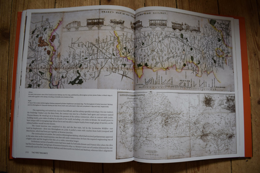
A summary chapter then follows on major lines such as the Grand Junction, London and Birmingham (both shown in the above image) and Great Western Railway (GWR) etc. featured under the heading 'Beginnings of a network'. I admit to needing to use a magnifying glass to see the details on most of the maps connected with the GWR which may disappoint fans of that railway.
The final chapter deals with railways outside Great Britain under the heading 'Transfer of technology'. This features several early railways firstly in the USA and then Continental Europe. From my point of view this is fine as the first American railroads were opened in the 1820s and 30s whereas European railways were mainly later.
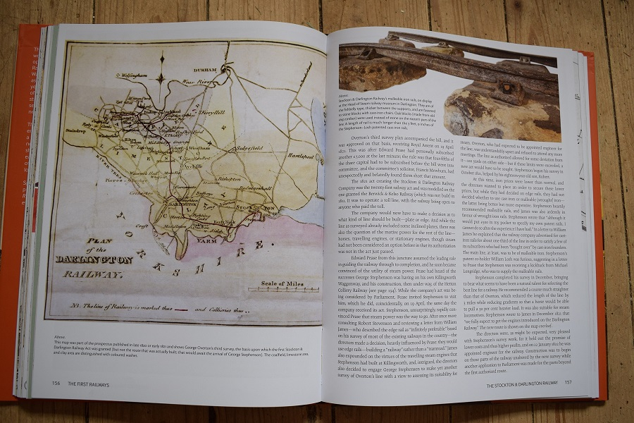
Looking in more detail at a couple of the chapters which describe the process of planning early railways may give a flavour of the book's contents. A long, 24 page, chapter on the Stockton and Darlington Railway includes survey maps from as far back as 1772 when the proposal was for a canal. Then we see the George Overton's first survey of 1818 for what was then called an "Intended Rail or Tram Road From the Collieries Near West Auckland by Darlington to Stockton".
Following Robert (Lighthouse) Stevenson's survey map of 1820 we see a reproduction of Overton's third survey, the second survey of 1819 not being reproduced. The author here recognises the problem of trying to get a long map onto the pages of a medium-sized book| â€The map is huge and consequently difficult to reproduce, being about 10 feet longâ€. Nevertheless, there it is, taking up over half the space on pages 154 and 155 but the text really is too small to read and two detailed enlargements of the Stockton and West Auckland areas are also given on these pages.
Under the chapter heading 'The first modern railway' we get a very detailed and comprehensive history of the projection of the Liverpool and Manchester Railway. The author again makes full use of his skills as a layout designer to display a large array of reproductions of the original survey maps mostly over two pages with smaller enlarged sections of maps to show detail related to the text.
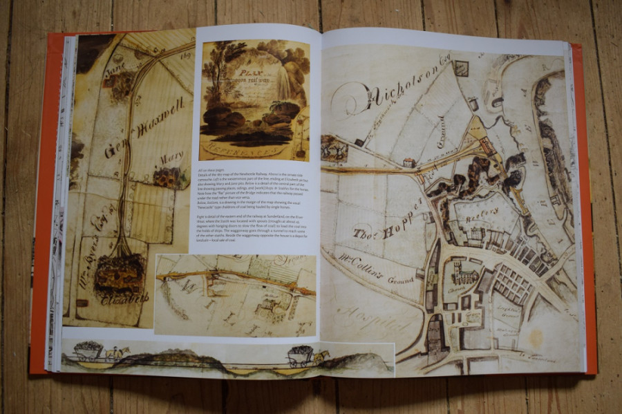
My favourite map is the 1817 hand drawn/painted map of the Newbottle Waggon railway. Again it is a long map at seven feet and is compiled from several photographs. This time it is only shown as a narrow strip at the bottom of a page with very little detail discernible to the naked eye. However various enlarged sections are also shown on several different pages (see image below). These reveal a detailed and annotated depiction of the railway including line gradients next to the track, the positions of sidings (passing loops), a steam-horse house which the author states could be the earliest representation of an engine shed. Another major reason for liking this map is that it was drawn at a transition period when iron rails were taking their modern form and steam locomotives were just starting to be introduced but horse haulage evidently remained important as there are stables shown on the map.
Two aspects I found disappointing were, firstly, the lack of references to the Bibliography which would allow the reader to find the source of quotations etc. and secondly, as in too many railway histories, there is barely a word about the first non-human type of motive power, the humble horse. Our equine helpers are, however, at least represented in many of the illustrations: in photographs and maps as well as in paintings and drawings.
One theme that interests me and runs through many of the railway maps is the inclusion of geological information. This is very clear from the multiple usage of an 1830 map by J. Walker showing not only railways but also 'various Mineral Productions throughout Great Britain' in others words, in a very basic way, showing the type of bedrock to be found there. So, for example, there would be names such as coal, ironstone and limestone to be seen across different areas. The map accompanying the Prospectus for the Stockton and Darlington Railway in 1820 has coloured areas representing coalfield (grey), limestone (yellow) and clay (brown) (see image below). I also noticed a couple of other maps which also include geological information: one from 1820 'Plan of the Line of the Central Junction Rail-way' depicts not only 'Railways executed, railways surveyed and planned, railways recognised' but also 'Mineral Districts' with various rock types given. Finally there is a map labelled '1867 survey' on page 65 which, in addition to railways and the Carmarthenshire Tram Road has, some very specific lines which look to me very much like coal seam outcrops, faultlines and dip arrows. In other words this looks to be a geological map of the South Wales coalfield. As an engineering geologist by training and experience I see that a very close connection exists between the beginnings of applied geology and the development of railways in a kind of symbiotic way which could be explained well in such maps but that needs to be developed in another publication.
At first sight it might seem strange that a Canadian author should have written this book which deals mainly with railways in Britain. Derek has written and designed many other thematic atlases primarily about railways in North America. It seems to me that as an outsider he is well placed to produced a work without preconceptions or prejudices (perhaps excepting the idea that a standard gauge existed from 1825!). In addition to that he has the ability to go to town in providing the needed visual backup for the text. For once I was reading a book that was written by somebody who not only had done his research but done it so thoroughly that almost nothing was left out and better still he could show me what he meant with highly relevant illustrations.
I personally feel it was a misjudgement to have produced the book in this format; many of the maps are simply crying out to be displayed adequately and some are really not easily visible even under magnifying lenses.
In summary this book is so stuffed full of information both in the text and in the illustrations that it should become a major work of reference for those who have want to learn about the beginnings of the railway.